

Semper Victor, this is all really impressive and useful stuff. Can you recommend me some of the written sources you're drawing from? I'm working on a little project of my own and these kinds of materials would be really helpful to me.
The Rise of the Sasanians
- Thread starter Semper Victor
- Start date
-
We have updated our Community Code of Conduct. Please read through the new rules for the forum that are an integral part of Paradox Interactive’s User Agreement.
You are using an out of date browser. It may not display this or other websites correctly.
You should upgrade or use an alternative browser.
You should upgrade or use an alternative browser.
Threadmarks
View all 68 threadmarks
Reader mode
Reader mode
Recent threadmarks
22. THE AFTERMATH OF EDESSA. ŠĀBUHR I’S SECOND ONSLAUGHT AGAINST THE ROMAN EAST. 20.3. ŠĀBUHR I’S SECOND CAMPAIGN. THE BATTLE OF BARBALISSOS. 20.4. ŠĀBUHR I’S SECOND CAMPAIGN. THE RAVAGING OF SYRIA AND THE FIRST CAPTURE OF ANTIOCH. 21.1. VALERIAN´S REIGN. THE PROMISING BEGINNINGS. 21.2. ŠĀBUHR I’S RETREAT. 24.6 THE REORGANIZATION OF THE ROMAN DEFENSES IN THE EAST BY DIOCLETIAN. 24.7 THE REIGN OF NARSĒ AND THE ROAD TO WAR. 24.8 THE WAR BETWEEN NARSĒ AND DIOCLETIAN AND THE FIRST PEACE TREATY OF NISIBIS.
0. Sources
Semper Victor, this is all really impressive and useful stuff. Can you recommend me some of the written sources you're drawing from? I'm working on a little project of my own and these kinds of materials would be really helpful to me.
Sure. First, I’ll recommend some books and later some articles. All of them by modern authors, although at the end I’ll add a short list of works by ancient authors (although bear in mind that I can’t read Latin, Greek or Persian, so I’m always relying on English translations.)
BOOKS:
- Leviathan vs. Behemoth: the Roman-Parthian wars 66 BC - 217 AD, by Cam Rea.
- The Parthian and early Sasanian empires: adaptation and expansion, a collection of scholarly essays edited by Vesta Sarkosh Curtis, Touraj Daryaee, Michael Alram and Elizabeth Pendleton.
- The Age of Parthians (part of the Idea of Iran series), a collection of scholarly essays edited by Vesta Sarkosh Curtis and Sarah Stewart.
- The Sasanian Era (part of the Idea of Iran series), a collection of scholarly essays edited by Vesta Sarkosh Curtis and Sarah Stewart.
- L’esercito romano tardoantico: persistenze e cesure dai Severi a Teodosio I, doctoral thesis by Marco Rocco.
- The Spirit of Zoroastrianism, by Prods Oktor Skjaervo.
- Rome and Persia in Late Antiquity: Neighbors and Rivals, by Beate Dignas and Engelbert Winter.
- Between Rome and Persia: The Middle Euphrates, Mesopotamia and Palmyra under Roman control, by Peter M. Edwell
- Legions in Crisis: Transformation of the Roman Soldier, 192-284, by Paul Elliott.
- The Roman Empire at Bay, 180-394, by David S. Potter.
- The Severans: The Changed Roman Empire, by Michael Grant.
- Emperor Alexander Severus: Rome’s Age of Insurrection, AD 222-235, by John S. McHugh.
- Maximinus Thrax: From Common Soldier to Emperor of Rome, by Paul N. Pearson.
- Imperial Triumph: The Roman World from Hadrian to Constantine, by Michael S. Kulikowski.
- The Fate of Rome, by Kyle Harper.
- L’armée romaine dans la tourmente: une nouvelle approche de la crise du III siècle, by Yann Le Bohec.
- The army of Severus Alexander, AD 222-235, doctoral thesis by Bernard Michael O’Hanlon.
- Caracalla: A Military Biography, by Ilkka Syvanne (to be used with caution).
- The Imperial Roman Army, by Yann Le Bohec.
- Histoire des guerres romaines, by Yann Le Bohec.
- Rome, the Greek World and the East, by Fergus Millar, Guy McLean Rogers and Hannah S.Cotton.
- Sasanian Society: I.Warriors II.Scribes III.Dehqans, by Ahmad Tafazzoli.
- Arsacids and Sasanians: Political Ideology in Post-Hellenistic and Late antique Persia, by M.Rahim Shayegan.
- Sasanian Persia: Portrait of a Late Antique Empire, by Touraj Daryaee.
- The Roman Eastern Frontier and the Persian Wars, AD 226-363, a collection of texts from ancient sources compiled and edited by Michael H.Dodgeon and Samuel N.C.Lieu.
- Ancient Persia, by Josef Wiesehöfer.
- ReOrienting the Sasanians, by Khodadad Rezakhani.
- Sasanian Persia: Between Rome and the Steppes of Eurasia, a collection of scholarly essays edited by Eberhard W. Sauer.
- Historia de las legiones romanas (2 vol.), by Julio Rodríguez González.
- A Political History of Parthia, by Neilson C.Debevoise.
- The Sistani Cycle of Epics and Iran's National History: on the Margins of Historiography, by Saghi Gazerani.
- History of the Goths, by Herwig Wolfram.
- Rome’s Gothic Wars, by Michael S. Kulikowski.
- L'imperatore prigioniero. Valeriano, la Persia e la disfatta di Edessa, by Omar Coloru. Editori Laterza, 2013.
- Die Zeit der Soldatenkaiser: Krise und Transformation des Römischen Reiches im 3. Jahrhundert n. Chr. (235-284), edited by Klaus-Peter Johne with participation by Udo Hartmann and Thomas Gerhardt. Akademie Verlag, 2009.
PAPERS:
- Manpower sources and army organisation in the Arsakid empire, by Marek Jan Olbrycht, published in Ancient Society no. 46 (2016).
- Parthian Cataphract vs. the Roman Army 53 BC-AD 224 , by Ilkka Syvanne, published in Historia I Swiat no.6 (2017).
- Ardaxšir and the Sasanians’ Rise to Power, by Touraj Daryaee, published in Anabasis: Studia Classica et Orientalia no.1 (2010).
- The Parthian nobility: its social position and political activity, by Edward Dabrowa, published in Parthica, no.15 (2014).
- Military and Society in Sasanian Iran, by Scott McDonough.
- Ethnic and Territorial Boundaries in Late Antique and early Medieval Persia, by Touraj Daryaee.
- C. Furius Sabinius Aquila Timesitheus, by Tommaso Gnoli (Università di Bologna).
- The Reign of the Emperor Philip the Arabian, by Lukas de Blois (Free University, Amsterdam).
- On the Chronology of the Gothic Invasions under Philippus and Decius (AD 248-251) by Dilyana Boteva, published in Archaeologia Bulgarica V (2001).
- "Scythica Vindobonensia” by Dexippus(?): New Fragments on Decius’ Gothic Wars, by Gunther MArtin and Jana Grusková, published in Greek, Roman, and Byzantine Studies 54 (2014).
- The Battle of Abritus, the Imperial Treasury and Aurei in Barbaricum, by Alexander Bursche, published in The Numismatic Chronicle 173 of the Royal Numismatic Society, London 2013.
- The Battle at Abritus in AD 251: Written Sources, Archaeological and Numismatic Data, by Galena Radoslavova, Georgi Dzanev and Nikolay Nikolov; published in Archaeologia Bulgarica XV, 3 (2011).
- A propos de la politique extérieure de Trébonien Galle, by Michel Christol; published in Revue numismatique, 6e série - Tome 22, année 1980.
- Apamée (1986): nouvelles donées sur l’armée romaine d’Orient et les raids sassanides du milieu du IIIe siècle; by Jean-Charles Balty, in Comptes rendus de l’Académie des Inscriptions et Belles-Lettres, 131e année.
ANCIENT SOURCES:
- Roman History, by Cassius Dio. It has arrived incomplete to our times, with whole books lacking and through the epitome written by the Byzantine monk John Xiphilinos. Still, it’s the essential source for the period 180-235 CE.
- History of the Empire from the Death of Marcus, by Herodian, in 8 books. Covers the period 180-238 CE.
- Parallel Lives, by Plutarch.
- Geographica, by Strabo.
- Antiquities of the Jews, by Flavius Josephus.
- Philippic History and Origins of the Entire World and All of its Lands, by Justin. He was an epitomizer of Pompeius Trogus’ massive Philippic Histories, originally written under August.
- Natural History, by Pliny the Elder.
- Historia Augusta, by an anonymous author/s known collectively as Scriptores Historiae Augustae (SHA). A very problematic source.
- Res Gestae, by Ammianus Marcellinus.
- De Caesaribus, by Sextus Aurelius Victor.
- Breviarium historiae Romanae, by Flavius Eutropius.
- Breviarium rerum gestarum populi Romani, by Festus.
- Epitome de Caesaribus (anonymous).
- New History, by Zosimus.
- De origine actibusque Getarum (Getica), by Jordanes.
- Extract of Chronography, by George Syncellus.
- Extracts of History, by John Zonaras.
- Shahnameh (the “Book of Kings”), the great epic poem of Persian literature, by Abdolqasem Ferdowsi.
- Tarikh-e Sistan (History of Sistan, in Persian), by an anonymous author.
- History of the Prophets and Kings, written in Arabic by the Persian scholar Muḥammad ibn Jarīr al-Ṭabarī. It was later translated into Persian by Bal’ami, who added many new details missing in Tabari’s original work.
- Meadows of Gold and Mines of Gems, written in Arabic by Ali al-Mas’udi.
- History of Armenia, by Moses of Chorene (in Armenian).
- History of Saint Gregory and the Conversion of Armenia, by Agathangelos (in Armenian).
Last edited:
5.4. THE ARSACID MILITARY. STRATEGIC COMPARATIVE WITH ROME.
5.4. THE ARSACID MILITARY. STRATEGIC COMPARATIVE WITH ROME.
At its peak, the Roman empire had a population between 50 and 75 million people, and fielded a well trained professional army which increased in numbers steadily from Augustus’ reign onwards. Apart from available manpower and trained soldiers, Rome also had at its disposal fiscal and economic resources much higher than those available to the Arsacid kings.
According to Yann Le Bohec and Adrian Goldsworthy, the total numbers of the Roman army (including the forces stationed in Rome itself) grew steadily in numbers from Augustus’ death to the age of the Severans:

Map showing the full deployment of all Roman legions in 125 CE (under Hadrian).
Considering the burden that the maintenance of a permanent army imposed on pre-industrial societies, it’s clear that this increase reflected a growing concern towards the eastern Roman border.
The Arsacid empire, with its much smaller human, economic and human resources, was able to compete with Rome (punching well above its weight class) because in the Iranian plateau it had a huge reserve of mobilizable experienced fighters which were not on the king’s payroll. Compared to Roman society, the society of the Iranian plateau was hyper militarized. Coupled with geography, this was the reason that turned the Iranian-based empires of the Arsacids and Sasanians into such dangerous enemies for the Romans.
But this key strength was also the Arsacids’ main weakness. Usually, a hyper militarized society is also a highly volatile and unstable one, and ancient Iran was no exception to the rule. The warrior clans that ruled the Iranian plateau behaved according to an ethos that judged that only war, hunting and drinking were suitable pastimes for them; coupled with the agnatic hereditary system, the result was a very unruly society. While the Arsacid empire was expanding in the III, II and early I centuries BCE, there were no troubles because the grandees and the Arsacid kings were united in the pursue of expansion, which meant more riches and lands to everybody. But when expansion stopped around the same time that the Arsacids first clashed with Rome, this warlike energy was turned inwards and led to continuous civil wars from Ūrūd II’s reign until the fall of the House of Aršak.
By comparison, in this same period of time the Roman empire enjoyed a golden age of (relative) political stability (especially under the Antonines) and great demographic and economic growth. This blatant difference between the internal situation in both empires incited Roman aggression, and in the II century CE led to three great scale Roman invasions that ended all of them in the capture and looting of the Arsacid main capital at Ctesiphon.
The “feudalizing” organization of Arsacid armies also imposed quite sharp restrictions on what the Arsacid kings could achieve with them.
First of all, as the Arsacid king would be waging war not with “his” own army, but with the armies of the great clans, he needed to convince them that it would be worth it. With hindsight, it’s clear that if they supported the Arsacids and Sasanians for so long, they had an interest in preserving the statu quo (with tradition and custom also playing a part in it), but Classical authors were very aware of this key weakness of the “Parthians”. The Iranian clans showed themselves usually keen to defend their homeland (although probably what they considered as “homeland” stopped at the Zagros), but they disliked long campaigns far from their lands, especially if they involved lots of sieges, hard fighting and little loot. It’s unclear if there were “feudal obligations” like in the European Middle Age, but ancient accounts seem to suggest that the nobility did not feel itself compelled to stay in the field supporting their king for long periods of time. Also, there were no centralized logistics: every clan’s army brought its own supplies, and when they were finished (or they thought their duty was done, whatever happened first) they just quit and went home. A part of those armies would also be formed by herders, peasants and other workers who could not afford to stay away from their livelihoods for extended periods of time.
This meant that, if pressed hardly by the Arsacid army and wanting to avoid a field battle, it was a sure bet for the Romans to just fortify themselves (in a field encampment or in a walled city) and wait the “Parthians” out. After his near defeat at Nisibis in 217 CE, emperor Macrianus just opened peace talks with Ardawān V and kept stretching them until Ardawān’s army melted away as time went by.
The nature of Iranian society meant that, if we count the years between the battles of Carrhae (54 BCE) and Nisibis (217 CE), which were the first and last battles between both powers, the Arsacids actually spent many more years fighting among themselves or quelling nobiliary uprisings than fighting the Romans or any other foreign enemy (even if we add all of them together). And in the case of civil wars, neither members of the House of Aršak nor members of the nobility showed any kind or reluctance in calling for Roman help.
Rome could support a war for a long time, provided it happened in only a single theater (the great weakness of the Roman military was its incapability of waging war at the same time in two or more fronts). But the Arsacids, due to all the handicaps already mentioned, could only handle short wars.
Arsacid cavalry armies could be used both in defensive or offensive roles, and could also be employed to fight conventional, pitched battles, or to wage “guerrilla” campaigns to wear the enemy down. Their great weakness was their uselessness against fortifications (which is quite puzzling, because during their expansion the Arsacids had to take many walled cities, some of them truly formidable ones).
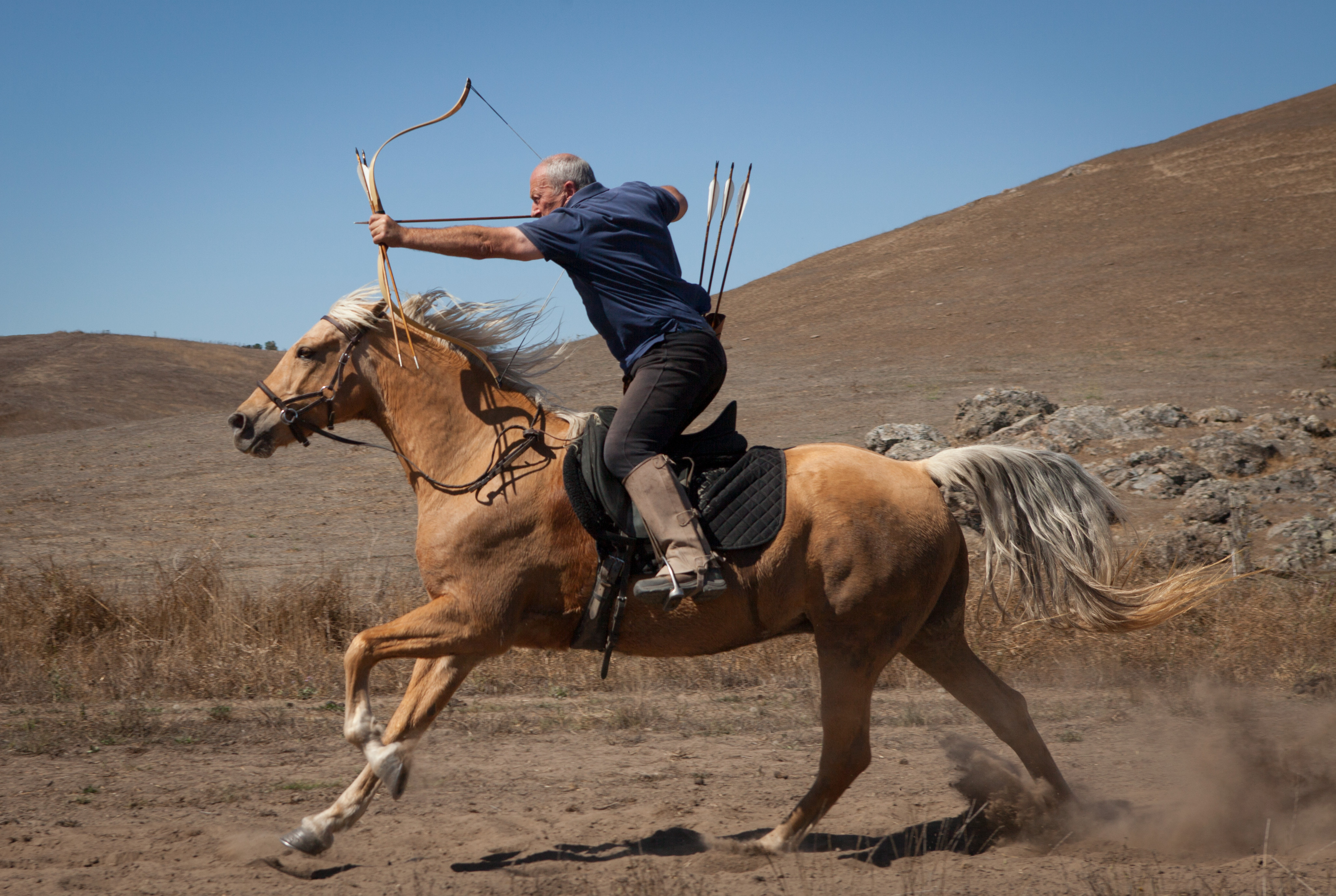
Californian archer Mike Loades performing one of the shot modalities practised by ancient Iranians; as seen in some ancient reliefs, he holds two more arrows with the hand that holds the bow for rapid fire. This technique allowed for rapid "shower fire" at the cost of lower accuracy.
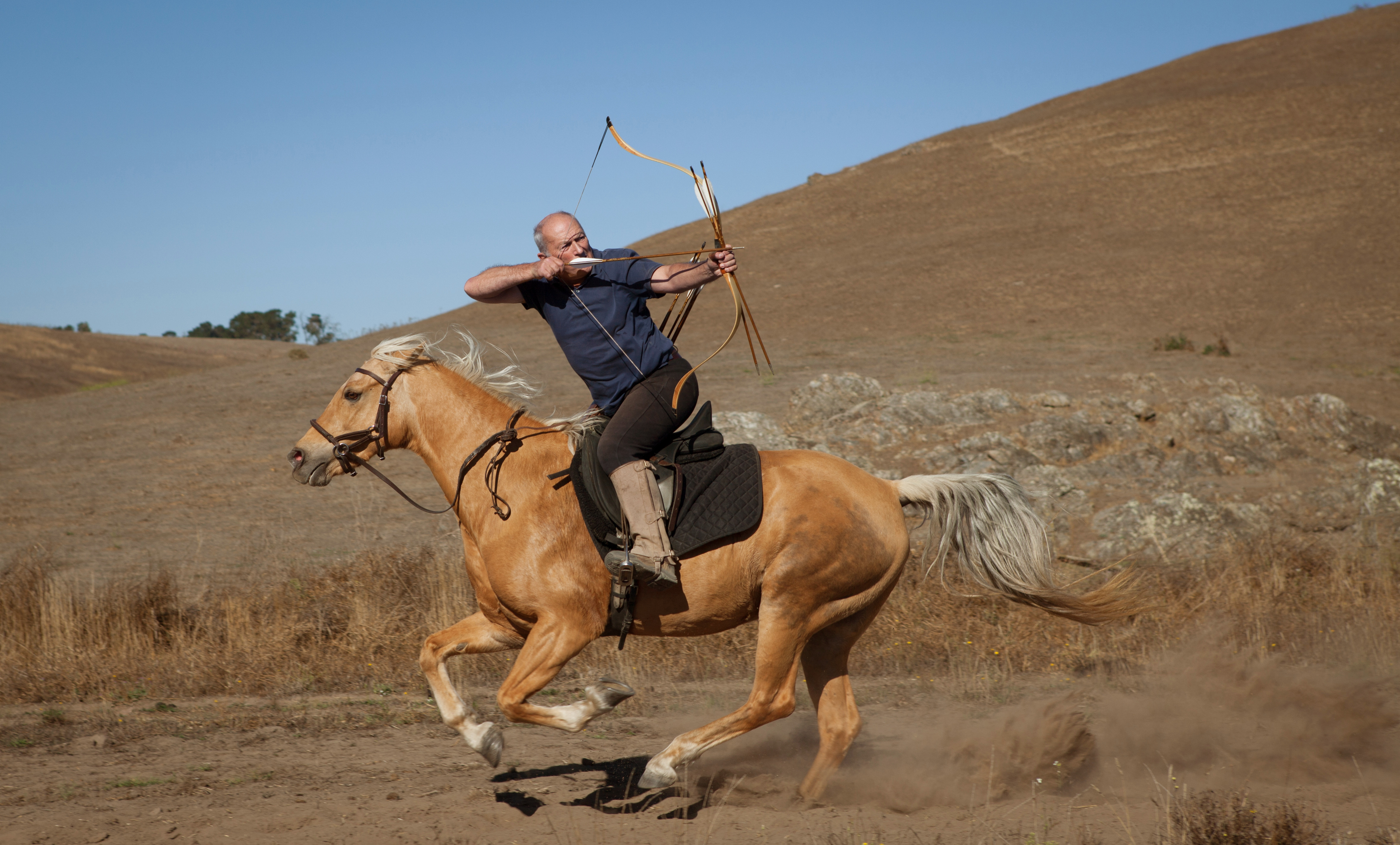
And again Mike Loades performing the same shot backwards; this is the famous "Parthian shot".
The situation was exactly the opposite for the Romans. Thanks to its large professional army, Rome could sustain long wars with plenty of losses, sieges, and lack of opportunities for looting. But these armies were mainly infantry armies, very cumbersome when compared with the Arsacid cavalry ones. They were useless in indirect, “guerrilla warfare” and to win campaigns, they needed “hard” objectives to hit: either enemy cities or fortresses, or to fight pitched battles against the enemy main army. As the Arsacid armies could (and would) always elude the Roman infantry armies if they wanted to, the Romans never managed to really inflict a crushing defeat against the Arsacids. The only targets they could hit without them running away were the great Mesopotamian cities, which they took several times without managing to bring down the Arsacid empire down.
But these attacks took their own toll. First, the annexation of northern Mesopotamia (Osrhoene and western Adiabene) temporarily under Lucius Verus and for good under Septimius Severus was a hard blow against the prestige of the dynasty, as it brought the Roman border dangerously close to Media, inserted a strategic wedge between Armenia (ruled by an Arsacid) and Mesopotamia and allowed the Romans to reach Ctesiphon in a much quicker and easier way. Also Mesopotamia, which became the main marching field for Rome’s legions, was the main power base of the House of Aršak itself (together possibly with royal estates in Parthia proper), and so, if Roman attacks did not bring the Iranian empire down, they did weaken the position of the Arsacid royal house in front of its dangerous nobility, both by sapping directly the fiscal and human resources available to them, and most seriously of all, by damaging the prestige of the dynasty.
Despite all the deep differences between Roman and Iranian societies, both the Roman emperor and the Iranian šahanšah (Arsacid or Sasanian) had something in common: they were war leaders first and foremost, and their fundamental role was to lead their armies to victory. If they failed in their main raison d’être, both could and would be replaced; the only difference was that as in Iran the dynastic principle was sacred, his successor would be chosen amongst his surviving relatives. The most extreme, almost comical, case is that of the Sasanian šahanšah Šabuhr II, who was said to have been crowned while still inside his mother’s womb.
Both cultures expressed this reality through elusive abstract concepts: Romans would talk about the fortuna, genius, felicitas or virtus of their emperor, while Iranians expressed it most succinctly through a concept rooted in Zoroastrian tradition, that of fārr, which translates as “kingly glory”. Fārr was an intangible quality with which Ohrmazd himself invested the king. In Iranian art, especially in Sasanian rock reliefs (although it has precedents in Arsacid times) this was expressed in a scene in which Ohrmazd or one of the yazdān (usually Mihr or Anahid) handed over a “ring of power” to the šahanšah.
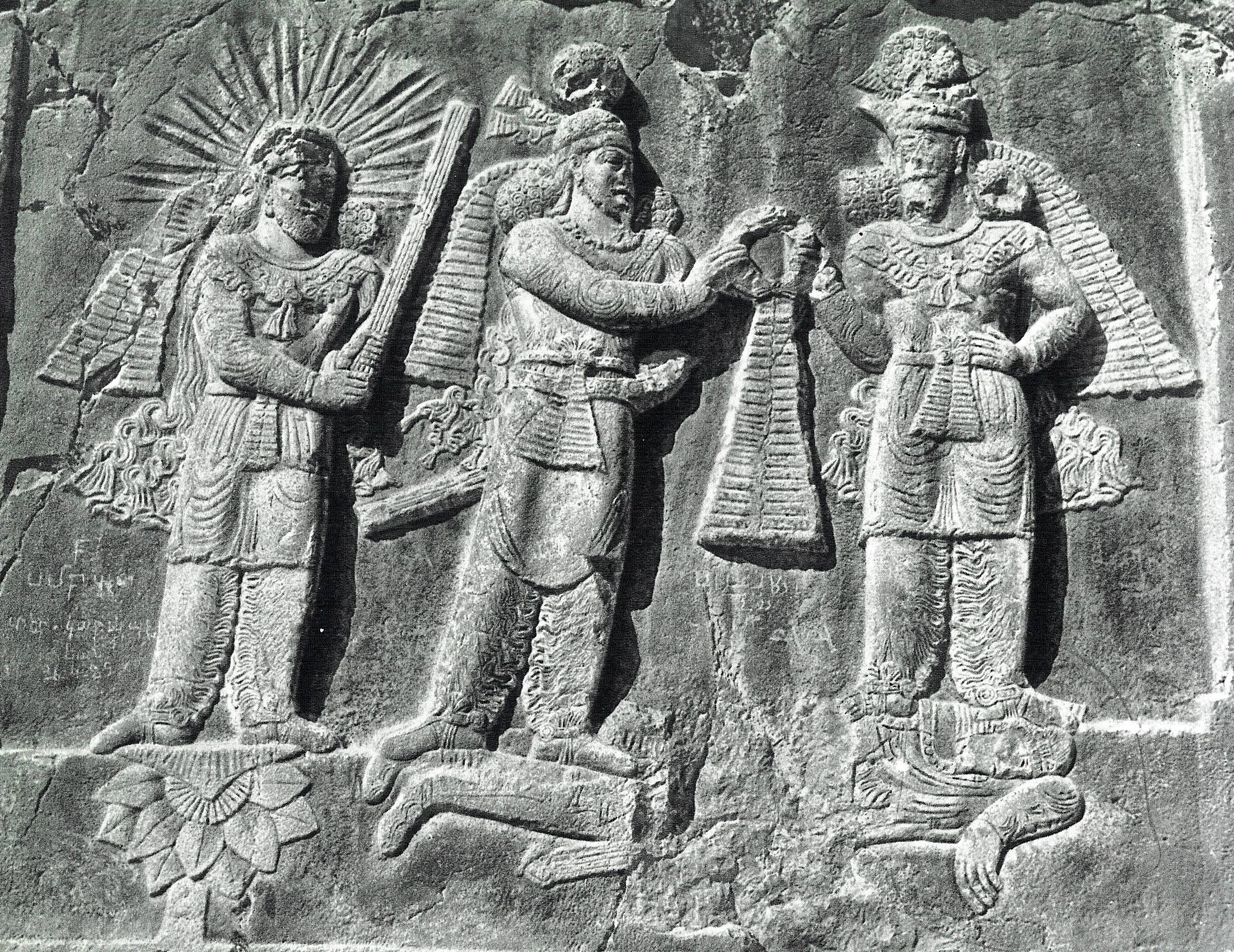
Investiture relief of the Sasanian šahanšah Ardaxšir II. The king stands in the center, and is receiving the ring of power from the supreme god Ohrmazd (on the right), while the god Mihr (known to the Romans as Mithra) stands to the left.
At its peak, the Roman empire had a population between 50 and 75 million people, and fielded a well trained professional army which increased in numbers steadily from Augustus’ reign onwards. Apart from available manpower and trained soldiers, Rome also had at its disposal fiscal and economic resources much higher than those available to the Arsacid kings.
According to Yann Le Bohec and Adrian Goldsworthy, the total numbers of the Roman army (including the forces stationed in Rome itself) grew steadily in numbers from Augustus’ death to the age of the Severans:
- Under Tiberius: 300,000 men.
- Under Trajan: 360,000 to 380,000 men.
- Under Septimius Severus: more than 500,000 men.
- Legio VI Ferrata, based at Ancyra (Cappadocia).
- Legio IV Scythica, based at Cyrrhus (Syria).
- Legio III Gallica, based at Antiochia (Syria).
- Legio XII Fulminata, based at Raphanaea (Syria).
- Legio XXII Deiotariana, based at Nicopolis (Egypt).
- Legio III Cyrenaica, based at Coptos (Egypt).
- Legio XVI Flavia Firma, based at Satala (Cappadocia).
- Legio XII Fulminata, based at Melitene (Cappadocia).
- Legio VI Ferrata, based at Samosata (Syria).
- Legio IV Scythica, based at Zeugma (Syria).
- Legio III Gallica, based at Raphanaea (Syria).
- Legio X Fretensis, based at Hyerosolima (Iudaea)
- Legio XXII Deiotariana, based at Nicopolis (Egypt).
- Legio III Cyrenaica, based at Coptos (Egypt).
- Legio XV Apollinaris, based at Satala (Cappadocia).
- Legio XII Fulminata, based at Melitene (Cappadocia).
- Legio IV Scythica, based at Zeugma (Syria).
- Legio XVI Flavia Firma, based at Samosata (Syria).
- Legio III Gallica, based at Raphanaea (Syria).
- Legio X Fretensis, based at Aelia Capitolina (Syria Palaestina).
- Legio VI Ferrata, based at Caparcotna (Syria Palaestina).
- Legio III Cyrenaica, based at Bostra (Arabia Petrea).
- Legio II Traiana Fortis, based at Nicopolis (Egypt).
- Legio XV Apollinaris, based at Satala (Cappadocia).
- Legio XII Fulminata, based at Melitene (Cappadocia).
- Legio III Parthica, based at Nisibis (Mesopotamia).
- Legio I Parthica, based at Singara (Mesopotamia).
- Legio IV Scythica, based at Zeugma (Syria Coele).
- Legio XVI Flavia Firma, based at Sura (Syria Coele).
- Legio III Gallica, based at Darsaba (Syria Phoenicia).
- Legio X Fretensis, based at Aelia Capitolina (Syria Palaestina).
- Legio VI Ferrata, based at Caparcotna (Syria Palaestina).
- Legio III Cyrenaica, based at Bostra (Arabia Petrea).
- Legio II Traiana Fortis, based at Nicopolis (Egypt).
Map showing the full deployment of all Roman legions in 125 CE (under Hadrian).
Considering the burden that the maintenance of a permanent army imposed on pre-industrial societies, it’s clear that this increase reflected a growing concern towards the eastern Roman border.
The Arsacid empire, with its much smaller human, economic and human resources, was able to compete with Rome (punching well above its weight class) because in the Iranian plateau it had a huge reserve of mobilizable experienced fighters which were not on the king’s payroll. Compared to Roman society, the society of the Iranian plateau was hyper militarized. Coupled with geography, this was the reason that turned the Iranian-based empires of the Arsacids and Sasanians into such dangerous enemies for the Romans.
But this key strength was also the Arsacids’ main weakness. Usually, a hyper militarized society is also a highly volatile and unstable one, and ancient Iran was no exception to the rule. The warrior clans that ruled the Iranian plateau behaved according to an ethos that judged that only war, hunting and drinking were suitable pastimes for them; coupled with the agnatic hereditary system, the result was a very unruly society. While the Arsacid empire was expanding in the III, II and early I centuries BCE, there were no troubles because the grandees and the Arsacid kings were united in the pursue of expansion, which meant more riches and lands to everybody. But when expansion stopped around the same time that the Arsacids first clashed with Rome, this warlike energy was turned inwards and led to continuous civil wars from Ūrūd II’s reign until the fall of the House of Aršak.
By comparison, in this same period of time the Roman empire enjoyed a golden age of (relative) political stability (especially under the Antonines) and great demographic and economic growth. This blatant difference between the internal situation in both empires incited Roman aggression, and in the II century CE led to three great scale Roman invasions that ended all of them in the capture and looting of the Arsacid main capital at Ctesiphon.
The “feudalizing” organization of Arsacid armies also imposed quite sharp restrictions on what the Arsacid kings could achieve with them.
First of all, as the Arsacid king would be waging war not with “his” own army, but with the armies of the great clans, he needed to convince them that it would be worth it. With hindsight, it’s clear that if they supported the Arsacids and Sasanians for so long, they had an interest in preserving the statu quo (with tradition and custom also playing a part in it), but Classical authors were very aware of this key weakness of the “Parthians”. The Iranian clans showed themselves usually keen to defend their homeland (although probably what they considered as “homeland” stopped at the Zagros), but they disliked long campaigns far from their lands, especially if they involved lots of sieges, hard fighting and little loot. It’s unclear if there were “feudal obligations” like in the European Middle Age, but ancient accounts seem to suggest that the nobility did not feel itself compelled to stay in the field supporting their king for long periods of time. Also, there were no centralized logistics: every clan’s army brought its own supplies, and when they were finished (or they thought their duty was done, whatever happened first) they just quit and went home. A part of those armies would also be formed by herders, peasants and other workers who could not afford to stay away from their livelihoods for extended periods of time.
This meant that, if pressed hardly by the Arsacid army and wanting to avoid a field battle, it was a sure bet for the Romans to just fortify themselves (in a field encampment or in a walled city) and wait the “Parthians” out. After his near defeat at Nisibis in 217 CE, emperor Macrianus just opened peace talks with Ardawān V and kept stretching them until Ardawān’s army melted away as time went by.
The nature of Iranian society meant that, if we count the years between the battles of Carrhae (54 BCE) and Nisibis (217 CE), which were the first and last battles between both powers, the Arsacids actually spent many more years fighting among themselves or quelling nobiliary uprisings than fighting the Romans or any other foreign enemy (even if we add all of them together). And in the case of civil wars, neither members of the House of Aršak nor members of the nobility showed any kind or reluctance in calling for Roman help.
Rome could support a war for a long time, provided it happened in only a single theater (the great weakness of the Roman military was its incapability of waging war at the same time in two or more fronts). But the Arsacids, due to all the handicaps already mentioned, could only handle short wars.
Arsacid cavalry armies could be used both in defensive or offensive roles, and could also be employed to fight conventional, pitched battles, or to wage “guerrilla” campaigns to wear the enemy down. Their great weakness was their uselessness against fortifications (which is quite puzzling, because during their expansion the Arsacids had to take many walled cities, some of them truly formidable ones).
Californian archer Mike Loades performing one of the shot modalities practised by ancient Iranians; as seen in some ancient reliefs, he holds two more arrows with the hand that holds the bow for rapid fire. This technique allowed for rapid "shower fire" at the cost of lower accuracy.
And again Mike Loades performing the same shot backwards; this is the famous "Parthian shot".
The situation was exactly the opposite for the Romans. Thanks to its large professional army, Rome could sustain long wars with plenty of losses, sieges, and lack of opportunities for looting. But these armies were mainly infantry armies, very cumbersome when compared with the Arsacid cavalry ones. They were useless in indirect, “guerrilla warfare” and to win campaigns, they needed “hard” objectives to hit: either enemy cities or fortresses, or to fight pitched battles against the enemy main army. As the Arsacid armies could (and would) always elude the Roman infantry armies if they wanted to, the Romans never managed to really inflict a crushing defeat against the Arsacids. The only targets they could hit without them running away were the great Mesopotamian cities, which they took several times without managing to bring down the Arsacid empire down.
But these attacks took their own toll. First, the annexation of northern Mesopotamia (Osrhoene and western Adiabene) temporarily under Lucius Verus and for good under Septimius Severus was a hard blow against the prestige of the dynasty, as it brought the Roman border dangerously close to Media, inserted a strategic wedge between Armenia (ruled by an Arsacid) and Mesopotamia and allowed the Romans to reach Ctesiphon in a much quicker and easier way. Also Mesopotamia, which became the main marching field for Rome’s legions, was the main power base of the House of Aršak itself (together possibly with royal estates in Parthia proper), and so, if Roman attacks did not bring the Iranian empire down, they did weaken the position of the Arsacid royal house in front of its dangerous nobility, both by sapping directly the fiscal and human resources available to them, and most seriously of all, by damaging the prestige of the dynasty.
Despite all the deep differences between Roman and Iranian societies, both the Roman emperor and the Iranian šahanšah (Arsacid or Sasanian) had something in common: they were war leaders first and foremost, and their fundamental role was to lead their armies to victory. If they failed in their main raison d’être, both could and would be replaced; the only difference was that as in Iran the dynastic principle was sacred, his successor would be chosen amongst his surviving relatives. The most extreme, almost comical, case is that of the Sasanian šahanšah Šabuhr II, who was said to have been crowned while still inside his mother’s womb.
Both cultures expressed this reality through elusive abstract concepts: Romans would talk about the fortuna, genius, felicitas or virtus of their emperor, while Iranians expressed it most succinctly through a concept rooted in Zoroastrian tradition, that of fārr, which translates as “kingly glory”. Fārr was an intangible quality with which Ohrmazd himself invested the king. In Iranian art, especially in Sasanian rock reliefs (although it has precedents in Arsacid times) this was expressed in a scene in which Ohrmazd or one of the yazdān (usually Mihr or Anahid) handed over a “ring of power” to the šahanšah.
Investiture relief of the Sasanian šahanšah Ardaxšir II. The king stands in the center, and is receiving the ring of power from the supreme god Ohrmazd (on the right), while the god Mihr (known to the Romans as Mithra) stands to the left.
Last edited:
I just realised that I know absolutely nothing about the inner politics of either the Parthian or Sasanian Empire.
Well, now you do, don't youI just realised that I know absolutely nothing about the inner politics of either the Parthian or Sasanian Empire.
")
Thanks for this yet again informative and well written chapter on the Parthians!
BTW is it just me or does Ohrmazd have the exact same dress and appearance as the king to which he is giving his ring?? How comes.
5.3. THE ARSACID MILITARY. STRATEGIC COMPARATIVE WITH ROME.
At its peak, the Roman empire had a population between 50 and 75 million people, and fielded a well trained professional army which increased in numbers steadily from Augustus’ reign onwards. Apart from available manpower and trained soldiers, Rome also had at its disposal fiscal and economic resources much higher than those available to the Arsacid kings.
According to Yann Le Bohec and Adrian Goldsworthy, the total numbers of the Roman army (including the forces stationed in Rome itself) grew steadily in numbers from Augustus’ death to the age of the Severans:
In parallel to this overall increase in armed strength, the Romans kept increasing the garrisoning forces of their eastern provinces during the Principate. Under Augustus, the eastern provinces were garrisoned by the following legions (6 in total), with their corresponding auxiliary units (that according to Tacitus amounted usually to the same numbers as those of the legionaries they accompanied):
- Under Tiberius: 300,000 men.
- Under Trajan: 360,000 to 380,000 men.
- Under Septimius Severus: more than 500,000 men.
In parallel to the increase in numbers, the tendency was to move the legions closer to the borders as time went by; under the Flavians they were definitively posted at or very near to the borders. Under Titus (79-80 CE), there were in the East 8 legions:
- Legio VI Ferrata, based at Ancyra (Cappadocia).
- Legio IV Scythica, based at Cyrrhus (Syria).
- Legio III Gallica, based at Antiochia (Syria).
- Legio XII Fulminata, based at Raphanaea (Syria).
- Legio XXII Deiotariana, based at Nicopolis (Egypt).
- Legio III Cyrenaica, based at Coptos (Egypt).
By the time of Marcus Aurelius’ death (180 CE), this number grew to 9 legions, and Egypt had lost one of its legions in benefit of the Levant:
- Legio XVI Flavia Firma, based at Satala (Cappadocia).
- Legio XII Fulminata, based at Melitene (Cappadocia).
- Legio VI Ferrata, based at Samosata (Syria).
- Legio IV Scythica, based at Zeugma (Syria).
- Legio III Gallica, based at Raphanaea (Syria).
- Legio X Fretensis, based at Hyerosolima (Iudaea)
- Legio XXII Deiotariana, based at Nicopolis (Egypt).
- Legio III Cyrenaica, based at Coptos (Egypt).
And by the time of the death of Severus Alexander (235 CE), the grand total had grown to 11 legions:
- Legio XV Apollinaris, based at Satala (Cappadocia).
- Legio XII Fulminata, based at Melitene (Cappadocia).
- Legio IV Scythica, based at Zeugma (Syria).
- Legio XVI Flavia Firma, based at Samosata (Syria).
- Legio III Gallica, based at Raphanaea (Syria).
- Legio X Fretensis, based at Aelia Capitolina (Syria Palaestina).
- Legio VI Ferrata, based at Caparcotna (Syria Palaestina).
- Legio III Cyrenaica, based at Bostra (Arabia Petrea).
- Legio II Traiana Fortis, based at Nicopolis (Egypt).
- Legio XV Apollinaris, based at Satala (Cappadocia).
- Legio XII Fulminata, based at Melitene (Cappadocia).
- Legio III Parthica, based at Nisibis (Mesopotamia).
- Legio I Parthica, based at Singara (Mesopotamia).
- Legio IV Scythica, based at Zeugma (Syria Coele).
- Legio XVI Flavia Firma, based at Sura (Syria Coele).
- Legio III Gallica, based at Darsaba (Syria Phoenicia).
- Legio X Fretensis, based at Aelia Capitolina (Syria Palaestina).
- Legio VI Ferrata, based at Caparcotna (Syria Palaestina).
- Legio III Cyrenaica, based at Bostra (Arabia Petrea).
- Legio II Traiana Fortis, based at Nicopolis (Egypt).
Map showing the full deployment of all Roman legions in 125 CE (under Hadrian).
Considering the burden that the maintenance of a permanent army imposed on pre-industrial societies, it’s clear that this increase reflected a growing concern towards the eastern Roman border.
The Arsacid empire, with its much smaller human, economic and human resources, was able to compete with Rome (punching well above its weight class) because in the Iranian plateau it had a huge reserve of mobilizable experienced fighters which were not on the king’s payroll. Compared to Roman society, the society of the Iranian plateau was hyper militarized. Coupled with geography, this was the reason that turned the Iranian-based empires of the Arsacids and Sasanians into such dangerous enemies for the Romans.
But this key strength was also the Arsacids’ main weakness. Usually, a hyper militarized society is also a highly volatile and unstable one, and ancient Iran was no exception to the rule. The warrior clans that ruled the Iranian plateau behaved according to an ethos that judged that only war, hunting and drinking were suitable pastimes for them; coupled with the agnatic hereditary system, the result was a very unruly society. While the Arsacid empire was expanding in the III, II and early I centuries BCE, there were no troubles because the grandees and the Arsacid kings were united in the pursue of expansion, which meant more riches and lands to everybody. But when expansion stopped around the same time that the Arsacids first clashed with Rome, this warlike energy was turned inwards and led to continuous civil wars from Ūrūd II’s reign until the fall of the House of Aršak.
By comparison, in this same period of time the Roman empire enjoyed a golden age of (relative) political stability (especially under the Antonines) and great demographic and economic growth. This blatant difference between the internal situation in both empires incited Roman aggression, and in the II century CE led to three great scale Roman invasions that ended all of them in the capture and looting of the Arsacid main capital at Ctesiphon.
The “feudalizing” organization of Arsacid armies also imposed quite sharp restrictions on what the Arsacid kings could achieve with them.
First of all, as the Arsacid king would be waging war not with “his” own army, but with the armies of the great clans, he needed to convince them that it would be worth it. With hindsight, it’s clear that if they supported the Arsacids and Sasanians for so long, they had an interest in preserving the statu quo (with tradition and custom also playing a part in it), but Classical authors were very aware of this key weakness of the “Parthians”. The Iranian clans showed themselves usually keen to defend their homeland (although probably what they considered as “homeland” stopped at the Zagros), but they disliked long campaigns far from their lands, especially if they involved lots of sieges, hard fighting and little loot. It’s unclear if there were “feudal obligations” like in the European Middle Age, but ancient accounts seem to suggest that the nobility did not feel itself compelled to stay in the field supporting their king for long periods of time. Also, there were no centralized logistics: every clan’s army brought its own supplies, and when they were finished (or they thought their duty was done, whatever happened first) they just quit and went home. A part of those armies would also be formed by herders, peasants and other workers who could not afford to stay away from their livelihoods for extended periods of time.
This meant that, if pressed hardly by the Arsacid army and wanting to avoid a field battle, it was a sure bet for the Romans to just fortify themselves (in a field encampment or in a walled city) and wait the “Parthians” out. After his near defeat at Nisibis in 217 CE, emperor Macrianus just opened peace talks with Ardawān V and kept stretching them until Ardawān’s army melted away as time went by.
The nature of Iranian society meant that, if we count the years between the battles of Carrhae (54 BCE) and Nisibis (217 CE), which were the first and last battles between both powers, the Arsacids actually spent many more years fighting among themselves or quelling nobiliary uprisings than fighting the Romans or any other foreign enemy (even if we add all of them together). And in the case of civil wars, neither members of the House of Aršak nor members of the nobility showed any kind or reluctance in calling for Roman help.
Rome could support a war for a long time, provided it happened in only a single theater (the great weakness of the Roman military was its incapability of waging war at the same time in two or more fronts). But the Arsacids, due to all the handicaps already mentioned, could only handle short wars.
Arsacid cavalry armies could be used both in defensive or offensive roles, and could also be employed to fight conventional, pitched battles, or to wage “guerrilla” campaigns to wear the enemy down. Their great weakness was their uselessness against fortifications (which is quite puzzling, because during their expansion the Arsacids had to take many walled cities, some of them truly formidable ones).
Californian archer Mike Loades performing one of the shot modalities practised by ancient Iranians; as seen in some ancient reliefs, he holds two more arrows with the hand that holds the bow for rapid fire. This technique allowed for rapid "shower fire" at the cost of lower accuracy.
And again Mike Loades performing the same shot backwards; this is the famous "Parthian shot".
The situation was exactly the opposite for the Romans. Thanks to its large professional army, Rome could sustain long wars with plenty of losses, sieges, and lack of opportunities for looting. But these armies were mainly infantry armies, very cumbersome when compared with the Arsacid cavalry ones. They were useless in indirect, “guerrilla warfare” and to win campaigns, they needed “hard” objectives to hit: either enemy cities or fortresses, or to fight pitched battles against the enemy main army. As the Arsacid armies could (and would) always elude the Roman infantry armies if they wanted to, the Romans never managed to really inflict a crushing defeat against the Arsacids. The only targets they could hit without them running away were the great Mesopotamian cities, which they took several times without managing to bring down the Arsacid empire down.
But these attacks took their own toll. First, the annexation of northern Mesopotamia (Osrhoene and western Adiabene) temporarily under Lucius Verus and for good under Septimius Severus was a hard blow against the prestige of the dynasty, as it brought the Roman border dangerously close to Media, inserted a strategic wedge between Armenia (ruled by an Arsacid) and Mesopotamia and allowed the Romans to reach Ctesiphon in a much quicker and easier way. Also Mesopotamia, which became the main marching field for Rome’s legions, was the main power base of the House of Aršak itself (together possibly with royal estates in Parthia proper), and so, if Roman attacks did not bring the Iranian empire down, they did weaken the position of the Arsacid royal house in front of its dangerous nobility, both by sapping directly the fiscal and human resources available to them, and most seriously of all, by damaging the prestige of the dynasty.
Despite all the deep differences between Roman and Iranian societies, both the Roman emperor and the Iranian šahanšah (Arsacid or Sasanian) had something in common: they were war leaders first and foremost, and their fundamental role was to lead their armies to victory. If they failed in their main raison d’être, both could and would be replaced; the only difference was that as in Iran the dynastic principle was sacred, his successor would be chosen amongst his surviving relatives. The most extreme, almost comical, case is that of the Sasanian šahanšah Šabuhr II, who was said to have been crowned while still inside his mother’s womb.
Both cultures expressed this reality through elusive abstract concepts: Romans would talk about the fortuna, genius, felicitas or virtus of their emperor, while Iranians expressed it most succinctly through a concept rooted in Zoroastrian tradition, that of fārr, which translates as “kingly glory”. Fārr was an intangible quality with which Ohrmazd himself invested the king. In Iranian art, especially in Sasanian rock reliefs (although it has precedents in Arsacid times) this was expressed in a scene in which Ohrmazd or one of the yazdān (usually Mihr or Anahid) handed over a “ring of power” to the šahanšah.
Investiture relief of the Sasanian šahanšah Ardaxšir II. The king stands in the center, and is receiving the ring of power from the supreme god Ohrmazd (on the right), while the god Mihr (known to the Romans as Mithra) stands to the left.
"One Ring to Rule Them All"? xD
Well, now you do, don't you
Thanks for this yet again informative and well written chapter on the Parthians!
BTW is it just me or does Ohrmazd have the exact same dress and appearance as the king to which he is giving his ring?? How comes.
That's a good question. I'll deal with this with more detail later, but the fact is that from the first to the last Sasanian king to be represented in such rock relieves in investiture scenes (already in the VII century CE), they're always represented at the same level and with the same stature of the gods.
In the case of the first kings (only during the III century CE, this custom stopped later, probably because of the opposition of the Zoroastrian clergy and their newly developed "orthodoxy"), they specifically referred to themselves and their ancestors literally as "(he) whose seed is from the gods", implicitly claiming divine status for themselves.
"One Ring to Rule Them All"? xD
Scholars call them so because nobody has the slightest idea of what they were called in reality, or what they were exactly. Actually, they could also be a torques, or a diadem.Diadem-with-scarf is how it looks to me
Overall, though, a very informative thread.
Don't you mean Ionic?How ironic.
@Semper Victor, excellent posts! Very interesting and informative.
I have a few questions and a few points to raise though.
Firstly about the division of Iranian society into settled and nomadic populations. Where there long-standing ethnic or linguistic differences between the two groups (or three groups if we're talking about city-dwellers, hills people and desert nomads)? Or could nomads and agriculturalists speak the same language within each region? How separate were they? Was it a case of the two groups trying to dominate one another? Or a more cooperative relationship?
What was the nature of the nomad communities? Were they similar to the equestrian steppe nomads of the north (i.e. Scythians, Huns, Turks, Mongols, etc), i.e. a fiercely independent tribal society with a very warlike nature? Or are we talking more about simple sheep/goat herding groups?
What was their military power? What was their political power?
Did the cavalry armies of the Parthians and Sassanians come mostly from the equestrian nomads? Or from the estates of the landed-aristocracy/nobility? I'm trying to get an idea of whether we're talking about something like Turko-Mongol steppe tribe cavalry armies, or something more like the knights of medieval Europe (which required a large, settled farming economy to support them).
Did the nomads have their own nobility, or were the nobility entirely based around control of wealth and farming land? (were the nobles all descended from nomads who had conquered?)
Demographics will be my next issue. I've researched the subject somewhat, but Iran is indeed a difficult place to understand. I've seen the figure of 4 to 5 million quoted for the pre-modern population, but I don't know how good that number is.
I agree with you that Maddison's demographic information may not be that great outside of Europe (he seems to always pick the lower-level possibilities, such as his frankly ridiculously low populations for the New World, prior to European contact). However, I have a hard time seeing how Iran could support a larger population in the 6th century than in the 19th.In his monumental database, Angus Maddison gives a total of 4 million inhabitants for Iran by year 1 CE. To me, this seems like too low a number, due to several reasons:
- The comparison with population levels in later times. Basically, the demographic structure of the Iranian plateau remained the same under the Arsacids as in the Safavid and Qajar eras; perhaps with a little more area under of cultivation due to the extension of the qanat systems under the Sasanians and early Muslim dynasties. For example, a British traveler gave in the 1820s an estimate of 6 million inhabitants for Iran, and this taking into account that the XVIII century was a disastrous century for the country, which by then was just starting the recovery towards the higher demographic levels of the Safavid era. By the late XIX and early XX century, Iran had a population of a little more than 9 million inhabitants.
- The comparison with the eastern provinces of the Roman empire. For example, the most frequently quoted estimates (or rather guesstimates) give between 4 and 5.5 million inhabitants for Egypt, around 4,5 million for Syria (including Palestine), between 8 and 10 million for Anatolia (excluding Armenia, then an Arsacid vassal) and between 2 and 3 million for continental Greece. All of these territories are smaller when added together (for Egypt, counting only the inhabited areas of the Nile valley, not the surrounding desert) than the Iranian plateau, and although said plateau includes large wastelands, so do Anatolia or Syria. I think that population density must have been higher (or even quite higher) for the Roman eastern provinces than for Iran, due to the very different social and economic systems in both polities, but not stratospherically so.
- Then there’s the fact that ancient sources (Plutarch, Tacitus, etc.) state without reserves once and again that the Arsacid empire was able to mobilize very large armies, enough to match the ones fielded by Rome. Juxtaposing the tales of Justin and Plutarch, the Arsacid king Farhād IV opposed Mark Antony’s invasion force with an army of 90,000 men in three corps, while according to Porphirios Farhād I was able to muster an army of 120,000 against the invading Seleucid army of Antiochos VII Sidetes. The Chronicle of Arbela (a not too reliable document though) states that Walaxš IV (Latin Vologaeses) mustered an army of 120,000 men against the rebellious Median and Persian noblemen. And finally there’s the telling evidence of the battle of Nisibis, which we’ll deal with in detail later. Both Cassius Dio and Heraclianus, contemporaries of the events, stated unequivocally that Ardawān V’s army was superior in numbers to the Roman army led by emperor Macrinus, and it’s possible to reach a reliable estimate for Macrinus’ army (between 75,000 and 100,000 men), so Ardawān V must’ve fielded an army substantially superior in numbers.
With all these thoughts in mind, especially the numerous ancient testimonies about the abundant manpower reserves of the Arsacid empire, I find impossible to reconcile them with Maddison’s figure. If I had to take a chance, I’d make a guess and give to the Iranian plateau a population between 6 and 9 million (double than that of Roman Syria at its highest), which seems quite reasonable.
Even though Iran was behind the West technologically by the 18th and 19th centuries, there was still surely significant new improvements in agriculture happen by that time. Iran must have received New World crops by that time, for instance (and indeed crops and varieties from Europe and elsewhere, due to the global trade network). So surely farming would be better, more productive and more sophisticated 200 or 300 years ago than it was 1,500 years ago, or 2,000 years ago. That would tend to suggest to me that the ancient and medieval populations couldn't have been as big as the 19th century population of the country.
Also, we should be a bit clearer with out definitions here. When you say the "Iranian plateau", do you mean basically the area of modern-day Iran? Or something larger, or smaller?
Well there are some problems with this. Firstly we need to define what we mean by "Mesopotamia". Are you talking about the whole of modern Iraq? Or just the flat, river-fed plains of the Tigris and Euphrates? Do you include the Iraqi part of the Zagros mountains in this (i.e. Kurdistan)?Mesopotamia was by far the agriculturally richest and most urbanized and populated province of the Arsacid empire, although its population was heavily concentrated in its central and southern parts. Angus Maddison’s database gives an estimate of 1 million inhabitants at 1 CE, which to me again looks like a too low number. If Roman Egypt was capable of supporting 4 – 5.5 million inhabitants, and Roman Syria 4,5 million, I’d take a number similar to these for Arsacid Mesopotamia: between 4 and 5,5 million inhabitants.
In any case, I'm not sure if it is directly comparable to Egypt. I think that Egypt is a really special case of a pre-modern society that had a very high population density, because of the almost unique fertility of the Nile valley. Just go look at some satellite images (Google Earth) of the farmland in Egypt and the farmland in Iraq or Iran, and you'll see a massive difference in how green and productive it is (Mesopotamia and Iran look quite arid by comparison).
Frankly I would expect both Mesopotamia and even the good parts of Iran to have less population density than Egypt.
Modern Iraq has 437,000 square kilometres (or km2) and I would roughly divide that area up into: ~240,000 km2 of desert (probably with only a small nomad population), about 100,000 km2 is "northern Iraq" or "Zagros Iraq", or just "Iraqi Kurdistan", which is mostly hills and mountains and smaller river valleys (and some flat desert). Which leaves about 97,000 km2 of farmland in and around the Tigris and Euphrates rivers. Though I'm not sure how extensive the irrigation systems were in the Middle Ages and whether the interior area between the main river-courses was irrigated and farmable, or whether it was arid (this will mater a lot as most of the current arable area is not close to the rivers).
Actually 97,000 km2 may be far too generous an area, I've done some more measurements and come to perhaps only 39,000 km2 for the irrigated, arable area of Mesopotamia. That's if you exclude some of the main region between the rivers (some of which is dry even today) and the southern area, which used to be a giant swamp until very recently. Frankly I don't think it's possible to have 4 to 5.5 million people on an area of 39,000 km2 (that's a population density of 103 to 141 p/km2, which is ridiculously high) with pre-modern technology.
From my studies it seems that generally Medieval farming methods would allow an agricultural society to have densities from anywhere between about 10 persons per square kilometre (or p/km2), to perhaps as high as 50 p/km2. There may be some exceptional cases, like Egypt where the numbers would go as high as 70 p/km2, but no more than that is really possible with pre-modern technology.
If the 39,000 km2 of Mesopotamia had a density of say 30 p/km2, then it would have 1.17 million people (30 p/km2 is a perfectly reasonable figure for a highly developed Mediaeval society, it's about what France had in the 1300s). If it had 50 p/km2, then we're talking 1.95 million and if it had 70 p/km2 (which is about what the Nile valley and delta had) then it could be as high as 2.73 million. I can't imagine it could go any higher than that.
There might be an additional 0.5 to 1 million people in northern Iraq (the Kurdish area), which would give Iraq a total population of maybe 2 to 3.5 million, at most.
Sounds reasonable.In 197 CE, after being defeated by Septimius Severus, the Arsacid king Walaxš V had to cede northern Mesopotamia to the Romans, basically the area between Armenia, the Tigris river and the Khabur river. This area was not the most populated part of Mesopotamia, but still it included a series of important cities, like Nisibis, Edessa or Carrhae. So, we could think that the Arsacid empire lost between 0,5 and 1 million inhabitants with this territorial loss. With the annexation of Osrhoene by Caracalla in 216 CE (by then it was merely an island surrounded by Roman territory, all the autonomous northern Mesopotamian kingdoms disappeared, except for Adiabene (located east of the Tigris) and Hatra.
Hmm, I can't accept such a high figure for this area. Assuming by "Elymais" you mean roughly modern Khuzestan province, then I don't see how 1.5 to 2 million people could live there in the Early Middle Ages. If you are talking about a larger area than modern Khuzestan (such as including parts of Southern Iraq or something), then what I'm about to say may not apply, but here goes anyway.Elymais was again another agriculturally rich area, and densely populated since remote times. An alluvial plain, it was well watered by several rivers that descended from the Zagros, allowing for irrigated agriculture in most of its territory. Still, it was geographically small. I’d guess a total population around 1,5 - 2 million people for this land.
I measured the area of farmland within Khuzestan, which is all located along a few river valleys/plains. And I came to a figure of about 16,500 square kilometres (or km2), which doesn't seem like enough to support such a large population. Although the total area of the province is 64,000 km2, most of that is very arid mountains and hills, which seem unlikely to support a major population (I'm sure there are scattered villages and nomads all over the place, but not dense agricultural settlements or cities). If I'm generous and increase the amount of farmland to say 18,000 km2, to account for all the little bits of arable and semi-arable land up in the mountains, that still isn't much.
Now if we calculate a population density for this area we can get somewhere.
If those ~18,000 km2 of arable land have a density of 10 p/km2, then it has a population of 180,000 people. If 20 p/km2 then 360,000, if 30 p/km2 then 540,000. If they had very high densities of 50 p/km2, then they would have 900,000 people. I don't see how it could be possible to support 1.5 to 2 million people though (that would suggest densities of 83 p/km2 and 111 p/km2, respectively, which is just too high). Now of course there are still going to be some people living in the remaining ~46,000 km2 area of the province, but since the climate is so harsh and the terrain so difficult I can only imagine that small numbers of nomads could live there, at a low population density.
Again, from my research, I determined that generally the population density of nomadic societies cannot go above 1 p/km2 and in many cases (like desert or arctic nomads) their density may be much less than that (I came to some general conclusions of about 0.5 p/km2 for steppe nomads, 0.2 to 0.1 p/km2 for desert nomads and 0.05 to 0.01 for arctic nomads). If the remaining 46,000 km2 of Khuzestan had say 1 p/km2, then it would only account for less than 50,000 people, which is a rounding error when considering the size of the settled agricultural population (almost an irrelevance when talking about the demography).
(you can read this post of mine, from a few months ago [and the following posts] to get an idea of the framework I'm using to calculate populations and some of my basic assumptions about pre-modern population density)
Here's an image from Google Earth where I've measured the areas of farmland in red:

(note that the large dark green area between the two main red areas is a swamp of some sort. You can see the Iraqi border in yellow and the Khuzestan province borders in light purple. I assumed that the last few kilometres of the river deltas are alluvial deposits which would not have existed yet by 2 millennia ago, as they get bigger gradually and the sea would have been further in-land back then. The red areas make up only about 25% of the province)
My guess is that Khuzestan in the Middle Ages would have only around 0.5 to 1 million people, but it would struggle to get higher than that.
What area exactly are you talking about here for "Arsacid Armenia"? How big is it? and can you show a map of the area you mean (I assume it's significantly bigger than modern-day Armenia?). Modern Armenia (then a Soviet republic) only had a population of 1.35 million in 1950 (according to UN data), so I can only assume it had a much smaller population in the Middle Ages (often, counties increased their population 5 or 10-fold from the Medieval era to the Modern era). For 2 to 2.5 million you must be talking about a large section of (modern-day) Turkey as well.Armenia was a populous kingdom, which although mountainous had many valleys and plains scattered between them, and like Greater Media, it had excellent pasture land. Its social system was practically the same as that of Iran proper, and ancient authors state time and again that the Armenian king could levy among his nobles armies up to 60,000 men, with many armored knights amongst them. It was also a land without water scarcity like many other Middle Eastern countries. I’d take a guess of 2 – 2,5 million inhabitants for Arsacid Armenia.
Hmm, Azerbaijan (the then Soviet republic) had a population of 2.9 million by 1950 (and that doesn't include any of Iranian Azerbaijan, which I don't have any historic data for). And it is a much less arid region than most of Iran or Iraq, so you may be underestimating its population (especially if you include all of Iranian Azerbaijan in that figure).As for Media Atropatene, it was like a smaller version of Armenia. It corresponded in broad strokes to the territory of historical Azerbaijan, currently divided between the Republic of Azerbaijan and the Islamic Republic of Iran. It had not the abundance of water and pastures that Armenia had either, and included several semi-deserted steppe areas. Still, the proximity of the Armenian and Alborz mountains, as well as the heavy rainfall of the southern Caspian coast meant that irrigated agriculture was possible in parts of it. It was populated by an Iranian-speaking population, with religious traditions and a social system identical to that of the Iranian plateau. Although ancient authors give it a mobilization capability much lower than that of Armenia or Greater Media. Taking a guess, I’d give it a population around 0,5 – 1 million people.
I would perhaps conclude a figure closer to the low end of that estimate (though it depends, as I'm not fully sure of the exact areas you're talking about). Maybe 7 million at a push.Adding these numbers up, we get a total population in the western Arsacid territories (excluding northern Mesopotamia) between 7,5 and 10 million inhabitants.
Great pictures, but Mike Loades is English, for your information.
Californian archer Mike Loades performing one of the shot modalities practised by ancient Iranians; as seen in some ancient reliefs, he holds two more arrows with the hand that holds the bow for rapid fire. This technique allowed for rapid "shower fire" at the cost of lower accuracy.
And again Mike Loades performing the same shot backwards; this is the famous "Parthian shot".
Well that's quite a feat given that I don't see much of pre-modern empires being as militarized as Rome, but given the feudal/tribal nature of Iran I can go with itCompared to Roman society, the society of the Iranian plateau was hyper militarized
Hey, just thinking about this topic made me look up some old maps and diagrams, so some of you may also be interested in them:
Here's a map of the Satrapies of the Achaemenid Persian Empire, though I don't know if they are in any way similar to the Parthian and Sassanian periods.

And here's a useful diagram of the Iranian/Iranic languages (past and present):

Here's a map of the Satrapies of the Achaemenid Persian Empire, though I don't know if they are in any way similar to the Parthian and Sassanian periods.
And here's a useful diagram of the Iranian/Iranic languages (past and present):
Hey, just thinking about this topic made me look up some old maps and diagrams, so some of you may also be interested in them:
Here's a map of the Satrapies of the Achaemenid Persian Empire, though I don't know if they are in any way similar to the Parthian and Sassanian periods.
And here's a useful diagram of the Iranian/Iranic languages (past and present):
Thank you, I have been looking for a map over the provinces of the Achaemenid Empire, and that language tree is just beautiful.
Great pictures, but Mike Loades is English, for your information.
Is that the guy who intentionally fell off a horse in full plate to show plate armour isn't really that clumsy?
Edit: The very same fellow it seems:
Last edited:
However, I have a hard time seeing how Iran could support a larger population in the 6th century than in the 19th.
Even though Iran was behind the West technologically by the 18th and 19th centuries, there was still surely significant new improvements in agriculture happen by that time. Iran must have received New World crops by that time, for instance (and indeed crops and varieties from Europe and elsewhere, due to the global trade network). So surely farming would be better, more productive and more sophisticated 200 or 300 years ago than it was 1,500 years ago, or 2,000 years ago. That would tend to suggest to me that the ancient and medieval populations couldn't have been as big as the 19th century population of the country.
Also, we should be a bit clearer with out definitions here. When you say the "Iranian plateau", do you mean basically the area of modern-day Iran? Or something larger, or smaller?
Well there are some problems with this. Firstly we need to define what we mean by "Mesopotamia". Are you talking about the whole of modern Iraq? Or just the flat, river-fed plains of the Tigris and Euphrates? Do you include the Iraqi part of the Zagros mountains in this (i.e. Kurdistan)?
In any case, I'm not sure if it is directly comparable to Egypt. I think that Egypt is a really special case of a pre-modern society that had a very high population density, because of the almost unique fertility of the Nile valley. Just go look at some satellite images (Google Earth) of the farmland in Egypt and the farmland in Iraq or Iran, and you'll see a massive difference in how green and productive it is (Mesopotamia and Iran look quite arid by comparison).
Frankly I would expect both Mesopotamia and even the good parts of Iran to have less population density than Egypt.
Modern Iraq has 437,000 square kilometres (or km2) and I would roughly divide that area up into: ~240,000 km2 of desert (probably with only a small nomad population), about 100,000 km2 is "northern Iraq" or "Zagros Iraq", or just "Iraqi Kurdistan", which is mostly hills and mountains and smaller river valleys (and some flat desert). Which leaves about 97,000 km2 of farmland in and around the Tigris and Euphrates rivers. Though I'm not sure how extensive the irrigation systems were in the Middle Ages and whether the interior area between the main river-courses was irrigated and farmable, or whether it was arid (this will mater a lot as most of the current arable area is not close to the rivers).
Actually 97,000 km2 may be far too generous an area, I've done some more measurements and come to perhaps only 39,000 km2 for the irrigated, arable area of Mesopotamia. That's if you exclude some of the main region between the rivers (some of which is dry even today) and the southern area, which used to be a giant swamp until very recently. Frankly I don't think it's possible to have 4 to 5.5 million people on an area of 39,000 km2 (that's a population density of 103 to 141 p/km2, which is ridiculously high) with pre-modern technology.
From my studies it seems that generally Medieval farming methods would allow an agricultural society to have densities from anywhere between about 10 persons per square kilometre (or p/km2), to perhaps as high as 50 p/km2. There may be some exceptional cases, like Egypt where the numbers would go as high as 70 p/km2, but no more than that is really possible with pre-modern technology.
If the 39,000 km2 of Mesopotamia had a density of say 30 p/km2, then it would have 1.17 million people (30 p/km2 is a perfectly reasonable figure for a highly developed Mediaeval society, it's about what France had in the 1300s). If it had 50 p/km2, then we're talking 1.95 million and if it had 70 p/km2 (which is about what the Nile valley and delta had) then it could be as high as 2.73 million. I can't imagine it could go any higher than that.
There might be an additional 0.5 to 1 million people in northern Iraq (the Kurdish area), which would give Iraq a total population of maybe 2 to 3.5 million, at most.
Sounds reasonable.
Hmm, I can't accept such a high figure for this area. Assuming by "Elymais" you mean roughly modern Khuzestan province, then I don't see how 1.5 to 2 million people could live there in the Early Middle Ages. If you are talking about a larger area than modern Khuzestan (such as including parts of Southern Iraq or something), then what I'm about to say may not apply, but here goes anyway.
I measured the area of farmland within Khuzestan, which is all located along a few river valleys/plains. And I came to a figure of about 16,500 square kilometres (or km2), which doesn't seem like enough to support such a large population. Although the total area of the province is 64,000 km2, most of that is very arid mountains and hills, which seem unlikely to support a major population (I'm sure there are scattered villages and nomads all over the place, but not dense agricultural settlements or cities). If I'm generous and increase the amount of farmland to say 18,000 km2, to account for all the little bits of arable and semi-arable land up in the mountains, that still isn't much.
Now if we calculate a population density for this area we can get somewhere.
If those ~18,000 km2 of arable land have a density of 10 p/km2, then it has a population of 180,000 people. If 20 p/km2 then 360,000, if 30 p/km2 then 540,000. If they had very high densities of 50 p/km2, then they would have 900,000 people. I don't see how it could be possible to support 1.5 to 2 million people though (that would suggest densities of 83 p/km2 and 111 p/km2, respectively, which is just too high). Now of course there are still going to be some people living in the remaining ~46,000 km2 area of the province, but since the climate is so harsh and the terrain so difficult I can only imagine that small numbers of nomads could live there, at a low population density.
Again, from my research, I determined that generally the population density of nomadic societies cannot go above 1 p/km2 and in many cases (like desert or arctic nomads) their density may be much less than that (I came to some general conclusions of about 0.5 p/km2 for steppe nomads, 0.2 to 0.1 p/km2 for desert nomads and 0.05 to 0.01 for arctic nomads). If the remaining 46,000 km2 of Khuzestan had say 1 p/km2, then it would only account for less than 50,000 people, which is a rounding error when considering the size of the settled agricultural population (almost an irrelevance when talking about the demography).
(you can read this post of mine, from a few months ago [and the following posts] to get an idea of the framework I'm using to calculate populations and some of my basic assumptions about pre-modern population density)
Here's an image from Google Earth where I've measured the areas of farmland in red:
(note that the large dark green area between the two main red areas is a swamp of some sort. You can see the Iraqi border in yellow and the Khuzestan province borders in light purple. I assumed that the last few kilometres of the river deltas are alluvial deposits which would not have existed yet by 2 millennia ago, as they get bigger gradually and the sea would have been further in-land back then. The red areas make up only about 25% of the province)
My guess is that Khuzestan in the Middle Ages would have only around 0.5 to 1 million people, but it would struggle to get higher than that.
There is one thing which you really need to take into account with all of this: both Iraq and Iran saw sharp deteriorations of their amount of arable land available during the Middle Ages. Modern maps are not an accurate reflection of the pre-Islamic period because of the extensive neglect/damage done to the qanat networks during the Middle Ages, as well as the extensive salination and desertification of medieval Iraq. This has often been placed solely on the backs of the Mongols, but (IIRC) it's been recognised more recently that a general neglect in the post-Islamic period also helped. The modern land potential in no way reflects the premodern land available, which explains the general stagnation in Iran's population (although particularly vicious periods of violence, such as the Mongol conquests and the whole of the 18th century, did not help, especially given the general damage done to agricultural infrastructure by such extended periods of anarchy).
Incidentally, most estimates I've seen for the Safavid period (Floor certainly does, I think Matthee and others do so too) put the population at 6-10 million. They're all a little vague with their numbers, however, so take them with a pinch of salt; the destruction of Esfahan's archives in the 18th century mean there's very little quantitative data to work with. We do know that Esfahan's population was probably about half a million, however (IIRC that comes from a VOC report drawing from the Safavid censuses, although their method was a little primitive IIRC, taking the median population of a household and applying that to the number of occupied homes in the city. Still, half a million seems reasonable).
Anyway, sorry for hijacking the thread SV
please do continue, these are fantastic posts and I'm learning an awful lot .There is one thing which you really need to take into account with all of this: both Iraq and Iran saw sharp deteriorations of their amount of arable land available during the Middle Ages. Modern maps are not an accurate reflection of the pre-Islamic period because of the extensive neglect/damage done to the qanat networks during the Middle Ages, as well as the extensive salination and desertification of medieval Iraq. This has often been placed solely on the backs of the Mongols, but (IIRC) it's been recognised more recently that a general neglect in the post-Islamic period also helped. The modern land potential in no way reflects the premodern land available, which explains the general stagnation in Iran's population (although particularly vicious periods of violence, such as the Mongol conquests and the whole of the 18th century, did not help, especially given the general damage done to agricultural infrastructure by such extended periods of anarchy).
Hmm, are you sure that ancient and medieval farmland in the region was really larger than today? i.e. that it was more extensive in area?
What about the fact that many swamps were drained in the 20th century? Wouldn't that have increased the farmed area from the pre-modern era?
And wouldn't the destruction wrought to the irrigation systems have been fixed by now? Are you telling me that modern Iraq still suffers from neglect and destruction that was done over a millennia ago?
I'm pretty sure that if you look closely at Iraqi farms on Google Earth, you'll see that there is a distinct difference between old farming areas and areas that have clearly been brought under cultivation in the 20th century (because they consist of massive geometric arrangements, clearly planned out in grids and with much larger fields).
Was the canal / mass irrigation system really as extensive a millennia ago as it is today? Most of the canals I can see look very modern (very straight with modern-looking lock gates, etc). There are also clearly modern planned towns in some areas, like Amarah (which Wiki says was a 19th century Ottoman foundation). But there doesn't seem to be any historic cities or old villages in that region, which leads me to think that it was only inhabited recently when modern technology allowed the place to be irrigated and reclaimed from the desert.
Are you talking about Iran here? And do you mean "Iran" in its modern borders, or a larger Iranian empire?Incidentally, most estimates I've seen for the Safavid period (Floor certainly does, I think Matthee and others do so too) put the population at 6-10 million. They're all a little vague with their numbers, however, so take them with a pinch of salt; the destruction of Esfahan's archives in the 18th century mean there's very little quantitative data to work with. We do know that Esfahan's population was probably about half a million, however (IIRC that comes from a VOC report drawing from the Safavid censuses, although their method was a little primitive IIRC, taking the median population of a household and applying that to the number of occupied homes in the city. Still, half a million seems reasonable).
(both the Safavid and Afsharid empires were a lot bigger than current Iran, so please specify)
Very nice.
I have a couple of questions on Part 3.6, when you talk about the breakdown. I am not sure you're revealing a sufficiently clear picture of the political situation. In particular, while you recognize the Parthian origins as steppe nomads, yet you seem to discuss the political situation as if they were conventional kings. But that may not be quite the right approach.
You only gave a small selection of coins. Start with Asarces I:
Then turn to Mithradates II:
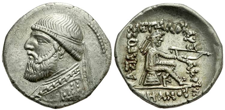
and finally your Sanatruk:
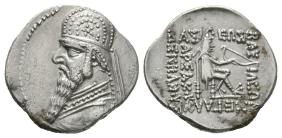
The evolution of the face is pretty obvious. You start with
- (1) a steppe nomad chieftain with his felt cap, then
- (2) a Hellenic king with a diadem a la Seleucids, then
- (3) a complex regal King of Kings crown, a throwback to the Achaemenids.
So the royal face evolves. But notice what doesn't evolve. The obverse. It is remains throughout a decidedly East Iranian steppe archer - cap, trousers, recurve bow. It is pretty much an advertisement of where Parthian power lies.
And it continues that way. While the royal image changes, they never dropped the archer.
So it seems the Parthians remained quite conscious of themselves and their roots. That they were and remained a steppe nomad elite superimposed on a Persian state. Their sculptures say that too, i.e. Mithradates governs on horseback:
If so, then you really want to give some thought to how this might change how they governed. You seem to interpret the Parthian state as much more centralized than it probably was. Steppe nomads have their own political structure - i.e. typically a confederation of "inner" tribes & "outer" tribes. It would be weird to abandon that loose structure in an instant to embrace some alien, centralized King of Kings thing. They may have a Persian bureaucracy underneath, but the military elite is still the elite, and they are bound by steppe rules. Thinking in confederation terms explain the powers of the Suren clan & other regional lords better.
Steppe rules also helps explain the breakdown & chaos. The system of succession in steppe nomads was lateral, not linear, i.e. the succession doesn't go to the eldest son, or even a son at all, but can go to brothers, uncles, cousins, etc. It is up to the inner Parthian clans to decide whom among the Arsacid family should succeed. If the clans agree, fine. If they don't agree, we got a problem. A very typical problem in any nomad confederacy - vide Huns, Mongols, etc. - and easily exploitable by an outsider (like Augustus).
So I think you're cutting it a little short by insinuating the Parthians forgot they were steppe nomads once they got hold of Iran, and were all instantly converted into a Persian King of Kings & satraps in some grand collective act of nostalgia. The bureaucracy may have been nostalgic and pushed the regalia. But it is likely the military elite dealt with each other by older steppe rules.
Not to take away from your excellent exposition. It just feels like you're not giving their steppe roots much emphasis in the politics.
I have a couple of questions on Part 3.6, when you talk about the breakdown. I am not sure you're revealing a sufficiently clear picture of the political situation. In particular, while you recognize the Parthian origins as steppe nomads, yet you seem to discuss the political situation as if they were conventional kings. But that may not be quite the right approach.
You only gave a small selection of coins. Start with Asarces I:
Then turn to Mithradates II:
and finally your Sanatruk:
The evolution of the face is pretty obvious. You start with
- (1) a steppe nomad chieftain with his felt cap, then
- (2) a Hellenic king with a diadem a la Seleucids, then
- (3) a complex regal King of Kings crown, a throwback to the Achaemenids.
So the royal face evolves. But notice what doesn't evolve. The obverse. It is remains throughout a decidedly East Iranian steppe archer - cap, trousers, recurve bow. It is pretty much an advertisement of where Parthian power lies.
And it continues that way. While the royal image changes, they never dropped the archer.
So it seems the Parthians remained quite conscious of themselves and their roots. That they were and remained a steppe nomad elite superimposed on a Persian state. Their sculptures say that too, i.e. Mithradates governs on horseback:
If so, then you really want to give some thought to how this might change how they governed. You seem to interpret the Parthian state as much more centralized than it probably was. Steppe nomads have their own political structure - i.e. typically a confederation of "inner" tribes & "outer" tribes. It would be weird to abandon that loose structure in an instant to embrace some alien, centralized King of Kings thing. They may have a Persian bureaucracy underneath, but the military elite is still the elite, and they are bound by steppe rules. Thinking in confederation terms explain the powers of the Suren clan & other regional lords better.
Steppe rules also helps explain the breakdown & chaos. The system of succession in steppe nomads was lateral, not linear, i.e. the succession doesn't go to the eldest son, or even a son at all, but can go to brothers, uncles, cousins, etc. It is up to the inner Parthian clans to decide whom among the Arsacid family should succeed. If the clans agree, fine. If they don't agree, we got a problem. A very typical problem in any nomad confederacy - vide Huns, Mongols, etc. - and easily exploitable by an outsider (like Augustus).
So I think you're cutting it a little short by insinuating the Parthians forgot they were steppe nomads once they got hold of Iran, and were all instantly converted into a Persian King of Kings & satraps in some grand collective act of nostalgia. The bureaucracy may have been nostalgic and pushed the regalia. But it is likely the military elite dealt with each other by older steppe rules.
Not to take away from your excellent exposition. It just feels like you're not giving their steppe roots much emphasis in the politics.
excellent posts! Very interesting and informative.
I have a few questions and a few points to raise though.
Firstly about the division of Iranian society into settled and nomadic populations. Where there long-standing ethnic or linguistic differences between the two groups (or three groups if we're talking about city-dwellers, hills people and desert nomads)? Or could nomads and agriculturalists speak the same language within each region? How separate were they? Was it a case of the two groups trying to dominate one another? Or a more cooperative relationship?
Ancient Middle Eastern societies, both in the Fertile Crescent and in Iran, were always mixed communities, and remained so until the XIX-XX centuries. Their relationship was usually cooperative; the nomads supplied the settled communities with meat, milk, wool, etc, and the settlers supplied the nomads with foodstuffs like grain. Also, in times of political trouble, the nomadic populations would profit from the disarray in settled communities to conduct razzias, and even to take power in them and become a dominant upper class (nomads were warrior societies, while settlers were not). There was also a degree of confusion between both societies, when due to epidemics or wars large plots of arable land became deserted, nomads would settle there and become farmers, and in cases of extreme drought or political trouble, settled families or whole communities could pack their things up and disappear into the desert, becoming nomads.
What was the nature of the nomad communities? Were they similar to the equestrian steppe nomads of the north (i.e. Scythians, Huns, Turks, Mongols, etc), i.e. a fiercely independent tribal society with a very warlike nature? Or are we talking more about simple sheep/goat herding groups?
That's a good and incisive question that's quite hard to answer. My own guess would be a mixture of both. And let's not forget that simple sheep/goat herding groups could be also quite bellicose, Iran was full of such groups, which were collectively known as Kurds, and included what would later become proper ethnical Kurds, Cadusians, Daylamites, Gilanis, etc. The Arsacids themselves entered the Iranian plateau from the northeast accompanied by Parni tribesmen, which were part of the Dahae confederation, which was a Scythic people. And later there would be the invasions of the Sakas (eastern Iranians) and the Tokharians/Yuezhi. Although the later two invasions were repelled with extreme difficulty, it's quite possible that groups of each nomadic wave remained within the Iranian plateau and retained their nomadic lifestyle and traditions.
What was their military power? What was their political power?
Did the cavalry armies of the Parthians and Sassanians come mostly from the equestrian nomads? Or from the estates of the landed-aristocracy/nobility? I'm trying to get an idea of whether we're talking about something like Turko-Mongol steppe tribe cavalry armies, or something more like the knights of medieval Europe (which required a large, settled farming economy to support them).
Did the nomads have their own nobility, or were the nobility entirely based around control of wealth and farming land? (were the nobles all descended from nomads who had conquered?)
Those are very good questions, and ones that have never been answered by scholars, probably because ancient sources never dealt with the issue. It was something so alien to Graeco-Roman society that probably they never even bothered to really understand it. My own guess (for what it's worth) is that the Arsacid nobility would be mostly of Parni descent, although they would have become "Parthianized" adopting the Iranian language of Parthia. They would have mixed with the nobility already existing in Iran (there's proof of marriages even with Greek families), but some areas seem to have retained intact their own pre-Arsacid nobility. The largest and most important of these areas was Pars in the south, which both the Seleucids and later the Arsacids left to be ruled by their own dynasties.
Notice that when I've described this society as "feudal" I've always used quotation marks, because the comparison, although useful to some degree, can also be misleading. First of all, the Arsacid (and later Sasanian) nobility was organized around clans, not families, and like among modern bedouins, they followed an agnatic succession principle. So, when imagining, let's say, the Suren, one should not thing of a medieval noble family like the counts of Toulouse or the dukes of Normandy, but something like the Saudi royal family, with its 4,000 members and with the mentality that the country belongs not to one amongst them, but to all of them, to the clan, in a collective way.
I'd say that the power of such clans would come from several sources. First, their own numbers, then, the number of their nomadic followers (being of nomadic origin, and retaining much of their original nomadic ethos, it's probable that they retained links with nomadic groups within the Iranian plateau), the control of large herds of cattle and horses, the control over parts of the sedentary population (which needed to be "protected" from the depredations of the nomads), and the control of fortresses and fortified towns and cities over key trade routes which allowed them to collect tolls.
To answer your question, I'd say that the "Parthian" nobility shared traits from both the Central Asian and medieval European upper classes.
For Sasanian Iran, tradition has left us the names of seven great "Parthian" clans. Of them, only two are clearly attested in Arsacid times, the Suren and Karin ones. The Suren appear to have been the most powerful clan, and to have retained most of the nomadic central Asian ways and mentality. There's also reason to believe that they were not of "pure" Parni/Parthian stock, but that they had interbreed with Sakas and even with the Indo-Greek dinasty of Kabul. The Karin, on the other way, seem to have been more "settled", with their main powerbase around Nehavand in Media, along with estates to the east in Parthia proper. The Karins would have been more invested in farming and collecting tolls from the Silk Road that ran through their lands, while the Suren in Sakastan seem to have been more devoted to herding and trying to expand eastwards from their homeland in Sakastan.
Demographics will be my next issue. I've researched the subject somewhat, but Iran is indeed a difficult place to understand. I've seen the figure of 4 to 5 million quoted for the pre-modern population, but I don't know how good that number is.
I agree with you that Maddison's demographic information may not be that great outside of Europe (he seems to always pick the lower-level possibilities, such as his frankly ridiculously low populations for the New World, prior to European contact). However, I have a hard time seeing how Iran could support a larger population in the 6th century than in the 19th.
Even though Iran was behind the West technologically by the 18th and 19th centuries, there was still surely significant new improvements in agriculture happen by that time. Iran must have received New World crops by that time, for instance (and indeed crops and varieties from Europe and elsewhere, due to the global trade network). So surely farming would be better, more productive and more sophisticated 200 or 300 years ago than it was 1,500 years ago, or 2,000 years ago. That would tend to suggest to me that the ancient and medieval populations couldn't have been as big as the 19th century population of the country.
Also, we should be a bit clearer with out definitions here. When you say the "Iranian plateau", do you mean basically the area of modern-day Iran? Or something larger, or smaller?
I agree with you that it's a thorny issue. I hesitated at including it in my posts, but finally I decided for it, knowing it would be a polemical issue, as it has indeed been. To answer your issue, the "Iranian plateau" includes all of the modern state of Iran, except for Iranian Azerbaijan, as well as parts of western Afghanistan (to use the excellent map quoted after your post, the ancient satrapies of Arachosia, Drangiana and Margiana).
Well there are some problems with this. Firstly we need to define what we mean by "Mesopotamia". Are you talking about the whole of modern Iraq? Or just the flat, river-fed plains of the Tigris and Euphrates? Do you include the Iraqi part of the Zagros mountains in this (i.e. Kurdistan)?
For Mesopotamia I don't mean the modern state of Iraq. I mean only the lands between the Euphrates and the Zagros, stopping at the feet of the mountains.
In any case, I'm not sure if it is directly comparable to Egypt. I think that Egypt is a really special case of a pre-modern society that had a very high population density, because of the almost unique fertility of the Nile valley. Just go look at some satellite images (Google Earth) of the farmland in Egypt and the farmland in Iraq or Iran, and you'll see a massive difference in how green and productive it is (Mesopotamia and Iran look quite arid by comparison).
Frankly I would expect both Mesopotamia and even the good parts of Iran to have less population density than Egypt.
Modern Iraq has 437,000 square kilometres (or km2) and I would roughly divide that area up into: ~240,000 km2 of desert (probably with only a small nomad population), about 100,000 km2 is "northern Iraq" or "Zagros Iraq", or just "Iraqi Kurdistan", which is mostly hills and mountains and smaller river valleys (and some flat desert). Which leaves about 97,000 km2 of farmland in and around the Tigris and Euphrates rivers. Though I'm not sure how extensive the irrigation systems were in the Middle Ages and whether the interior area between the main river-courses was irrigated and farmable, or whether it was arid (this will mater a lot as most of the current arable area is not close to the rivers).
Actually 97,000 km2 may be far too generous an area, I've done some more measurements and come to perhaps only 39,000 km2 for the irrigated, arable area of Mesopotamia. That's if you exclude some of the main region between the rivers (some of which is dry even today) and the southern area, which used to be a giant swamp until very recently. Frankly I don't think it's possible to have 4 to 5.5 million people on an area of 39,000 km2 (that's a population density of 103 to 141 p/km2, which is ridiculously high) with pre-modern technology.
From my studies it seems that generally Medieval farming methods would allow an agricultural society to have densities from anywhere between about 10 persons per square kilometre (or p/km2), to perhaps as high as 50 p/km2. There may be some exceptional cases, like Egypt where the numbers would go as high as 70 p/km2, but no more than that is really possible with pre-modern technology.
If the 39,000 km2 of Mesopotamia had a density of say 30 p/km2, then it would have 1.17 million people (30 p/km2 is a perfectly reasonable figure for a highly developed Mediaeval society, it's about what France had in the 1300s). If it had 50 p/km2, then we're talking 1.95 million and if it had 70 p/km2 (which is about what the Nile valley and delta had) then it could be as high as 2.73 million. I can't imagine it could go any higher than that.
There might be an additional 0.5 to 1 million people in northern Iraq (the Kurdish area), which would give Iraq a total population of maybe 2 to 3.5 million, at most.
As Tufto has noted in his post, the situation was not the same in ancient times. First of all, the area I've defined as Mesopotamia was divided into three clear parts. There was the northern Mesopotamian plain, where the two rivers are widely separated, and the terrain between them is slightly higher that the river valleys, with some small mountain ranges scattered here and there. This area was impossible to irrigate in ancient times, and is still today not irrigated. The only irrigable parts are the immediate vicinity of the Euphrates and Tigris, and some tributaries of the Euphrates from its eastern side, like the Khabur river. Other than that, the only cultivated areas are situated around desert oasis or springs, like at Hatra. The rest is desert or steppe, and in Arsacid and Sasanian times it was already roamed by nomadic Arabic tribes.
The second area is the land between the Tigris and the Zagros. This is the most naturally fertile land of the area, as it doesn't suffer from salinization and is watered by many mountain streams and rivers that flow from the Zagros into the Tigris. The most important among them are the Diyala, Great Zab and Lesser Zab rivers. Due to the fertility of this area, it was the main approach route to southern Mesopotamia used by Alexander the Great, Trajan and Heraclius.
And finally, there's central and southern Mesopotamia, where the two main rivers are much nearer to each other than in the north, and most importantly, the land between them is almost literally plain, with a medium incline of 1,5% or less towards the sea. In natural condition, the land between the rivers is an arid steppe. But due to geography, it's perfectly feasible to irrigate these lands, even with Bronze Age technology, and since the times of the Sumerians the lower Mesopotamian plain was crisscrossed by a dense network of irrigation channels that ran between both rivers and allowed most of the area to be irrigated. There's only one problem with this, that these lands are very prone to salinization, a process that has turned most of the lands totally unsuited for agriculture in modern times, and possibly for extended periods in ancient times also (although this has been disputed).
In the VI century, the Sasanians built massive hydraulic works in this area, especially the Nahrawan canal, that was later abandoned in Islamic times.
Hmm, I can't accept such a high figure for this area. Assuming by "Elymais" you mean roughly modern Khuzestan province, then I don't see how 1.5 to 2 million people could live there in the Early Middle Ages. If you are talking about a larger area than modern Khuzestan (such as including parts of Southern Iraq or something), then what I'm about to say may not apply, but here goes anyway.
I measured the area of farmland within Khuzestan, which is all located along a few river valleys/plains. And I came to a figure of about 16,500 square kilometres (or km2), which doesn't seem like enough to support such a large population. Although the total area of the province is 64,000 km2, most of that is very arid mountains and hills, which seem unlikely to support a major population (I'm sure there are scattered villages and nomads all over the place, but not dense agricultural settlements or cities). If I'm generous and increase the amount of farmland to say 18,000 km2, to account for all the little bits of arable and semi-arable land up in the mountains, that still isn't much.
Now if we calculate a population density for this area we can get somewhere.
If those ~18,000 km2 of arable land have a density of 10 p/km2, then it has a population of 180,000 people. If 20 p/km2 then 360,000, if 30 p/km2 then 540,000. If they had very high densities of 50 p/km2, then they would have 900,000 people. I don't see how it could be possible to support 1.5 to 2 million people though (that would suggest densities of 83 p/km2 and 111 p/km2, respectively, which is just too high). Now of course there are still going to be some people living in the remaining ~46,000 km2 area of the province, but since the climate is so harsh and the terrain so difficult I can only imagine that small numbers of nomads could live there, at a low population density.
Again, from my research, I determined that generally the population density of nomadic societies cannot go above 1 p/km2 and in many cases (like desert or arctic nomads) their density may be much less than that (I came to some general conclusions of about 0.5 p/km2 for steppe nomads, 0.2 to 0.1 p/km2 for desert nomads and 0.05 to 0.01 for arctic nomads). If the remaining 46,000 km2 of Khuzestan had say 1 p/km2, then it would only account for less than 50,000 people, which is a rounding error when considering the size of the settled agricultural population (almost an irrelevance when talking about the demography).
(you can read this post of mine, from a few months ago [and the following posts] to get an idea of the framework I'm using to calculate populations and some of my basic assumptions about pre-modern population density)
Here's an image from Google Earth where I've measured the areas of farmland in red:
(note that the large dark green area between the two main red areas is a swamp of some sort. You can see the Iraqi border in yellow and the Khuzestan province borders in light purple. I assumed that the last few kilometres of the river deltas are alluvial deposits which would not have existed yet by 2 millennia ago, as they get bigger gradually and the sea would have been further in-land back then. The red areas make up only about 25% of the province)
My guess is that Khuzestan in the Middle Ages would have only around 0.5 to 1 million people, but it would struggle to get higher than that.
I agree that for the Arsacid era Elymais/Khuzestan would be a disputed issue, but again bear in mind that starting with Shapur I, the Sasanians built massive irrigation projects in the area, introduced new crops (like rice and sugar cane from India) and population surged spectacularly, with the area becoming perhaps the most urbanized part of the empire, together with central Mesopotamia. During the Caliphate, it was still known as "the breadbasket of the Caliphate".
What area exactly are you talking about here for "Arsacid Armenia"? How big is it? and can you show a map of the area you mean (I assume it's significantly bigger than modern-day Armenia?). Modern Armenia (then a Soviet republic) only had a population of 1.35 million in 1950 (according to UN data), so I can only assume it had a much smaller population in the Middle Ages (often, counties increased their population 5 or 10-fold from the Medieval era to the Modern era). For 2 to 2.5 million you must be talking about a large section of (modern-day) Turkey as well.
Yes, it was an area several times larger than modern-day Armenia:

Hmm, Azerbaijan (the then Soviet republic) had a population of 2.9 million by 1950 (and that doesn't include any of Iranian Azerbaijan, which I don't have any historic data for). And it is a much less arid region than most of Iran or Iraq, so you may be underestimating its population (especially if you include all of Iranian Azerbaijan in that figure).
I would perhaps conclude a figure closer to the low end of that estimate (though it depends, as I'm not fully sure of the exact areas you're talking about). Maybe 7 million at a push.
Fair enough
Great pictures, but Mike Loades is English, for your information.
I stand corrected, then
Last edited:
Hey, just thinking about this topic made me look up some old maps and diagrams, so some of you may also be interested in them:
Here's a map of the Satrapies of the Achaemenid Persian Empire, though I don't know if they are in any way similar to the Parthian and Sassanian periods.
And here's a useful diagram of the Iranian/Iranic languages (past and present):
The map of the ancient Achaemenid satrapies can be useful for the thread in that Graeco-Roman authors almost always used these ancient and archaic terms to refer to the different lands of the Arsacid and Sasanian empires. Some of the old Achaemenid satrapies were even retained in order to refer to large geographical areas (Persis, Media, Parthia, etc) but for the Arsacid era, we lack data to ascertain which were the precise administrative divisions of the empire.
We know that Arsacids mostly kept using the Seleucid administrative divisions, and that the Seleucids in turn had kept the Achaemenid ones. The problem is that our knowledge of Achaemenid satrapies derives mostly from Herodotus; but contemporary scholars have detected many discrepancies between Herodotus’ list and other surviving evidence (in Aramaic, Old Persian, Greek, etc.).
As the text that accompanies the map says, the current consensus amongst scholars is that the Achaemenid system of satrapies was a three tier system, with satrapies of first order than were subdivided into satrapies of second order which were in turn subdivided into satrapies of third order.
As for the tree of Iranian languages, notice also the position in it of the main languages that will be quoted during this thread:
- Middle and New Persian are southwestern Iranian languages.
- Scythian (a dialect of which was probably the original language of the Parni) was a northeastern Iranian language.
- Parthian was a northwestern Iranian language, very close to Median.
- Bactrian was a northeastern Iranian language, that became the main administrative language of the Kushan empire. It was written using a slightly modified version of the Greek alphabet. Recently, a great number of parchment documents written in Bactrian dating from the Hephtalite and late Sasanian era have surfaced through antiquities dealers in Pakistan, which have allowed scholars to learn a lot about daily life and economic, administrative and political relationships in Bactria just before the Islamic conquest. In Sasanian documents, Bactria is always called “Tokharistan”.
- Soghdian was also a northeastern Iranian language, spoken in ancient Soghdiana (the land between the Amu Darya and Syr Darya rivers in Central Asia.
Last edited:
Threadmarks
View all 68 threadmarks
Reader mode
Reader mode