Hello there!
It's been a while, but I'm once again posting a suggestion for Europe. This time Hungary has come to my attention.
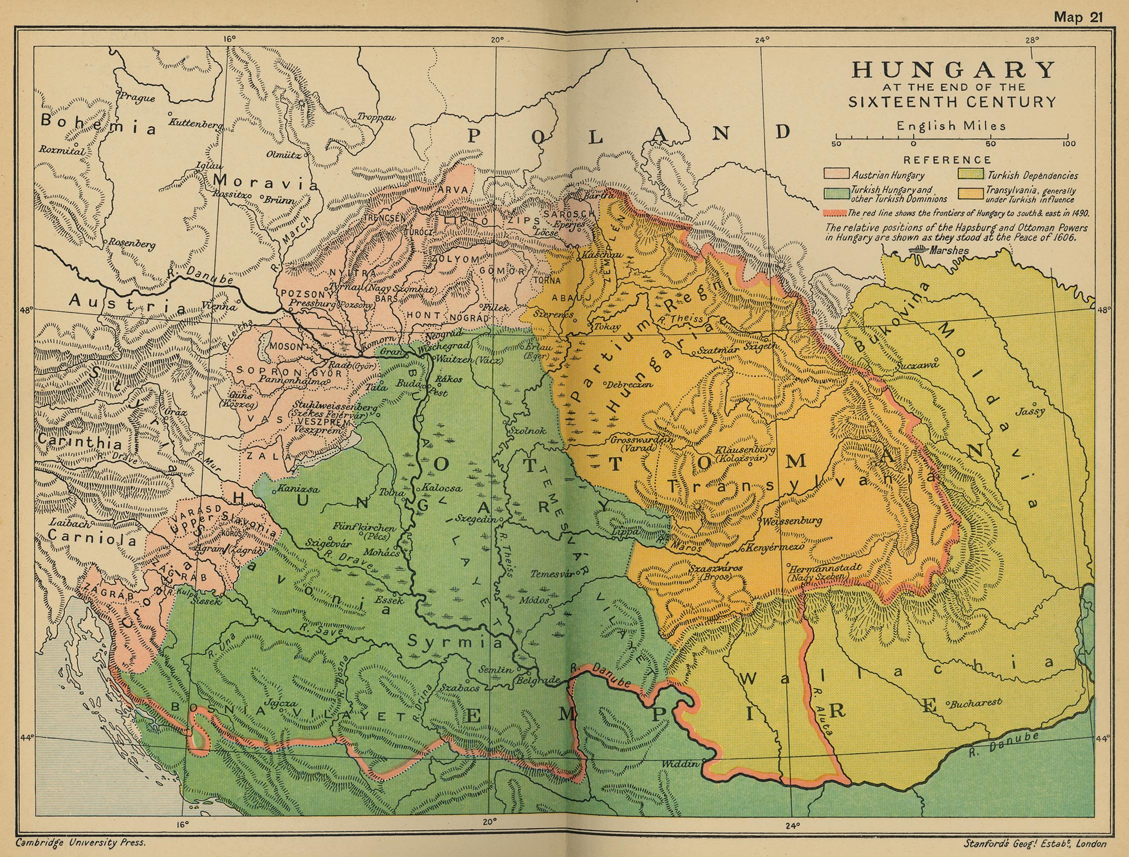
The beginning of the EU4 timeline can be seen as the rise (and subsequent fall) of the great Kingdom of Hungary; It had a sizable population, wealth, a professional standing army and competent leadership. All in all quite the powerhouse matching the rising power of the Habsburgs and the Ottomans. EU4 has had a Hungarian update somewhere around 2017, but that one still has many flaws compared to the newly updated regions:
- Province/county- and city-shuffling; Wrong capitals assigned to provinces.
- Huge, blocky provinces.
- Lacking strategic and historical depth.
- A kind of anachronistic 'Eastbloc' feel to it; Less developed than in reality.
- A lot of wrong/misplaced dynamic province-names.
So, the challenge for me was to solve those problems as best as I could, as well as the following aspects:
- Highlighting the importance of the more highly populated regions of the Hungarian plains.
- Adding historically important towns and counties to the Transylvanian regions and looking at its borders.
- Adding to the economically important mining towns of Slovakia.
- Keeping the borders dynamic enough to make them roughly fit a historical partition between Austria, the Ottomans and Transylvania (or other hypothetical powers).
- Choosing the best and most fitting counties, as not every one of them fits, obviously.
- The Danube and other Balkan Rivers are slightly off, this makes it difficult to pinpoint provinces/cities exactly. It's probably because of map-projection. Other parts of Eastern Europe suffer from the same issue.
A suggestion which comes very close to my own vision is the one made by @Entrone (https://forum.paradoxplaza.com/forum/threads/hungary-update.1191609/. My work can be seen as somewhat of a slight revision of his (and other people's) work.
Update to Hungary and Transylvania:

List of provinces (and capitals):
1: Pozsony: Pozsony, took a bit from Wien. The city (and county) of Pressburg obviously + the upper bits of Nyitra. Its Slovakian dynamic name (Nitra) should go to Nyitra.
2: Nyitra: Nyitra. a new province born from the combination of the Nyitra and Bars counties. Nyitra being the more important one.
3: Trencsén: Trencsén, some slight edits in size and city-placement. It's a combination of the Trencsén, Árva, Turoc and Liptó counties.
4: Zólyom: Besztercebánya, a new province, a big combination of the county (and EU4-province) of Hont, as well as Nógrád, Zólyom, Gömör and Kishont. The location of many important mining towns, Besztercebánya was the region's most important and wealthy city. Even though Zvolen Castle was the county-seat for a while, cities>castles. Hont was 'just' a castle as well, so it doesn't exist on this setup anymore, now split between Zólyom and Nyitra.
5: Szepes: Lőcse, the old Szepes province, but trimmed a bit. Also with a new and fitting capital city instead of the castle of Spis. It's the combination of the counties of Szepes and Sáros.
6: Kassa: Kassa. Zemplén and Abaúj combined. I'm a bit reluctant to name the province Abaúj, as most of it is made of Zemplén's territory. Kassa was also important enough to warrant its own name on the map. So, first one that isn't named after a county.
7: Bereg: Beregszász, a new province. A combination of the Bereg and Ung counties, with Bereg's county-seat as capital.
8: Sopron: Sopron, slightly changed its borders and split it in two to make way for the next province. Numerous villages and towns around Sopron quickly came under Habsburg control after 1444, hence its borders.
9: Vas: Szombathely, a new province born from the split of Sopron. An old Roman town situated in the county of Vas, quite sizable.
10: Esztergom: Esztergom, the prominent archbishopric of the same name was seated here. A combination of the Györ, Komárom and Esztergom counties.
11: Fejér: Fehérvár, slightly changed its borders to make it more accurate and room for Esztergom. A combination of the Veszprém and Fejér counties.
12: Somogy: Kaposvár, only slightly changed its borders (to the south as well). A combination of the counties of Somogy, Tolna and bits of Baranya.
13: Pest: Buda, the capital, greatly reduced its size to make it slightly harder to reach and to make room for new provinces. It's now a bit more historically sized; A combination of the county of Pest, small bits of Fejér and Pilis.
14: Szolnok: Szolnok, central Hungary is a mix of different small and/or elongated counties, so this one had to be centered around the most important town in the vicinity; Szolnok. Which already existed in EU4, but was quite misplaced, to put it mildly. The province is a combination of the semi-autonomous Kunság region, as well as Szolnok itself and parts of Csongrád and the old province of Békés (which has gone the way of the dodo, together with its capital of Gyula).
15: Heves: Eger, already was in EU4 (kind of), as the Ottoman name for the Szolnok-province (which is obviously incorrect). Renowned for its defiance against the Turks, this city (and county) are now on the map. The province is a combination of the Heves and Borsod counties.
16: Szeged: Szeged, a new province centered around the important city of Szeged. Although it's the county-seat of Csongrád, this county is too elongated to fit one province. That's why parts of it lay in the Szolnok-province and why it has Szeged as its name, instead of Csongrád. Most of its territory is part of the Csanád county, and bits of Békés. Both were too minor to add on their own.
17: Bács: Bács, its city has been placed on the correct spot and its borders trimmed to make way for Szeged. It covers the Bács and Bodrog counties, as well as a small bit of Csongrád.
18: Debrecen: Debrecen, the old Szabolcs province (which had Debrecen as capital). The capital of the Szabolcs-county was still as big as a village and not noteworty enough until the 18th century, Debrecen was actually a part of the Bihar-county. That's why I renamed this province to Debrecen. So, a mix of the Szabolcs-county as well as a small part of Bihar which contains Debrecen.
19: Szatmár: Szatmárnémeti, a new province covering the Szatmár-county and small bits of Közep-Szolnok.
20: Bihar: Nagyvárad, Oradea has been renamed to Nagyvárad (the Hungarian name for the same city). Its shape has been altered a bit, as it has lost Debrecen and gained parts of the little counties of Kraszna and Kozép-Szolnok (which has been split between Bihar and Szatmár).
21: Arad: Arad, a new province made from the combination of the counties of Arad and Zaránd.
22: Temes: Temesvár, changed its borders a bit, as well as the location of the town of Temesvár. Its a combination of the counties of Temes and Krassó.
23: Torontál: Nagybecskerek, cut its borders a bit to make it more historical. It's a combination of the counties of Keve and Torontál.
24: Szerém: Mitrovica slightly changed the placement of the city, nothing major.
25: Nándorfehérvár: Nándorfehérvár, kept it as it is.
26: Hunyad: Vajdahunyad, it now has the correct capital, instead of the city of Alba Iulia (Gyulafehérvár). Vajdahunyad also held the seat of the Hunyadi family, a beautiful castle. Changed its borders a bit, as well.
27: Fehér: Gyulafehérvár, finally a province on its own; the capital of the Principality of Transylvania, Alba Iulia (in Romanian) or Weissenburg (in German).
28: Szeben: Nagyszeben, the old province of Királyföld has been split in two to make way for two of the more famous Saxon cities of Transylvania; Sibiu (Szeben), which was the capital of the old Kiralýföld province, and Brasov (Brassó). Has parts of the Fogaras county.
29: Brassó: Brassó, a new province split from Királyföld. Has parts of the Fogaras county.
30: Székelyföld: Marosvásárhely, Targu Mures has been renamed to its Hungarian version (Marosvásárhely) and the province renamed to the historical region of the Székely people: the Székelyföld, as Maros was only a small bit of this province.
31: Kolozs: Kolozsvár, Cluj (Romanian) or Klausenburg (German) is now finally on the map; the old province of Torda was less important and is now fused in it, as well. It obviously has salt as tradegood, because of the Torda mines.
32: Beszterce: Beszterce, another new province. A Saxon town and important marketplace in the region. It has routes into the Carpathian mountains, hence the new mountainpass.
33: Máramaros: Máramarossziget, slightly changed its borders and has gotten a new capital city, which was the actual seat of the historical county during this period of time.
Sources for maps:
- https://cdn.discordapp.com/attachme...mortgages_between_15th_and_17th_centuries.jpg
- https://i.redd.it/6u11geevac341.png
- https://slideplayer.hu/slide/2622666/9/images/41/Nemesi+vármegyerendszer.jpg
- https://upload.wikimedia.org/wikipedia/commons/1/17/Transylvanian_Principality.svg
- https://upload.wikimedia.org/wikipedia/commons/b/b7/Siebenbürgen_1300-1867.jpg
- https://upload.wikimedia.org/wikipedia/commons/b/b7/Siebenbürgen_1300-1867.jpg
Tradegoods:

Areas:

Light green: Upper Hungary
Light orange: Subcarpathia
Dark orange: Transdanubia
Light blue: Northern Alföld
Dark blue: Southern Alföld
Green: Partium/Részek
Turquoise: Northern Transylvania
Blue-grey: Southern Transylvania
Dynamic province-names: Soon
The old work-in-progress version painted on the EU4-map:
.png "Hungary Update (with borders).png")
This one might be more clear on where the borders are on the EU4 map, keep in mind though that some changed have been made.
It's been a while, but I'm once again posting a suggestion for Europe. This time Hungary has come to my attention.
The beginning of the EU4 timeline can be seen as the rise (and subsequent fall) of the great Kingdom of Hungary; It had a sizable population, wealth, a professional standing army and competent leadership. All in all quite the powerhouse matching the rising power of the Habsburgs and the Ottomans. EU4 has had a Hungarian update somewhere around 2017, but that one still has many flaws compared to the newly updated regions:
- Province/county- and city-shuffling; Wrong capitals assigned to provinces.
- Huge, blocky provinces.
- Lacking strategic and historical depth.
- A kind of anachronistic 'Eastbloc' feel to it; Less developed than in reality.
- A lot of wrong/misplaced dynamic province-names.
So, the challenge for me was to solve those problems as best as I could, as well as the following aspects:
- Highlighting the importance of the more highly populated regions of the Hungarian plains.
- Adding historically important towns and counties to the Transylvanian regions and looking at its borders.
- Adding to the economically important mining towns of Slovakia.
- Keeping the borders dynamic enough to make them roughly fit a historical partition between Austria, the Ottomans and Transylvania (or other hypothetical powers).
- Choosing the best and most fitting counties, as not every one of them fits, obviously.
- The Danube and other Balkan Rivers are slightly off, this makes it difficult to pinpoint provinces/cities exactly. It's probably because of map-projection. Other parts of Eastern Europe suffer from the same issue.
A suggestion which comes very close to my own vision is the one made by @Entrone (https://forum.paradoxplaza.com/forum/threads/hungary-update.1191609/. My work can be seen as somewhat of a slight revision of his (and other people's) work.
Update to Hungary and Transylvania:
List of provinces (and capitals):
1: Pozsony: Pozsony, took a bit from Wien. The city (and county) of Pressburg obviously + the upper bits of Nyitra. Its Slovakian dynamic name (Nitra) should go to Nyitra.
2: Nyitra: Nyitra. a new province born from the combination of the Nyitra and Bars counties. Nyitra being the more important one.
3: Trencsén: Trencsén, some slight edits in size and city-placement. It's a combination of the Trencsén, Árva, Turoc and Liptó counties.
4: Zólyom: Besztercebánya, a new province, a big combination of the county (and EU4-province) of Hont, as well as Nógrád, Zólyom, Gömör and Kishont. The location of many important mining towns, Besztercebánya was the region's most important and wealthy city. Even though Zvolen Castle was the county-seat for a while, cities>castles. Hont was 'just' a castle as well, so it doesn't exist on this setup anymore, now split between Zólyom and Nyitra.
5: Szepes: Lőcse, the old Szepes province, but trimmed a bit. Also with a new and fitting capital city instead of the castle of Spis. It's the combination of the counties of Szepes and Sáros.
6: Kassa: Kassa. Zemplén and Abaúj combined. I'm a bit reluctant to name the province Abaúj, as most of it is made of Zemplén's territory. Kassa was also important enough to warrant its own name on the map. So, first one that isn't named after a county.
7: Bereg: Beregszász, a new province. A combination of the Bereg and Ung counties, with Bereg's county-seat as capital.
8: Sopron: Sopron, slightly changed its borders and split it in two to make way for the next province. Numerous villages and towns around Sopron quickly came under Habsburg control after 1444, hence its borders.
9: Vas: Szombathely, a new province born from the split of Sopron. An old Roman town situated in the county of Vas, quite sizable.
10: Esztergom: Esztergom, the prominent archbishopric of the same name was seated here. A combination of the Györ, Komárom and Esztergom counties.
11: Fejér: Fehérvár, slightly changed its borders to make it more accurate and room for Esztergom. A combination of the Veszprém and Fejér counties.
12: Somogy: Kaposvár, only slightly changed its borders (to the south as well). A combination of the counties of Somogy, Tolna and bits of Baranya.
13: Pest: Buda, the capital, greatly reduced its size to make it slightly harder to reach and to make room for new provinces. It's now a bit more historically sized; A combination of the county of Pest, small bits of Fejér and Pilis.
14: Szolnok: Szolnok, central Hungary is a mix of different small and/or elongated counties, so this one had to be centered around the most important town in the vicinity; Szolnok. Which already existed in EU4, but was quite misplaced, to put it mildly. The province is a combination of the semi-autonomous Kunság region, as well as Szolnok itself and parts of Csongrád and the old province of Békés (which has gone the way of the dodo, together with its capital of Gyula).
15: Heves: Eger, already was in EU4 (kind of), as the Ottoman name for the Szolnok-province (which is obviously incorrect). Renowned for its defiance against the Turks, this city (and county) are now on the map. The province is a combination of the Heves and Borsod counties.
16: Szeged: Szeged, a new province centered around the important city of Szeged. Although it's the county-seat of Csongrád, this county is too elongated to fit one province. That's why parts of it lay in the Szolnok-province and why it has Szeged as its name, instead of Csongrád. Most of its territory is part of the Csanád county, and bits of Békés. Both were too minor to add on their own.
17: Bács: Bács, its city has been placed on the correct spot and its borders trimmed to make way for Szeged. It covers the Bács and Bodrog counties, as well as a small bit of Csongrád.
18: Debrecen: Debrecen, the old Szabolcs province (which had Debrecen as capital). The capital of the Szabolcs-county was still as big as a village and not noteworty enough until the 18th century, Debrecen was actually a part of the Bihar-county. That's why I renamed this province to Debrecen. So, a mix of the Szabolcs-county as well as a small part of Bihar which contains Debrecen.
19: Szatmár: Szatmárnémeti, a new province covering the Szatmár-county and small bits of Közep-Szolnok.
20: Bihar: Nagyvárad, Oradea has been renamed to Nagyvárad (the Hungarian name for the same city). Its shape has been altered a bit, as it has lost Debrecen and gained parts of the little counties of Kraszna and Kozép-Szolnok (which has been split between Bihar and Szatmár).
21: Arad: Arad, a new province made from the combination of the counties of Arad and Zaránd.
22: Temes: Temesvár, changed its borders a bit, as well as the location of the town of Temesvár. Its a combination of the counties of Temes and Krassó.
23: Torontál: Nagybecskerek, cut its borders a bit to make it more historical. It's a combination of the counties of Keve and Torontál.
24: Szerém: Mitrovica slightly changed the placement of the city, nothing major.
25: Nándorfehérvár: Nándorfehérvár, kept it as it is.
26: Hunyad: Vajdahunyad, it now has the correct capital, instead of the city of Alba Iulia (Gyulafehérvár). Vajdahunyad also held the seat of the Hunyadi family, a beautiful castle. Changed its borders a bit, as well.
27: Fehér: Gyulafehérvár, finally a province on its own; the capital of the Principality of Transylvania, Alba Iulia (in Romanian) or Weissenburg (in German).
28: Szeben: Nagyszeben, the old province of Királyföld has been split in two to make way for two of the more famous Saxon cities of Transylvania; Sibiu (Szeben), which was the capital of the old Kiralýföld province, and Brasov (Brassó). Has parts of the Fogaras county.
29: Brassó: Brassó, a new province split from Királyföld. Has parts of the Fogaras county.
30: Székelyföld: Marosvásárhely, Targu Mures has been renamed to its Hungarian version (Marosvásárhely) and the province renamed to the historical region of the Székely people: the Székelyföld, as Maros was only a small bit of this province.
31: Kolozs: Kolozsvár, Cluj (Romanian) or Klausenburg (German) is now finally on the map; the old province of Torda was less important and is now fused in it, as well. It obviously has salt as tradegood, because of the Torda mines.
32: Beszterce: Beszterce, another new province. A Saxon town and important marketplace in the region. It has routes into the Carpathian mountains, hence the new mountainpass.
33: Máramaros: Máramarossziget, slightly changed its borders and has gotten a new capital city, which was the actual seat of the historical county during this period of time.
Sources for maps:
- https://cdn.discordapp.com/attachme...mortgages_between_15th_and_17th_centuries.jpg
- https://i.redd.it/6u11geevac341.png
- https://slideplayer.hu/slide/2622666/9/images/41/Nemesi+vármegyerendszer.jpg
- https://upload.wikimedia.org/wikipedia/commons/1/17/Transylvanian_Principality.svg
- https://upload.wikimedia.org/wikipedia/commons/b/b7/Siebenbürgen_1300-1867.jpg
- https://upload.wikimedia.org/wikipedia/commons/b/b7/Siebenbürgen_1300-1867.jpg
Tradegoods:
Upper Hungary (Slovakia):
- Three mining regions, because this region was known for its mining towns. Most of them were even part of the Fugger family business; The silver mines of Banska Stiavnica (gold tradegood for the Nyitra-province), the various mining towns (like Banska Bystrica) located in the new Zólyom-province (copper was the main tradegood) and finally the coppermines of Spisska Nova Ves in the Szepes-province. I couldn't find a good reason to keep the iron tradegood in the Trencsin-province. Mining efforts in the Tatra mountains usually resulted in failure.
- More mountainous regions with pastural grounds, like Bereg and Trencsin, have received the wool-tradegood, while the flatter parts (Kassa and Pozsony) have received the grain tradegood.
Hungary (Alföld and Transdanubia):
- An extra wine-region has been added, the basegame only had 1.
- The most dominant tradegood should be cattle, as this was the main export of the Hungarian kingdom, especially for the Alföld region.
- Other parts, like the fertile Banat-plains and other flatlands, have received the grain-tradegood. Slightly less numerous than the cattle-tradegood.
- More rugged parts have once again been given the wool-tradegood.
- Belgrade keeps its textile-tradegood.
Transylvania:
- SALT. Salt. Very important; 3 Saltmines, to be exact. The most famous one, the Torda salt mine, is now located in the Cluj province (Kolozsvár). The Praid salt mine (saw the most use in the 18th century) to the east of Targu Mures (Marosvásárhely) and finally the Solotyvno saltmine just to the north of Máramarossziget.
- The important Saxon cities have been given textile-tradegoods, as their guilds produced and traded in fabrics. Brassó has been given the wool-tradegood, as three cloth-producing provinces next to each other would've been a bit too much. Wool also represents the pastoralists living in the mountains.
- Hunyad had iron mines and thus retains its iron tradegood.
- Transylvania misses an agricultural tradegood, hence why one of its wineregions was incorporated (used since the first Saxons settled here) in the new Beszterce province.
Light green: Upper Hungary
Light orange: Subcarpathia
Dark orange: Transdanubia
Light blue: Northern Alföld
Dark blue: Southern Alföld
Green: Partium/Részek
Turquoise: Northern Transylvania
Blue-grey: Southern Transylvania
The old work-in-progress version painted on the EU4-map:
This one might be more clear on where the borders are on the EU4 map, keep in mind though that some changed have been made.
Last edited:
- 10
- 4

- 2
- 1