• We have updated our Community Code of Conduct. Please read through the new rules for the forum that are an integral part of Paradox Interactive’s User Agreement.

unmerged(47162)

Missing my avatar
Aug 4, 2005
7.251
20
Lets hope I complete this one eh? :p

Index

Geography
Jamestown
Start to Colonize New England
The Voyage to Plymouth

For anonymous4401 or LM+


[*b], New England, [*/b] -, [url*=, http://forum.paradoxplaza.com/forum/showthread.php?p=5134067#post5134067, ], The Precise History of New England, [/*url], by, Lifeless, Timespan 1920-1946, Status Ongoing, First Post Mar 10 2006, Last Update May 26 2006
 
Last edited:
usamap1cs.gif


Maine

Maine consists largely of a coastal plain of eroded valleys, with more resistant rock forming the generally mountainous west. Mt. Katahdin (5,268 ft/1,606 m) is the highest point in the state. Ninety percent of the land is forest including great stands of white pine, hemlock, spruce, fir, and hardwoods, which would inhibit population later. Caused by receding glaciers, there are more than 2200 lakes and more than 5000 streams and rivers. The coast is filled with jagged rocks and cliffs and thousands of bays and inlets. The major rivers include the St. John, the Penobscot, the Kennebec, the Androscoggin, and the Saco.

Connecticut

The highest peak in Connecticut is Bear Mountain in Salisbury in the northwest corner of the state, however, it is not the highest point. The state, although small, has regional variations in its landscape and culture from Fairfield County's to the rolling mountains and farms of the Litchfield Hills and Southeastern Connecticut. The Connecticut River, which flows through only the northern half of this lowland, veers off to the southeast in central Connecticut. In the south along Long Island Sound is a low, rolling coastal plain. The western highland, with the Taconic Mts. and the Litchfield Hills, is more rugged than the eastern highland.

Massachusetts

The eastern part Massachusetts, including the Cape Cod peninsula and the islands lying off it to the south—the Elizabeth Islands, Martha's Vineyard, and Nantucket—is a low coastal plain. In the interior rise uplands separated by the rich Connecticut River valley, and farther west lays the Berkshire valley, surrounded by the Berkshire Hills, part of the Taconic Mts. Mt. Greylock in the Berkshires is the highest point (3,491 ft/1,064 m).

New Hampshire

New Hampshire's major regions are the Great North Woods, the White Mountains, the Lakes Region the Seacoast, the Merrimack Valley, the Monadnock Region, and the Dartmouth-Lake Sunapee area. The White Mountains range in New Hampshire spans the north-central portion of the state, with Mount Washington being the tallest in New England, and other mountains like Mount Madison and Mount Quincy Adams surrounding it. Major rivers include the 110-mile Merrimack River, which bisects the lower half of the state north-south and ends up in Massachusetts

Rhode Island

The mean elevation of the state is 200 ft. Narragansett Bay is a major feature of the state's topography. Block Island, known for its beaches, lies approximately 12 miles off the southern coast of the mainland. Within the Bay, there are over 30 islands the largest being Aquidneck Island. Rhode Island's highest natural point is Jerimoth Hill, only 812 feet (247 m) above sea level.

Vermont

The west bank of the Connecticut River marks the eastern border of the state with New Hampshire (the river itself is part of New Hampshire). Lake Champlain is the major lake in Vermont while Mount Mansfield is the highest mountain in the state.

New York

New York’s border touch two Great Lakes, the Eire and Ontario. The Hudson River begins with Lake Tear of the Clouds and flows south through the eastern part of the state without draining Lakes George or Champlain. Lake George empties at its north end into Lake Champlain, whose northern end extends into Canada, where it drains into the Richelieu and then the St Lawrence Rivers. Mt. Marcy (5,344 ft/1,629 m), the highest point in the state, is near Lake Placid. Most of the southern part of the state is on the Allegheny plateau, which rises in the SE to the Catskill Mts.

New Jersey

New Jersey is surrounded by water except along the 50 mi (80 km) of northern border with New York State. The northern third of the state lies within the Appalachian Highland region, where ridges running northeast and southwest shelter valleys containing pleasant streams and glacial lakes. The Kittatinny Mts., with the state's highest elevations (up to 1,803 ft/550 m), stretches across the northwest corner of New Jersey from the New York border to the Delaware Water Gap. Southeast of the Highlands lie the Triassic lowlands or piedmont plains. . Offshore barrier islands make large harbors impractical but provide 115 mi (185 km) of sheltered waterways that have made possible a superior combination of bay and ocean facilities. Inland from the coast laid the Pine Barrens, a vast area of forests, small rivers, and few settlements.


martimesmap7wy.jpg


New Brunswick

New Brunswick is bounded on the north by Quebec's Gaspé Peninsula and Chaleur Bay and on the east by the Gulf of Saint Lawrence and Northumberland Strait. To the south, the narrow Isthmus of Chignecto connects it to peninsular Nova Scotia, most of which is separated from the mainland by the Bay of Fundy. There are several major river systems in the province including the St. John River, Petitcodiac River, Miramichi River, St. Croix River and the Restigouche River.

Nova Scotia

The province's mainland is a peninsula, connected to mainland North America by the Isthmus of Chignecto, and surrounded by the Atlantic Ocean, including numerous bays and estuaries. Rivers include the Magaree River, the Aspy River, Mira River, and the Noel River.

Prince Edwards Island

The island is located in the Gulf of Saint Lawrence, east of New Brunswick and north of Nova Scotia from which it is separated by the Northumberland Strait. The coastline of the island consists of a combination of long beaches, dunes, short sandstone cliffs, salt water marshes and numerous small bays and harbors. Large dune fields on the north shore can be found on barrier islands at the entrances to various bays and harbors.
 
okay, my interest has been picqued.
 
Jamestown

In 1606 James I charted a pair of English joint stock companies that were known as the Virginia Company. The two companies were called the Virginia Company of London or the London Company and the Virginia Company of Plymouth or Plymouth Company. Both were assigned the task of establishing colonies on the North American coast to increase English influence over the land and to rival the Spanish Empire already established in the Americas. In April of 1607, 105 colonists arrived in the new world, four months after leaving England in three ships, the Susan Constant, Godspeed, and Discovery.

jamestownships7hk.jpg


They proceeded to sail up the Chesapeake Bay to Hampton Roads and finally up the James River. Soon they arrived at an island of swampland, naming the site Jamestown after King James making it the first permanent English settlement in the North American continent. Despite the swampland, the settlers chose the location for the colony for several reasons. One, it was easily defendable and it was far enough inland to avoid contact and conflict with the Spanish fleet, while the river was deep enough to permit them to anchor their ships, yet have an easy and quick departure if necessary and two, it had excellent visibility up and down the James River allowing the colonists time to mount a defense if needed.

jamestownswamp2iv.jpg


On May 26, Paspahegh Native Americans attacked the settlement, killing one of the settlers and wounded eleven more. By June 15, the settlers had finished building the triangle fort, protecting the settlers from hostile Native Americans.

jamestownfort3xw.jpg

An artist rendition of the fort

Edward Maria Wingfield was soon elected president of Jamestown but was soon abdicated for suspicion that he was friendly toward Spain. He was replaced by John Ratcliffe, the captain of the Discovery.

wingfield1dg.jpg

Wingfield, the first President of Jamestown

After a year however, John Smith was elected to replace him. It is said that it was his determination that kept the colony together and not dissolving and going back to England. The colonists, who hoped to find gold, neglected farming and paid the consequences as disease from contaminated river water stuck them which was followed closely by hunger. Smith however, “encouraged” or rather forced the colonists to farm after saying "He who does not work, will not eat.”

johnsmith1at.gif

John Smith the savior of Jamestown?

Later, Smith was injured when his powder bag exploded, and was sent back to England never to return to Virginia. In his absence and likewise without his leadership, the settlement deteriorated. After Smith returned to England, Ratcliffe became President again only to be captured by Chief Powhatan while on a trade mission shortly after being elected and killed, the already tense standoff between the colonists and the Native Americans escalating into all out war with the Powhatans trying to evict the colonists however, these attempts invited strong reprisals from the English, resulting in the destruction of the tribe. The "starving time" winter followed Smith's departure in 1609 during which only 60 of the original 214 settlers at Jamestown survived. The survivors decided to abandon the fort and it was only the arrival of a new governor, Lord De La Ware, and his supply ships that brought the colonists back to the fort and the colony back on its feet. In 1622 however, the King revoked the Virginia Company Charter following an attack on the colony by the Algonquians which killed over 300 colonists in the out plantations and mismanagement of the Virginia Company.
 
The Start to Succcessfully Colonize New England

With the failures of the Virginia Company which founded Jamestown and the Plymouth Company, which founded Popham Colony in Maine, which faltered and failed after just one year, King James I forthwith changed the status of Virginia in 1624. Virginia was now a royal colony to be administered by a governor appointed by the King instead of a joint stock company. Plymouth Company was to be renamed Plymouth Council for New England and given rights of settlement in the area now designated as New England "from sea to sea" which was an addition to the previous chapter.

wpdmsvirginiacompanyplymouthco.png

The addition to the charter

The Plymouth Council had much more success than its predecessor, establishing a successful colony, the Plymouth Colony. After that success, much of the land was given away in grants such as what will be the Massachusetts Bay Colony and Maine.
 
Hmmm, I do have to say my curiosity has been aroused by this tale. Thus far it seems entirely accurate, but what will change and when? Of course I am making the assumption there will even be a change, but I feel on safe ground that this wont be a regurgitation of history. :D

So taking a wild stab, an independent New England is where this is heading. Of course my history of such guesses is terrible, I have a gift for getting it wrong it seems. ;)
 
What a great start. I will be taking my American history lessons with you ;)
 
El Pip said:
Hmmm, I do have to say my curiosity has been aroused by this tale. Thus far it seems entirely accurate, but what will change and when? Of course I am making the assumption there will even be a change, but I feel on safe ground that this wont be a regurgitation of history. :D

So taking a wild stab, an independent New England is where this is heading. Of course my history of such guesses is terrible, I have a gift for getting it wrong it seems. ;)

Right you are El Pip, there shall be an independent New England. Its just not there yet since New England doesnt have the name New England yet!

Singleton Mosby said:
What a great start. I will be taking my American history lessons with you ;)

wow what an honor... :eek:o lol

BigBadWolf said:
This looks interesting....

why thank you! btw nice font :)

well you guys should expect an update probably tomorrow or on thursday. track is tiring especially when you're not in shape! lol
 
Some nice pictures there, and interesting background.
 
yes very well done lifeless !. Cant wait to read the next update. :)
 
Watson: This seems to me as a very elaborate and fun way to legitimate an (coming) alternate historical setting. Keep it up, I’m watching.
 
stnylan said:
Some nice pictures there, and interesting background.

why thank you!

Spitfire_Pilot said:
yes very well done lifeless !. Cant wait to read the next update. :)

shouldnt wait long, its coming up right now!

JASGripen said:
Watson: This seems to me as a very elaborate and fun way to legitimate an (coming) alternate historical setting. Keep it up, I’m watching.

thank you!
 
The voyage to Plymouth

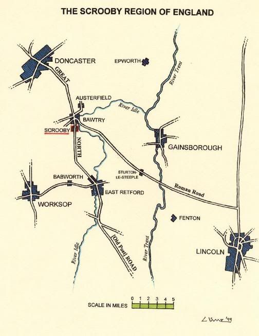
In 1608, group of religious separatists from the English town of Scrooby had moved to Amsterdam and Holland in pursuit of religious freedom since there was only one church approved by the English king, James I who was Protestant.

scrooby.jpg

The location of Scrooby

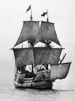
There were two major groups of believers who disagreed with the beliefs and practices of the Church of England. One group wanted to stay in the church, but hoped to change its forms of worship, the "Puritan" because they wanted to "purify" the church. The other group did not believe the state church could be changed and was called "Separatist" because they wanted to separate completely from the Church of England. In 1607 the Scrooby Separatists made their first attempt to leave England for Amsterdam. However, their plan to leave was discovered by the authorities and they were arrested during their attempted departure where many of the men were jailed. After the successful escape to Holland in 1608, the leaders of the Separatists or Pilgrims decided to leave Holland due to overpopulation in relation to the economic situation and the only jobs available were low-paying jobs such as cloth-making and labor intensive jobs. Plus the younger children were losing their English identity, becoming more Dutch and would have been absorbed into the local population. The leaders of the Separatists asked King James for a Royal Charter, which would allow them to establish a colony in the New World, which James refused to give. However, he promised that he would not try to stop them from settling abroad. They secured a land grant from London Virginia Company in 1620 which the conditions that indentured them for seven years before they would be free to take any profits for themselves. The leaders hired Christopher Jones, the captain of the Mayflower to take them to the New World and also bought another smaller ship, the Speedwell to serve as a fishing boat. The leaders wanted for the entire Leiden congregation would move to America, but they decided to send only sixty or seventy to establish a settlement and for the rest to come later. Since there had not been enough volunteers to fill the two ships, a group of non-Separatist people was enlisted to fill out the required number of passengers for the voyage. At Southampton, the Speedwell was deemed unseaworthy so the Mayflower had to make the voyage by itself and finally left port on September 16, 1620. Of the 102 passengers aboard, only 41 were from the Leiden congregation.

article-warwick-mayflower.jpg

The Mayflower

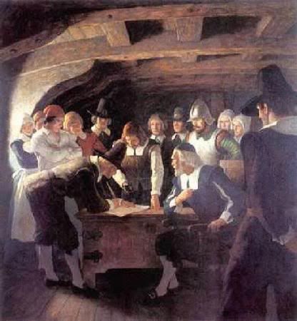
Finally after 2 months of storm heavy waters at sea, the Mayflower spotted the coast. They arrived in November initially at Provincetown Bay and later settled at what became Plymouth. The Pilgrims had intended to settle near the mouth of the Hudson River, but had been blown off course in stormy weather. Even before the settlers left the ship, there was a near mutiny as indentured servants wanted their freedom now and do what they want since now an ocean divided them between Britain, which would have presented the Separatists leaders with a problem since they would need everyone to prepare for the winter. To solve the problem, the Pilgrims wrote the Mayflower Compact, an agreement signed by all the men on board-including the indentured servants-promising to abide by laws that would be drawn up and agreed upon by all male members of the community. It also stated that they would choose their own leaders and make their own laws and there would be equal justice for all. The Mayflower Compact was signed on board the Mayflower at Cape Cod in southeastern Massachusetts on November 21.

MayflowerCompact.jpg
 
Wow, great new update.

I am not very good at this part of the American history, is there any alternative history at the moment?

BTW: Every day American tourists visit the place from which the Speedwell set sail for America, it is in Delfshaven just two kilometers from me ;)
 
Again very good. You have to wonder what the Mayflower's passengers would think of Massachusettes today.