Noord-Kustland, a model of Dutch coastal provinces. (PS4)

  • We have updated our Community Code of Conduct. Please read through the new rules for the forum that are an integral part of Paradox Interactive’s User Agreement.

Nivec

Sergeant
21 Badges
Oct 19, 2017
88
5
  • Cities: Skylines - Green Cities
  • Crusader Kings III
  • Stellaris: Federations
  • Prison Architect: Psych Ward
  • Stellaris: Ancient Relics
  • Cities: Skylines - Campus
  • Prison Architect
  • Stellaris: Megacorp
  • Cities: Skylines Industries
  • Cities: Skylines - Parklife
  • Stellaris: Apocalypse
  • Cities: Skylines
  • Stellaris: Synthetic Dawn
  • Cities: Skylines - Mass Transit
  • Stellaris - Path to Destruction bundle
  • Cities: Skylines - Natural Disasters
  • Stellaris: Leviathans Story Pack
  • Stellaris
  • Cities: Skylines - Snowfall
  • Cities: Skylines - After Dark
  • Cities: Skylines Deluxe Edition
This is my first city journal. I will give an introduction about my play style and why I make Noord-Kustland (North Coastland).

I have been playing Cities Skylines since 2017. First on PC, and when my laptop had a burnout I settled for PS4. I play through phone- that is Remote Play in combination with an old Sony Experia. At first I had to get used to the touch screen controls, but I got used to it. Nothing beats playing games while lying in bed next to my wife, lol.

The idea for this playthrough came after I tried building an elementary-education-only town. I had to resort to Low Density level 1 zoned areas, with minimal services and lots of garbage disposals. At around 8000 pop I stopped and looked at what I had made: it looked very much like a cluster of German or Dutch villages, and I wanted to extend that idea.

I own the DLCs and content creator packs, but I'll mostly make use of Industries and European Suburbia content for this province. I have enabled the "unlock all milestones" cheat, which is a first time for me. This is because a lot of small Dutch villages have a church or chapel in the centre, so I need the cemetery. I also need district styles, greenhouses, and transportation options for industry: If I decide to extend the town, it can extend around the station/harbour that would have been there since the establishment of the village. I have disabled disasters because I just want to see how things will work, not how things will be destroyed (because I do some detailing).

I am playing on Green Peaks map, because I wanted a map with low elevation and lots of water. Rivers are already present, and making new canals remains an option.

EIMB1psWoAANyEw.jpg

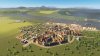
This is the first village, Koggerbrug. Its industry is based on Animal Products, and some generic industry near the riverside. Along the stream is some light commercial zoning. The waterway is not connected to a shipping route so I think this village won't grow much more. It counts little over 1000 pop.

EIMBpEsXYAAow4R.jpg

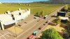
Seen from the provincial highway, the exit to Koggerbrug. The waste disposal facility also takes care of garbage from a village further up north.

EIMBrOrXsAU13lR.jpg

A closer look at the rural low density residences of Koggerbrug. Enough space for extended backyards. Even gravel roads which are actually uncommon in public space in the Netherlands.

EIMBqagXsAAKJKz.jpg

The central access road with a small amount of shops, a police station and a church. No schools, nor medical facilities!

Next is St. Anna, based around Crops and Flour industry:

EIMB1G_XkAA6-8S.jpg

St. Anna is not yet connected to the provincial highway. For now it is only accessible through the same road that gives access to Koggerbrug. It counts nearly 1000 pop. Near the bottom you can see the Crops and Flour industry, with its own few generic industrial buildings to alleviate heavy traffic from Koggerbrug to St. Anna.

EIMBw-zWwAAdp29.jpg
St. Anna's agricultural industry. The turbines were necessary because the Kogger coal power plant didn't produce enough to supply both villages. Now it looks even more Dutch!

EIMBwTbWwAATNta.jpg

I just realised a bicycle lane is missing, parallel to the connector road! Problem is, the road in bottom right direction still runs to nowhere. Coming soon.

EIMBxpBXkAAjllr.jpg

St. Anna wouldn't be "Saint" without the chapel. The post office to the left side supplies mail service to Koggerbrug as well. Still no clinic, and still no school!

The next settlement will feature a cargo station and a bakery, based on some bigger industrial towns that can be seen in real life somewhere between Amsterdam and Haarlem.

I started with 580.000 c to spend, and now I have 80.000 c left. I need to plan the next village more carefully. Luckily I am making some profit by now, although not much.

EIMB2DXW4AAoCTB.jpg

Until next time!
 
subbed
 
Part 2: The big small city of Langerit

This time I will tell you about the industrial town of Langerit. You'll know I like to roleplay a bit, so if you don't mind some creative writing I think you'll enjoy reading it as much as I do writing it. I keep a rough outline on my mind when I develop the coastal province of Noord-Kustland, but most ideas come and go before I get a chance to play again!

Let me draw how the current map is built:
[Coastline] ----- Langerit -- Harderzand -- St. Anna -- Koggerbrug ----- [Highway exit]

As it was, all these settlements (from coast to provincial highway) were connected with a single road. The agricultural goods of Koggerbrug, St. Anna, and Harderzand were mostly transported to the port facility and bakery of Langerit. There, the goods were processed and delivered to the shops, but mostly they were exported through the renovated Langerit Cargo Hub, or sent back to the highway exit- congesting the connector road that runs through all settlements.
EIQ2WQaXUAAWckf.jpg

The port of Langerit is connected by railway and road. In the distance you can see the historical high density residences.


EIQ2QnuXkAU40d-.jpg

A better look at the true size of Langerit. It looked small, but because of its comparison to the smaller settlements, inhabitants of the province called it 'the city' because they didn't know much else than it. It was also the only settlement that featured an elementary and high school, a medical facility, and a police- and firestation.
On the left side of the railway you can see Harderzand. Its development spanned only the single road running through it, but on paper it owned the land on the left side of the railway.


EIRDLL7W4AAVTdo.jpg

Langerit then got green light from the village of Harderzand to build houses across the railway, only if Langerit rolled out a bicycle lane through the village. Both parties agreed, and soon after St. Anna and Koggerbrug extended the bicycle lane through their villages as well.


EIR7ezpWsAAs1Q8.jpg

The new bicycle lane, with St. Anna in the distance.


EIR7eMhWoAA0AvT.jpg
The bicycle lane around Harderzand. Many people made use of the bicycle lane, but heavy traffic into Langerit was still backing up all the way past Harderzand! More work needed to be done for infrastructure.


EIQ2lRqX0AE82WI.jpg

The worst intersection where all industrial and commercial traffic of Langerit went in and out on the right side. This photo was taken during quiet hours. Plans to make a roundabout and wider roads were initially hindered by the Provincial Government, as it needed demolition of some of the buildings in the city center. Its historical center is on the World Heritage list, so the local government only allowed redevelopment if further development would happen around the existing buildings.


EIR7RyfXsAMF9FL.jpg
Infrastructure was improved, but traffic flow was still straining the economy and environment.
While the roads were redeveloped, the public park also got an overhaul (see below, before and after)


EIR7SmbXsAIU09b.jpg

EIR7TgAWkAAYLEX.jpg

The park was also included in the monumental status of the city center, raising land value of the surrounding buildings!


EIQ2kfEXkAAqi7B.jpg

Now we are looking at St. Anna, because we see that the provincial highway got to a dead end just across the small canal. The small industrial zone of St. Anna was vital to the village, as Langerit was too far away by current infrastructure. Many years back the mayor of St. Anna turned down Langerit's proposal to have the highway cut through its industrial area.
St. Anna was basically putting the province in a stranglehold as inevitable growth would strain the infrastructure more and more if a highway wouldn't come. Going around it wasn't an option too, as it would cut through the small natural reserve of Scharwater. Langerit in its turn didn't agree with an on- and off ramp into St. Anna, as it would affect traffic flow to and from Langerit all over again.
The only proposal that worked, took almost a decade to take shape: St. Anna allowed the highway to cut through if an overpass was made. And to compensate for not having a highway ramp, Langerit would vouch for St. Anna's proposal (at the Provincial Board) to have its own mall!


EIlrhCMW4AAW1js.jpg

The result: An extended highway over St. Anna...


EIlrnyNXUAALpLe.jpg

The highway would divide traffic types: Straight on towards the industrial zone, to the right towards the residential area and proposed modernised districts.
Traffic flow was finally relieved and ready for the coming decades.


EIlrrf0W4AYhMpX.jpg

...and St. Anna got its very own shopping mall. It was taller than the church, making the mall a peculiar symbol of change to come. The building clearly outsized the demand of St. Anna, putting the village in the center of attention for Harderzand and Koggerbrug. St. Anna's few shop owners weren't all too happy as they saw it as unfair competition, a loss of business, and some felt forced to move into the mall to keep their customers in exchange for high rent. Another challenge was to give easy access to tourists and residents from other villages.
 

Attachments

  • EIR7c91XUAEyaYF.jpg
    EIR7c91XUAEyaYF.jpg
    333,6 KB · Views: 6
Last edited:
Part 3: Ambitious Anna

Langerit improving its infrastructure was quite successful, as some high capacity traffic was finally made possible along the border of its historic centre. It also got a much needed highway connection that went through St. Anna.
In its turn, St. Anna got its own mall. To the villagers it felt weird to have their own mall, and they had to get used to the influx of tourists and commuters from surrounding settlements. The mayor had some plans for the village, and not everyone appreciated the changes that were welcomed.

vriendschapsbeeld Langerit.jpg

Across the mall, a plaza and statue were unveiled by the mayor and the owner of the establishment. It symbolised friendship and appreciation towards Langerit and its support for approval of the mall. The block of houses that bordered the square, was redeveloped for commercial use. St. Anna offered the former residents of the area newly built houses in the back of the village. With a fair relocation allowance, most citizens were willing to move. Some moved out to smaller surrounding villages, as they thought that the old characteristics of St. Anna were now fleeting.
Despite the extension of the residential area and new commercial opportunities, the mayor was criticised for the development. His efforts were called his 'vanity project', because the former shopowners were neglected and the mall simply felt 'too big' for the village.
The mayor understood what was asked. Meetings were held with the villagers to make fair plans for the future.


station en winkelcentrum Langerit.jpg

Langerit was well aware what the opening of St. Anna's mall meant in terms of land value, attractiveness and tourism. Langerit didn't stay behind and opened its own mall -a more luxurious mall than Anna's- and the very first passenger train station! Tourists started to come to the province, but mainly they stayed in Langerit of course.


eerste hoogbouw Langerit.jpg

These changes brought high demand to residential and commercial development. Residences were upscaled to modernised highrise. The first ones were seen around the monumental park. The skyline was slowly changing from smokestacks to apartments and stores.


verdeling oud en nieuw Langerit.jpg

A clear division between old and new is seen along this road. Note that all visible buildings are residential. When this picture was taken, Langerit counted almost 9000 inhabitants.


ontwikkeling Langerit.jpg

An overview of Langerit's development some years after St. Anna opened its mall.
After these plans were realised, a tax raise of 2% was implemented on Langerit's commercial and residential zones.


bibliotheek.jpg

Back in St. Anna, demands of the villagers were met with the opening of its library. A literacy programme kicked off that even encouraged a few people to study at a university in the neighbouring province. When Noord-Kustland counted 10.000 pops, 50 of them were university graduates!


bijbusLangeritstation.jpg

St. Anna invested in getting more tourists to the mall. The village opened its own depot with seven buses, and the first bus line was a fact. Not surprisingly, the line ran from Langerit trainstation straight to St. Anna Mall! The expected increase in tourism was seen immediately. A side effect was that people from St. Anna and even Koggerbrug used this bus line for a trip to Langerit. Langerit was happy to see how all communities were profiting from the development, and subsidised the purchase of three more buses.


zandweg.jpg

The gravel road that connected the backsides of Langerit and St. Anna was upgraded to a two-way highway for regular use of the bus line. This way, the old connector road wouldn't be congested more.


eerste clubs en hotels.jpg

Here you can see St. Anna's first development of (night)clubs and hotels. Some of the old shop owners saw a better opportunity offering diversity to tourists, rather than keeping their old quiet corner shops. Residents across the street were complaining about noise pollution, so a 'lights out!' policy was implemented, ordering the tourist zone to close at night. The land across the street was wanted by companies that wanted to open their business there, but residents were not willing to move out. The increasing conflict of land use was disrupting unity within St. Anna. Also, the mayor's term was ending next year. No one could predict how St. Anna -or how fast St. Anna- would develop with a new mayor!

Below an overview of St. Anna, before and after.
luchtopname st anna 1.jpg
luchtopname st anna 2.jpg
 

Attachments

  • eerste buslijn.jpg
    eerste buslijn.jpg
    392,7 KB · Views: 7