Borders look crooked, ahistorical and need fixing

  • We have updated our Community Code of Conduct. Please read through the new rules for the forum that are an integral part of Paradox Interactive’s User Agreement.
The borders are 'crooked, ahistorical and need fixing' in comparison to what? An unsourced YouTube video?
Below some historical mapping of the subdivisions of the region which is well known (Baltic medieval subdivisons, particularly in Livonia, are very well documented in this period). The youtube video was more so a joke about how even an amateur can get it right if one just traces directly from source materials. I find the insinuation that I'm basing this all off a video funny though.

Now show me just one singular map that corresponds with what is in the current build of Project Caesar? :p

Im guessing whoever made these maps all just collectively made the same mistake? ;)
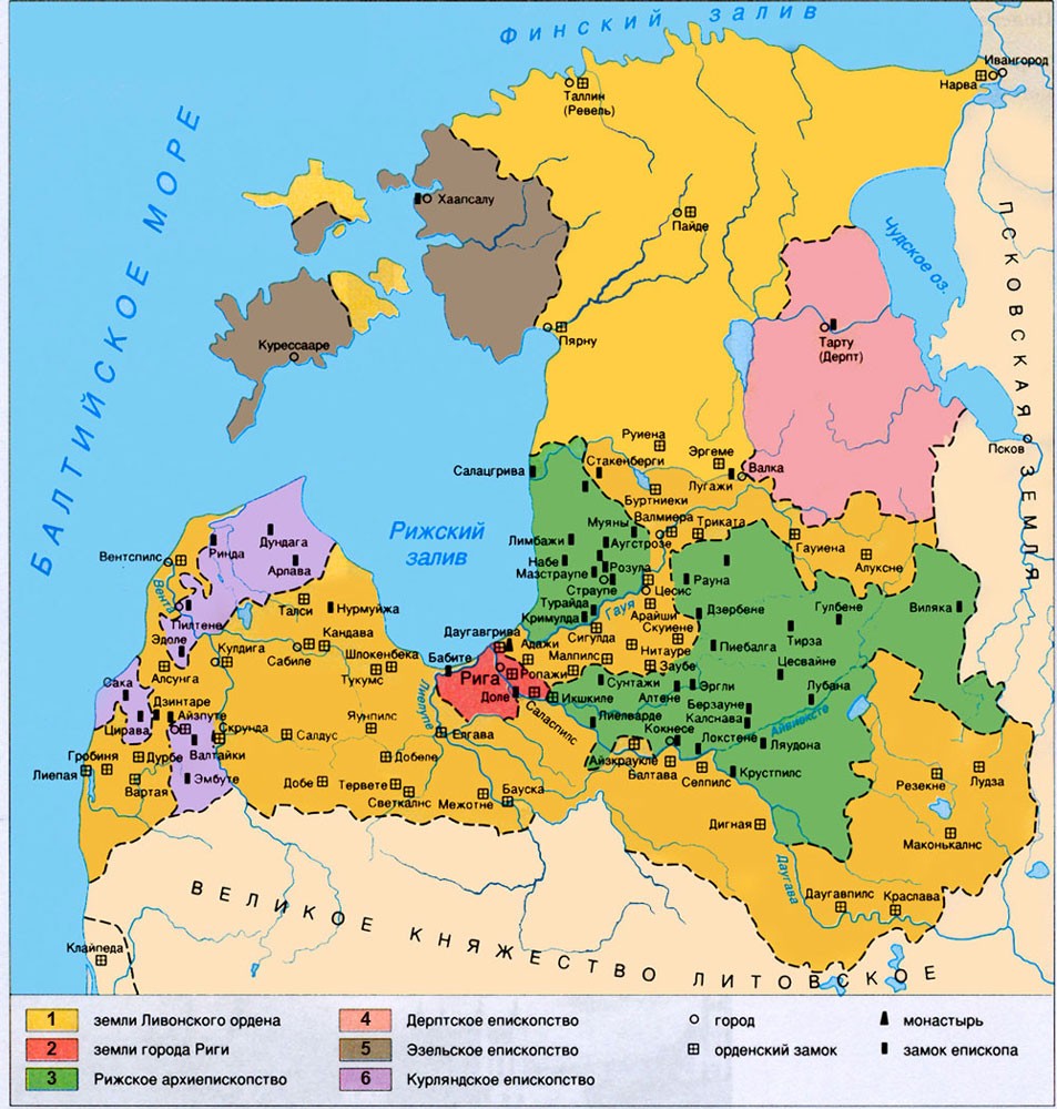
map-livonian_order_XII-XVIcentury.jpg


300px-Livonia_in_1534_(English).png


flat,750x,075,f-pad,750x1000,f8f8f8.u1.jpg

85ea6c118d6fdded6507f682b1233c48.jpg

teutonic_order_by_19north95-d8gg35d.png


PNG.png
 
  • 4
Reactions:
How long is the coastline of Great Britain?
 
  • 6Haha
  • 1
Reactions:
If the borders are just straight up wrong, they should be fixed, of course. But if the borders of the individual locations do not match the 1337 borders and this is done for gameplay/later historical borders then it could make sense to not perfectly match the historical 1337 borders, and the OP doesn't seem to acknowledge this?
 
  • 7
  • 2Like
Reactions:
If the borders are just straight up wrong, they should be fixed, of course. But if the borders of the individual locations do not match the 1337 borders and this is done for gameplay/later historical borders then it could make sense to not perfectly match the historical 1337 borders, and the OP doesn't seem to acknowledge this?
The borders are straight up wrong for centuries because the subdivisions of Livonia and how it was divided for centuries looks nothing like the current build. And like I keep repeating these borders are well documented and were clearly defined for centuries.
 
  • 3
  • 1
Reactions:
Below some historical mapping of the subdivisions of the region which is well known (Baltic medieval subdivisons, particularly in Livonia, are very well documented in this period). The youtube video was more so a joke about how even an amateur can get it right if one just traces directly from source materials. I find the insinuation that I'm basing this all off a video funny though.

Now show me just one singular map that corresponds with what is in the current build of Project Caesar? :p

Im guessing whoever made these maps all just collectively made the same mistake? ;)

Hey mate. After looking at your maps, it would seem you are right. Perhaps consider rewriting your post more along the lines "the baltic region borders could use a rework, here are my sources". Why use a terrible looking youtube video or the high school book map when you have these? If your point was to say that it was super easy to do better, that's not really constructive. Perhaps rephrase the title as well as some people have been confused as it implies you are talking about aesthetics not historical accuracy.
 
  • 10Like
  • 2
  • 1
Reactions:
Hey mate. I don't dissagree with your post's message. Perhaps consider rewriting your post more along the lines "the baltic region borders could use a rework, here are my sources". Why use a terrible looking youtube video or the high school book map when you have these? Perhaps rephrase the title as well.
The youtube video was more so a joke about how even an amateur can get it right if one just traces directly from source materials. The school book was also me being hyperbolic.

Bit weird how everyone seems to be questioning the need for historical accuracy on the graphical element we will be spending 99% of the time looking at just because I show that even amateur youtuber mappers can get it right. Truly amazed at how I'm getting disagrees due to people who aren't reading the OP fully and instead just assuming things.
 
Last edited:
  • 10
Reactions:
The youtube video was more so a joke about how even an amateur can get it right if one just traces directly from source materials. The school book was also me being hyperbolic.

Bit weird how everyone seems to be questioning the need for historical accuracy on the graphical element we will be spending 99% of the time looking at just because I show that even amateur youtuber mappers can get it right. Truly amazed at how I'm getting disagrees due to people who aren't reading the OP fully and instead just assuming things.
I think most people would agree with you if the post had another format. I am going to make a new post about this as I care about border accuracy as well. Do you mind if I use some of your maps?

Edit : I used them. If this bothers you, let me know I'll take them down and redraw them myself.
 
Last edited:
  • 1
  • 1Haha
Reactions:
After a post on the forum, I did some research on the Estonia / Livionia area and believe the current borders aren't very accurate for 1330's.
It does not seem to be a case where the data is absent, and there is general concensus from what I found on how borders were in the region at the time.
I will first link the current pdx map, and then my sources that suggest alternate borders. Some of these maps are courtesy of @Moppy771.
Current:

1714695422136.png


Now for the proposed new map with sources. I understand some of the disconnected countries might be an issue for gameplay, or there might be no issue and they would be fun to play so I'll link the map as is.
The dent in Demark, doubling of the size of the Archbishoprip of Riga and division of Courland are the largest changes.
Proposed:

1714695584998.png


Sources.

1714697446023.png
End of XIV century
1714696635074.png
Euratlas (btw the website is really cool if you want to check it out)

1714696828404.png
16th century --Thomas Hockmann 2004

1714697252800.png
1260
Finding exact academic sources isn't easy for me for these images.
If anyone finds conflicting maps with semi-reliable sources, drop them below I'll amend my post. Otherwise, these threads are for suggestions and here is one: the borders of the Baltic states region could use a tweaking.
 
  • 9Like
  • 4
  • 2Haha
  • 2
  • 1Love
Reactions:
The youtube video was more so a joke about how even an amateur can get it right if one just traces directly from source materials. The school book was also me being hyperbolic.

Bit weird how everyone seems to be questioning the need for historical accuracy on the graphical element we will be spending 99% of the time looking at just because I show that even amateur youtuber mappers can get it right. Truly amazed at how I'm getting disagrees due to people who aren't reading the OP fully and instead just assuming things.
I hope the devs ignore you purely based on your attitude ngl.
 
  • 5
  • 3
  • 1Haha
Reactions:
Later we will have weekly posts asking for feedback for specific regions besides the regular talks. So get all your sources and materials ready for it, we will talk a lot about maps
 
  • 39Like
  • 18Love
  • 1
Reactions:
Petty nationalists being mad about minutae inconsistencies that have almost zero influence on the GRAND strategy never fail to amuse.
To quote Johan yesterday "a Castillian, an Aragonese, a Basque and a Catalan walked into a bar..."

Also, I'm quite sure "sources and material" is the important bit in sanke's post (apart from "later")
 
Later we will have weekly posts asking for feedback for specific regions besides the regular talks. So get all your sources and materials ready for it, we will talk a lot about maps
Would it help if my sources came with some vitriol and anger on the side or would it be best if that got left behind? I could stretch to calling you all silly sausages if it is of any benefit? :)
 
  • 7Haha
  • 2
Reactions:
After a post on the forum, I did some research on the Estonia / Livionia area and believe the current borders aren't very accurate for 1330's.
It does not seem to be a case where the data is absent, and there is general concensus from what I found on how borders were in the region at the time.
I will first link the current pdx map, and then my sources that suggest alternate borders. Some of these maps are courtesy of @Moppy771.
Current:

View attachment 1127117

Now for the proposed new map with sources. I understand some of the disconnected countries might be an issue for gameplay, or there might be no issue and they would be fun to play so I'll link the map as is.
The dent in Demark, doubling of the size of the Archbishoprip of Riga and division of Courland are the largest changes.
Proposed:

View attachment 1127119

Sources.

View attachment 1127128 End of XIV century
View attachment 1127122 Euratlas (btw the website is really cool if you want to check it out)

View attachment 1127123 16th century --Thomas Hockmann 2004

View attachment 1127125 1260
Finding exact academic sources isn't easy for me for these images.
If anyone finds conflicting maps with semi-reliable sources, drop them below I'll amend my post. Otherwise, these threads are for suggestions and here is one: the borders of the Baltic states region could use a tweaking.

I have provided a download link to a SHP of Livonia in 1340 (accurate to the best of my knowledge) in the Tinto Talks that originally brought up Livonian borders. I do hope they downloaded it (I know some folks did, but not sure who), but in general you are right. However, some approximations may be necessary (for example, leaving Denmark the "dent" which is Järvamaa/Gerwien – though this seems to have been already changed based on the latest TT).
 
Last edited:
  • 1
Reactions:
What it "should" look like if borders were made historically accurate:


And here's one of the many amateur historical mapping attempts one can find on YouTube who even manage to get it right:


Now I know some might say "they'll fix it later, much more important things are being addressed right now" which may be true, but how does one not do it right the first time? I mean surely these borders are being traced from -somewhere- in the first place? I used the Baltic as an example for this post but I can imagine there's similar inaccuracies elsewhere if I did a deep dive. Again, this isn't that much of a nit-pick since this region has very well defined historical boundaries in comparison to areas where control and boundaries were more "vague" at the time.

It's important to know why the borders are like that more than just knowing that they are wrong.

For example, in this case, the dev's approach to Danish territory is better than what you are proposing, because of the following reasons:

a) It should be the Teutonic Order's *if* it was a separate province, but honestly it's such a minor land there's no need to turn it into a province.
b) The Bishop of Tallinn had spiritual control over the area, and officially the Teutonic Order was forbidden to fortify this position.
c) The nobility of this area had quite a bit more freedom compared to the nobility of the rest of the Teutonic Order.
d) If we now consider this an unfortifiable area that the Danes "own", it's more or less okay to have it as an appendage of Harjumaa/Harrien (where Reval is on your image).
e) In later history, this region was more or less always controlled by the same people who controlled Reval/Tallinn.

A much more important change in this part would be to divide the one Danish province into two (Harrien/Harjumaa and Wierland/Virumaa/Vironia). I proposed this and a number of other changes to bring Livonia into a better balance in the topic where this part of the map was originally included.
 
  • 2Like
  • 1
Reactions:
I've just seen the updated version in this week's Tinto Talks. In my book, it's already a lot better than what it was, including the distribution of Danish lands. There are of course other comments that could be made, now, and actually it seems the third Danish province more or less is what Gerwien was, so this should go to the Teutonic Order, but overall, it looks positive (including Tartu split into two).
 
I have actually provided the devs with a SHP of the Livonian borders in 1340 (accurate to the best of my knowledge).
So if I draw a shapefile, it's a source ?

Let me draw a shapefiles for, let's say, the Pacific Northwest. or the Congo then :)


Maybe better not, there'd be a lot of contradicting sources...