
WATK African Beta
- Thread starter cool-toxic
- Start date

-
We have updated our Community Code of Conduct. Please read through the new rules for the forum that are an integral part of Paradox Interactive’s User Agreement.
You are using an out of date browser. It may not display this or other websites correctly.
You should upgrade or use an alternative browser.
You should upgrade or use an alternative browser.
Religions i wish to see in.
Western Christianity
Catholic
Counter Reform Catholic
Avignon Catholic
http://en.wikipedia.org/wiki/File:Great_schism_1378_1417-C2.jpg
Protestantism:
Lutheranism (Europe except for England)
Anglicanism (England)
Puritanism (for the Puritans, English Civil War)
Reformed:
Calvinism (some german provinces, Netherlands, Swiss)
Huguenots (french protestants)
Presbyterianism (Scottland, USA)
Hussite (Bohemia, there are plausible reasons to put them in the reformed group)
Eastern Christianity - Orthodoxy
Eastern Orthodoxy (Europe)
Oriental Orthodoxy (Africa)
Assyrian Church of the East (Christians from the Near East to China)
Islam
Sunni
Shiite
Ibadism (Oman, Mzab, Islam in East Africa)
Alevism (Kurdish provinces)
Druze (Maybe in the Levant; they were a pain in the ass for the ottomans)
Updated the Africa and America maps
Your wish has been fulfilled.
") Now I skipped the Assyrian Church, but I added Zwinglian instead.
Now I skipped the Assyrian Church, but I added Zwinglian instead. Yes. But the existing version 1.88 is a nice one, too.
sure,i agree
but the Outer Mongolia and Manchuria is so "fat",i feel not very comfortable about the scale.
the acreage of solonu +manchu or the oirat only is as big as Ming one the map.
sure,i agree
but the Outer Mongolia and Manchuria is so "fat",i feel not very comfortable about the scale.
the acreage of solonu +manchu or the oirat only is as big as Ming one the map.
Can you please draw on the map how the borders should be instead?
We have already doubled the amount of nations in the game. Well defined most of them only, but some have been added to scenarios as of now.
Can you please draw on the map how the borders should be instead?
I can not draw,but there is a pic I feel best on scale
I have no comments about the political borders
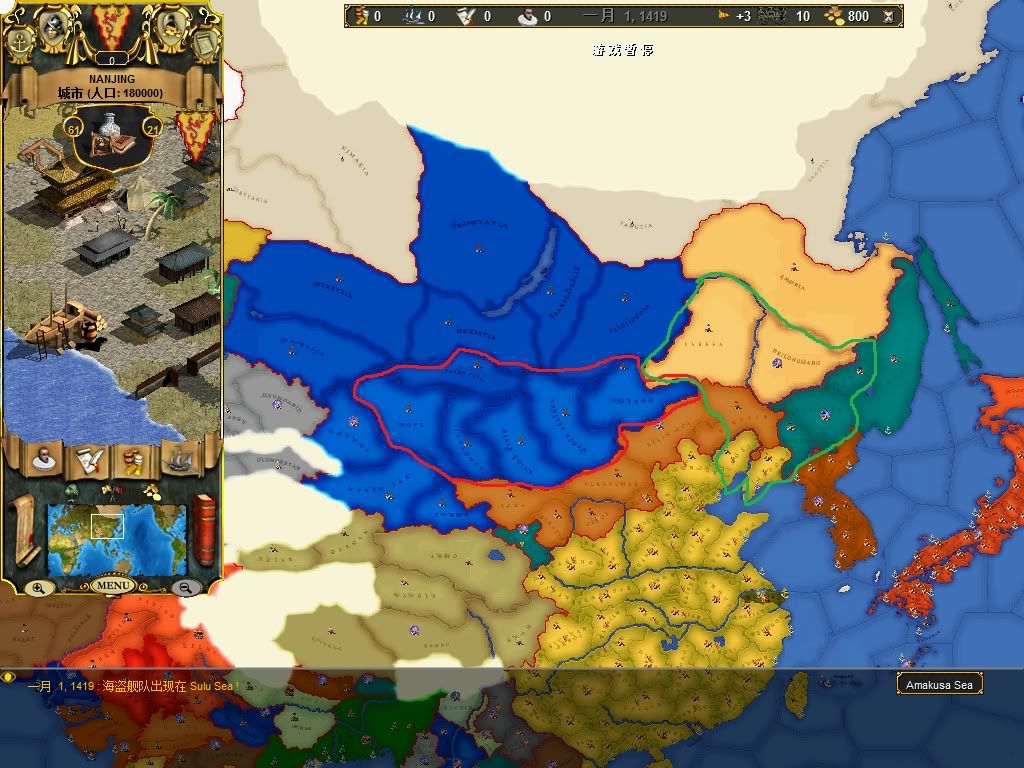
Outer Mongolia in red and Manchuria in green(amuria maybe a liittle fat than it should be)
Last edited:
from mymap-agceep 14a
the scale is prefect though the number of provices is few.
the scale is prefect though the number of provices is few.
Last edited:
It just looks different because of the other dimensions and amount of provinces. If you think yourself a line from the westmost border of Solonu in MyMap down to Beijing, you are with your line one province left of Beijing. If you do the same with the WATKABAOI map, you will also be one province left of Bejing.
But i see know that Ha Mi is maybe at the wrong place.
But i see know that Ha Mi is maybe at the wrong place.
It just looks different because of the other dimensions and amount of provinces. If you think yourself a line from the westmost border of Solonu in MyMap down to Beijing, you are with your line one province left of Beijing. If you do the same with the WATKABAOI map, you will also be one province left of Bejing.
But i see know that Ha Mi is maybe at the wrong place.
you are right.it is a bug of 14a
I have no idea about the meridional line, but the pic I post just make me feel better,maybe it's a opinion most of the people live in east Asia have.Many friends told me that same sense.
anyway.we are familear with the map of east Asia so we have the sense
thank moders very much
Last edited:
That I can understand, but it would be too much to change such an large area I am afraid, If you could draw lines on our map and show it might be easier for me to evaluate.
I am back ,I made a mistake.I find the map of Mongolia and Manchuria is fine after I intalled the version for FtG.
the problem is Sinkiang,I feel that Taklimakan Desert is not in a right location as a forever-unknow area:more west than it should be,and a little south?(not very sure)
and by the way,Macao should be a byland.HK is a island.but in map.HK is a byland and Macao is a island, maybe it is for the balance of the game.
about the map of Africa,I think Watk-lite is better than WATKBAOI though WATKBAOI have more provinces.
the reason is the border of provinces in Africa of WatkBAOI obviously draw base on the colonial map draw by imperialist.it recalled me a sad memory.....and I donot think no forever-unkonw area in Africa is a good idea especially for Sahara.
on the other hand,the map of Africa of WATKBAOI is very suitable for a modern day mod............
Last edited:
Hi
There is brocken link to download the CK -> WATKABAOI converter
Can it be reposted, please?
Thanks in advance!
There is brocken link to download the CK -> WATKABAOI converter
Can it be reposted, please?
Thanks in advance!
Download link's broken, could someone please upload it again?
Thanks
Yeah, I was kind of waiting for it too :C
I am curious Cool Toxic... How much time did you take converting the provinces.csv file? I guess that is the file that takes more time to convert... right?