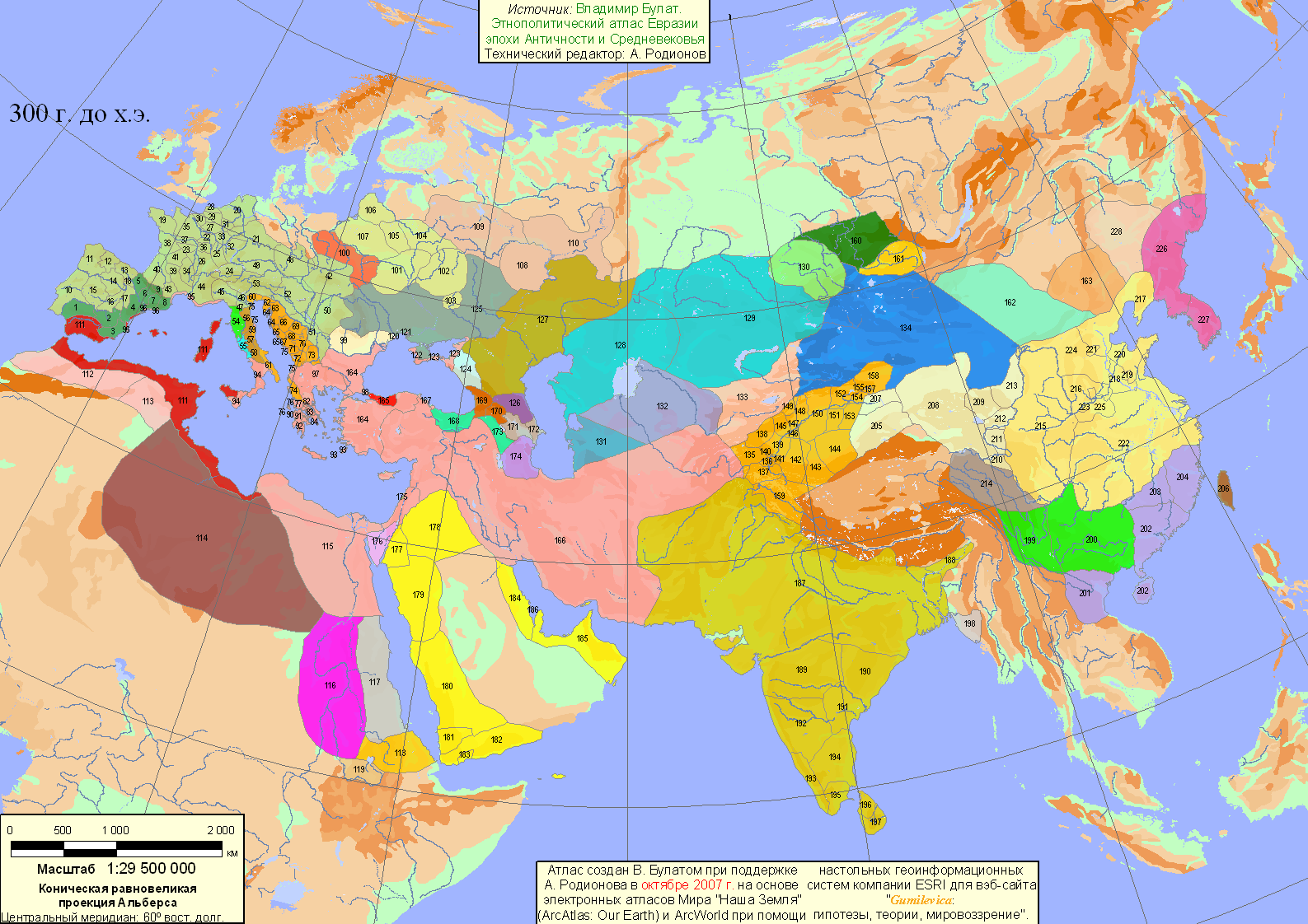
One of the DD's before the release stated that the Digital Atlas of the Roman Empire was used to name the territories, which is great as this is the most complete source of ancient roman place names easily accessible. However, it doesn't cover the areas beyond the Roman frontier and it seems that territory names e.g. in Germania were made in some random fashion, thou I noticed some references to tribal names and ancient toponyms.
GERMANIA
I want to point out this german research published in a monograph and reported by Spiegel:
"A group of classical philologists, mathematical historians and surveying experts at Berlin Technical University's Department for Geodesy and Geoinformation Science has produced an astonishing map of central Europe as it was 2,000 years ago /.../ This unusual map draws on information from the mathematician and astronomer Ptolemy /.../ One of these drawings depicts "Germania Magna," /.../ Ptolemy demonstrated extensive knowledge of this remote area, indicating the locations of mountains, rivers and islands. An index lists 94 "poleis," or cities, noting their latitude and longitude accurately to within a few minutes. /.../ Yet the data the ancient geographer used is distorted. Errors of scale crept in as he transcribed the Earth's sphere to the flat plane of a map. Ptolemy believed the northern lands to be narrower and more elongated than they are and bent Jutland in Denmark and Schleswig-Holstein in Germany too far to the east. /.../ The Berlin-based team pored over the recalcitrant data for six years, working together to develop a so-called "geodetic deformation analysis" that would help to correct the map's mistakes. /.../ It was primarily surveyors with the Roman army, which appears to have advanced as far as the Vistula River, who collected information on the barbarians' lands. Dieter Lelgemann, a geodesist in Berlin, is firmly convinced that "Ptolemy was drawing on work done by military engineers. /.../ The ancient astronomer indicated cities' exact locations down to minutes of degrees. These coordinates, once decoded, indeed often turn out to line up precisely with sites where archaeologists have previously found Gothic or Teutonic houses and grand burial tombs erected for tribal princes. /.../ "
The article also provides a google maps link with all the "decoded locations" including some description of sites, which can be used to change individual territory names according to this research.

I present just a few examples of some changes that would be made (I compared the I:R map with the google map link):
Contemporary city (country) - current I:R territory name - suggested Magna Germania name:
Brno (CZ) - Phargisatus? - Eburodunum
Kostrzyn (PL) - Iadua - Colancorum
Dresden (DE) - Thuringiana? - Lupfurdum
Actually, by doing the comparison, I noticed that some I:R territories in northern Germany already have some "correct" names, perhaps using a different source related to Ptolemy? Nevertheless, the other located places in interior and East Germany, Austria, Poland, Czechia and Slovakia should be included as well.
SCYTHIA
While I am at it, I also suggest looking at other sources. I want to point out the famous place of Gelonus from Herodotus's Tales on Scythia: "The Budini for their part, being a large and numerous nation, are all mightily blue-eyed and ruddy. And a city among them has been built, a wooden city, and the name of the city is Gelonus. Of its wall then in size each side is of thirty stades and high and all wooden. And their homes are wooden and their shrines. For indeed there is in the very place Greek gods’ shrines adorned in the Greek way with statues, altars and wooden shrines and for triennial Dionysus festivals in honour of Dionysus."
"Excavations at Bilske Horodyshche (uk:Більське городище) near the village of Bilsk near Poltava in Ukraine (Coordinates 50°5′34″N 34°38′46″E ) have led to suggestions by archaeologist Boris Shramko and others identifying it as the Scythian capital Gelonus.[2] It is strategically situated on the exact boundary between the steppe and forest-steppe. /.../ According to Herodotus each side of Gelonus is 30 stades long, the area in today's units would be about 30 square kilometres. The archeological site around Belsk, including necropolis, comprises about 80 km², and the fortifications enclose some 40 km². The north-south axis, along the Vorskla River is 17 km long. The remains of walls up to 12 metres are visible today and stretch over the horizon. The total length of the ramparts is 33 km. Inside the fortification, lay three "keeps", 150,000 m², 650,000 m², and 720,000 m² in area, surrounded by eroded earth walls still up to 16 metres high. Several kurgans reminded the inhabitants of the ancient Scythian burial tradition."
Contemporary city (country) - current I:R territory name - suggested Herodotus name:
Bilsk (UA) - Volg - Gelonus
Bilsk is actually just beyond the edge of the map, Volg is the closest match.
GERMANIA
I want to point out this german research published in a monograph and reported by Spiegel:
"A group of classical philologists, mathematical historians and surveying experts at Berlin Technical University's Department for Geodesy and Geoinformation Science has produced an astonishing map of central Europe as it was 2,000 years ago /.../ This unusual map draws on information from the mathematician and astronomer Ptolemy /.../ One of these drawings depicts "Germania Magna," /.../ Ptolemy demonstrated extensive knowledge of this remote area, indicating the locations of mountains, rivers and islands. An index lists 94 "poleis," or cities, noting their latitude and longitude accurately to within a few minutes. /.../ Yet the data the ancient geographer used is distorted. Errors of scale crept in as he transcribed the Earth's sphere to the flat plane of a map. Ptolemy believed the northern lands to be narrower and more elongated than they are and bent Jutland in Denmark and Schleswig-Holstein in Germany too far to the east. /.../ The Berlin-based team pored over the recalcitrant data for six years, working together to develop a so-called "geodetic deformation analysis" that would help to correct the map's mistakes. /.../ It was primarily surveyors with the Roman army, which appears to have advanced as far as the Vistula River, who collected information on the barbarians' lands. Dieter Lelgemann, a geodesist in Berlin, is firmly convinced that "Ptolemy was drawing on work done by military engineers. /.../ The ancient astronomer indicated cities' exact locations down to minutes of degrees. These coordinates, once decoded, indeed often turn out to line up precisely with sites where archaeologists have previously found Gothic or Teutonic houses and grand burial tombs erected for tribal princes. /.../ "
The article also provides a google maps link with all the "decoded locations" including some description of sites, which can be used to change individual territory names according to this research.
I present just a few examples of some changes that would be made (I compared the I:R map with the google map link):
Contemporary city (country) - current I:R territory name - suggested Magna Germania name:
Brno (CZ) - Phargisatus? - Eburodunum
Kostrzyn (PL) - Iadua - Colancorum
Dresden (DE) - Thuringiana? - Lupfurdum
Actually, by doing the comparison, I noticed that some I:R territories in northern Germany already have some "correct" names, perhaps using a different source related to Ptolemy? Nevertheless, the other located places in interior and East Germany, Austria, Poland, Czechia and Slovakia should be included as well.
SCYTHIA
While I am at it, I also suggest looking at other sources. I want to point out the famous place of Gelonus from Herodotus's Tales on Scythia: "The Budini for their part, being a large and numerous nation, are all mightily blue-eyed and ruddy. And a city among them has been built, a wooden city, and the name of the city is Gelonus. Of its wall then in size each side is of thirty stades and high and all wooden. And their homes are wooden and their shrines. For indeed there is in the very place Greek gods’ shrines adorned in the Greek way with statues, altars and wooden shrines and for triennial Dionysus festivals in honour of Dionysus."
"Excavations at Bilske Horodyshche (uk:Більське городище) near the village of Bilsk near Poltava in Ukraine (Coordinates 50°5′34″N 34°38′46″E ) have led to suggestions by archaeologist Boris Shramko and others identifying it as the Scythian capital Gelonus.[2] It is strategically situated on the exact boundary between the steppe and forest-steppe. /.../ According to Herodotus each side of Gelonus is 30 stades long, the area in today's units would be about 30 square kilometres. The archeological site around Belsk, including necropolis, comprises about 80 km², and the fortifications enclose some 40 km². The north-south axis, along the Vorskla River is 17 km long. The remains of walls up to 12 metres are visible today and stretch over the horizon. The total length of the ramparts is 33 km. Inside the fortification, lay three "keeps", 150,000 m², 650,000 m², and 720,000 m² in area, surrounded by eroded earth walls still up to 16 metres high. Several kurgans reminded the inhabitants of the ancient Scythian burial tradition."
Contemporary city (country) - current I:R territory name - suggested Herodotus name:
Bilsk (UA) - Volg - Gelonus
Bilsk is actually just beyond the edge of the map, Volg is the closest match.
Last edited:
Upvote
0
")