• We have updated our Community Code of Conduct. Please read through the new rules for the forum that are an integral part of Paradox Interactive’s User Agreement.
Thanks, cool-toxic :)

This weekend I'm heavily working on the map. Today I'll show you Arabia, Palestina, Phoenicia, Syria and Persia - here are all in one:


And here is low resolution show of actual Ptolemy World Map as a whole:


I'm heading now to the north - over Armenia and Caucasus to Sarmatia.
Stay tuned...
:)
 
Last edited:
Ok, I'll keep it up ^__^

Here is finished Scandinavia (added provinces of Finland and northern Norway and Sweden)


and here is brand new part - Central Asia
(rivers are still missing there)
 
When can download this map?
I have absolutely no idea.
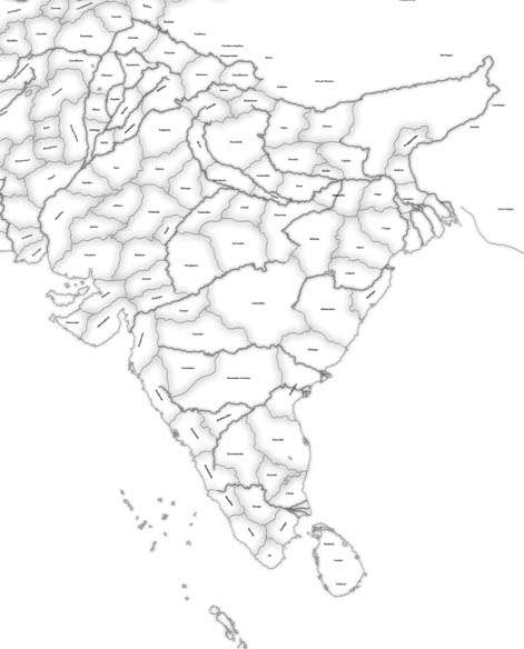
I have a lot of work due the end of semester. I think that drawing land provinces on the shadings layer may be finished in February (not too much remaining now - just India, Indo-China and China).
But there is still a lot of work waiting after the shading layer (optimizing of number of provinces, drawing of ID layer and work on data in CSV)

EDIT:
Notice that the map is in development for about 8 months and the borders are still not finished
 
Great progress.

If you need, I think I could scan some maps of ancient Armenia for you. So if you are interested PM me, ok?
 
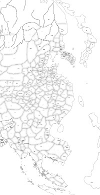
Indo-China, China, Korea, Japan, Mongolia
(rough borders placement - no details)


By this is the land design almost done. Now I'll be recounting the actual provinces and making optimizations if needed.
Roma Universalis requires Ptolemy Map in its next release so at least a little piece of this map will be out during the end of February.

Basileios I >> Sorry for late answer. However, I have no ingame screens for now.
 
First province counting ended with a possitive result - 1650 land provinces. There is enough space for rivers, lakes and sea zones.

Sectors counting however encountered a little problem. 3 sectors have a large density of provinces. One sector already failed in counting. That problematic sector contains Gallia + Brtannia + western Germania + northern Iberia.
100 provinces from these areas must be removed.

The other two high-density sectors weren't checked yet, but it is possible that number of provinces in north-western Africa and in Greece and Anatolia will be reduced as well.
 
What do you think about merging all rivers into one province?

Positives - It'll give space to safe 15-30 more provinces in each sector.
Negatives - Names of rivers will be lost, and even if only little area in Europe would be discovered, you'd see all rivers and lakes also in China, etc.
 
What do you think about merging all rivers into one province?

Positives - It'll give space to safe 15-30 more provinces in each sector.
Negatives - Names of rivers will be lost, and even if only little area in Europe would be discovered, you'd see all rivers and lakes also in China, etc.

so make a compromise :)
merge all regional rivers into 1 province.. f.i. West European rivers, East European rivers, Chinese rivers etc.
 
Greece is in serious trouble. There is allowed just 256 provinces in each sector.


Yes, the sector where Greece is has right now over 500 "land" provinces :wacko:
More than half of them must go out :(
 
Negatives - Names of rivers will be lost, and even if only little area in Europe would be discovered, you'd see all rivers and lakes also in China, etc.

No this is not true. Only lakes work this way. Rivers, on the other hand only show if you know a province bordering the river. So they will only show in the area you know.

I have done this in the maps I've made.
 
Rivers, on the other hand only show if you know a province bordering the river. So they will only show in the area you know.
Wait, but what if all the rivers are under one ID? When I discover the province bordering with the river, the whole river shows up, doesn't it? And since all the rivers would be under one same ID, they would appear all together as the game would recognize them as one river through the ID.
Or the game will recognize that some parts of the discovered river are separated from the discovered part of the "same" river, so it wouldn't display those separated parts? :confused:

Well I don't know how the engine works.. But from what I can see it works as you latter from. It will seperate the rivers even though they are all under one ID. ;) So this way one can free up a lot of IDs. :) Oh btw, maybe try to move your map if possible to make the high density areas in the center of 4 regions. :) Look what we did for AU, we hit the regionlimits but we just moved the map around and that saved us from deleting tons of provinces.
 
It will seperate the rivers even though they are all under one ID. ;)
Ah, that's great. Didn't know that :)

Oh btw, maybe try to move your map if possible to make the high density areas in the center of 4 regions. :)
Yeah, I did that already to get rid of a lot of Germanic provinces from the Gallic sector. And the situation above is the result of it, otherwise instead of one 500-province sector I'd have two 450-province sectors plus one with 350.
The problem is, that whole Europe is "High density" :D

(This happens when you begin creating map without knowing about the sector's limit existence :D)