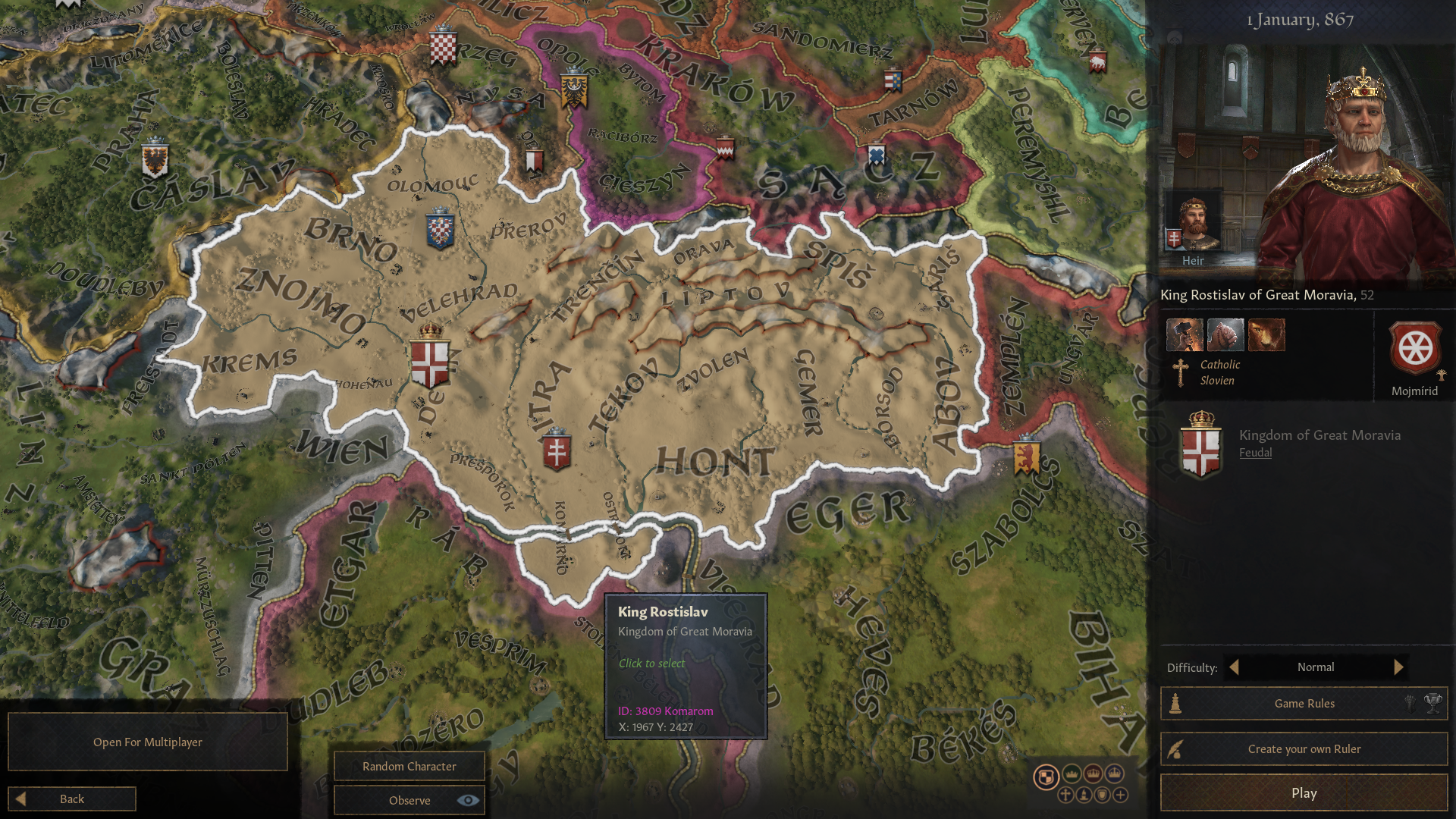
[Map] Ibn Battuta's Legacy 2 - An alternative vanilla map WIP

  • We have updated our Community Code of Conduct. Please read through the new rules for the forum that are an integral part of Paradox Interactive’s User Agreement.
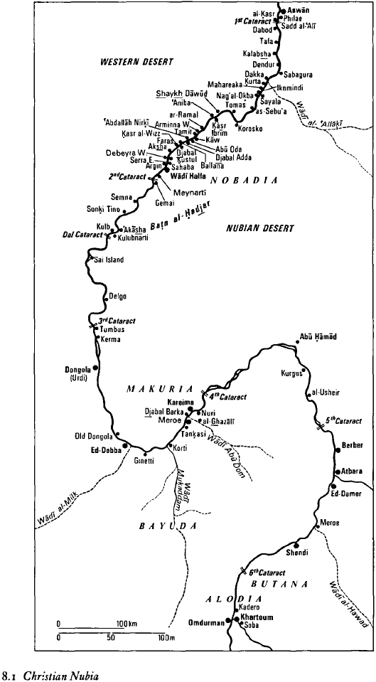
I remember after watching a show on Nubia on the Science Channel looking for Meroë then being confused as to where it was marked to be on the Paradox maps.
To be honest, you can get confused from far more scientific work than Science Channel or Paradox maps:
to pick just one of works and scientific papers, here's UNESCO History of Africa:
Africa_08-1_Christian_Nubia.png
 
Last edited:
  • 1Love
  • 1
  • 1
Reactions:
Re your question, do you happen to have any screens what it would look like if you split Wadi el-Milk into a duchy? Makes it easier to compare which looks prettier! :p
Sorry, I forgot about this one,

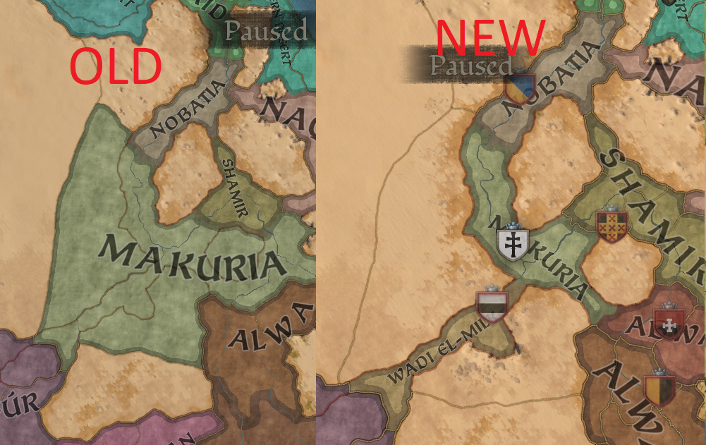
here's the comparison - old and new duchies of Nubia:
Nubia-duchies.png
 
  • 8Like
  • 2
  • 1Love
Reactions:
North Eastern Nigeria - Kwararafa and Kano sketch
Status update...

I'm intensively working on the mod's update and I finally got to phase where I can share something.

But before updating you about this, let me share one very important information
This is the last planned update dedicated to Africa for a while. After this I plan to - finally - move back to Europe and do some planned updates also there.

The update of East Hausaland and what used to be Kwararafa duchy is quite massive as you can see.

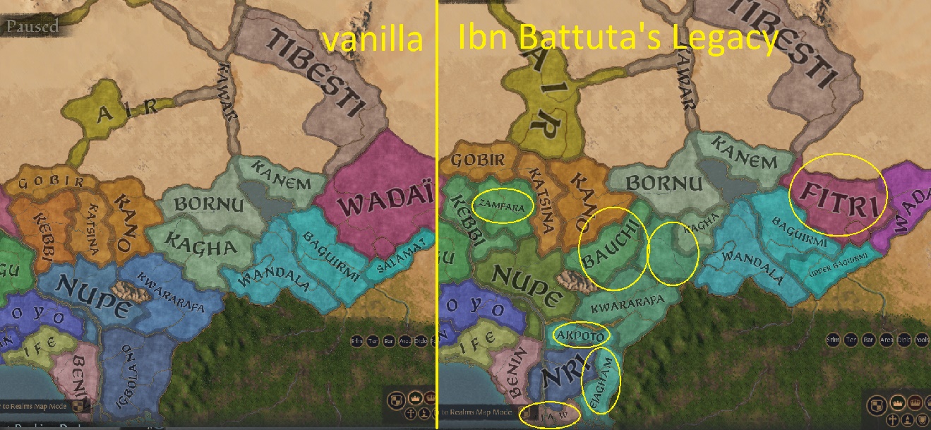
The former duchy of Kwararafa from the Igbo-Benue kingdom has been upgraded into a full kingsom with 3 duchies: Kwararafa, Upper Kwararafa and Bauchi.
Kwararafa-Hausa.jpg


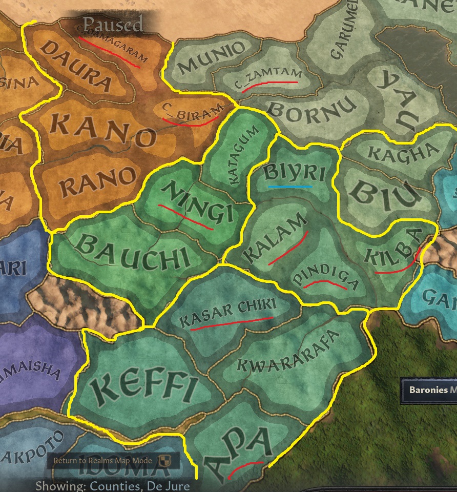
You can see that Kwararafa region has 6 new counties and one (Katagum) has been moved from Bornu to this Kingdom.
The former province of Fika was renamed after one of the Kwararafan capitals and princedoms of Biyri.
Each of medieval principalities of the Jukun people of Kwararafa was made a separate county.

You can also see that Bornu kingdom was compensated and for the lost county of Katagum, it got a new county of Zamtam.

On barony/province level, the changes are even heavier:
Kwararafa-Hausa-baronies.jpg

The slightly anachronistic names such as Gombe or Wukari were replaced by slightly more accurate baronies Panda and Jibe,
the general barony name of Kwararafa is now called Beipi, after one of Kwararafan capitals, and so is the case of Gongola barony - instead of the river it is now called after one of Jukun principalities: Kalam.

This update will also include new cultures for this region I was updating, more info about them will come later, as well as other news about timing of the long-due mod's update.

Since the game's update/patch/DLC isn't yet announced, I guess I should be able to release the update before the game gets an update.
 
  • 4Like
  • 3
  • 1Love
  • 1
Reactions:
Status update:

I'm getting very close to finnishing the update and here is yet another teaser of what you can expect. Guess what I have added?

update-Africa.png
 
  • 2Like
  • 2
  • 2
Reactions:
  • 2Like
Reactions:
  • 1Like
Reactions:
and here is another teaser... with a question...
WestAfrica-kingdoms1.png

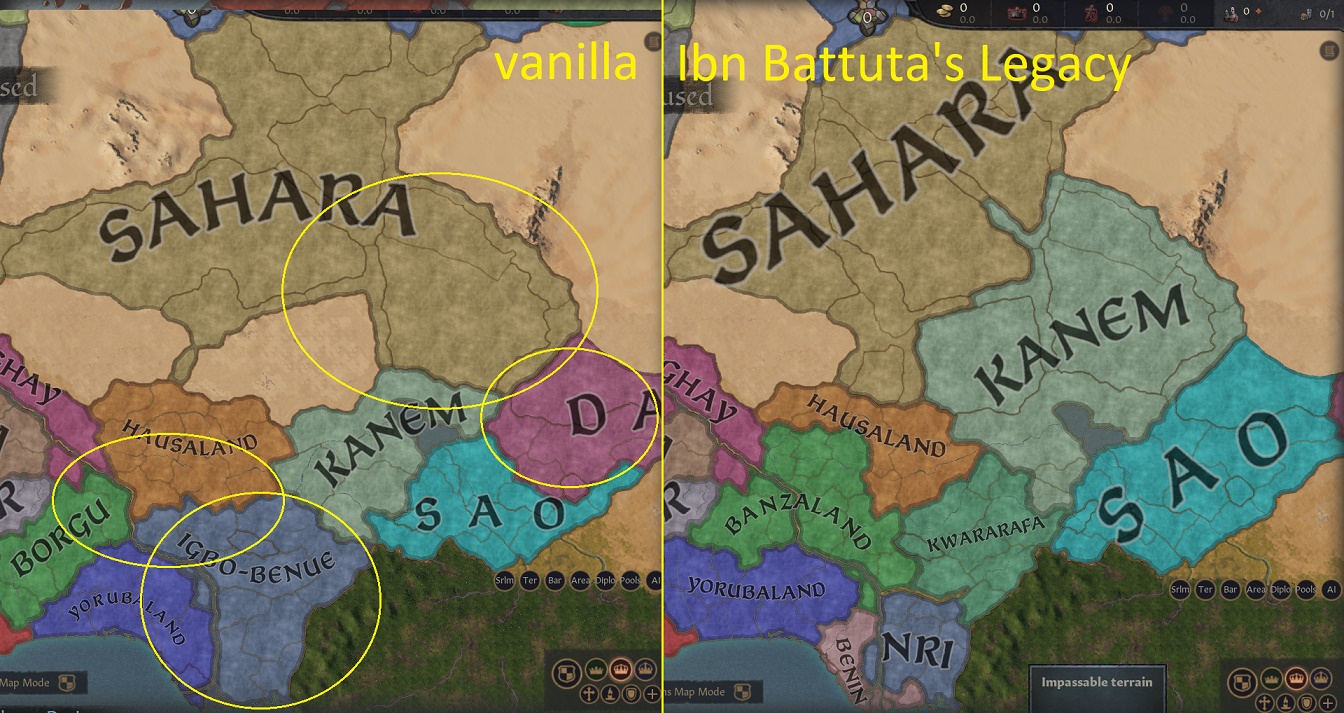
You can see new Ibn Battuta's kingdoms setup for West Africa and the Sahara.
the new kingdoms are Benin and Kwararafa,
Banzaland has replaced Borgu and Yorubaland expanded slightly westwards to take the duchy of Savalu, which was formerly given to Borgu, but would be totally out for Banzaland.

Banzaland is based on the Hausa concept of Hausa vs. Banza states, where the Hausa states were founded by trueborn descendants of Bayajida while Banza were said to be founded by his bastards. That's for the myth - in reality the Banza states were in reality states influenced or in contact with the Hausa people and they are said to be 7, although various versions of the legend/concept/myth list various states.
The stable ones, occuring in most/all versions are Zamfara, Kebbi, Yauri, Gwari, Nupe and Kwararafa. The ones, which occur only in some versions are: Borgu, Gurma, Yoruba-Ilorin. Since Kwararafa and Yoruba (as well as Gurma) are big enough to be separate kingdoms, I merged the smaller ones to replace Borgu kingdom, and to limit Hausaland to control only the actual Hausa territories.

Another important change, signalled by in the previous teaser, is in the Sahara. I added or altered some of the Saharan corridors.
As already spotted, Ain Azawa now connects Air and Ahaggar. Another one is added to the south of Air - Damergu area now connecting Air directly with Daura and Damagaram (another new county).
With Ahaggar being now a separate county, I also altered the corridors in central Sahara. This all was driven by a plan to change the mutual border of Sahara and Kanem kingdoms. As you can see, I expanded Kanem northwards, so it now includes Tibesti and Kawar, but I wanted to avoid Air being separated from the rest of the kingdom.

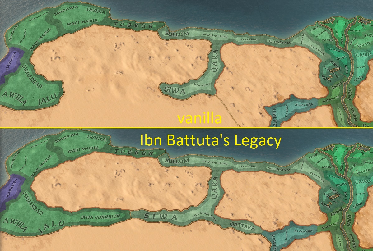
And last thing is in the very corner of this map in Egypt - Siwa and Awjila oases are now directly connected with another new corridor, and one more corridor has been added to connect Siwa with Bahriya oasis of Egypt's al-Wahat.

These are not all the changes and additions for the upcomming update, but certainly the most visible ones.

NOW THE QUESTION:
On the map you can see the red line around Banzaland, Benin, Nri and Yorubaland. I think these 4 kingdoms are enough for a separate empire, but I don't have a name for it. Any ideas? As we discussed it with @Black7Emperor7 the obvious first choice is Nigeria, but it is also the one we would both prefer to avoid if possible. The other possibility would be Lower Niger (empire), but maybe somebody could get a fresh better idea?
You are all welcome to say whatever comes up to your mind, anyone's opition is welcome... but what about @Atimo3 or @Anonymous01 who have previously shown interest in Africa, would you guys have any ideas?
 
  • 2Like
  • 1Love
Reactions:
Of the two you've mentioned, Lower Niger Empire is probably my preference. Personally I'm not too bothered by generic names like that for made up empires, as what you can then do is add cultural names for the title underneath that.

So something like Lower Niger Empire, if held By Edo = Benin Empire
By Igbo = Empire of Nri
Etc.

As coming up with a good name that is adequately inclusive of all of the de jure cultures or kingdoms that can form it is far more difficult than coming up with good cultural names for individual holders of the title imo.
 
  • 2Like
  • 1
Reactions:
just another teaser
 
  • 1Like
  • 1Love
  • 1
  • 1
Reactions:
Ibn Battuta's Legacy 2 new version uploaded
And now the big news.

The mod has been re-uploaded. The changes between the previous and the current version are quite large, so I decided it would be better to consider it a new mod on Steam, rather than an update of the older version.
DOWNLOAD:
The new version of Ibn Battuta's Legacy is available on Steam Workshop as well as on Paradox mods platform

I am still merging the changelogs from various working versions I had into one full changelog, but I already have it graphical:

Let's first look at Bohemia. There are no new baronies, compared to the previous version, but I slightly changed the counties, so that now Velehrad is now a better capital of Great Moravia.
Bohemia-counties.jpg

Bohemia-baronies.jpg


Some changes happened also to terrain of Bohemia - most importantly, the barony of Doudleby now has wetlands terrain instead of hills.
Bohemia-terrain.jpg


Another new thing about Central Europe is that I changed the extent of Slovien culture and expanded it a little eastwards:
Sloviens1066.jpg


Now, before we move to the Sahara and Sub-Saharan Africa, there were some small changes also in Egypt - namely the desert corridors between Cyrenaica's Inland, the Siwa oasis and Egyptian oases of al-Wahat.
Egypt-baronies.jpg


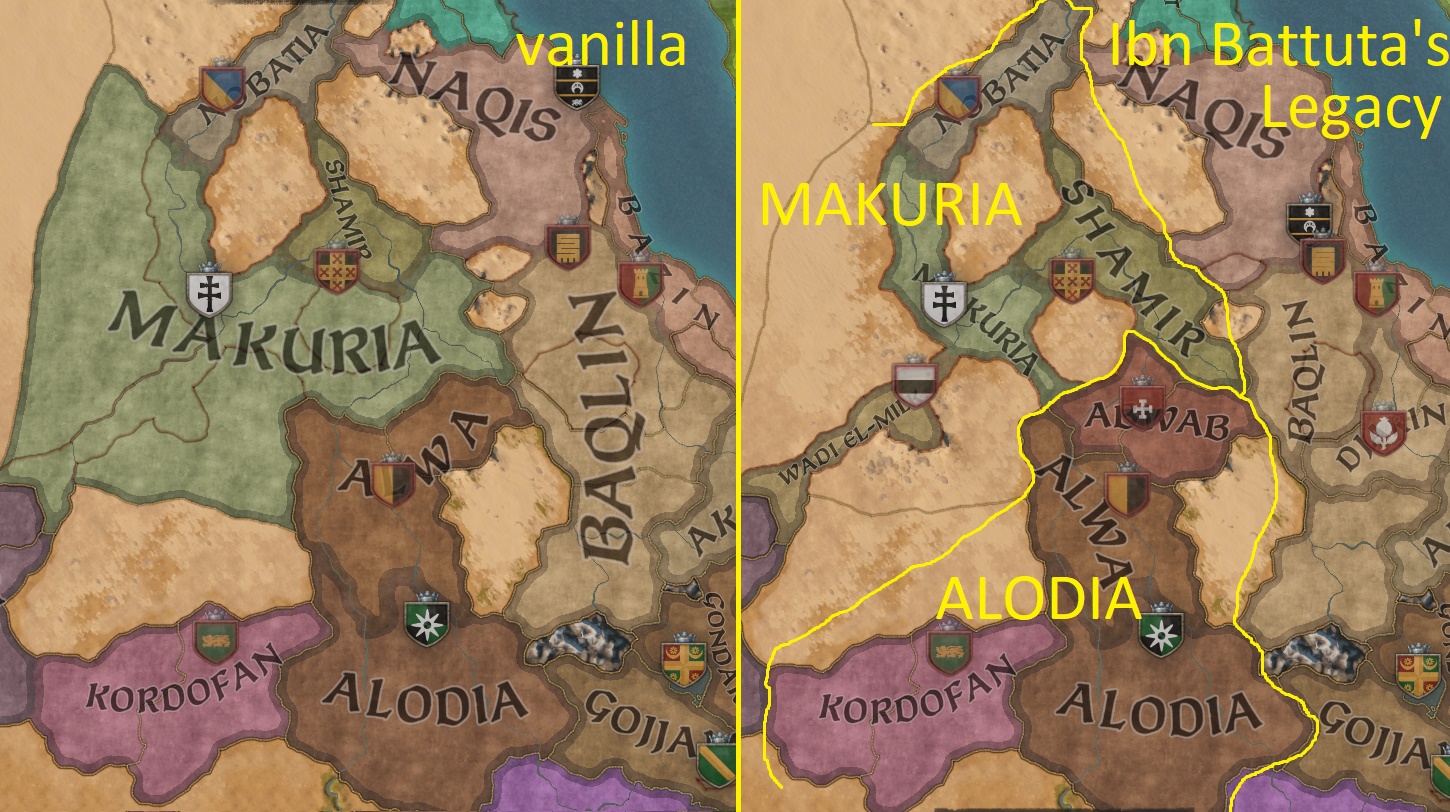
As I already teased, there are also changes in Nubia region. The duchies setup has changed in order to allow the split of Nubia kingdom into Makuria and Alodia kingdoms and with them creation of Nubian empire, which now consists of Makuria, Alodia, Blemmyia and Darfur:
Nubia-duchies.jpg


This was enabled by adding few new counties:
Nubia-counties.jpg


Changes in the Sahara are best displayed on the video I showed in my previous post:
... but they can also nicely be seen on a screenshot of West and Central Africa, which shows the areas of West African Savanna - the new terrain added in my other mod, which is incorporated into Ibn Battuta's Legacy:
Savanna-IBL100.jpg


The most substantial changes of the mod (for now) and this big update are in Sub-Saharan Africa, especially its central part between Lake Chad and Bight of Benin.
As already noted, one change is the addition of (lower) Benue as a major river, but more changes took place there:

Let's start with kingdoms:
Central Sahel-kingdoms.jpg

the kingdoms of Borgu and Igbo-Benue has been replaced by several other entities, better fitting the era of Crusader Kings.
There are 2 entirely new kingdoms: Benin and Kwararafa, and another 2 kingdoms were renamed: Igbo-Benue to Nri and Borgu to Banzaland.

Central Sahel-duchies.jpg

The kingdom of Nri (former Igbo-Benue) is now named after the historical kingdom of Nri, which, however, covered only small section of the region, but was the most influential state of the Igbo people. On its edges it has 2 new duchies - Akpoto, named after the Akpoto people, who are the first known inhabitants of the Niger-Benue confluence, and Ejagham - a duchy, which covers areas of large number of smaller tribes on the edge of our map bordering the Igbos from the east.

In the Niger delta there is the new kingdom of Benin - even smaller, but even more influential kingdom of the Edo people. It's territory is small, though, so to be slightly larger, it also includes the duchy of Ijaw, named after the Ijaw people. But now let's move on to the completely newly overhauled areas to the north of these 2 kingdoms.

Banzaland is based on the Hausa concept of Hausa vs. Banza states. Its de jure duchies are the 3 of the most stable Banza kingdoms: Zamfara, Kebbi and Nupe, plus it also includes Borgu, a kingdom which is usually mentioned among Banza states.
Another of the Banza states was Kwararafa - a kingdom of the Jukun people, which was in the Benue valley and expanded from its 11th century origins in Upper Kwararafa downstream.

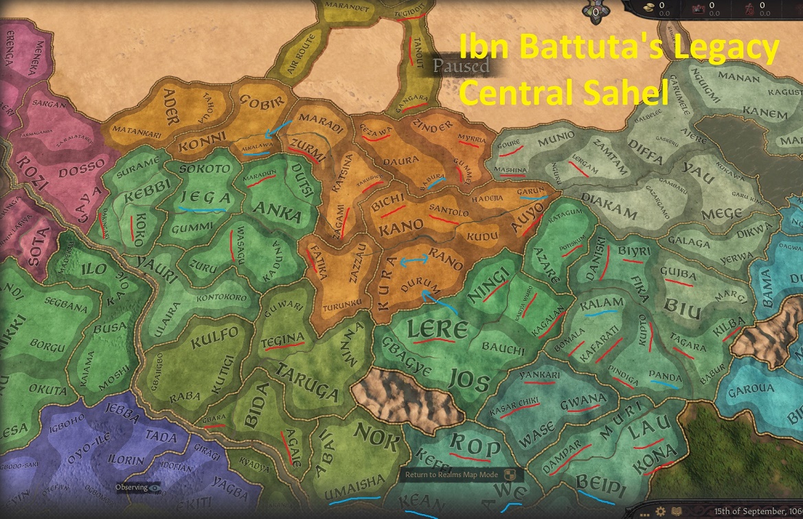
I was able to add all these kingdoms only by adding far more counties and baronies than we have in the vanilla.
Central Sahel-baronies-Igbo.jpg

All the red underlined baronies are new, the blue ones are renamed.

On the counties section you could see that number of counties was also added to Hausaland, which received another small overhaul:
Central Sahel-baronies-hausa.jpg


With this great many new baronies and counties, I was able to finally break the overextended Hausa and Nupe cultures into something slightly better, so there are 2 new cultures in the area, the Akpoto and the Jukun:
Central Sahel-cultures.jpg


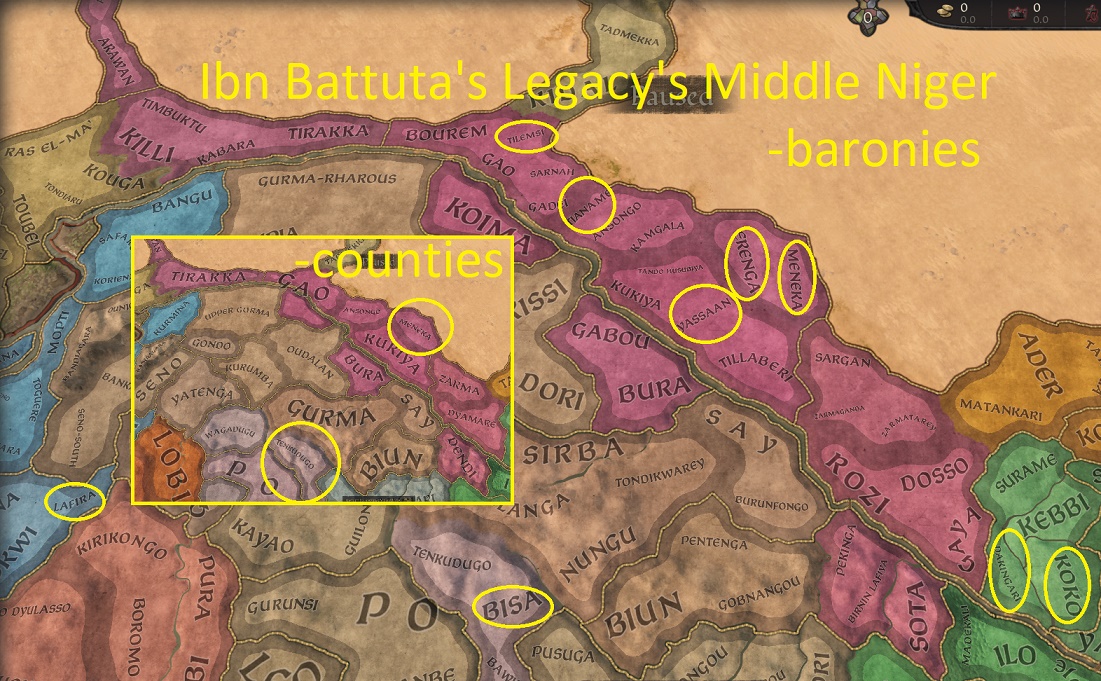
These are the biggest changes. However, there are few small adjustments. Firstly, in the Niger bend area, I not only adjusted the Songhay area, but also added one more barony and county to the Gurma area:
Middle Niger-baronies.jpg


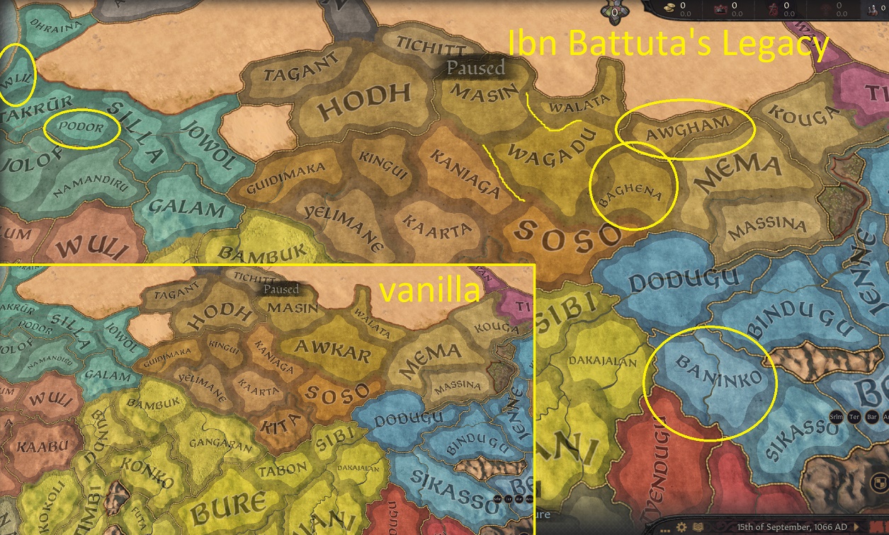
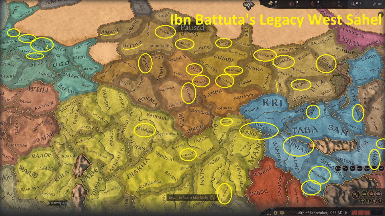
And lastly I made several adjustments to the Ghana/Wagadu area
West Sahel-counties.jpg

West Sahel-baronies.jpg
 
Last edited:
  • 3Like
  • 2Love
  • 1
  • 1
Reactions:
Although Ibn Battuta never visited Europe beyond Granada, his legacy is now moving to Europe...

He has intensively studied notes of older Arab travellers and geographers and the works of Ibn Fadlan taught him about the land of Moravians and their king Svatopluk... well, he probably wasn't, but let's imagine he would and this is how Ibn Battuta's Legacy is going to overhaul the area of Principality of Nitra and other Slavic lands in the north of what became Hungary and, much later, Slovakia.

In general the changes have 2 main motivators:
1) the current vanilla map's county setup is very strongly (and pretty correctly!) based on Hungarian counties (comitates) as they existed in the 13th century, and the settlements do reflect both 13th century and to a degree also pre-Hungarian Slavic settlements. Having studied local historiography with access to more detailed Hungarian and Slovak research, I managed to adapt the map slightly better to the situation of the 11th, and to a lesser degree also 10th century. Some changes were necessary to allow better representation of pre-Hungarian Great Moravian divisions.
2) add, or rather increase the strategic element of the map in this region. The mountainious areas of Carpathians were long only sparsely populated and the propper border between Hungary and Poland was a result of centuries of colonization of the mountains in a line which was least accessible from both sides. I wanted to make this line more visible. Hence I am adding few more impassable mountains, lowering the number of possible passages and hardening them. OTOH, I opened up 2 new mountain passes where they were historically, but not reflected on the map. In particular the pass between Zvolen and Liptov and Ungvár and Sambir - making Ungvar the "entry county of Hungary" from the east, instead of Zemplén, which is now protected by the mountains.

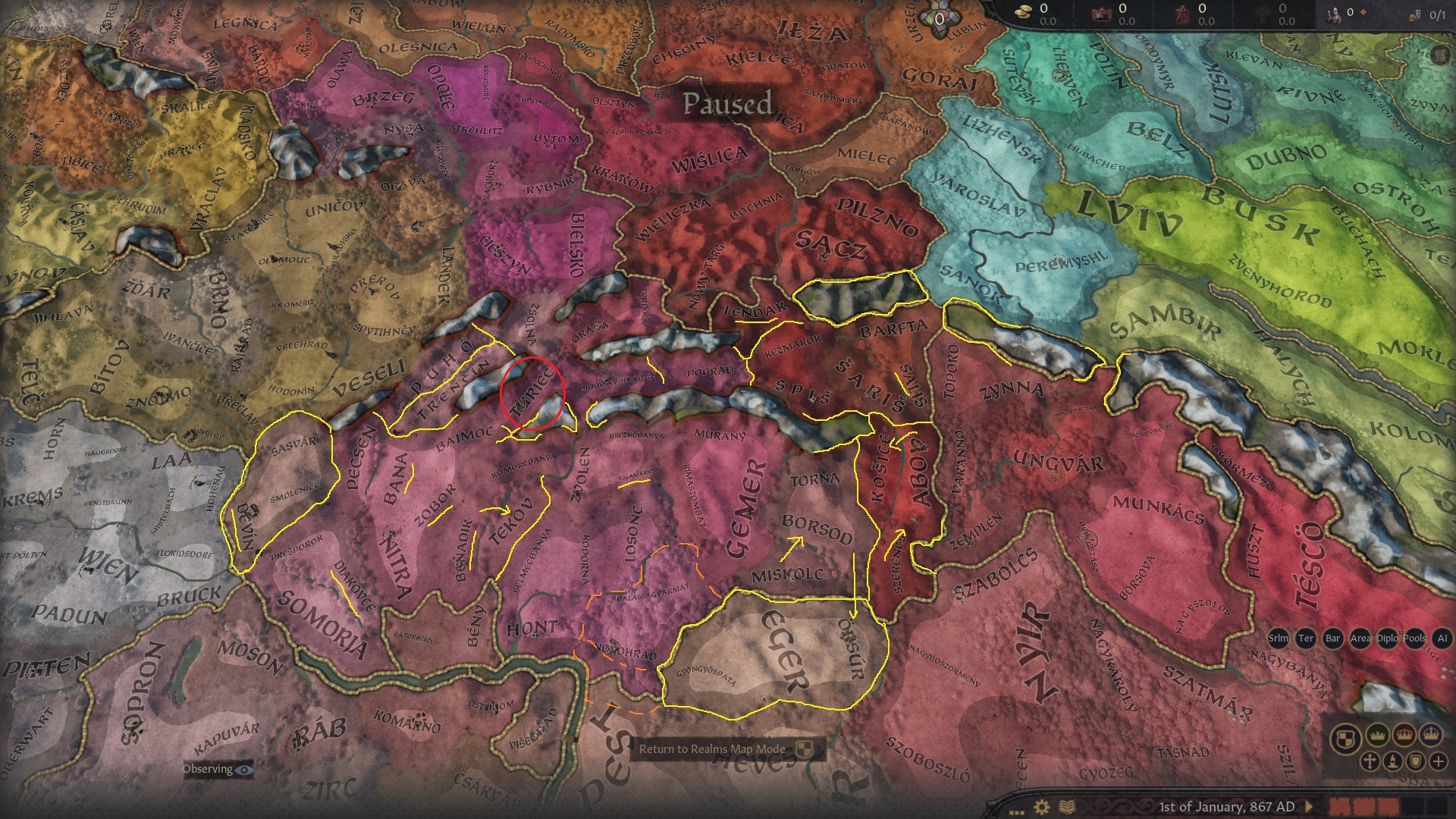
SlovenskoIBL.jpg

On this WIP screenie you can see the changes on the lowest level of baronies.

  • Some baronies were moved - Košice/Kassa, Boršod/Borsod or Tekov/Bars - to their river sides, others, like Trenčín/Trencsén and Púchov/Puhó were set to be only on one side of the river.
  • Some more moving happened in the east in the Abov/Abaúj county - Abov/Abaúj moved northwards, Serenč/Szerencs expanded to the north and was added to Abov county - to reflect the situation of 11th century, rather than 13th century.
  • There are several new baronies
    • Salis, Lendak, Kalamárka and Beňadik are the 3rd settlements of their respective counties
    • Devín/Dévényi and Diakovce/Deáki to allow creation of a new Devín county in the Záhorie region, originally belonging to Moravia
    • Zobor monastery and Bana added to make Nitra/Nyitra county more prominent (it was in the heartland of settled area, yet the Nitra barony was by far the largest in the area)
The plan is to also create a new county of Novohrad/Nógrád separated from Hont and belonging to Visegrád duchy, with a new barony of Vác/Vacov on the Danube

What remains unclear is the question of Turiec. Since the 13th century division it was a separate county, in reality it is relatively isolated valley separated from Trenčín and Nitra by mountains and open to upper Váh river, where it connects to Liptov and Orava (and connects to middle Váh of the Trenčín county). It was separated from Nitra county in the 13th century. In the 13th century it was one of areas belonging to the Váh/Vaag/Waag "province" occupied by Boleslavs of Bohemia and later by Poland, together with Orava, Liptov and upper part of Trenčín area (save Trenčín itself).
The ideal solution would be a separate county, but the region is too small for 2+ baronies, so I am inclined to add it to Liptov (making it its 3rd barony), which makes
most sense geographically, although historically the ties weren't that tight.
Alternatively it can be part of Orava, which makes historical sense (they both separated at the same time), but not so much geographically as it would cut off Trenčín from Liptov.
The last chance is to keep it in Trenčín, which does make sense both historically and geographically (well, no less than the other possible 2 solutions), but looks slightly awkward on the map.

--------------------------------
EDIT:
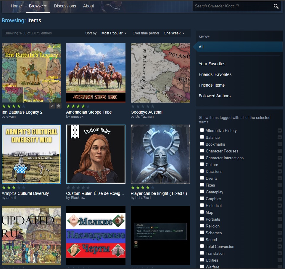
A small note, the mod's re-uploaded version have just surpassed the original mod (from October), after just 5 days on Steam... making it The Most Popular of all CKIII mods weekly. :oops: Thank you, guys! And don't forget to mark how you like it.
IBL-steam.jpg
 
Last edited:
  • 1Love
  • 1
  • 1Like
Reactions:
Ibn Battuta goes to Europe,

As the game will be (probably) updated today, the necessary update of this mod will include few changes in Europe.
I already mentioned in my plans that I have long planned to add Carantanian culture, which is going to happen. I'm still undecided whether to add also a kingdom of Carantania to the early medieval bookmark,
2021_03_16_2.png

Other changes will also be touching primarily the 867 bookmark and also in Central Europe.
The map and de jure changes in Slovakia and northern Hungary were already mentioned above. Beyond these, the update will also include some de-facto changes of 867 Moravia/Nitra:
- Upper Silesia will be released from Moravian state, keeping the setup closer to 860's situation without presuming the upcoming Moravian expansion of Svatopluk.
- Historically the border between Moravia and Austria before 11th century was on the Danube river. Therefore, Moravia in 867 will hold also counties of Krems and Hohenau, which cover most of the Austria north of Danube. For the moment I will keep the Austrian provinces as they are, but I can't rule it out in the future.
- I also tried to stabilize (Great) Moravia and therefore I gave its king Rostislav the Diligent and Brave traits as these define his policies quite well. Similarily I have given some traits to Svatopluk of Nitra.
- and a little teaser - one small change also happened in north-east of Bohemia, especially with regards to Polish-Bohemian wars of the 11th century.

2021_03_15_2.png


Some additonal work is planned for France...
 
  • 1Love
  • 1
  • 1
Reactions: