

Hey there,
It has been a while since the Holy Roman Empire got an extensive rework; Common Sense might be the last time, even. This thread offers a map-suggestion for this region and its surroundings for the upcoming patch/DLC later this year.
The myriad of small states proved to be quite the challenge to represent properly, but I think this a good and realistic suggestion. Lots of design-decisions had to be made and there were still some fundamental errors (dating back from the beginning of the game) on the map that I fixed. This will all be explained in the relevant sections, of course.
Before we begin; this is the Holy Roman Empire, so smaller provinces are kind of warranted to show the complexity of this region. Bishoprics, Free Imperial Cities, Margraviates… I tried to choose the most important ones. As usual; dots indicate the capital city of a province (pinpointed with the help of Google Maps). Some tags have exclaves in other parts of the map, so keep that in mind. The basis of the map was the setup from 1400: https://upload.wikimedia.org/wikipedia/commons/a/a0/HRR_1400.png Obviously complemented with a huge variety of other sources (even German ones) and with the help of some other members from this community. Another useful map was this one: https://upload.wikimedia.org/wikipedia/commons/d/df/Map_of_the_Holy_Roman_Empire_(1618)_-_DE.svg as well as this one: http://www.bielski.de/karten/deu_1477x.jpg
Without further addo;
Northern Germany:

Southern Germany and Bohemia:

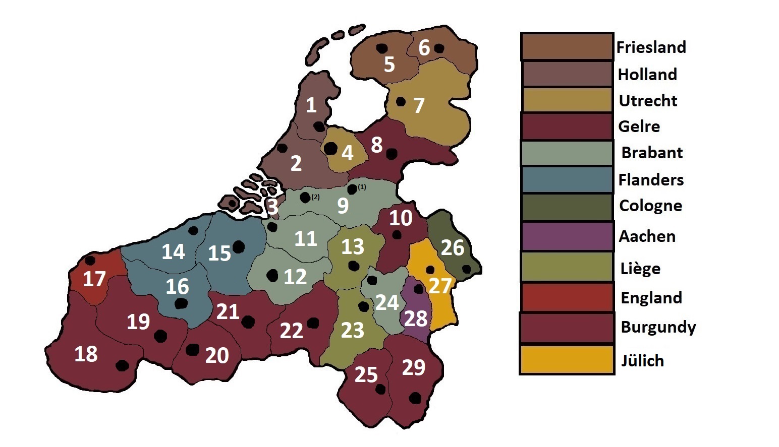
The Low Countries:
I hope the developers take a good look at this for their own work on the region. Even if they won't decide to add al provinces, some general border-reworks needs to be done in any case (as well as city-placing).
It has been a while since the Holy Roman Empire got an extensive rework; Common Sense might be the last time, even. This thread offers a map-suggestion for this region and its surroundings for the upcoming patch/DLC later this year.
The myriad of small states proved to be quite the challenge to represent properly, but I think this a good and realistic suggestion. Lots of design-decisions had to be made and there were still some fundamental errors (dating back from the beginning of the game) on the map that I fixed. This will all be explained in the relevant sections, of course.
Before we begin; this is the Holy Roman Empire, so smaller provinces are kind of warranted to show the complexity of this region. Bishoprics, Free Imperial Cities, Margraviates… I tried to choose the most important ones. As usual; dots indicate the capital city of a province (pinpointed with the help of Google Maps). Some tags have exclaves in other parts of the map, so keep that in mind. The basis of the map was the setup from 1400: https://upload.wikimedia.org/wikipedia/commons/a/a0/HRR_1400.png Obviously complemented with a huge variety of other sources (even German ones) and with the help of some other members from this community. Another useful map was this one: https://upload.wikimedia.org/wikipedia/commons/d/df/Map_of_the_Holy_Roman_Empire_(1618)_-_DE.svg as well as this one: http://www.bielski.de/karten/deu_1477x.jpg
Without further addo;
Northern Germany:
1: Ostfriesland with the capital of Emden. Smoothed the borders a bit, nothing has changed otherwise.
2: Oldenburg with the capital of Oldenburg (1). The current location of the capital is wrong, so I changed that. Also smoothed the borders somewhat. Jever (2) was a city under heavy Oldenburgian influence, even though it was within the confines of the historical Frisian Freedom. Oldenburg also had direct control of it during most of the EU4-timeline, so I kept it within the province.
Source: https://en.wikipedia.org/wiki/Jever
3: Meppen with the capital of Meppen. Its shape has changed a lot, to make way for the counties beneath it which weren’t under the control of the Prince-Bishopric of Münster, yet. The town of Cloppenburg is also within its confines, as Münster took it a while ago.
Source: https://de.wikipedia.org/wiki/Cloppenburg#Mittelalter
4: Lingen with the capital of Lingen (1). A new province under control by the counts of Bentheim-Tecklenburg (but the tag-name is still Tecklenburg, as this was their most important holding). While the castle of Tecklenburg (2) was the seat of the ruling family, Lingen was the economic centre. It has the paper-tradegood (for canvas).
Sources:
- https://en.wikipedia.org/wiki/County_of_Tecklenburg
- https://de.wikipedia.org/wiki/Lingen_(Ems)#Die_Zeit_der_Reformation
5: Osnabrück with the capital of Osnabrück. Not much changed here except for the shape and size of the province, as well as city-placement in general. The Archbishop of Münster was also the bishop of Osnabrück in 1444. Although Osnabrück was sometimes ruled by the current Archbishop of Münster, it had its own bishop several times between 1444 and 1803. It should be a releasable tag.
6: Münster with the capital of Münster. Drastically changed its shape to match the maps more.
7: Cleve with the capital of Kleves. Changed the position of the capital and took off a small bit from the Netherlands.
8: Berg with the capital of Düsseldorf. Controlled by the rulers of Jüllich-Berg (the new Jüllich-tag).
Source: https://en.wikipedia.org/wiki/Duchy_of_Berg
9: Mark with the capital of Dortmund. Although Hamm was the capital, Dortmund was far more economically important in this region (even if it was a Free Imperial City). Its tradegood should be grain. Soest (2) was conquered a bit earlier during the Soest-feud, that’s why the province has this shape.
Sources:
- https://en.wikipedia.org/wiki/County_of_Mark
- https://translate.google.com/translate?hl=de&sl=de&tl=en&u=https://de.wikipedia.org/wiki/Soester_Fehde
10: Bremen with the capital of Bremen. Its borders are smoothened a bit, to make room for new provinces beneath it (which is not ahistorical, as Bremen only controlled a small amount of territory). Its city has been moved a tiny bit, too.
11: Stade with the capital of Stade (1). Well, this one is interesting: It was historically under the control of the Archbishopric of Bremen (not to be confused with the Free Imperial City from before). Its currently part of Verden-tag, but I gave it its own Archbishopric of Bremen-tag (now called after the province, Stade). I made sure that parts of the Elbe weren’t as broad as before, as the position of Stade on the EU4-map was under water because of this; in short, Stade was moved to the correct position on the map. Even though Bremervörde (2) was the historical seat of the archbishop, Stade was the economic capital and is already the name of the province, too.
Source: https://en.wikipedia.org/wiki/Archbishopric_of_Bremen
12: Verden with the capital of Verden. Split from Stade, the Prince-Bishopric of Verden now only controls this part of Verden-Stade, just like it did historically.
Source: https://en.wikipedia.org/wiki/Verden_(state)
13: Hoya with the capital of Hoya. Not too much has changed to this province, besides its owner, of course. It’s now under the control of the counts of Hoya (a new tag). They have a very fancy-looking coat of arms. The territories of some smaller HRE-princes are incorporated into this area, too.
Sources:
- https://en.wikipedia.org/wiki/County_of_Hoya
- https://upload.wikimedia.org/wikipedia/commons/f/fb/Hoya_wapen.svg
14: Lippe with the capital of Detmold. Also controlled by a new tag (Lippe). They survived all of EU4’s timeframe, even outliving the Free Imperial City of Ravensberg nearby. Their coat-of-arms looks like the Lancaster/York-Rose, so maybe an inspiration for an achievement? The territories of some smaller HRE-princes are incorporated into this area, too. Its tradegood should be wool.
Sources:
- https://en.wikipedia.org/wiki/Principality_of_Lippe
- https://www.wirtschaft-regional.net/wp-content/uploads/2018/01/lippe-rose-1282401.jpg
15: Lüneburg with the capital of Lüneburg. Adjusted the borders a little to make it bigger and then split it in two provinces. The position of the capital has changed, too.
Sources:
- https://en.wikipedia.org/wiki/Duchy_of_Brunswick-Lüneburg
- https://pictures.abebooks.com/CPAULUSCH/10277391961.jpg
16: Celle with the capital of Celle. Split from the Lüneburg-province mentioned earlier. This isn’t the most important split out there, but Lüneburg would otherwise be too big in comparison with its neighbours. Its tradegood should be livestock.
Source: https://en.wikipedia.org/wiki/Celle
17: Hanover with the capital of Hannover. Changed the location of its capital a little bit and adjusted the borders slightly.
18: Braunschweig with the capital of Braunschweig. Split the province in two, adjusted its borders and located the capital in the correct position, as it was way off. The Rammelsberg is still within the confines of this province, so it can keep the iron-tradegood.
- https://en.wikipedia.org/wiki/Rammelsberg
19: Göttingen with the capital of Göttingen. More important than the recently-discussed Free Imperial City of Goslar (which lies in the Braunschweig-province) and gives more strength to this sizeable tag. It’s under the control of the House of Welf (the current Brunswick-tag). Its tradegood should be cloth.
Sources:
- https://en.wikipedia.org/wiki/Goslar
- https://en.wikipedia.org/wiki/Göttingen
20: Paderborn with the capital of Paderborn. Is now smaller with the introduction of an independent Lippe. Also moved the city to its correct location on the map. It was its own bishopric, but it was under the control of Cologne from time to time. There should be a releasable here.
21: Westfalen with the capital of Arnsberg. Its shape has changed a little bit, as well as the location of its capital. The biggest change is that a new Westfalen-tag now controls this province and is a vassal of Cologne. This is because most of the cities and knights of Westfalen rebelled against the Archbishopric after the Soest-feud and because of the fact that this province wasn’t even administered by the archbishop. It would be a nobles’ republic.
Source:
- https://en.wikipedia.org/wiki/Duchy_of_Westphalia
- https://de.wikipedia.org/wiki/Marschall_von_Westfalen
22: Cassel with the capital of Kassel. Slightly adjusted its borders to make room for the new province of Waldeck. Also adjusted the location of its capital.
23: Waldeck with the capital of Arolsen. This province also includes the county of Ziegenhain. Waldeck was a small princedom located between the Hessian provinces. Arolsen is called Bad Arolsen nowadays, but the latter is a modern version of the name. This province should produce livestock.
Sources:
- https://en.wikipedia.org/wiki/Principality_of_Waldeck_and_Pyrmont
- https://en.wikipedia.org/wiki/Bad_Arolsen
24: Marburg with the capital of Marburg (1). Hessen is an odd name for a province, as Waldeck and Cassel are a part of this region, too. So, I changed it to its capital. Marburg had to be moved more the north, as well, because Gießen (2) (another important city) is actually located in the current location of the town of Marburg. Also adjusted its borders a bit to make it more historically accurate and to make way for the Waldeck-province.
Sources:
- https://en.wikipedia.org/wiki/Marburg
- https://en.wikipedia.org/wiki/Giessen
25: Nassau with the capital of Wiesbaden. The current setup is quite wrong; Nassau doesn’t extend towards the Main (river), so Wiesbaden is currently located within the Mainz-province. I adjusted this by elongating Nassau a bit and placing the capital in the correct spot.
Source: https://en.wikipedia.org/wiki/Wiesbaden
26: Frankfurt with the capital of Frankfurt. Not much has changed here, really.
27: Hadersleben with the capital of Haderslev. Schleswig is quite big in its current iteration, so this is a suggestion to maybe split it in two; it isn’t the most necessary change, but it looks better this way and Haderslev was an economically important city which might be an indirect buff to Denmark, too. It should have Danish culture and livestock as tradegood. Also adjusted its northern border with Denmark a bit to make room for the city of Ribe (the capital of Vestjylland), as it’s currently not really located within the confines of that province.
Sources:
- https://en.wikipedia.org/wiki/Haderslev
- https://upload.wikimedia.org/wikipedia/commons/0/0e/Map_SLH-1650.png
- https://pictures.abebooks.com/STRUCK/22428145422.jpg
28: Schleswig with the capital of Slesvig (1). Changed the location of the capital, as it was way off. Also split it in two, as mentioned earlier. Took a very small bit off Dithmarschen to give this province more oomph. The second city of this whole region was Flensburg (2). I tried to make it its own province, but it would result in ahistorical borders and a very small Schleswig. That’s why I decided to go for Haderslev. This province should get Westphalian culture if it’s split into Schleswig/Hadersleben.
29: Holstein with the capital of Kiel. Only changed the capital, nothing else.
30: Dithmarschen with the capital of Meldorf. Took away a bit to the north of the Eider-river and gave that to Schleswig, didn’t change anything else to this province.
31: Hamburg with the capital of Hamburg. Shifted the location of the city slightly, that’s it.
32: Lauenburg with the capital of Lauenburg. Changed the location of its capital and gave a small bit to the province of Lüneburg, as mentioned earlier.
33: Lübeck with the capital of Lübeck. Didn’t change anything here.
34: Fulda with the capital of Fulda. A sizable but strange tag in the middle of the Holy Roman Empire, why? Well, it was not a bishopric but a princely abbey (most of them were quite small). It was a very important site of learning in the early middle-ages. Its tradegood should be grain.
Sources:
- https://en.wikipedia.org/wiki/Fulda_monastery
- https://www.heraldry-wiki.com/heraldrywiki/images/8/81/Fulda.jpg
35: Würzburg with the capital of Würzburg. Nerfed quite a bit (not just in size and shape), as the Wurzburg-tag lost the province of Bamberg, too. Also moved the capital to its correct location.
36: Bamberg with the capital of Bamberg. Now under the control of the new Bishopric of Bamberg-tag. Also includes the county of Truhendingen to make it more sizable. The bishopric also controlled territory in Carinthia, more on that in the Southern Germany section.
Sources:
- https://upload.wikimedia.org/wikipedia/commons/8/87/Wappen_Bistum_Bamberg.png
- https://en.wikipedia.org/wiki/Prince-Bishopric_of_Bamberg
37: Bayreuth with the capital of Bayreuth. A new province for another new tag; the principality of Bayreuth, ruled by a branch of the Hohenzollern family. This principality was a result of the split of the Burgraviate of Nuremburg; resulting in the Principality of Bayreuth as well as the Principality of Ansbach. Its tradegood should be wool.
Sources:
- https://en.wikipedia.org/wiki/Burgraviate_of_Nuremberg
- https://en.wikipedia.org/wiki/Principality_of_Bayreuth
38: Coburg with the capital of Coburg. First of all; Saxony (tag) has been split again and I also split and revised the province of Thuringia. Thuringia is yet again a tag because of the fact that even if the two brothers still quarrelled over their inheritance, their father was as good as dead in 1440. They went to war, too, solidifying the split of the Saxony-tag. The whole of Thuringia (Coburg, Weimar and Erfurt) basically looks like the modern province of Thuringia. This isn’t ahistorical, as the modern province is clearly based on earlier divisions. Another important town was Gotha (2), but Coburg was slightly more important. Coburg should produce glass and have Franconian culture.
Sources:
- https://www.thueringen.info/fileadmin/user_upload/thueringen_karte.png
- https://en.wikipedia.org/wiki/Coburg
- https://de.wikivoyage.org/wiki/Franken#/media/File:Franken_Region_Uebersicht.png
- https://upload.wikimedia.org/wikipedia/commons/c/cf/Fraenkischer_Reichskreis.png
39: Weimar with the capital of Weimar (1). The capital of the resurgent Thuringia-tag. Also added the sizable town of Altenburg (2) on the map to make sure that its shape is historically accurate. It should have the grain-tradegood, as well as Saxon culture.
Sources:
- https://en.wikipedia.org/wiki/Weimar
- https://en.wikipedia.org/wiki/Altenburg
40: Erfurt with the capital of Erfurt. Should definitely be its own province and be a part of the Electorate of Mainz. I also included other Mainzian holdings, like the Eichsfeld (with the capital of Heiligenstadt (2) and other cities like Duderstadt), into this province. The city was quite big already, with around 20.000 inhabitants. I added the much smaller independent counties/cities of Mühlhausen, Hohenstein and Schwarzburg to this province, too. Erfurt still produces the dyes the old province of Thuringia once had.
Sources:
- https://en.wikipedia.org/wiki/Electorate_of_Mainz
- https://en.wikipedia.org/wiki/Eichsfeld
- https://en.wikipedia.org/wiki/Erfurt
41: Leipzig with the capital of Leipzig. Slightly moved the capital as well as some adjustments to its borders to make way for the split in Thuringia.
42: Wittenberg with the capital of Wittenberg. Moved the location of the capital a bit, that’s about it.
43: Dresden with the capital of Dresden. It’s called Sachsen at the moment, but that name refers to a greater area than just this province, obviously. Didn’t change anything else.
44: Vogtland with the capital of Plauen. Some slight corrections of the border and moved the position of the capital as well. The biggest change is that this province is now under control of the new Vogtland-tag; a vassal of Saxony, as the lords of Plauen were in constant conflict with the prince-electors of Saxony since the early 15th century.
Sources:
- https://en.wikipedia.org/wiki/Vogtland
- https://upload.wikimedia.org/wikipedia/commons/c/c5/Kreise_Kursachsens.jpg
45: Anhalt with the capital of Dessau. Moved the city a little bit and gave a piece of its territory to the new Erfurt-province.
46: Magdeburg with the capital of Magdeburg. Moved its city a little bit and made its northern borders more accurate.
47: Altmark with the capital of Stendal. Changed its size and the location of the city to actually incorporate the real location of Stendal.
48: Prignitz with the capital of Perleberg. A new province fixing the mess that is the current Ruppin-province. This part was actually under the control of Brandenburg, unlike the county of Ruppin. It should have grain as tradegood. Perleberg was one of the most sizable towns in this region.
Sources:
- https://legacy.lib.utexas.edu/maps/historical/shepherd/brandenburg_1320_1415.jpg
- https://upload.wikimedia.org/wikipedia/commons/f/f5/Karte_Mark_Brandenburg_1320.png
- https://en.wikipedia.org/wiki/Prignitz
- https://en.wikipedia.org/wiki/Perleberg
49: Ruppin with the capital of Neuruppin. Obviously split in two. Now under control of the new Ruppin-tag. It should still produce grain.
Source: https://de.wikipedia.org/wiki/Lindow-Ruppin
50: Brandenburg with the capital of Brandenburg an der Havel. Where’s Potsdam? Well, it was only a very small village with a few hundred inhabitants during most of the EU4-timeframe. Brandenburg was far more important. The province-name could change later on, but it should be Brandenburg during most of EU4’s timeframe. The Frederick the Great event could be a nice way to change the province-name to Potsdam. Obviously moved the city around, as well as some small adjustments to its borders.
Source: https://en.wikipedia.org/wiki/Brandenburg_an_der_Havel
51: Berlin with the capital of Berlin-Cölln. Moved its borders a bit (made it smaller to make room for new provinces).
52: Uckermark with the capital of Prenzlau. Now in the correct location, same goes for the city. It was way off.
53: Sternberg with the capital of Frankfurt an der Oder. Its northern borders have been adjusted a bit. Also changed its capital to Frankfurt, because Sternberg itself was nothing more than a small village. The county was still called Sternberg, so no problems there.
Source: https://en.wikipedia.org/wiki/Frankfurt_(Oder)
54: Wismar with the capital of Wismar. Moved the capital (it was placed in the middle, what?) and did some minor border-adjustments.
55: Rostock with the capital of Rostock. Didn’t really change much here. Some very slight border-revisions, that’s all.
56: Neubrandenburg with the capital of Neubrandenburg. I didn’t add Schwerin to Mecklenburg, as it was very small during most of EU4’s timeframe. The area around Neubrandenburg, with Stargard and Neustrelitz too, was more important. This province should have naval supplies.
Sources:
- https://en.wikipedia.org/wiki/Neubrandenburg
- https://upload.wikimedia.org/wikipedia/commons/5/5f/Karte-Mecklenburg.png
57: Stralsund with the capital of Stralsund. First of all, the borders of Pomerania as well as the provinces itself have been revisited and revised a lot to fit historical borders and divisions better. Stralsund has been shaped in such a way that the town of Greifswald (2) is now within its borders, too.
Sources:
- http://www.zum.de/whkmla/histatlas/germany/dchypomhist.gif
- https://iiif.deutsche-digitale-bibl...91fe-700aa48b871c/full/!800,600/0/default.jpg
- https://upload.wikimedia.org/wikipedia/commons/f/fe/Pomeraniae_Ducatus_Tabula.jpg
58: Stettin with the capital of Stettin. Now has a different shape conform the partitions that happened later on (sources are mentioned in the Stralsund-section). The islands are part of this province now, too, and have been revised.
59: Rügen with the capital of Bergen. An important and strategically located island in the Baltic Sea, larger than Bornholm even. Could be a nice addition for this area, especially for Nordic powers. It switched hands quite often. Should have fish as tradegood.
Source: https://en.wikipedia.org/wiki/Rügen
60: Stargard with the capital of Stargard. A new province largely in the spot of an old one. It follows the Pomeranian borders, as mentioned earlier.
Source: https://en.wikipedia.org/wiki/Stargard
61: Kolberg with the capital of Kolberg. Now part of the Bishopric of Cammin (which funnily enough didn’t control the town of Kammin itself). It’s a vassal of Pomerania.
Source: https://en.wikipedia.org/wiki/Bishopric_of_Cammin
62: Stolp with the capital of Stolp. The towns of Lebork and Bytow are included here, as they were a part of this province for much of EU4’s timeframe. Its shape is now more historically accurate. Also adjusted the location of its capital.
Source: https://upload.wikimedia.org/wikipedia/commons/9/97/Podział_administracyjny_I_RP.png
63: Neumark with the capital of Landsberg. Its shape has been drastically altered; it’s now more historically accurate (for the 15th century, that is, it had a different shape in the 14th century. Wars with Pomeranian dukes changed this).
Source: https://upload.wikimedia.org/wikipedia/commons/5/53/Teutonic_Order_1410.png
64: Danzig with the capital of Danzig. Its shape has been changed to make way for (historically more accurate) improvements to the Holy Roman Empire.
65: Tuchel with the capital of Tuchel. Its shape has been changed to make way for (historically more accurate) improvements to the Holy Roman Empire.
66: Naklo with the capital of Naklo nad Notecia. As I mentioned in a lot of threads: Notec is the wrong name for this province, because Notec is a river. I included it here because its shape has changed because of changes to Pomerania. I made sure this province now also includes the town of Tempelburg (Czaplinek). See the map listed below in the third source for the correct shape of this Polish province.
Sources:
- https://en.wikipedia.org/wiki/Czaplinek
- https://en.wikipedia.org/wiki/Nakło_nad_Notecią
- https://upload.wikimedia.org/wikipedia/commons/b/bb/Polska_1386_-_1434.png
1: Arlon with the capital of Arlon. I will talk about this province in the Low Countries section.
2: Luxemburg with the capital of Luxemburg. I will talk about this province in the Low Countries section.
3: Trier with the capital of Trier. Changed its borders slightly to make way for the new Nassau-controlled province of Saarbrücken. Also adjusted the location of its capital.
4: Coblenz with the capital of Koblenz. Moved the location of its capital to the correct location on the map (and on the correct side of the rivers). Changed its borders as well to make way for the adjusted province of Mainz.
5: Metz with the capital of Metz. The Free City of Metz, a new tag in this region. The bishopric with the same name didn’t control the city itself. The old province-name of Trois Evechés makes no sense for this province; Toul and Verdun aren’t even located here and all three (Metz, Toul and Verdun) were part of those ‘Three Bishoprics’. I’m for adding a Verdun-tag, though, as talked about in my France-thread. It could have a core on this province. Had to take a small part from Luxemburg to correctly place Metz. Also made the province itself somewhat smaller by giving some of it to Lorraine.
Sources:
- https://en.wikipedia.org/wiki/Three_Bishoprics
- https://en.wikipedia.org/wiki/History_of_Metz#A_Free_Imperial_City
6: Lorraine with the capital of Nancy. Moved the city to the correct location, it has also grown a bit (as mentioned earlier). Its shape is now more historically correct. The sharper borders of Metz/Lorraine/Straßburg/Alsace now make for a better border with France.
7: Straßburg with the capital of Straßburg. The new tag of Straßburg, a Free Imperial City, that is. The Bishopric with the same name didn’t have much control over the city, as I will explain later on. It was wealthy and important enough to warrant this split. It should keep the paper-tradegood.
Source: https://en.wikipedia.org/wiki/History_of_Strasbourg
8: Zabern with the capital of Zabern. The old Alsace-tag which embodies the Bishopric of Straßburg now rules from the town of Zabern, as Straßburg was a Free Imperial City on its own. It should have the wine-tradegood.
Sources:
- https://fr.wikipedia.org/wiki/Saverne
- https://en.wikipedia.org/wiki/Prince-Bishopric_of_Strasbourg
9: Saarbrücken with the capital of Saarbrücken. This region of the Holy Roman Empire hosts a myriad of small counties, but this one seemed to be the best choice to make. The town of Saarbrücken was under the control of the Nassau-tag. It was a wealthy region and a must-have for France later on. Baden could have a core on this province, because of the county of Sponheim. It would have the iron-tradegood.
Source:
- https://en.wikipedia.org/wiki/Saarbrücken
- https://en.wikipedia.org/wiki/County_of_Sponheim
10: Mainz with the capital of Mainz. The Mainz-province has been enlarged and split into three provinces. The first is this one, the size of Frankfurt am Main. It’s more historically correct this way, as shown on the maps of the Holy Roman Empire at the beginning of this thread. Mainz was obviously a very important city, not much else I need to tell about it.
Source: https://upload.wikimedia.org/wikipedia/commons/e/e6/Electorate_of_Mainz,_Homann_1729.jpg
11: Darmstadt with the capital of Darmstadt. A new province under the control of a new tag; the county of Katzenelnbogen. Darmstadt itself was quite important and sizable throughout the EU4-timeline. While it wasn’t the capital of the aforementioned county (as this castle was located somewhere between Koblenz and Mainz), it would still be really nice to have this tag in the game controlling this province. It became the capital of the duchy of Hesse-Darmstadt after Hesse had been partitioned between two brothers. Darmstadt should have the grain-tradegood.
Sources:
- https://en.wikipedia.org/wiki/County_of_Katzenelnbogen
- https://en.wikipedia.org/wiki/Darmstadt
- https://upload.wikimedia.org/wikipedia/commons/a/a2/Blason_Eberhard_VI_de_Katznellenbogen.svg
12: Aschaffenburg with the capital of Aschaffenburg. Another exclave of Mainz; Aschaffenburg. It should produce the paper-tradegood.
Source: https://en.wikipedia.org/wiki/Aschaffenburg
13: Pfalz with the capital of Worms. Changed the shape and size of the province to make room for the aforementioned new provinces. Its shape is based on how it looked in the Napoleonic time-period, as pre-Napoleonic ones were a mess, really. Also moved the town of Worms to the correct location.
14: Heidelberg with the capital of Heidelberg. Changed the borders of this province a bit, that’s it.
15: Baden with the capital of Baden. Slightly adjusted its borders to make it more historically accurate, also adjusted the location of its capital.
16: Württemburg with the capital of Stuttgart. Adjusted its borders/shape as well as the location of its capital (slightly, though).
17: Zollern with the capital of Hechingen. A combination of the county of Zollern and the county of Hohenberg (as well as some other minors in this area). This was a highly fractured area and the birthplace of the Hohenzollern dynasty. This province is controlled by the new tag of Zollern, ruled by a branch of the aforementioned family. It should produce the grain-tradegood.
Sources:
- https://en.wikipedia.org/wiki/Hechingen
- http://enacademic.com/pictures/enwiki/71/Grafschaften_Hohenzollern_1370.png
- https://en.wikipedia.org/wiki/Hohenzollern-Sigmaringen
18: Sundgau with the capital of Altkirch. Adjusted its size to make way for a Basel-province. Even though Altkirch (1) was the administrative capital, this role could be given to the Free Imperial City of Mülhausen (2), but that remains for the developers to decide. Adjusted the location of its capital, in any case.
Source: https://en.wikipedia.org/wiki/Mulhouse
19: Breisgau with the capital of Freiburg. Changed the shape of the province to make way for some new provinces and to make it more historically correct. We finally gave the province to Austria, but Baden retains a core here.
20: Konstanz with the capital of Konstanz. Where’s Ravensburg? Well, it went the way of the dodo. The bishopric of Constance was far more important. The first reason is that it survived longer than the Free Imperial City of Ravensburg. The second reason is that the bishop of Constance administered the Swabian Circle together with the duke of Württemberg. The third reason is that the bishopric was simply far larger than the city of Ravensburg. While the Free Imperial City of Konstanz (yeah, the city itself was a Free City) wasn’t directly administered by the Bishopric, the latter was the more important one out of the two (same case with Augsburg, for example).
Source: https://en.wikipedia.org/wiki/Bishopric_of_Constance
21: Rothenburg with the capital of Rothenburg. Split from Ansbach and now controlled by a new tag; the Free City of Rothenburg. It was one of the bigger German cities in the beginning of the 15th century. The Free City of Hall is also nearby, but Rothenburg was more important. Its distinctive and colourful architecture makes the city a very good tourist-destination nowadays. The salt-tradegood of Ansbach should go to this province.
Sources:
- https://upload.wikimedia.org/wikipedia/commons/6/6e/Wappen_von_Rothenburg_ob_der_Tauber.png
- https://en.wikipedia.org/wiki/Rothenburg_ob_der_Tauber
22: Ansbach with the capital of Ansbach. One of the splits from the Burggrafschaft of Nürnberg and an already existing province + tag. It’s now split in two to make way for Rothenburg. Ansbach should now produce the grain-tradegood
23: Nürnberg with the capital of Nürnberg. Adjusted the location of its capital and some very minor changes to its borders (negligible).
24: Ulm with the capital of Ulm. Drastically changed the borders, as well as the location of its capital.
25: Burgau with the capital of Günzburg. A new province under control of Austria. It changed hands many times in history. It should produce the paper-tradegood.
26: Memmingen with the capital of Memmingen. Drastically changed its size and shape and placed the capital in the correct location.
27: Bregenz with the capital of Bregenz. Bregenzerwald and its surroundings were mostly occupied by the counts of Montfort (a new tag). The Habsburgs later acquired this area. This region is an important area in Tirol, now known as Vorarlberg. It should produce the wool-tradegood.
Source: https://en.wikipedia.org/wiki/Counts_of_Montfort
28: Augsburg with the capital of Augsburg. Changed the shape of the province and the location of its city as well (only slightly so). It’s still under the control of the Bishopric of Augsburg, not the Free City.
29: Oberpfalz with the capital of Amberg. Slightly adjusted the area around the city, to make sure it’s in the correct position (minor change).
I used the following two maps for the Bavarian region, too:
- https://upload.wikimedia.org/wikipedia/commons/3/36/Bayern_nach_der_Teilung_1392.png
- https://bildsuche.digitale-sammlung...php?bandnummer=bsb00074956&pimage=00001&v=100
30: Regensburg with the capital of Regensburg. The Free City of Regensburg, could be made a vassal of Bavaria; The duke of Bavaria was also the burgrave of Regensburg, so a de-jure overlord who also got annual payments. Regensburg tried to join Bavaria, but the Habsburgs didn't want their Bavarian rival to grow stronger. Thus, a war was waged and Regensburg was made an Imperial City by the Habsburg emperor in 1492, enforcing its independence against its citizens' will. Slightly adjusted its borders (to the north with Oberpfalz) and the location of its city.
Source: https://en.wikipedia.org/wiki/Regensburg#Middle_Ages
31: Straubing with the capital of Straubing. Changed the placement of its capital as well as the size and shape of its borders, partially to make room for the new Passau-province.
32: Ingolstadt with the capital of Ingolstadt. Changed the placement of its capital, as well as the shape and size of its borders, to make room for the new Burgau-province.
33: Landshut with the capital of Landshut. Changed the placement of its capital, as well as some minor adjustments to its borders (to make way for some new provinces, again). The dukes of Bavaria-Landshut were rich, because of the tremendous amount of grain harvested around Landshut. Salt was/is produced in Bad Reichenhall, Rosenheim, Traunstein, and others. Thus, Burghausen would be the salt-producing province.
34: Passau with the capital of Passau. A new province controlled by a new tag; the prince-bishopric of Passau. The Bishopric of Passau is well known as the place where the Nibelungenlied was created. The geography with the three rivers made it one of the richest lands in the south (trade, fertility).
Another special thing is the "Lorcher Fabel" with which the bishops often wanted to justify all their demands, the many pilgrimages (Altötting as exclave and Mariahilf) as well as the obsession with organs (an event for Germanic countries is already in-game). It could have the naval supplies-tradegood.
Source: https://de.wikipedia.org/wiki/Hochstift_Passau
35: München with the capital of München. Slightly changed its shape, that’s it.
36: Burghausen with the capital of Burghausen. A new and pretty sizable province (population-wise). Following the unification of the Bavarian duchies, Burghausen was made one of the four administrative divisions in 1507 (Ingolstadt lost its status, due to the loss of the later called Palatinate-Neuburg reducing the owned territory greatly.). Even before, Burghausen was an important centre of administration. Should produce the salt-tradegood.
37: Kufstein with the capital of Kufstein. A new province simulating the border-struggles between the Bavarian dukes and the Habsburgs better. The Habsburgs finally gained it after the Cologne Mediation. It should have Bavarian-culture (as the split between Bavarian and Austrian is purely based on politics) and produce the salt-tradegood.
38: Salzburg with the capital of Salzburg. Passau and Salzburg were rivals of each other in this period, this could be simulated in-game. Slightly changed its borders. Salzburg should actually have the Bavarian culture, as it was part of the Bavarian Circle.
39: Basel with the capital of Basel. A new province in Switzerland; it’s a combination of the bishopric of Basel, the Free City of Basel and the county of Neuenburg/Neuchatel. One of the most important cities that Switzerland was missing. It was famous for its universities (it had the first Swiss one), among other things. It should produce the cloth-tradegood.
Sources:
- https://upload.wikimedia.org/wikipedia/commons/8/88/Historische_Karte_CH_18_Jh.png
- https://upload.wikimedia.org/wikipedia/commons/f/f1/Territorial-development-Swiss_Confederacy.png
- https://en.wikipedia.org/wiki/Basel
40: Bern with the capital of Bern. Slightly adjusted its borders and the location of its capital.
41: Zürich with the capital of Zürich. Slightly adjusted its borders and the location of its capital.
42: St. Gallen with the capital of St. Gallen. Slightly adjusted its borders and the location of its capital.
43: Graubünden with the capital of Chur. Slightly adjusted its borders and the location of its capital.
44: Waldstätte with the capital of Schwyz. Slightly adjusted its borders and the location of its capital.
45: Wallis with the capital of Sion. Was actually under Swiss-control (well, the upper parts of Wallis). If the lower parts were given to Savoy, then it would make this province too small. Sion, the capital, was in Swiss hands.
Source: https://upload.wikimedia.org/wikipedia/commons/d/de/Old_Swiss_Confederation.jpg
46: Vaud with the capital of Lausanne. Slightly adjusted its borders and the location of its capital.
47: Savoie with the capital of Chambéry. Split it in a few new provinces, also adjusted its current borders a little.
48: Geneva with the capital of Geneva. A must-have in this region. It was an important city during the Reformation and the birthplace of Calvinism. I think much of its history speaks for itself. It could have the cloth-tradegood (maybe silk, later on).
Source: https://en.wikipedia.org/wiki/Geneva
49: Bresse with the capital of Bourg-en-Bresse. Talked about in my French suggestion. It’s an optional province, so to say. Geneva is much more important. It should have the livestock-tradegood.
50: Innsbruck with the capital of Innsbruck. The capital of Tyrol since 1420. The province of Tyrol has been split in two; Innsbruck and Meran.
Sources:
- https://en.wikipedia.org/wiki/Innsbruck
- https://pictures.abebooks.com/STRUCK/21048578662.jpg
51: Meran with the capital of Meran. The old capital of Tyrol. The old province was too big and needed a split-up. This province produces the wool-tradegood and should have Austrian culture.
Source: https://en.wikipedia.org/wiki/Merano
52: Trento with the capital of Trent. Südtirol encompassed more than the old province, so it needed a name-change (to its capital; Trent). It’s now under control of the Bishopric of Trent. It practically survived until 1803, when it was given to Austria. The council of Trient was held here, too.
Source: https://en.wikipedia.org/wiki/Bishopric_of_Trent
53: Lienz with the capital of Lienz. Its borders as well as the location of its capital have changed a little. The same family that rules Görz now also rules Lienz under their own tag: the counts of Gorizia. Their holdings only came in Habsburg hands after the extinction of the house in 1500.
Sources:
- https://en.wikipedia.org/wiki/House_of_Gorizia
- https://en.wikipedia.org/wiki/Lienz
- https://austria-forum.org/web-books/historischeratl00de2008tub/00000040
54: Oberkärnten with the capital of Villach. The big Kärnten-province has been redesigned and split in two (one for each of its administrative divisions). The ownership of this province goes to the counts of Cilli, as they held most of the lands around the town of Villach (the county of Ortenburg). The counts of Cilli went extinct in 1456, their possessions then went to the counts of Gorizia. The Habsburgs themselves finally gained these territories in 1500 (when Gorizia went extinct, as mentioned earlier). The town of Villach was under control of the bishopric of Bamberg, so this tag could have a core here. It should produce the iron-tradegood.
Sources:
- http://antiquariat-paulusch.de/wordpress/wp-content/uploads/2016/01/14269.jpg
- http://antiquariat-paulusch.de/wordpress/wp-content/uploads/2013/10/11700.jpg
- https://en.wikipedia.org/wiki/Counts_of_Ortenburg
- https://cdn.discordapp.com/attachme...las_Osterreich_Web-Books_im_Austria-Forum.png
- https://en.wikipedia.org/wiki/Villach
The following 4 provinces each have the new Slovenian culture:
Sources:
- https://cdn.discordapp.com/attachments/528241572291018752/534778997280866312/Slovenia.png
- https://austria-forum.org/web-books/historischeratl00de2008tub/00000094
55: Unterkärnten with the capital of Klagenfurt. The remnant of the old Kärnten-province. It still produces the iron-tradegood. It has Slovenian culture, too.
Source: http://antiquariat-paulusch.de/wordpress/wp-content/uploads/2013/10/11699.jpg
56: Krain with the capital of Laibach. Its border and the location of its capital have been changed to make way for some new provinces. It now has Slovenian culture.
57: Cilli with the capital of Cilli. The counts of Cilli ruled their lands as Princes of the Holy Roman Empire since 1436. Their house died out in 1456 and all their territories went to the house of Habsburg. Cilli itself was the capital of the county. It should produce the grain-tradegood.
Sources:
- https://upload.wikimedia.org/wikipe...r_1678.jpg/1165px-Steiermark_Vischer_1678.jpg
- https://en.wikipedia.org/wiki/Counts_of_Celje
- https://en.wikipedia.org/wiki/Celje
58: Görz with the capital of Görz. The already-existing province of Görz now finally goes to its own tag; the county of Gorizia. As mentioned earlier, they also rule over Lienz.
Source: https://en.wikipedia.org/wiki/County_of_Gorizia
59: Triëst with the capital of Triëst. Currently the capital of Venetian-controlled Istria. This is of course contrary to history. It was under Habsburg-control, even if it did enjoy a lot of autonomy. It was a major commercial port and sometimes even rivalled Ragusa and Venice itself. It should produce naval supplies, as the salt fields were still located in Venetian-controlled Istria. Venetian culture would probably fit it best. Rijeka (the capital of Lika) is also included in this province, as the town was controlled by a Habsburg-loyal family, the lords of Walsee. They weren’t direct subjects of the Hungarian crown. Direct Habsburg-control over this town happened in 1465, when they bought it from the lords of Walsee.
Sources:
- https://books.google.nl/books?id=B_K-DAAAQBAJ&pg=PA240&lpg=PA240&dq=istria+salt&source=bl&ots=i9UV0kBOc9&sig=ACfU3U1WrDg8k8Hk4XelohW1PCs7egOK0g&hl=nl&sa=X&ved=2ahUKEwi409_6yt7gAhW4BGMBHcEzD38Q6AEwCnoECAMQAQ#v=onepage&q=istria salt&f=false
- https://en.wikipedia.org/wiki/Trieste
- https://en.wikipedia.org/wiki/Rijeka
- https://de.wikipedia.org/wiki/Herren_von_Walsee
60: Istria with the capital of Pola. The new version of the Istria-province, now with the proper capital of Pola and a correct shape. It should keep the salt-tradegood.
Source: https://en.wikipedia.org/wiki/Pula
61: Judenburg with the capital of Judenburg. The Steiermark has been split (based on administrative divisions), so this province has been renamed to its capital; Judenburg. The province should produce the new incense-tradegood, as its countryside was used for the production of the Alpine valerian (a herb used in perfumes), which was exported to Asia.
Sources:
- https://upload.wikimedia.org/wikipe...r_1678.jpg/1165px-Steiermark_Vischer_1678.jpg
- http://antiquariat-paulusch.de/wordpress/wp-content/uploads/2013/10/11698.jpg
- https://en.wikipedia.org/wiki/Valeriana_celtica
62: Bruck with the capital of Bruck. A new province split from the old Steiermark-province (as well as bits from Graz). It should produce the grain-tradegood.
Sources:
- https://upload.wikimedia.org/wikipe...r_1678.jpg/1165px-Steiermark_Vischer_1678.jpg
- http://antiquariat-paulusch.de/wordpress/wp-content/uploads/2013/10/11697.jpg
63: Graz with the capital of Graz. Changed the shape of the province as well as the location of its capital. It’s now closer to the way it was divided in history.
Sources:
- https://upload.wikimedia.org/wikipe...r_1678.jpg/1165px-Steiermark_Vischer_1678.jpg
- http://antiquariat-paulusch.de/wordpress/wp-content/uploads/2013/10/11694.jpg
64: Oberenns with the capital of Linz. Its borders, as well as the placement of its capital, have been changed. Its border with Bavaria has been tweaked a little, too. It now produces the wine-tradegood.
Source: http://antiquariat-paulusch.de/wordpress/wp-content/uploads/2015/06/13700.jpg
The following 4 provinces are based on the following maps:
- http://antiquariat-paulusch.de/wordpress/wp-content/uploads/2013/11/11816.jpg
- http://antiquariat-paulusch.de/wordpress/wp-content/uploads/2014/11/12919.jpg
65: Wienerwald with the capital of St. Pölten. It should produce the wine-tradegood.
Source: https://en.wikipedia.org/wiki/Sankt_Pölten
66: Wien with the capital of Wien. Its borders with Hungary have changed a lot (as have they across the whole of Austria/Hungary), more on that later. Its capital has now been moved to the correct location.
67: Obermannhartsberg with the capital of Krems. Made from a split of Ostermark. It should produce the wool-tradegood.
68: Untermannhartsberg with the capital of Korneuberg. Made from a split of Ostermark. It should produce the wine-tradegood.
Bohemia could use a slight update if the rest of Germany gets one. I’ve only added two new provinces (the most important ones) and changed some other things. The following provinces are based on the following map and its divisions (the current setup is too much based on modern divisions):
- https://upload.wikimedia.org/wikipedia/commons/2/2f/Země_Koruny_české.jpg
69: Eger with the capital of Eger. Changed its borders as well as the location of its city. It now has Bavarian-culture, because the city had a German majority, as well as many of the mining towns. Chebsko with Cheb is the Czech version of this province. It could have a releasable tag here, as the town enjoyed a lot of autonomy and even was a Free City at one point.
Source: https://en.wikipedia.org/wiki/Egerland
70: Plzen with the capital of Plzen. Changed the borders as well as the location of its capital.
71: Zatec with the capital of Zatec. The current Rudohori-province is a combination of Zatec and Litomerice. Zatec was the more important one out of the two (and half as big even), though. So, the borders as well as the location of its capital have been changed.
Source: https://en.wikipedia.org/wiki/Žatec
72: Praha with the capital of Praha. Slightly changed its borders
73: Budejovice with the capital of Budejovice. Changed the borders of this province.
74: Boleslavsko with the capital of Mladá Boleslav. A new province for Bohemia. It had a sizable capital on the road from Prague towards the north. It also was the leading centre of the Moravian church. It should produce the glass-tradegood.
Source: https://en.wikipedia.org/wiki/Mladá_Boleslav
75: Hradecko with the capital of Hradecko. Split the province in two and fixed its borders as well as the location of its capital.
76: Kutna Horá with the capital of Kutna Horá. The second new province of this region. This important mining-town competed with Prague and was the favourite residence of several Bohemian kings. It should produce the gold-tradegood.
Source: https://en.wikipedia.org/wiki/Kutná_Hora
77: Brno with the capital of Brno. Changed the shape of its borders.
78: Olomouc with the capital of Olomouc. Changed the shape of its borders.
79: Dolni Luzice with the capital of Cottbus. Changed the shape of its borders and slightly changed the location of its capital. A new Lusatia tag might be nice here, as this region enjoyed a lot of autonomy.
80: Horní Luzice with the capital of Bautzen. Changed the shape of its borders and slightly changed the location of its capital.
The provinces in Silesia are combinations of certain counties/duchies. I decided to add another very important one; Opole. The borders of the region (as well as the locations of the capitals) were off, though. This has to change if additions are to be made.
81: Glogau with the capital of Glogau. Changed the shape of its borders and slightly changed the location of its capital.
82: Liegnitz with the capital of Liegnitz. Changed the shape of its borders and slightly changed the location of its capital.
83: Breslau with the capital of Breslau. Changed the shape of its borders and slightly changed the location of its capital.
84: Oppeln with the capital of Oppeln. The new province in this region. It was one of the larger and more developed towns in this region. Its tradegood should be iron.
Source: https://en.wikipedia.org/wiki/Opole
85: Ratibor with the capital of Ratibor. Changed the shape of its borders and slightly changed the location of its capital.
Hungary is obviously not the focus of this patch, but to fix the Holy Roman Empire, some fixes were needed here too. Its border with Austria is quite messy, for example. So, I decided to fix that as well as other mistakes in the Hungarian border-region. This resulted in the addition of one new province, though. For Hungary, I mostly used this map:
- https://upload.wikimedia.org/wikipedia/commons/4/4b/Európa_Mátyás_király_uralkodásának_végén.png
86: Pozsony with the capital of Pressburg. Changed its borders as well as the location of its capital.
87: Sopron with the capital of Sopron. Changed its borders as well as the location of its capital. The border-changes on the Austrian-side are the result of this: https://cdn.discordapp.com/attachme...mortgages_between_15th_and_17th_centuries.jpg (this would later become the Burgenland)
88: Vas with the capital of Szombathely. The fix of Sopron and Varasd resulted in a very big open space, so decided to fill it up with the province that was historically here: Vas. Its tradegood should be grain.
Source: https://en.wikipedia.org/wiki/Szombathely
89: Varasd with the capital of Varazdin. Changed its borders as well as the location of its capital. This province needs a change this drastic; it’s way off now.
90: Zágráb with the capital of Zagreb. Changed its borders as well as the location of its capital.
91: Lika with the capital of Senj. It has lost its capital to Triëst (as mentioned earlier), so I gave it another important capital (from Roman times, even); Senj.
Source: https://en.wikipedia.org/wiki/Senj
Disclaimer: The tags of Flanders, Brabant and Holland should be integrated by Burgundy. It doesn’t make sense for them to be semi-independent from the Burgundian dukes. It was their core-territory.
1: Amsterdam with the capital of Amsterdam. Made the Wadden eilanden to the north more high-res, but that’s about it.
2: Den Haag with the capital of Den Haag. Slightly moved the capital (negligibly so) and made sure that it now reaches towards Gelre, as it historically did.
Source: http://www.zum.de/whkmla/histatlas/lowcountries/gelrehist.gif
3: Zeeland with the capital of Middelburg. The islands of Zeeland are now more clear and the capital of Middelburg is now on the correct island, instead of on the mainland. Also put the town of Bergen op Zoom into this province to make sure it has a mainland-part that’s easily accessible. Even though this town was a part of the duchy of Breda.
Sources:
- https://upload.wikimedia.org/wikipedia/commons/0/09/Zeeland_1500.png
- https://upload.wikimedia.org/wikipedia/commons/7/78/1580_Zelandicarum_v_Deventer.jpg
4: Utrecht with the capital of Utrecht. Slightly adjusted its borders to make the connection between Gelre and Den Haag possible, that’s all.
5: Friesland with the capital of Leeuwarden. Slightly moved the capital, that’s it.
6: Groningen with the capital of Groningen. Okay, this one is interesting. While Groningen was nominally a part of the Oversticht, it was basically independent (as shown correctly in the game) and an important city of the Frisian Freedom. If we let it stay a part of Frisia, then it needs to part with the bits of Drenthe that it still controls (the way I’ve drawn it on the map). Groningen exerted influence over Oldambt, Gorecht, the Western Quarter, Hunsingo and Fivelingo. Even the city of Leeuwarden accepted a Gronings garrison in 1492. So, in short: it should be smaller and part with its southern territories, giving those back to Oversticht. A split of the Frisian tag could be made if the developers want to do something with the conflict between the Schieringers and the Vetkopers, two rivalling Frisian factions whose quarrels eventually led to Saxon intervention and the end of the Freedom.
Sources:
- https://nl.wikipedia.org/wiki/Groningen_(stad)
- https://upload.wikimedia.org/wikipedia/commons/9/91/Groningenhistorisch.png
- https://en.wikipedia.org/wiki/Vetkopers_and_Schieringers#cite_note-4
7: Oversticht with the capital of Zwolle. Gained a bit of Groningen (as explained earlier) and I moved the town of Zwolle a bit.
8: Gelre with the capital of Arnhem. Adjusted its shape a bit and connected it to Den Haag (as explained earlier). Also moved the capital a bit (but this is pretty negligible).
9: ’s Hertogenbosch with the capital of ‘s Hertogenbosch (1) or Breda with the capital of Breda (2). Choose one or the other. One is the province-name and the other the capital at the moment (in the wrong location, even), that’s kind of odd. I also made the borders of the province more historically correct. Both cities were quite important, but ‘s Hertogenbosch has my preference as it was a major city in a very strategic location. Especially during the 80 years’ war. Also gave a small bit to the province of Cleve, to make it less ‘snake-y’ (it’s also more historical correct this way).
Sources:
- https://en.wikipedia.org/wiki/'s-Hertogenbosch
- https://en.wikipedia.org/wiki/Breda
10: Opper Gelre with the capital of Roermond. Slightly adjusted the size of the province. I changed its name to the correct Dutch version.
11: Antwerpen with the capital of Antwerpen. Slightly adjusted its borders. That’s it.
12: Brussel with the capital of Brussel. The Duchy of Brabant encompassed more than just the current province of Brabant, that’s why having it called that way is odd. That’s why I renamed it to its capital; Brussel. Also adjusted its borders slightly and moved the capital to its correct location.
Source:
- https://en.wikipedia.org/wiki/Duchy_of_Brabant
13: Loon with the capital of Hasselt. Changed the borders as well as the capital (and its location) of this province. Borgloon (Loon) wasn’t as economically important as Hasselt.
Sources:
- https://en.wikipedia.org/wiki/Hasselt
- https://en.wikipedia.org/wiki/County_of_Loon
- https://en.wikipedia.org/wiki/County_of_Loon#/media/File:Loon_on_modern_borders.png
14: Brugge with the capital of Brugge. Vlaanderen was bigger than just its province in EU4; even Gent was a part of it. That’s why I changed its name to its capital; Brugge. Adjusted its borders somewhat to make room for a Lille-province and put the city in the correct location on the map.
15: Gent with the capital of Ghent. Changed its borders slightly, also moved the city to its correct location.
16: Lille/Rijsel with the capital of Lille. A very (economically) important city of the Burgundian dukes; sorely missing on the map. It had around 25.000 inhabitants in 1445. It’s situated at the border of the Flemish and Walloon languages. It should have Walloon culture and produce the cloth tradegood. A must for this region, really!
Sources:
- https://en.wikipedia.org/wiki/Lille
- https://upload.wikimedia.org/wikipedia/commons/1/17/Carte_des_comtés_de_Flandre_et_de_Hainaut_sous_la_comtesse_Jeanne_de_Constantinople_(1200-1244).png
- http://antiquariat-paulusch.de/wordpress/wp-content/uploads/2015/06/13781.jpg
- http://flemish.wp.st-andrews.ac.uk/files/2014/10/Flanders-c1300-V2.jpg
17: Calais with the capital of Calais. Slightly changed the location of its city, that’s it.
18: Picardie with the capital of Amiens. Its capital is nowhere close to the sea, so I moved it far more inland. Should definitely be fixed.
19: Artois with the capital of Arras. Drastically changed the location of its capital, also adjusted its borders a bit to make room for Lille.
20: Cambrésis with the capital of Cambray. Slightly moved the capital, almost negligible.
21: Hainaut with the capital of Mons. Changed its shape to make way for Lille. Slightly moved its capital, too.
22: Namur with the capital of Namur. Gave the northern ‘hook’ to Liège, didn’t change anything else.
23: Liège with the capital of Liège. Drastically changed its shape, as well as the location of its capital.
24: Limburg with the capital of Maastricht. Another new province for the Low Countries. The return of Limburg with the fortress-city of Maastricht. Even though Limburg itself was the capital, Maastricht was its strategic and economic centre. Its shape might be a bit weird, but it’s based off the situation in 1444. An important city like Maastricht should really be represented in EU4.
Source: https://cdn.discordapp.com/attachments/392383524927176717/527982453642493962/1400_Limburg.png
25: Arlon with the capital of Arlon. A split in the Luxemburg-province, into a Walloon-speaking Arlon and a German-Luxemburg (Rhenish). This was also a historical division, as seen in the source. It would be a bit of a small province, but I think It’s worth it.
Source:
- http://www.luxcentral.com/maps/1690.duchy.jpg
- https://en.wikipedia.org/wiki/Arlon
26: Köln with the capital of Köln. Slightly changed its shape to make way for Jülich and also moved the capital of Köln to the correct location.
27: Jülich with the capital of Jülich. The last new province in this region (and a really needed one, too). Had to make some space between the other already-existing provinces. Aachen is far too big; much bigger than it historically was, too. Jülich was an important player in regional affairs and even controlled Mark, Cleve and Berg at some point. Could produce cloth.
Source: https://en.wikipedia.org/wiki/Duchy_of_Jülich
28: Aachen with the capital of Aachen. Moved the capital to the correct location and diminished its size, as it was a free city.
29: Luxemburg with the capital of Luxemburg. Made it a bit smaller by giving some of its territory to Metz (the city of Metz was actually located within the confines of this province). Also split it to make room for Arlon. It now has Rhenish culture, as explained earlier.
I hope the developers take a good look at this for their own work on the region. Even if they won't decide to add al provinces, some general border-reworks needs to be done in any case (as well as city-placing).
Attachments
 (numbered).jpg)
Last edited:
Upvote
0
")