
Download 'the CORE travel guide for Arsenal of Democracy' here!
- Thread starter Hagar
- Start date

-
We have updated our Community Code of Conduct. Please read through the new rules for the forum that are an integral part of Paradox Interactive’s User Agreement.
You are using an out of date browser. It may not display this or other websites correctly.
You should upgrade or use an alternative browser.
You should upgrade or use an alternative browser.
Here we go. Updated Victory points symbol with a slightly stronger outline; also, "centered" the star (it now looks better with one-digit figures but a bit worse with two-digit ones, in regard to which it was already centered; it's a tradeoff. Tell me if your prefer this one).
Victory points [CORE]
Also, as requested by Hister, a re-upload of my improved counterstrip for CORE for the benefit of those who may have missed it.
HoI counterstrip [CORE]
Victory points [CORE]
Also, as requested by Hister, a re-upload of my improved counterstrip for CORE for the benefit of those who may have missed it.
HoI counterstrip [CORE]
Last edited:
I've had little time to work on the Travel Guide lately, but haven't been without some progress the last couple of months. So version 3 is available as of now (see first post for the download link).
Latest additions:
- Full coverage for the USA;
- Full coverage for Canada;
- Full coverage for the Japanese Home Isles, and partially the Japanese overseas territories;
- Full coverage for Romania;
- Partial coverage for the Philippines;
- Partial coverage for the Dutch East Indies;
- As well as some other bits and pieces scattered around the globe.
Here are a few highlights:
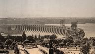
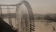
The Dnjepr power dam, still undamaged:
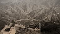
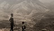
The Long Wall, northern China:
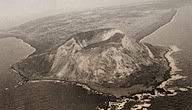
Iwo Jima from the air:
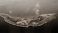
Wotje Island, under air attack (unfortunately I could't find any older suitable imagery):
Japanese battleship Kirishima, carrier Kaga, and battleship Hiei at Hitokappu Bay, Etorofu, Kurile Islands:
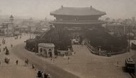
Seoul, before the war:
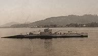
US submarine S-30 near the coast of Zamboanga, the Philippines:
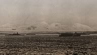
The Bismarck Range, in New Guinea:
Enjoy, and feedback is appreciated!
Latest additions:
- Full coverage for the USA;
- Full coverage for Canada;
- Full coverage for the Japanese Home Isles, and partially the Japanese overseas territories;
- Full coverage for Romania;
- Partial coverage for the Philippines;
- Partial coverage for the Dutch East Indies;
- As well as some other bits and pieces scattered around the globe.
Here are a few highlights:
The Dnjepr power dam, still undamaged:
The Long Wall, northern China:
Iwo Jima from the air:
Wotje Island, under air attack (unfortunately I could't find any older suitable imagery):
Japanese battleship Kirishima, carrier Kaga, and battleship Hiei at Hitokappu Bay, Etorofu, Kurile Islands:
Seoul, before the war:
US submarine S-30 near the coast of Zamboanga, the Philippines:
The Bismarck Range, in New Guinea:
Enjoy, and feedback is appreciated!
Basically having high standards, and do a lot of Googling...  But part of the equation is looking for imagery that represents the terrain if even remotely possible, is preferably pre-war or early war, makes an interesting image. If there's some 'evidence' of the actual vintage of the image, then that I tend to consider a bonus. Old cars, ships, buildings long lost, stuff like that. Mind you, the terrain is all-important, but these tell-tale signs (for me at least) are the bits of proof to ooze they're genuine in respect to the era. In the case I have to revert to more modern imagery (as Baffin Island isn't exactly your tourist hot spot, for one) I try to grain the image a wee bit, to try to age it somewhat.
But part of the equation is looking for imagery that represents the terrain if even remotely possible, is preferably pre-war or early war, makes an interesting image. If there's some 'evidence' of the actual vintage of the image, then that I tend to consider a bonus. Old cars, ships, buildings long lost, stuff like that. Mind you, the terrain is all-important, but these tell-tale signs (for me at least) are the bits of proof to ooze they're genuine in respect to the era. In the case I have to revert to more modern imagery (as Baffin Island isn't exactly your tourist hot spot, for one) I try to grain the image a wee bit, to try to age it somewhat.
Last edited:
And all that, I'm afraid to say, is typical of how CORE does things. They're a scary mob over there.
Well you'd better... Especially considering the time we spend on doing it. Why bother messing with it otherwise? But, as you should know Epa, we might be scary at first glance, but cuddly once you get close.
Why bother messing with it otherwise? But, as you should know Epa, we might be scary at first glance, but cuddly once you get close. Cuddly - like a koala with a razor. No, I do but jest. The site's well worth a visit just to see the deatil that goes into their modelling - and the cuddles.
The new B&W and Color graphics packs have been released including the 0.4 release of the travel guide... I will update this thread pretty soon, but that will most likely take me a few days given my agenda. Release 0.4 includes a lot of new imagery in the Pacific Rim: Australia, and many an atoll or island in the Pacific is now included. I can fully understand Clive Howard for naming his book regarding their efforts of the 7th Air Force in WWII 'One Damned Island After Another'...


Great find! It would be helpful if you disclose who the owner of the photos is so that Hagar has easier time putting them in the mod.
I can point out the webpages were these pictures were taken from:
Iquitos/ Ucayali (very similar in reality: rainforest + Amazon river
http://dawnontheamazon.com/blog/
http://dawnontheamazon.com/blog/201...om-recovering-history-in-the-peruvian-amazon/
Lima
http://www.bigtravelweb.com/travel/2008/11/25/photos-of-latin-life-100-years-ago/
Santiago
http://www.fund-edlb.org/postales.htm
Piura/ Trujillo --> better picture (less urban) attached
http://piuraantiguo.blogspot.com/
Cuzco
http://www.mountlehmanllamas.com/trivia24.html
Arequipa --> second webpage has many pictures, the best in my opinion for Arequipa is the one attached
http://brianpink.tripod.com/trivia100.html
http://www.skyscrapercity.com/showthread.php?t=399160
Attachments


Pto Montt
http://www.diariollanquihue.cl/prontus4_nots/site/artic/20050326/pags/20050326010637.html?0.5?0.5
Antofagasta (better pictures, not too urban)
http://pamir.chez-alice.fr/Voiliers/Classe_A/Pamir/Harbors/Antofage.htm
http://www.diariollanquihue.cl/prontus4_nots/site/artic/20050326/pags/20050326010637.html?0.5?0.5
Antofagasta (better pictures, not too urban)
http://pamir.chez-alice.fr/Voiliers/Classe_A/Pamir/Harbors/Antofage.htm
Nice images, kstanb! I'm sure several of them will find their way into the travel guide.
Version 5 is up! Attention remains at the Pacific, where the last Japanese sections surrendered to the camera. Now the camera is clicking all around China...
Here are some examples of version 5:
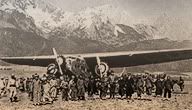
Xiaguan, Yunnan:
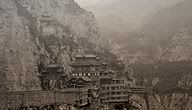
Taiyuan, Shanxi:
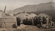
Ulan Bator, Mongolia:
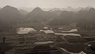
Wenshan, Yunnan:
Nanyang, Nationalist China:
Enjoy!
Here are some examples of version 5:
Xiaguan, Yunnan:
Taiyuan, Shanxi:
Ulan Bator, Mongolia:
Wenshan, Yunnan:
Nanyang, Nationalist China:
Enjoy!