

Hey there,
I've seen a few map-overhauls of the Balkans months ago, but those are not updated. So I decided to make my own suggestion based on those others.
Why the thread in the first place? Well, Cradle of Civilization updated Anatolia (among other regions) and it really shows how old and blocky the Balkans are next to it. Rumelia (Ottoman-controlled Thrace and some other parts of the Balkans) was a very rich and populous province for the Ottoman Empire; the current setup doesn't do it justice.
let's discuss!
EDITED: Updated with my suggestion for mainland (Ottoman) Greece.
EDITED: Updated with my suggestion for Moldavia.
EDITED: Updated with my suggestion for Wallachia.
EDITED: Updated with my suggestion for Bulgaria.
EDITED: Updated with my suggestion for Crete and Cyprus.
EDITED: Updated with a table and 3 maps (terrain, trade-goods and culture). Also added a proposition with an extra new province.
EDITED: Updated with 2/3 of the sources for terrain, trade-goods and cultures.
Province-borders of the propositions can and will be adjusted in the end-result (because of revisions and/or feedback).
The end-result looks like this at the moment:

I also added an alternate version. It's kind of odd to have a coastal province like Varna include so much of Bulgaria's interior. Sliven was also an important town and a Sanjak of its own, so I decided to add this province in this alternate version. I also adjusted the borders of Athens and Tirhala again, to make sure that the city of Amfissa/Salona is under Ottoman control.
Here's the alternate version (and my personal favorite, too):

The provinces in Bulgaria are not really smaller than the newest ones in England or Poland, so I hope that might give this suggestion a bit more credibility
Maps for culture, terrain and trade-goods for the normal version:


 Here's a table with all the information about the provinces. The star indicates the alternate proposition (with the new province of Islimiye / Sliven):

Religion was not a real surprise; the majority of this region practiced the Orthodox version of Christianity. I've also changed some dynamic province-names for Albanian provinces, because some cities aren't located in their respective provinces when they get a dynamic name (see: table).
Sources for terrain, trade-goods and cultures:
I've seen a few map-overhauls of the Balkans months ago, but those are not updated. So I decided to make my own suggestion based on those others.
Why the thread in the first place? Well, Cradle of Civilization updated Anatolia (among other regions) and it really shows how old and blocky the Balkans are next to it. Rumelia (Ottoman-controlled Thrace and some other parts of the Balkans) was a very rich and populous province for the Ottoman Empire; the current setup doesn't do it justice.
let's discuss!
EDITED: Updated with my suggestion for mainland (Ottoman) Greece.
EDITED: Updated with my suggestion for Moldavia.
EDITED: Updated with my suggestion for Wallachia.
EDITED: Updated with my suggestion for Bulgaria.
EDITED: Updated with my suggestion for Crete and Cyprus.
EDITED: Updated with a table and 3 maps (terrain, trade-goods and culture). Also added a proposition with an extra new province.
EDITED: Updated with 2/3 of the sources for terrain, trade-goods and cultures.
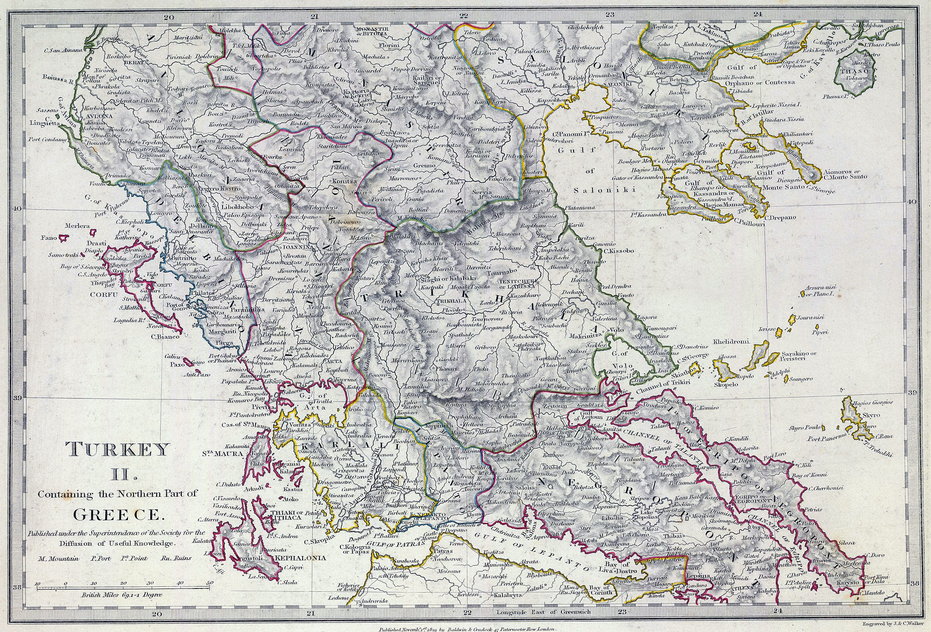
So, here’s my take on Greece, Macedonia and Thrace after a good afternoon of work, based on the following suggestions:
 My Paint-job is not beautiful at all, it’s just a concept. Province-shapes are not final, although some are done for a good reason (explained in the relevant and numbered sections). Numbered provinces indicate some changes to it, or a new province altogether. Black stars indicate that the province is not the most important one to get added (personal opinion). Red dots indicate provincial capitals. Their placement has (obviously) been based off their placement on the worldmap of Google Maps: https://www.google.nl/maps/place/Gr...x363a1775dc9a2d1d!8m2!3d39.074208!4d21.824312
As for sources, I've mostly used Wikipedia, but I’ve been careful to look for the references to make sure it’s not made-up information.
The list of provinces that got tweaked a bit / new additions:
Keep in mind that I've not focused on cultures, religions, terrain-types or tradegoods.
- https://forum.paradoxplaza.com/foru...ces-for-southern-and-eastern-balkans.1016137/ by @Metz
- https://forum.paradoxplaza.com/foru...-new-provinces-in-balkans-and-cyprus.1039388/ by @Dieselface
- https://forum.paradoxplaza.com/forum/index.php?threads/improved-balkans-map.859448/ and https://forum.paradoxplaza.com/forum/index.php?threads/improved-greece-map.858948/ by @Mattymooz
- https://forum.paradoxplaza.com/foru...-new-provinces-in-balkans-and-cyprus.1039388/ by @Dieselface
- https://forum.paradoxplaza.com/forum/index.php?threads/improved-balkans-map.859448/ and https://forum.paradoxplaza.com/forum/index.php?threads/improved-greece-map.858948/ by @Mattymooz
As for sources, I've mostly used Wikipedia, but I’ve been careful to look for the references to make sure it’s not made-up information.
The list of provinces that got tweaked a bit / new additions:
1: Yanya (Turkish) / Epirus. Capital: Yanya (Turkish) / Ioannina. Borders have been adjusted to make some room for an Aetolia province. It’s capital has also been moved to the right place. No other changes to it. Culture: Greek.
2: Aetolia / Karli-Eli (Turkish). Capital: Arta / Narda (Turkish). The much requested province for the remnants of the Despotate of Epirus tag. Culture: Greek.
At the gamestart, Carlo II Tocco rules what is left of the despotate of Epirus and also Cephalonia; having lost Ioannina a few years earlier to the Ottomans (lost in 1430). He still controls the cities/fortresses of Arta and Rogoi (lost in 1449), Angelokastron (lost in 1460) and Vonitsa (lost in 1479). He was succeeded by his son, Leonardo III Tocco, in 1448. Epirus should, obviously, have a core on their name-sake province. They were essentially a vassal to the Ottomans, but as the Ottomans proved to be opportunistic and made war on the Tocco-family, I don’t think vassal-status is the way to go in-game. Other tags were also historical vassals of the Ottomans (most of the Balkan-tags, even), but those aren’t represented in-game, too. The new Epirus-tag should have Neapolitan culture, as the family originally hailed from the Kingdom of Naples. It’s mentioned that several illegitimate sons of Carlo II Toco’s uncle ruled some parts of Acarnania in name of the Ottomans, but it’s not specified which regions/towns are under their control. So, those are neglectable for in-game portrayal, in my opinion.
Why add an Epirus-tag in the first place? Well, they posessed more than one city/fortress and still had diplomatic ties to the Byzantines, Ottomans, Neapolitans and Venetians (good, bad or otherwise). They also have a good historical basis in the region.
Why call the province Aetolia? The posessions of the Tocco family were mostly located in the historical Aetolia region, while some others were in Acarnania. It’s a hard choice to make, as neither one is more or less correct than the other. The city of Arta isn’t located within the historical boundaries of Aetolia or the modern ones of Aetolia-Acarnania (but in Epirus), so Arta could be used as the province-name, too. A counter-argument for this could be that Arta was conquered quite soon after the starting-date and that the next capital (Angelokastron) was located in Aetolia, making Aetolia the better option out of the three.
The origin of the Ottoman-Turkish name for the province (Karli-Eli, meaning the ‘Land of Charles’ (Italian: Carlo)) has everything to do with the Tocco family, as it was named after either Carlo I Tocco, or Carlo II Tocco. It was a Sanjak (Ottoman provincial unit) from the 15th century till the Greek War of Independence; one of the reasons why this province should definetely be in-game.
- General history of the Despotate: https://en.wikipedia.org/wiki/Despotate_of_Epirus
- The Tocco Chronicles; depicting the rise of the Despotate in the periods of 1375-1425: https://en.wikipedia.org/wiki/Chronicle_of_the_Tocco
- Leonardo II Tocco, brother of Carlo I Tocco. Information about Epirote conquests and battles with the Ottomans as well as other diplomatic contacts with the Italians/Byzantines: https://en.wikipedia.org/wiki/Leonardo_II_Tocco
- Carlo II Tocco, ruler of Epirus in the 1444 start-date: https://en.wikipedia.org/wiki/Carlo_II_Tocco
- Leonardo III Tocco, Carlo II’s son and heir: https://en.wikipedia.org/wiki/Leonardo_III_Tocco
- Some more history about the Tocco-family in general: https://en.wikipedia.org/wiki/Tocco_family
- The towns/fortresses on the mainland under Tocco-control: https://en.wikipedia.org/wiki/Rogoi https://en.wikipedia.org/wiki/Angelokastro,_Aetolia-Acarnania https://en.wikipedia.org/wiki/Arta,_Greece https://en.wikipedia.org/wiki/Vonitsa
- The Sanjak of Karli-Eli: https://en.wikipedia.org/wiki/Karli-Eli
- Historical Acarnania: https://en.wikipedia.org/wiki/Acarnania
- Historical Aetolia: https://en.wikipedia.org/wiki/Aetolia
- Modern Aetolia-Acarnania: https://en.wikipedia.org/wiki/Aetolia-Acarnania
3: Cephalonia (or Kefalonia) / Kefalonya (Turkish). Capital: Castle of Agios Georgios. The Ionian islands of Cephalonia, Ithaki, Zakynthos and Lefkada combined in one province.
The County Palatine of Cephalonia and Zakynthos was a part of the Kingdom of Sicily. The titles passed on to the Tocco family in 1357. While technically a part of the Kingdom of Sicily, the Tocco’s made sure they were independent from virtually everyone in their vicinity. Venice managed to claim these islands in the span of a few centuries.
The game depicts these islands already under indirect Venetian control (through their vassal; Corfu). Which is not historically correct, as Venice conquered these islands from the Ottomans/Tocco’s in the late 15th century, after the start-date. The islands are big enough to host their own province (together they’re bigger than Corfu). They should be under the control of the Despotate of Epirus, under Tocco rule.
- The County Palatine of Cephalonia and Zakynthos: https://en.wikipedia.org/wiki/County_Palatine_of_Cephalonia_and_Zakynthos
4: Achaea. Minor change to its borders (to reflect the split between the Palaiologos brothers) and its capital. Glarentza should be its capital, instead of Nafplio (which was under Venetian control).
5: Morea. Moved the city of Mystras to the right location, as well as some adjustments to its borders. Also added Corinth in the latest update.

5: Morea. Moved the city of Mystras to the right location, as well as some adjustments to its borders. Also added Corinth in the latest update.
- The Morean despotates ca. 1450: https://en.wikipedia.org/wiki/Despotate_of_the_Morea
6: Tirhala (Turkish) / Trikala/Thessaly. Capital: Tirhala / Trikala. This province has gotten some minor tweaks: First of all, the current capital in-game is Larissa. While technically not incorrect, it only became the capital of the Sanjak of Tirhala in the 18th century. The province’s namesake city Tirhala fulfills this better. The location of the city has also been changed, as it neither reflected Tirhala’s or Larissa’s position on the map of Greece.
I also incorporated a bit of Athens into the province, as the city of Lamia (located there) was already under Ottoman control.
Tirhala is mostly situated in the Thessaly region, so the non-Turkish name for the province could easily be Thessaly (if it’s not already).
I also incorporated a bit of Athens into the province, as the city of Lamia (located there) was already under Ottoman control.
Tirhala is mostly situated in the Thessaly region, so the non-Turkish name for the province could easily be Thessaly (if it’s not already).
- Trikala: https://en.wikipedia.org/wiki/Trikala
- Sanjak of Tirhala: https://en.wikipedia.org/wiki/Sanjak_of_Tirhala
- Lamia: https://en.wikipedia.org/wiki/Lamia_(city)
- Sanjak of Tirhala: https://en.wikipedia.org/wiki/Sanjak_of_Tirhala
- Lamia: https://en.wikipedia.org/wiki/Lamia_(city)
7: Kesriye (Turkish) / Kastoria. Capital: Kesriye (Turkish) / Kastoria. Not many changes, except for the correct placement of its city.
Some other suggestions have supplanted Kesriye for the town of Servia, I don’t know the reasoning for this, but either Kastoria or Servia is fine (as they’re too close to each other to fit both). It depends on the fact whether the developers want to keep the Kesriye-province in or not.
Some other suggestions have supplanted Kesriye for the town of Servia, I don’t know the reasoning for this, but either Kastoria or Servia is fine (as they’re too close to each other to fit both). It depends on the fact whether the developers want to keep the Kesriye-province in or not.
- Kastoria: https://en.wikipedia.org/wiki/Kastoria
- Servia: https://en.wikipedia.org/wiki/Servia,_Greece
- Servia: https://en.wikipedia.org/wiki/Servia,_Greece
8: Manastir (Turkish) / Bitola. Capital: Manastir (Turkish) / Bitola. Returned from the death and split from Skopje, which was just too big in my opinion. Part of the historical Sanjak of Ohrid. Why name the province Manastir instead of Ohrid then? Well, the county-town of the Sanjak was Manastir for a long time. Also the reason why the Sanjak gets to be called the Sanjak of Manastir in some sources. Manastir is also the bigger one out of the two cities and got more historical prominence in the 19th century.
Another user made the suggestion to make a province out of Veles (Koprulu), I didn’t copy this suggestion as Manastir was historically more important (as its own administrative unit) and Veles was part of the Sanjak of Üsküp.
9: Üsküp (Turkish) / Skopje. Capital: Üsküp (Turkish) / Skopje. While the borders are still wonky (just a concept-version, mind you), the placement of its provincial city was just wrong and had to be fixed. Not much to add apart from that.
Another user made the suggestion to make a province out of Veles (Koprulu), I didn’t copy this suggestion as Manastir was historically more important (as its own administrative unit) and Veles was part of the Sanjak of Üsküp.
- Sanjak of Ohrid: https://en.wikipedia.org/wiki/Sanjak_of_Ohrid
- Bitola: https://en.wikipedia.org/wiki/Bitola
- Ohrid: https://en.wikipedia.org/wiki/Ohrid
- Veles: https://en.wikipedia.org/wiki/Veles,_Macedonia
- Bitola: https://en.wikipedia.org/wiki/Bitola
- Ohrid: https://en.wikipedia.org/wiki/Ohrid
- Veles: https://en.wikipedia.org/wiki/Veles,_Macedonia
10: Selanik. Redrew its god-ugly borders to make space for some other provinces.
11: Siroz (Turkish) / Serres. Capital: Siroz (Turkish) / Serres. Selanik is just too ugly and big to leave as it is. It was the capital of the Theme of Strymon when it was in Byzantine hands once. Serres, while not as important as other towns, had its own mint since 1413/1414. It became a beylik within the Sanjak of Selanik later on. It became its own Sanjak (Sanjak of Siroz) in 1846.
Another suggestion in its place could be Drama, although it was smaller than Serres and was part of it’s Sanjak for a while after EU4’s end-date. Although it's currently not located within the borders of my final version.
Some other suggestions called this province ‘Struma’, after its river. I think Serres is the better option compared to Struma, as there is also no Rhine or Danube-province.
- Serres: https://en.wikipedia.org/wiki/Serres
- Drama: https://en.wikipedia.org/wiki/Drama,_Greece
- Sanjak of Siroz: https://en.wikipedia.org/wiki/Sanjak_of_Siroz
- River Struma: https://en.wikipedia.org/wiki/Struma_(river)
- Theme of Strymon: https://en.wikipedia.org/wiki/Strymon_(theme)
- Drama: https://en.wikipedia.org/wiki/Drama,_Greece
- Sanjak of Siroz: https://en.wikipedia.org/wiki/Sanjak_of_Siroz
- River Struma: https://en.wikipedia.org/wiki/Struma_(river)
- Theme of Strymon: https://en.wikipedia.org/wiki/Strymon_(theme)
12: Gümülcine (Turkish) / Komotini. Capital: Gümülcine (Turkish) / Komotini. Just like Selanik, Edirne is just too big and ugly. It has to be split. Gümülcine is the best suggestion, I think. As, just like Siroz, it became its own Sanjak (the Sanjak of Gümülcine) in 1846. It also was an important hub between Constantinople and the European posessions of the Ottomans.
The nearby town of Xanthi became important in the 18th century because of its high-quality tobacco, this could be an alternative for a Komotini-province.
The nearby town of Xanthi became important in the 18th century because of its high-quality tobacco, this could be an alternative for a Komotini-province.
- Komotini: https://en.wikipedia.org/wiki/Komotini
- Sanjak of Gümülcine: https://en.wikipedia.org/wiki/Sanjak_of_Gümülcine
- Xanthi: https://en.wikipedia.org/wiki/Xanthi
- Sanjak of Gümülcine: https://en.wikipedia.org/wiki/Sanjak_of_Gümülcine
- Xanthi: https://en.wikipedia.org/wiki/Xanthi
13: Gelibolu (Turkish) / Gallipoli. Capital: Gelibolu (Turkish) / Gallipoli. As I said earlier; Edirne is too big. Gelibolu was the first Ottoman stronghold in Europe and was a major strategic location. It was its own Sanjak, the Sanjak of Gelibolu. It might be too small for the developers’ standards, that’s why I kept it ‘optional’ (it was very important, though).
14: Edirne: Its size got adjusted with the addition of Gelibolu and Gümülcine. One minor thing, though: Kirkkilise is actually a part of the in-game Edirne-province and too small to warrant its own province, so it should be named to something else (will come later with a Bulgaria-suggestion). Edirne is landlocked in my latest version.
- Gelibolu: https://en.wikipedia.org/wiki/Gelibolu
- Sanjak of Gelibolu: https://en.wikipedia.org/wiki/Sanjak_of_Gelibolu
- Sanjak of Gelibolu: https://en.wikipedia.org/wiki/Sanjak_of_Gelibolu
- Kirkkilise: https://en.wikipedia.org/wiki/Kırklareli
15: Lesbos / Midilli (Turkish). Capital: Mytilene / Midilli (Turkish). Lesbos and the other encircled islands (Lemnos, Thasos, Imbros and Samothrace) were under the control of the Genoese Gattilusio family until they were conquered by the Ottomans. They were nominal vassals of the Byzantines once and did rely on Genoese military help, so I suggest making them a high-autonomy province controlled by Genoa. Not the most important province, as I think the islands could easily be incorporated into the Chios-province, but it would be nice, nonetheless.
- Gattilusi family: https://en.wikipedia.org/wiki/Gattilusi
- Lesbos: https://en.wikipedia.org/wiki/Lesbos
- Mytilene: https://en.wikipedia.org/wiki/Mytilene
- Lesbos: https://en.wikipedia.org/wiki/Lesbos
- Mytilene: https://en.wikipedia.org/wiki/Mytilene
16: Corfu. It’s in-game ruler is actually the ruler of the Despotate of Epirus (the founder of the dynasty controlled Corfu once as a governor, but not anymore). It being a vassal is also strange, as it was fully incorporated into Venetian domains. The in-game Corfu-province also controls the other Ionian islands, which should be given to the Tocco-family ruling Arta (see #2 and #3, respectively).
- Corfu: https://en.wikipedia.org/wiki/Corfu
- The Tocco governor of Corfu: https://en.wikipedia.org/wiki/Guglielmo_Tocco
- The Tocco governor of Corfu: https://en.wikipedia.org/wiki/Guglielmo_Tocco
Coming up with an updated version of Moldavia was not very easy, as I struggled with the following things:
- The EU4 version has bad borders; they don’t correspond with the ones of the principality in some areas.
- The placement of the rivers and some towns in EU4 is not entirely correct, making it hard for me to pinpoint where the (new) towns should be placed correctly.
- Moldavia didn’t have big urban areas, so it’s hard to decide which town gets implemented and which one doesn’t.
So, to deal with this I started with the following map of important/strategic towns in Moldavia (and its surroundings):
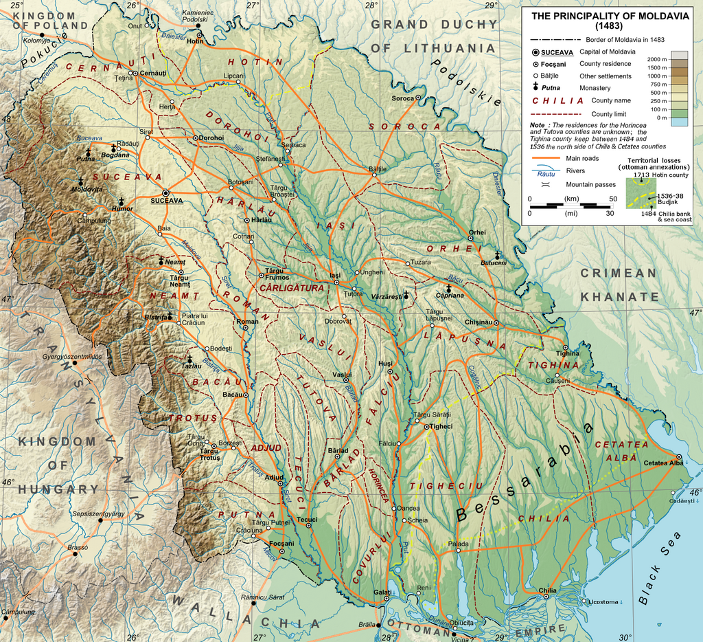
 I based all of this on the following map neatly portraying the administrative divisions (counties) of Moldavia in 1483, as well as territorial gains made by the Ottomans later on:
 The towns/fortresses I explicitly numbered are as follows:
Aiming for the inclusion of some of these towns was partially because of the Moldavia update for CK2:
 Just beautiful. I want something similar in EU4. Make it happen devs!
After mapping the towns, I aimed to make the provinces while keeping the county-borders in mind. I was trying to aim for four to five provinces in total, as Moldavia wasn’t densely populated or urbanized. I did my best to aim for historical borders, also corresponding to the partitions this region had during EU4’s timeline.
Historical divisions I kept in mind:

 My proposition (on county-map):
 My proposition (in-game):
 I've tried my best to be as accurate as possible with Google Maps and Paint, but the placement of the borders/towns may not be 100% correct (I'm no professional), nor does it look beautiful or anything. It's just a concept.
Things I didn't cover:
- Development
- Tradegoods
- Terrain
- Cultures
- Religion
- The EU4 version has bad borders; they don’t correspond with the ones of the principality in some areas.
- The placement of the rivers and some towns in EU4 is not entirely correct, making it hard for me to pinpoint where the (new) towns should be placed correctly.
- Moldavia didn’t have big urban areas, so it’s hard to decide which town gets implemented and which one doesn’t.
So, to deal with this I started with the following map of important/strategic towns in Moldavia (and its surroundings):
1: Tulcea/Tolcu: Although not under Moldavian or Wallachian control in 1444, this town warrants its own province either in the form of Dobruja (geographical name) or just as Tolcu (Turkish name of the town). This region was under Ottoman control since the 1420’s. Many suggestions have been made for this province in other threads.
2: Chilia/Kilia: Important stronghold at the mouth of the Danube. It’s currently the provincial capital of the Basarabia province. Although founded by Stephen the Great (who didn’t rule Moldavia yet) to counteract the Ottoman stronholds on the other side of the river, it’s important enough later on in the timeline to keep it as such in-game. It’s current placement is on the wrong bank of the river, though.
3: Cetatea Alba/Akkerman/Asprokastron: Another important fortress in the Basarabia region, was one of the more important towns of Moldavia for a while, even. Conquered by the Ottomans, with the rest of Basarabia (including Chilia), in 1484. Might be a better provincial capital for the Basarabia province if necessary.
4: Tighina/Bender: Another important fortress, again… Although, not at game-start. The castle was made by the Ottomans, after they conquered it in 1538. It was used to keep pressure on the region. It’s placement on the map shows how wrong the current Tighina province is.
5: Galati/Galaz: While not very spectacular at game’s start, it grew out to be Moldavia’s most important port after the other ones, including Chilia, were conquered by the Ottomans.
6: Bacau: A trading town, also settled by Hungarians. Mentioned here because of its inclusion in CK2.
7: Targu Neamt: Personal favorite, but a bit of a confusing one, as there are three ‘Neamt’s’ in the region: The Neamt monastery and two towns (Targu Neamt and Piatra Neamt; also called Piatra lui Craciun). These towns were some of the first urban ones of Moldavia. The county is also known for it’s castle and the Stephen’s Tower (built in the late 15th century).
8: Iasi: Town that already existed a while before the game’s start. It became the capital city of the principality around 1564. This should be represented in the game somehow.
9: Suceava: Capital city at the game’s start (so, it’s current placement on the in-game EU4-map is clearly wrong) and also the main residence for the Moldavian princes. Suceava and its surrounding were conquered by the Austrians later on (the Bukovina), so it definetely warrants its own province.
10: Chisinau: The capital city of Moldova nowadays. Although it was just a village/small town at the beginning of EU4, it later grew out to be an important city. I’m of the opinion that it should be the name of a province to the east of the river Prut; an area which was later conquered by the Russian Empire.
11: Hotin: The castle was taken by the Polish, so it’s not under Moldavian control. While it was reconquered later on and even occupied by the Ottomans in 1713, I think it’s too small to warrant its own province.
- https://en.wikipedia.org/wiki/Dobruja (states that the Ottomans held these lands after 1420)
- https://en.wikipedia.org/wiki/Isaccea (another town in the Dobruja region; the article links to a source stating that the Ottomans held these lands after the crusade of Varna).
- https://upload.wikimedia.org/wikipedia/commons/4/4c/Dobrudja_topographic_map-en.svg (map of the Dobruja, includes both the towns of Tolcu and Isaccea)
3: Cetatea Alba/Akkerman/Asprokastron: Another important fortress in the Basarabia region, was one of the more important towns of Moldavia for a while, even. Conquered by the Ottomans, with the rest of Basarabia (including Chilia), in 1484. Might be a better provincial capital for the Basarabia province if necessary.
4: Tighina/Bender: Another important fortress, again… Although, not at game-start. The castle was made by the Ottomans, after they conquered it in 1538. It was used to keep pressure on the region. It’s placement on the map shows how wrong the current Tighina province is.
5: Galati/Galaz: While not very spectacular at game’s start, it grew out to be Moldavia’s most important port after the other ones, including Chilia, were conquered by the Ottomans.
6: Bacau: A trading town, also settled by Hungarians. Mentioned here because of its inclusion in CK2.
7: Targu Neamt: Personal favorite, but a bit of a confusing one, as there are three ‘Neamt’s’ in the region: The Neamt monastery and two towns (Targu Neamt and Piatra Neamt; also called Piatra lui Craciun). These towns were some of the first urban ones of Moldavia. The county is also known for it’s castle and the Stephen’s Tower (built in the late 15th century).
9: Suceava: Capital city at the game’s start (so, it’s current placement on the in-game EU4-map is clearly wrong) and also the main residence for the Moldavian princes. Suceava and its surrounding were conquered by the Austrians later on (the Bukovina), so it definetely warrants its own province.
10: Chisinau: The capital city of Moldova nowadays. Although it was just a village/small town at the beginning of EU4, it later grew out to be an important city. I’m of the opinion that it should be the name of a province to the east of the river Prut; an area which was later conquered by the Russian Empire.
11: Hotin: The castle was taken by the Polish, so it’s not under Moldavian control. While it was reconquered later on and even occupied by the Ottomans in 1713, I think it’s too small to warrant its own province.
After mapping the towns, I aimed to make the provinces while keeping the county-borders in mind. I was trying to aim for four to five provinces in total, as Moldavia wasn’t densely populated or urbanized. I did my best to aim for historical borders, also corresponding to the partitions this region had during EU4’s timeline.
Historical divisions I kept in mind:
1: Dobruja/Tolcu: As I explained earlier; the Dobruja was part of the Ottoman Empire. Tolcu was an important town there, so it’s also the provincial capital.
2: Basarabia: Cut out the Ottoman part, but gave the fortress of Tighina/Bender to the province to reflect the Ottoman conquest of Basarabia (Tur: Akkerman). Kept Chilia as its provincial capital.
3: Galaz: Decided to go for Galaz instead of Bacau, as it was an important trading port on the Danube. Could be merged with 4 (Iasi) and renamed to Iasi if it’s too small to warrant its own province. Galaz is obviously its provincial capital. Encircled a mountain-pass into Transylvania on the county-map.
4: Iasi: Future capital city of the principality. Could be merged with 3 (Galaz) if it’s too small, but it should keep the name. Has a bigger concentration of urban towns (like Neamt), so could have more development than most of Moldavia. Also the provincial capital. Encircled a mountain-pass into Transylvania on the county-map.
5: Suceava: Current capital city of the principality. I made its borders in such a way to reflect the Habsburg territory of Bukovina. Its provincial capital could change to the town of Czernowitz (German name of Cernauti) if conquered by the Austrians. Encircled a mountain-pass into Transylvania on the county-map.
6: Chisinau: Changed the old Tighina province to Chisinau, as well as changing the placement of its provincial capital (also Chisinau). Soroca or Orhei (both encircled on the county-map) could also be used as province-names and provincial capitals if Chisinau is too small for a town to warrant inclusion.
Things I didn't cover:
- Development
- Tradegoods
- Terrain
- Cultures
- Religion
Coming up with a suggestion for Wallachia was easier than for Moldavia. Things I kept in mind while making this:
- It’s hard to draw new provinces for Wallachia while not making some kind of checker-board.
- Wallachia ‘deserves’ 5-6 provinces in total, just like its neighboring princedoms and kingdoms.
- It’s not 100% known if Bucharest existed at the game’s start, but it sure deserves its own province, as it became the Wallachian capital later during the game.
- The map of EU4 is a little bit twisted to let Europe look larger than it really is (among some other things, like the position of South America). This is done for gameplay-reasons, but makes placement of borders, rivers and towns a little harder.
- It’s impossible to depict every important town as its own province, especially if a few of them are very close to each other.
As usual, I will show my proposition and explain why I made these decisions.
My proposition on Wallachia (and some tweaks to Transylvania):
 Important or noteworthy towns/fortresses are displayed with red dots. White numbers indicate the provinces I drew (six in total, so 3 more in total). The exclamation mark indicates a small tweak for a provincial capital (Maros).
I mostly tried to adhere to this map depicting the counties of Wallachia during the 17th century:
 Also inspired by CK2’s recent update for Wallachia:
 I numbered the following towns/fortresses:
 Last but not least; the provincial capital of Maros (in Transylvania) should be named Székelyvásárhely, as Targu Mures is a quite modern name for the same city. A very minor thing, I admit, and sources are sadly scarce.
I used the county-map again to make the provinces. As you can see, I tried to take the county-borders into account, as well as the river Olt.
 The provinces are simply named after their most important cities (which I discussed earlier):
1: Targu Jiu
2: Craiova
3: Tirgoviste
4: Bucuresti
5: Buzau
6: Braila
Things I didn't cover:
- Development
- Tradegoods
- Terrain
- Cultures
- Religion
- It’s hard to draw new provinces for Wallachia while not making some kind of checker-board.
- Wallachia ‘deserves’ 5-6 provinces in total, just like its neighboring princedoms and kingdoms.
- It’s not 100% known if Bucharest existed at the game’s start, but it sure deserves its own province, as it became the Wallachian capital later during the game.
- The map of EU4 is a little bit twisted to let Europe look larger than it really is (among some other things, like the position of South America). This is done for gameplay-reasons, but makes placement of borders, rivers and towns a little harder.
- It’s impossible to depict every important town as its own province, especially if a few of them are very close to each other.
As usual, I will show my proposition and explain why I made these decisions.
My proposition on Wallachia (and some tweaks to Transylvania):
I mostly tried to adhere to this map depicting the counties of Wallachia during the 17th century:
1: Severin: Built by the Kingdom of Hungary in the 11th century to keep an eye on the Bulgarians. This fortress was a reason for war between Hungary and the Oltenian voivodes for a few generations. The Hungarians eventually made a Banat out of it and passed into Wallachian control a while later, when it became an autonomous country. It came under renewed Ottoman attack after the fall of Constantinople, so the townsfolk decided to move their livelihoods to a village more to the north of Severin. I chose this province instead of Targu Jiu, because the latter was first mentioned in the early 15th century and doesn’t seem to hold more strategic value than the fortress at Severin. Although it wouldn’t be strange to use Targu Jiu as province-name (and in-game provincial capital) instead, as Severin seems to have been burned down in the late 15th century and Targu Jiu’s economic potential was bigger. So, both options are viable. EDIT: I went for Targu Jiu in my latest version, because of its economic power and added the county of Severin to Craiova.
2: Craiova: Second town I will cover and the second province for Wallachia. It already exists in-game as the (rightful) provincial capital of Oltenia. While not really special at the game’s start, it grew out to be an important economic center for Wallachia and was referred as a ‘city’ later on. Also the seat of power of the important Craiovesti family.
3: Turnu Magurele: Won’t be a province, but still deserves a mention. Conquered and occupied by the Ottomans a few decades before 1444. The fortress was usually used to keep pressure on Wallachia and keep traffic on the Danube in check.
4: Giurgiu: Just like Turnu Magurele also a fortress occupied by the Ottomans to keep traffic on the Danube in check. Both fortresses weren’t reclaimed by Wallachia during EU4’s timeframe, so that’s why I made two small bites out of Wallachia to represent both of them.
5: Pitesti: Wallachians princes have been known to inhabit this town. It grew out to a be a decently sized city, but Targoviste is too close by to make a province out of it.
6: Campulung: Old capital of Wallachia and one of its earliest urban towns. There was considerable contact and trade with Transylvania. Campulung’s importance gradually declined in the following centuries and gave way to Tirgoviste and Bucuresti subsequently; that’s why it’s not its own province.
7: Targoviste: Current (1444) capital of Wallachia, but declined as the seat was moved to Bucharesti. Explains its inclusion by itself, I hope.
8: Bucuresti: Difficult one to add, as it wasn’t an important town in the beginning of EU4 (it might not have existed in 1444). Vlad III ‘The Impaler’ moved his court here around 1459, but it only officially became the Wallachian capital after 1698.
9: Buzau: Already mentioned during the reign of Dan II (so, a decade or more before 1444) as a market-town. It was already flourishing in 1431. Disasters struck the town in the 17th and 18th century, but it kept reappearing and recovering. Is already in-game, which makes absolute sense.
10: Braila: Already mentioned in documents before 1444. A town on the banks of the Danube that grew when Genoan holdings on the Danube started to disappear. It was the principality’s main harbour. The Ottomans conquered it around 1540 and called it Ibrail. They held onto it till 1829. While the Ottomans only controlled a small part of my proposed Braila-province after 1540, I think it’s more important than the likes of Hotin (in Moldavia) or other small fortresses and holdings, so I decided to make it larger than the county historically was (by adding the county of Ialomita to it and a small part of Buzau). It was an important and populated port, after all. Unlike some border-fortresses or strongholds. It just doesn't reflect its future-conquest by the Ottomans.
11: Brasov/Kronstadt: Located in Transylvania and obviously not a Wallachian town. The reason why I included it in this suggestion is because Brasov was actually a quite important and wealthy Saxon town, but it’s not reflected this way in EU4. The location of Brasov is currently occupied by a part of the Carpathian mountains, while this region was historically well-developed and populated. So, I think it should be a part of the Kiralyfold (‘King’s Land’) region of Transylvania. Mountain-passes connect the city with Wallachia. The provincial capital of Kiralyfold (Sibiu) could stay, of course. But some extra development wouldn’t hurt, as there were multitudes of fortified and wealthy Saxon towns in this region.
I used the county-map again to make the provinces. As you can see, I tried to take the county-borders into account, as well as the river Olt.
1: Targu Jiu
2: Craiova
3: Tirgoviste
4: Bucuresti
5: Buzau
6: Braila
Things I didn't cover:
- Development
- Tradegoods
- Terrain
- Cultures
- Religion
One of my last province-suggestions for the Balkan region, and (in my opinion) the hardest one to make: Bulgaria and its surroundings. Some points before we get started:
- All of Bulgaria (except for a small surprise on the coastline) was controlled by the Ottoman Sultanate/Empire from the start to the finish of EU4. So, borders of the old Bulgarian kingdoms or modern ones were a no-go for me.
- I tried looking for Ottoman Sanjaks while making this, as those are regularly more important towns.
- The borders of the Ottoman Sanjaks were not always good options to follow, as they were too big to make good provinces of.
- I had to tweak some borders of my first suggestion for (Ottoman) Greece a bit, for continuity’s sake.
- Bulgaria has 6 provinces, as of patch 1.25. My intention was not to double that by any means, just to add where necessary. So, I managed to create 4 more (excluding the new Macedonian province).
- I used the same tactic as before: pinpointing important/noteworthy towns/strongholds on the EU4 map and making a province-layout after that.
- The Ottomans control 42 provinces after all my suggestions. Slightly more than England does and slightly less than the Mamluks. Acceptable, I think.
- I also used some suggestions of other users as inspiration. Note that I didn’t copy everything, as I simply don’t agree with all their additions (will explain why in the town-section of this suggestion).
So, this is a map of the towns/strongholds I want to highlight, I decided the new provinces from here on out:
 I know; it’s a lot. It was one Hell of a job research all of the towns. You can see that I also pinpointed towns in Greece and Macedonia, this to put the map into perspective and to make sure that the borders are fitting. I mostly used Wikipedia, as usual, but I always made sure to look at the references or to Google a bit further if I deemed that necessary.
So, without further ado:
So, I came up with the following provincial set-up (disclaimer: the final version has the polished borders, those here have been drawn quickly):
 * = already mentioned/shown earlier in my Greece-redraw. Bold = new province.
- All of Bulgaria (except for a small surprise on the coastline) was controlled by the Ottoman Sultanate/Empire from the start to the finish of EU4. So, borders of the old Bulgarian kingdoms or modern ones were a no-go for me.
- I tried looking for Ottoman Sanjaks while making this, as those are regularly more important towns.
- The borders of the Ottoman Sanjaks were not always good options to follow, as they were too big to make good provinces of.
- I had to tweak some borders of my first suggestion for (Ottoman) Greece a bit, for continuity’s sake.
- Bulgaria has 6 provinces, as of patch 1.25. My intention was not to double that by any means, just to add where necessary. So, I managed to create 4 more (excluding the new Macedonian province).
- I used the same tactic as before: pinpointing important/noteworthy towns/strongholds on the EU4 map and making a province-layout after that.
- The Ottomans control 42 provinces after all my suggestions. Slightly more than England does and slightly less than the Mamluks. Acceptable, I think.
- I also used some suggestions of other users as inspiration. Note that I didn’t copy everything, as I simply don’t agree with all their additions (will explain why in the town-section of this suggestion).
https://forum.paradoxplaza.com/forum/index.php?threads/bulgarian-suggestions.1030289/ by @oim8
https://forum.paradoxplaza.com/foru...ces-for-southern-and-eastern-balkans.1016137/ by @Metz
https://forum.paradoxplaza.com/forum/index.php?threads/improved-balkans-map.859448/ by @Mattymooz
https://forum.paradoxplaza.com/forum/index.php?threads/balkans-redraw-redux.1066621/#post-23745084 by @BeyondExpectation
So, without further ado:
1: Plovdiv (Bul.) / Filibe (Tur.): Already in-game as a province (rightfully so). Located on the banks of the Maritsa river. One of the richer towns of the Ottoman Sultanate/Empire and the centre of a Sanjak (Ottoman provincial unit) for most of its existence in the EU4 timeline. It was the centre of the Rumelia Eyalet at the beginning of the game.
2: Sofia (Bul.) / Sofya (Tur.): Just like Plovdiv, also in-game as a province. Surrounded by mountains, it was already an important fortress of the Bulgarians before the Ottomans conquered it in the late 14th century. It’s the centre of its own Sanjak (Sanjak of Sofya) at the game’s start. It had the largest market of the Balkans once, according to 16th century sources. Not entirely in the correct place on the map, so adjusted this a little.
3: Vidin (Bul. / Tur.): Already in-game as a province. It was a port and fortress on the Danube. The Ottomans conquered it in the late 14th century from the Tsardom of Vidin and turned it into its own Sanjak. The Sanjak had some of the most developed shipbuilding in the Ottoman Sultanate/Empire. Its in-game provincial capital is placed in the wrong location, so the red dot marks the correct place of the city of Vidin.
4: Nikopol (Bul.) / Nigbolu (Tur.): Already in-game for the Ottomans as the (Turkish) dynamic province-name for Tarnovo. An important battle was fought here (the battle of Nicopolis) in the late 14th century. It was an important and wealthy city at the banks of the Danube during the first few centuries of Ottoman rule and even its own Sanjak. So, I’m of the opinion that this warrants its own inclusion as a province, separate from Tarnovo. Also renowned for its shipbuilding, just like Vidin.
5: Tarnovo (Bul.) / Tirnova (Tur.): Kind of already in-game (as explained above). It was the old capital of the Bulgarian Empire. Located on the hills above the river Yantra. It was also the centre of a major Bulgarian uprising during Ottoman rule.
6: Varna (Bul. / Tur.): Famous for its namesake battle (that marks the beginning of every EU4-game). It was an important Black Sea port and also became a Sanjak after EU4’s timeline. I think the town was prosperous and famous enough to warrant its own province. The rest of the region has some important towns and places, too, but this one seemed to be the best choice next to Silistra.
7: Silistra (Bul.) / Silistre (Tur.): Already in-game, but the placement of its provincial capital is wrong. Important town on the Danube that was also the centre of its own Sanjak and it even became the centre of its own Eyalet later on.
8: Constanța (Rom.) / Konstantsa (Bul.) / Köstence (Tur.): Was historically an important town on the Black Sea, but its importance declined when the Ottomans took over the region. It only rose in prominence again when it was ceded to Romania long after EU4’s timeline. Some other suggestions have used this town as the provincial capital for a Silistra province or for the Dobruja. I disagree with both of those propositions for the reason stated earlier; it was of no particular importance during Ottoman rule. So, I won’t make a province out of this city, but included it in the Silistre-province.
9: Tulcea (Rom.) / Tulcha (Bul.) / Tolcu (Tur.): Already mentioned in my redraw of Moldavia. Conquered by the Ottomans around 1420 and it was an important centre for transit trade, as it lays close to the Danube. I have decided to make a province out of this city, not using the geographical name of its location (Dobruja). That’s because the Dobruja is actually larger and also includes towns like Constanta and Silistra.
10: Strumica (Mac.) / Ustrumca (Tur.): Small town in what’s nowadays called Macedonia. Was officially part of the Sanjak of Köstendil (although this isn’t reflected in my proposition, as Köstendil would otherwise be too elongated and Üsküp too small) under Ottoman rule. Some suggestions of other users have used this town as its own province. I disagree, as it was too small on its own and always a part of another Sanjak (first Köstendil, later Selanik), not one on its own.
11: Velbazhd (Kyustendil) (Bul.) / Köstendil (Tur.): Part of the Serbian Empire before it was conquered by the Ottomans. It was a town and a centre of a Sanjak (of the Rumelia Eyalet) located between Macedonia and Bulgaria. I decided to make it its own province, as giving it to Üsküp or Sofya would make those two provinces too square-like and/or big, the town was also a Sanjak on the same level as those other two. So, I think it deserves its status as an in-game province. The province would also serve as an extra step for invaders to reach the innermost parts of Rumelia (like Edirne, as there are only two provinces between Edirne and Serbia, for example). I also included it into the Bulgarian sphere instead of the Macedonian one, as the Sanjak was a part of the Nis Eyalet after EU4’s end-date, which didn’t control any Macedonian territories and it’s also a part of Bulgaria nowadays. The southern part of Bulgaria (to the south of the Balkan mountains) is, apart from Sofya, Islimye and Filibe, quite devoid of important towns in this time-period, so this was the best option. On a whole other note; it was also a settlement in the Bulgaria-province in the Empire: Total War videogame.
12: Veles (Mac.) / Köprülü (Tur.): Not a very noteworthy town. Some other suggestion had this one as its own province. I disagree with that decision, as Veles was a township under the Sanjak of Üsküp.
13: Bitola (Mac.) / Manastir (Tur.): Already mentioned in my Greece-rework. Part of the historical Sanjak of Ohrid. Decided to make a province out of it. Why name a new province Manastir instead of Ohrid then? Well, the county-town of the Sanjak was Manastir for a long time. Also the reason why the Sanjak gets to be called the Sanjak of Manastir in some sources. Manastir is also the bigger one out of the two cities and got more historical prominence later on.
14: Skopje (Mac.) / Üsküp (Tur.): Already in-game as a province, but the placement of its provincial capital was just wrong (as I mentioned earlier in my Greece-redraw). Was its own Sanjak and prospered under Ottoman rule. I made sure that Veles is a part of my proposed Skopje-province, as it historically was a part of the Sanjak of Üsküp, too. Also included Strumica, for aesthetical reasons.
15: Ohrid (Mac.) / Ohri (Tur.): Mentioned earlier, but slightly less important than Bitola, so won’t be its own province.
16: Zherkovo (Bul.) / Kircaali (Tur.): Small town in the Rhodope mountains. The article mentions it staying small under Ottoman rule, so I don’t think making it a province (as some other suggestions have done) would be wise. Not very noteworthy, otherwise.
17: Lovech (Bul.) / Lofca (Tur.): The Hisarya fortress eluded capture by the Ottoman authorities a few years after 1444 (although sources remain a bit vague). Some have suggested to make Lovech its own province and its own tag for this reason, but I disagree with both notions. Lovech only became important during the 17th century and only one fortress was occupied, by bandits, nonetheless. Not an important dynasty, a hold-out state or a sizeable chunk of territory to warrant its inclusion in the game. The northern part of Bulgaria would also become too crowded with even more additions.
18: Vratsa (Bul.) / Ivraca (Tur.): An important trading centre under Ottoman rule. Other suggestions had this town as a province, but I disagree with that. There are too many other (more important) provinces in this region (northern Bulgaria) to include it as an in-game province, it also was a part of the Nigbolu Sanjak, so that’s where I put Vratsa.
19: Ruse (Bul.) / Ruscuk (Tur.): Grew out to be a quite important town and fortress after the Ottomans rebuild it. Became the centre of the Danube Vilayet after EU4’s enddate. It wouldn’t be weird to add this town as its own province, as some suggestions did, but there are just too many other (more) important towns/province close by (Silistra, Varna and Tarnovo, for example), which are (just a bit) more important. I included the town into the Varna-province.
20: Pirot (Ser.) / Sehirköy (Tur.): Town in nowadays Serbia. Was conquered by the Ottomans in the end of the 14th century. It was later organized into the Sanjak of Nis. I don’t think it warrants its own province, as it was part of a Sanjak, not one on itself. There was a suggestion that used this town as the provincial capital of a Shopluk province (the Shopi are the inhabitants of this mountainous region). While creative, I haven’t found any source mentioning this region within EU4’s as an Ottoman administrative unit, the boundaries of this region are also very vague. So that’s why I haven’t copied this suggestion.
21: Shumen (Bul.) / Sumen (Tur.): An important Ottoman fortress, it was destroyed after the Crusade of Varna and rebuild in its current location. The largest mosque of Bulgaria was built in the 18th century. Too close to the other important provinces/Sanjaks, so I haven’t made a province out of it. I will try to keep the development of the province where this town is located in account, to make sure it’s not too low. I included the town into the Varna-province.
22: Stara Zagora (Bul.) / Zagra-I Atik (Tur.): Not a very noteworthy town. It was conquered in the 14th century (like most of Bulgaria, obviously). Some articles mention that it was destroyed often and/or stagnated after the Ottomans conquered it. So, no reason to add it in-game.
23: Nesebar (Bul.) / Mesembria (Gr.): Small port town that was regained by the Byzantine Empire after the Ottoman interregnum. Was already discussed somewhere in the suggestion sub-forum. This part of the Bulgarian Black Sea coast (Nesebar, Pomorie, Ahtopol and Sozopol) should be given to the Byzantines at the game’s start.
24: Anhialo (Pomorie) (Bul.) / Ahyolu (Tur.): Also still in Byzantine possession at the game’s start, like Nesebar. Not a very big town on itself, but it received a lot of Byzantine refugees after the fall of Constantinople. Mentioned for its inclusion in the Nesebar-province.
25: Burgas (Bul.) / Burgaz (Tur.): Probably destroyed before the game’s start, or simply too small, but was rebuild later on. The coastal strip was still under Byzantine control till 1453. It became a part of the Islimye Sanjak later on and its importance as a port grew over the centuries. Burgas shouldn’t be its own province. It’s current Turkish dynamic province-name is Kirkkilise, which is wrong, as Kirkkilise is currently placed in the province of Edirne (and still will be in my suggestion). So, I renamed the province to Nesebar and gave it to the Byzantines while also adjusting the borders accordingly. There could be an event flipping the provincial capital to Burgas later on, but Nesebar (as provincial capital) should be fine on itself, too.
26: Sozopol (Bul.) / Sozopolis (Gr.): Also still in Byzantine possession at game’s start, like Nesebar. Some sources say it declined during Ottoman rule, after they took this town in 1453. It seemed to be quite prosperous before that, although sources are not very accurate on this, so I’ll keep that as a maybe.
27: Ahtopol (Bul.) / Ahtenbolu (Tur.): Also still in Byzantine possession at the game’s start, like Nesebar. Not a very important town besides that.
28: Kirkkilise (Tur.) / Lozengrad (Bul.): It shouldn’t be a dynamic province-name for Burgas. It’s actually located in the current province of Edirne, too and was under Ottoman control at the game’s start. I kept it there in my suggestion, as it was quite close to Edirne. Its Muslim population formed a Sanjak. Apart from that not a very noteworthy town, so I decided not to incorporate it into my suggestion.
29: Edirne (Tur.) / Adrianople (Gr.): Already mentioned in the Greece-redraw. Capital of the Ottoman Sultanate at the game’s start. Quite an important city and probably the most fought-over site in the world. I adjusted its borders to make room for more provinces and to make everything a bit more aesthetically pleasing. Not much more to add.
30: Gümülcine (Tur.) / Komotini (Gr.): Already mentioned in my Greece-redraw and also in other folks’ suggestions. Was an important trading hub and also became its own Sanjak after EU4’s end-date. Mentioned in this suggestion because of some border-changes I made. This current suggestion makes more than enough room for both Gümülcine and Siroz to be included.
31: Siroz (Tur.) / Serres (Gr.): Also mentioned in my Greece-redraw. Decided to still mention the town here, as I changed some borders. The town certainly warrants its own province as it was sizable and had its own mint, it even became a Sanjak after EU4’s end-date. It’s also mentioned in other suggestions. As mentioned above, this current suggestion makes more than enough room for both Gümülcine and Siroz to be included.
32: Selanik (Tur.) / Thessaloniki (Gr.): Already in-game, only mentioned here because some borders got changed from my Greece-redraw.
33: Karvuna (Karvana) (Bul.): Honorary mention as it once was the capital of the Principality of Karvuna. Lost much of its importance after the Ottomans conquered it before the game’s start.
34: Roduscuk (Tekirdag) (Tur.) / Rhaedestus (Gr.): Quite a big town, placed on the map to show where the border should be between Edirne and Constantinople. I gave it to Gelibolu (see my Greece-redraw), to give that province more ‘oomph’, as Edirne is already quite sizable.
35: Eskiye (Tur.) / Xanthi (Gr.): Mentioned in my Greece-redraw. Not much about it at the game’s start, but it became renowned for its high quality tobacco in the 17th century. It was probably quite a sizeable town, so it could be an alternative for Gümülcine, if necessary. Not what I would do, though.
36: Drama (Gr.): Became a Sanjak after EU4’s end-date. It could be an alternative for Siroz, as I mentioned in my Greece-redraw. Although I haven't placed it within Siroz's borders. Like with Xanthi, I think my current suggestion is good enough, though.
37: Sliven (Bul.) / Islimye (Tur.): A ‘surprise’ I found about later. It was its own Sanjak in the Rumelian Eyalet. It was a spiritual centre for many Christians. I decided not to make a province out of it, because it would otherwise crowd Bulgaria too much and make my suggestion less appealing. It’s also too close to Edirne, Tarnovo and Filibe if it were its own province. The border of the province of Varna (see below) could be redrawn to incorporate Sliven and make it the province-name and provincial capital, but that's just an alternative. Both options are, in my opinion, good ones.
38: Chiprovtsi (Bul.): Just like Sliven, a ‘surprise’ I found about later. Although this town was not particularly huge, it was well-known for its mines. I’ve given it to the province of Köstendil, so that this province can be given the iron or copper trade-good.
39+40 (Karlovo and Kazanlik): Small towns situated in an important place; the Rose Valley of Bulgaria (the pink blob surrounding the two towns on the map). More about this place in the upcoming trade good post.
2: Sofia (Bul.) / Sofya (Tur.): Just like Plovdiv, also in-game as a province. Surrounded by mountains, it was already an important fortress of the Bulgarians before the Ottomans conquered it in the late 14th century. It’s the centre of its own Sanjak (Sanjak of Sofya) at the game’s start. It had the largest market of the Balkans once, according to 16th century sources. Not entirely in the correct place on the map, so adjusted this a little.
3: Vidin (Bul. / Tur.): Already in-game as a province. It was a port and fortress on the Danube. The Ottomans conquered it in the late 14th century from the Tsardom of Vidin and turned it into its own Sanjak. The Sanjak had some of the most developed shipbuilding in the Ottoman Sultanate/Empire. Its in-game provincial capital is placed in the wrong location, so the red dot marks the correct place of the city of Vidin.
5: Tarnovo (Bul.) / Tirnova (Tur.): Kind of already in-game (as explained above). It was the old capital of the Bulgarian Empire. Located on the hills above the river Yantra. It was also the centre of a major Bulgarian uprising during Ottoman rule.
7: Silistra (Bul.) / Silistre (Tur.): Already in-game, but the placement of its provincial capital is wrong. Important town on the Danube that was also the centre of its own Sanjak and it even became the centre of its own Eyalet later on.
8: Constanța (Rom.) / Konstantsa (Bul.) / Köstence (Tur.): Was historically an important town on the Black Sea, but its importance declined when the Ottomans took over the region. It only rose in prominence again when it was ceded to Romania long after EU4’s timeline. Some other suggestions have used this town as the provincial capital for a Silistra province or for the Dobruja. I disagree with both of those propositions for the reason stated earlier; it was of no particular importance during Ottoman rule. So, I won’t make a province out of this city, but included it in the Silistre-province.
10: Strumica (Mac.) / Ustrumca (Tur.): Small town in what’s nowadays called Macedonia. Was officially part of the Sanjak of Köstendil (although this isn’t reflected in my proposition, as Köstendil would otherwise be too elongated and Üsküp too small) under Ottoman rule. Some suggestions of other users have used this town as its own province. I disagree, as it was too small on its own and always a part of another Sanjak (first Köstendil, later Selanik), not one on its own.
11: Velbazhd (Kyustendil) (Bul.) / Köstendil (Tur.): Part of the Serbian Empire before it was conquered by the Ottomans. It was a town and a centre of a Sanjak (of the Rumelia Eyalet) located between Macedonia and Bulgaria. I decided to make it its own province, as giving it to Üsküp or Sofya would make those two provinces too square-like and/or big, the town was also a Sanjak on the same level as those other two. So, I think it deserves its status as an in-game province. The province would also serve as an extra step for invaders to reach the innermost parts of Rumelia (like Edirne, as there are only two provinces between Edirne and Serbia, for example). I also included it into the Bulgarian sphere instead of the Macedonian one, as the Sanjak was a part of the Nis Eyalet after EU4’s end-date, which didn’t control any Macedonian territories and it’s also a part of Bulgaria nowadays. The southern part of Bulgaria (to the south of the Balkan mountains) is, apart from Sofya, Islimye and Filibe, quite devoid of important towns in this time-period, so this was the best option. On a whole other note; it was also a settlement in the Bulgaria-province in the Empire: Total War videogame.
https://en.wikipedia.org/wiki/Kyustendil
https://books.google.nl/books?id=2Wc-DWRzoeIC&pg=PA112&lpg=PA112&dq=sanjak+of+Kyustendil&source=bl&ots=45IpeHuAQ6&sig=v2UeFUfUWGv_j9rFGyrUM8SFj-k&hl=nl&sa=X&ved=2ahUKEwiLkNH7n7rcAhUQaVAKHd20C8s4ChDoATAGegQIBhAB#v=onepage&q=sanjak of Kyustendil&f=false
https://en.wikipedia.org/wiki/Niš_Eyalet
https://books.google.nl/books?id=2Wc-DWRzoeIC&pg=PA112&lpg=PA112&dq=sanjak+of+Kyustendil&source=bl&ots=45IpeHuAQ6&sig=v2UeFUfUWGv_j9rFGyrUM8SFj-k&hl=nl&sa=X&ved=2ahUKEwiLkNH7n7rcAhUQaVAKHd20C8s4ChDoATAGegQIBhAB#v=onepage&q=sanjak of Kyustendil&f=false
https://en.wikipedia.org/wiki/Niš_Eyalet
13: Bitola (Mac.) / Manastir (Tur.): Already mentioned in my Greece-rework. Part of the historical Sanjak of Ohrid. Decided to make a province out of it. Why name a new province Manastir instead of Ohrid then? Well, the county-town of the Sanjak was Manastir for a long time. Also the reason why the Sanjak gets to be called the Sanjak of Manastir in some sources. Manastir is also the bigger one out of the two cities and got more historical prominence later on.
14: Skopje (Mac.) / Üsküp (Tur.): Already in-game as a province, but the placement of its provincial capital was just wrong (as I mentioned earlier in my Greece-redraw). Was its own Sanjak and prospered under Ottoman rule. I made sure that Veles is a part of my proposed Skopje-province, as it historically was a part of the Sanjak of Üsküp, too. Also included Strumica, for aesthetical reasons.
15: Ohrid (Mac.) / Ohri (Tur.): Mentioned earlier, but slightly less important than Bitola, so won’t be its own province.
16: Zherkovo (Bul.) / Kircaali (Tur.): Small town in the Rhodope mountains. The article mentions it staying small under Ottoman rule, so I don’t think making it a province (as some other suggestions have done) would be wise. Not very noteworthy, otherwise.
17: Lovech (Bul.) / Lofca (Tur.): The Hisarya fortress eluded capture by the Ottoman authorities a few years after 1444 (although sources remain a bit vague). Some have suggested to make Lovech its own province and its own tag for this reason, but I disagree with both notions. Lovech only became important during the 17th century and only one fortress was occupied, by bandits, nonetheless. Not an important dynasty, a hold-out state or a sizeable chunk of territory to warrant its inclusion in the game. The northern part of Bulgaria would also become too crowded with even more additions.
18: Vratsa (Bul.) / Ivraca (Tur.): An important trading centre under Ottoman rule. Other suggestions had this town as a province, but I disagree with that. There are too many other (more important) provinces in this region (northern Bulgaria) to include it as an in-game province, it also was a part of the Nigbolu Sanjak, so that’s where I put Vratsa.
19: Ruse (Bul.) / Ruscuk (Tur.): Grew out to be a quite important town and fortress after the Ottomans rebuild it. Became the centre of the Danube Vilayet after EU4’s enddate. It wouldn’t be weird to add this town as its own province, as some suggestions did, but there are just too many other (more) important towns/province close by (Silistra, Varna and Tarnovo, for example), which are (just a bit) more important. I included the town into the Varna-province.
20: Pirot (Ser.) / Sehirköy (Tur.): Town in nowadays Serbia. Was conquered by the Ottomans in the end of the 14th century. It was later organized into the Sanjak of Nis. I don’t think it warrants its own province, as it was part of a Sanjak, not one on itself. There was a suggestion that used this town as the provincial capital of a Shopluk province (the Shopi are the inhabitants of this mountainous region). While creative, I haven’t found any source mentioning this region within EU4’s as an Ottoman administrative unit, the boundaries of this region are also very vague. So that’s why I haven’t copied this suggestion.
21: Shumen (Bul.) / Sumen (Tur.): An important Ottoman fortress, it was destroyed after the Crusade of Varna and rebuild in its current location. The largest mosque of Bulgaria was built in the 18th century. Too close to the other important provinces/Sanjaks, so I haven’t made a province out of it. I will try to keep the development of the province where this town is located in account, to make sure it’s not too low. I included the town into the Varna-province.
22: Stara Zagora (Bul.) / Zagra-I Atik (Tur.): Not a very noteworthy town. It was conquered in the 14th century (like most of Bulgaria, obviously). Some articles mention that it was destroyed often and/or stagnated after the Ottomans conquered it. So, no reason to add it in-game.
24: Anhialo (Pomorie) (Bul.) / Ahyolu (Tur.): Also still in Byzantine possession at the game’s start, like Nesebar. Not a very big town on itself, but it received a lot of Byzantine refugees after the fall of Constantinople. Mentioned for its inclusion in the Nesebar-province.
25: Burgas (Bul.) / Burgaz (Tur.): Probably destroyed before the game’s start, or simply too small, but was rebuild later on. The coastal strip was still under Byzantine control till 1453. It became a part of the Islimye Sanjak later on and its importance as a port grew over the centuries. Burgas shouldn’t be its own province. It’s current Turkish dynamic province-name is Kirkkilise, which is wrong, as Kirkkilise is currently placed in the province of Edirne (and still will be in my suggestion). So, I renamed the province to Nesebar and gave it to the Byzantines while also adjusting the borders accordingly. There could be an event flipping the provincial capital to Burgas later on, but Nesebar (as provincial capital) should be fine on itself, too.
26: Sozopol (Bul.) / Sozopolis (Gr.): Also still in Byzantine possession at game’s start, like Nesebar. Some sources say it declined during Ottoman rule, after they took this town in 1453. It seemed to be quite prosperous before that, although sources are not very accurate on this, so I’ll keep that as a maybe.
28: Kirkkilise (Tur.) / Lozengrad (Bul.): It shouldn’t be a dynamic province-name for Burgas. It’s actually located in the current province of Edirne, too and was under Ottoman control at the game’s start. I kept it there in my suggestion, as it was quite close to Edirne. Its Muslim population formed a Sanjak. Apart from that not a very noteworthy town, so I decided not to incorporate it into my suggestion.
29: Edirne (Tur.) / Adrianople (Gr.): Already mentioned in the Greece-redraw. Capital of the Ottoman Sultanate at the game’s start. Quite an important city and probably the most fought-over site in the world. I adjusted its borders to make room for more provinces and to make everything a bit more aesthetically pleasing. Not much more to add.
30: Gümülcine (Tur.) / Komotini (Gr.): Already mentioned in my Greece-redraw and also in other folks’ suggestions. Was an important trading hub and also became its own Sanjak after EU4’s end-date. Mentioned in this suggestion because of some border-changes I made. This current suggestion makes more than enough room for both Gümülcine and Siroz to be included.
31: Siroz (Tur.) / Serres (Gr.): Also mentioned in my Greece-redraw. Decided to still mention the town here, as I changed some borders. The town certainly warrants its own province as it was sizable and had its own mint, it even became a Sanjak after EU4’s end-date. It’s also mentioned in other suggestions. As mentioned above, this current suggestion makes more than enough room for both Gümülcine and Siroz to be included.
32: Selanik (Tur.) / Thessaloniki (Gr.): Already in-game, only mentioned here because some borders got changed from my Greece-redraw.
33: Karvuna (Karvana) (Bul.): Honorary mention as it once was the capital of the Principality of Karvuna. Lost much of its importance after the Ottomans conquered it before the game’s start.
34: Roduscuk (Tekirdag) (Tur.) / Rhaedestus (Gr.): Quite a big town, placed on the map to show where the border should be between Edirne and Constantinople. I gave it to Gelibolu (see my Greece-redraw), to give that province more ‘oomph’, as Edirne is already quite sizable.
35: Eskiye (Tur.) / Xanthi (Gr.): Mentioned in my Greece-redraw. Not much about it at the game’s start, but it became renowned for its high quality tobacco in the 17th century. It was probably quite a sizeable town, so it could be an alternative for Gümülcine, if necessary. Not what I would do, though.
36: Drama (Gr.): Became a Sanjak after EU4’s end-date. It could be an alternative for Siroz, as I mentioned in my Greece-redraw. Although I haven't placed it within Siroz's borders. Like with Xanthi, I think my current suggestion is good enough, though.
37: Sliven (Bul.) / Islimye (Tur.): A ‘surprise’ I found about later. It was its own Sanjak in the Rumelian Eyalet. It was a spiritual centre for many Christians. I decided not to make a province out of it, because it would otherwise crowd Bulgaria too much and make my suggestion less appealing. It’s also too close to Edirne, Tarnovo and Filibe if it were its own province. The border of the province of Varna (see below) could be redrawn to incorporate Sliven and make it the province-name and provincial capital, but that's just an alternative. Both options are, in my opinion, good ones.
39+40 (Karlovo and Kazanlik): Small towns situated in an important place; the Rose Valley of Bulgaria (the pink blob surrounding the two towns on the map). More about this place in the upcoming trade good post.
1: Vidin
2: Nigbolu
3: Tirnovo
4: Varna
5: Silistre
6: Tolcu
7: Köstendil
8: Sofya
9: Filibe
10: Nesebar
11*: Manastir
12*: Üsküp
13*: Siroz
14*: Gümülcine
15*: Gelibolu
16*: Edirne
17*: Selanik
2: Nigbolu
3: Tirnovo
4: Varna
5: Silistre
6: Tolcu
7: Köstendil
8: Sofya
9: Filibe
10: Nesebar
11*: Manastir
12*: Üsküp
13*: Siroz
14*: Gümülcine
15*: Gelibolu
16*: Edirne
17*: Selanik
I’ll keep this one short:
Both Crete and Cyprus were important and strategic islands with much commerce. A split would make sense, as other suggestions have pointed out, too. The red dots indicate major cities, while the white numbers indicate the provinces I made from them.

1: Canea (Ven.) / Chania (Gr.) / Hanya (Tur.): Second biggest city of Crete. Conquered by the Ottomans in 1645. Turned it into its own province (1).
- https://en.wikipedia.org/wiki/Chania
2: Candia (Ven.) / Chandax (Gr.) / Kandiye (Tur.): Biggest city of Crete. Famous for the siege of Candia, which lasted +- 21 years (1648 till 1669). Heraklion is its modern name. Turned it into its own province (2).
https://en.wikipedia.org/wiki/Heraklion
3: Lemesós (Gr.) / Limasol (Tur.) / Limassol (other): An important commercial centre on the island. Many people mistakenly call this city Famagusta in other suggestions I’ve seen. If you want a 2 province-Cyprus, then this is the most sensible split. It’s province number 3 on the map.
https://en.wikipedia.org/wiki/Limassol
4: Lefcosia (Gr.) / Lefkosa (Tur.) / Nicosia (other): In-land capital of the Kingdom of Cyprus. Turned it into its own province, together with Famagusta. It’s province number 4 on the map.
https://en.wikipedia.org/wiki/Nicosia
5: Ammochostos (Gr.) / Magusa (Tur.) / Famagusta (other): As the Kingdom of Cyprus lost more and more of its autonomy, the Genoans took over this city in 1372. Until the Venetians took it in 1489. It was a busy port and a wealthy city. The Genoans had many enclaves/towns around the Mediterranean which can’t be represented in EU4 (as they’re simply too small), this is one of them. So, I’d suggest merging it with Nicosia and maybe increase the autonomy of this province.
https://en.wikipedia.org/wiki/Famagusta
Both Crete and Cyprus were important and strategic islands with much commerce. A split would make sense, as other suggestions have pointed out, too. The red dots indicate major cities, while the white numbers indicate the provinces I made from them.
1: Canea (Ven.) / Chania (Gr.) / Hanya (Tur.): Second biggest city of Crete. Conquered by the Ottomans in 1645. Turned it into its own province (1).
- https://en.wikipedia.org/wiki/Chania
2: Candia (Ven.) / Chandax (Gr.) / Kandiye (Tur.): Biggest city of Crete. Famous for the siege of Candia, which lasted +- 21 years (1648 till 1669). Heraklion is its modern name. Turned it into its own province (2).
https://en.wikipedia.org/wiki/Heraklion
3: Lemesós (Gr.) / Limasol (Tur.) / Limassol (other): An important commercial centre on the island. Many people mistakenly call this city Famagusta in other suggestions I’ve seen. If you want a 2 province-Cyprus, then this is the most sensible split. It’s province number 3 on the map.
https://en.wikipedia.org/wiki/Limassol
4: Lefcosia (Gr.) / Lefkosa (Tur.) / Nicosia (other): In-land capital of the Kingdom of Cyprus. Turned it into its own province, together with Famagusta. It’s province number 4 on the map.
https://en.wikipedia.org/wiki/Nicosia
5: Ammochostos (Gr.) / Magusa (Tur.) / Famagusta (other): As the Kingdom of Cyprus lost more and more of its autonomy, the Genoans took over this city in 1372. Until the Venetians took it in 1489. It was a busy port and a wealthy city. The Genoans had many enclaves/towns around the Mediterranean which can’t be represented in EU4 (as they’re simply too small), this is one of them. So, I’d suggest merging it with Nicosia and maybe increase the autonomy of this province.
https://en.wikipedia.org/wiki/Famagusta
The end-result looks like this at the moment:
I also added an alternate version. It's kind of odd to have a coastal province like Varna include so much of Bulgaria's interior. Sliven was also an important town and a Sanjak of its own, so I decided to add this province in this alternate version. I also adjusted the borders of Athens and Tirhala again, to make sure that the city of Amfissa/Salona is under Ottoman control.
Here's the alternate version (and my personal favorite, too):
The provinces in Bulgaria are not really smaller than the newest ones in England or Poland, so I hope that might give this suggestion a bit more credibility
Maps for culture, terrain and trade-goods for the normal version:
Religion was not a real surprise; the majority of this region practiced the Orthodox version of Christianity. I've also changed some dynamic province-names for Albanian provinces, because some cities aren't located in their respective provinces when they get a dynamic name (see: table).
Sources for terrain, trade-goods and cultures:
Disclaimer: Some of the sources I used are pages from 'An Economic and Social History of the Ottoman Empire' (by Halil Inalcik, Suraiya Faroqhi, Bruce Mcgowan, Donald Quataert and Secket Pamuk) I own myself.
Wallachia/Moldavia:
Terrain:
- https://www.researchgate.net/public...The_First_Period_Of_Austrian_Rule_1774_-_1849 (woodlands in most of western Moldavia)
- https://upload.wikimedia.org/wikipedia/commons/f/f7/Viehherde_Bessarabien.jpg (Steppes of Bessarabia)
- https://www.google.nl/search?q=coma...q9jcAhVOK1AKHdGZDzAQ_AUICygC&biw=1920&bih=974 (Comana wetlands, south of Bucharest)
-
(mentions the swamps around Bucharest acting as some kind of natural barrier)
- https://www.researchgate.net/figure...n-zones-and-elevational-forest_fig1_235742278 (distribution of vegetation; the reason why I made northern Wallachia more forest-y than the south.
- https://www.researchgate.net/figure...ak-mixed-forests-Hungarian-oak_fig2_259432991 (also shows some floodplains; the reason why I chose for grasslands instead of steppe for both Craiova and Braila)
- https://www.researchgate.net/figure...ng-areas-after-Sanders-1923387_fig4_313128053 (another map showing the terrain-types I chose for both Wallachia and Moldavia, also shows why I chose for marshlands for Tolcea (Dobruja) instead of steppe)
- https://maps-romania.com/romania-elevation-map (shows the elevation. I deliberately didn’t choose hills for Wallachia/Moldavia, because the Carpathians already fulfil that role quite well. The provinces also cover more than just hilly terrain, so I had to choose)
Trade-goods:
- https://en.wikipedia.org/wiki/Moldovan_wine#Wine_growing_regions_in_Moldova (wine in the province of Chisinau)
- https://www.researchgate.net/public...The_First_Period_Of_Austrian_Rule_1774_-_1849 (livestock in most of western Moldavia)
-https://upload.wikimedia.org/wikipedia/commons/9/96/Salt_trade_in_Wallachia_(16th–19th_centuries).svg (salt-trade in Wallachia)
- http://anale.feaa.uaic.ro/anale/resurse/39_E08_Radvan.pdf (mentions salt-mines, vineyards, the abundance of livestock in almost all of Wallachia and grain export from the port of Braila towards Constantinople)
- https://vincarta.com/blog/romanian-wine-facts/ (not the most trustworthy of sources, as it’s a blog, but it shows and mentions wine-regions of Romania)
Bulgaria:
Terrain:
- https://upload.wikimedia.org/wikipedia/commons/9/92/Bulgaria-geographic_map-en.svg
- https://www.worldatlas.com/webimage/countrys/europe/bulgaria/bgland.htm
- http://bsdi.asde-bg.org/data/Lccs/pdf/lccs_RL_2010_v02_EN.pdf
Bulgaria needs some explanations regarding terrains:
I decided to let the Danube plains have a mix of farmlands and grasslands (like how it’s already portrayed in-game). Tarnovo is actually located more inland in a hilly area, but most of the province I drew is actually located in the flatter areas around the Danube, so I decided to make it farmlands.
The coast is also quite flat (Varna and Mesembria), so I filled that with grasslands. I deliberately didn’t implement steppe-terrain here, as other terrain-types were prevalent, too (and the inhabitants made sure that the soil was usable for agrarian purposes). Tolcu is located near the Danube-delta and near some pretty extensive wetlands, that’s why I didn’t make this province consist of steppes, either (although steppe-lands are obviously prevalent). Tolcu could arguably be steppe-land, I just think that wetlands/marshes are more prevalent and really show some kind of natural border at the Danube-delta.
Köstendil and Sofya were hard ones too; Köstendil would either be hills or highlands, as it’s located quite high, but not high enough to make it a mountainous province (the area is also not as rugged). Modern vegetation-maps also show that the mountains/hills around it are quite forest-y, so that’s why I decided to go for hills. https://www.google.nl/search?biw=19...1j0i8i30k1.0.R_DXihyVWTc#imgrc=y8yqsTnH8KepHM (surroundings of Köstendil)
I decided to go for mountains for Sofya, this is because Bulgaria has quite some mountain-ranges which I don’t want to portray as wastelands. It’s also a bit more rugged and steep than let’s say Köstendil. So, it kind of portrays a part of the Rhodope mountains, while parts of my proposed provinces of Serres and Komotini portray the Struma valley and the southern parts of the Rhodope, respectively (with hill-terrain, instead of mountains). https://www.google.nl/search?tbm=is...hVHKewKHToEDqgQBQg4KAA&biw=1920&bih=974&dpr=1 (surroundings of Sofya)
The province of Plovdiv/Filibe has farmlands, because it was located in the fertile Maritsa river valley. So, I didn’t take the mountains on both the southern and northern parts into account when I decided the terrain-type of this province, because those areas were quite under-populated. Bulgaria also offers no good benefits for gameplay if wastelands were to be included, as there were passes enough to make passage to all the proposed provinces quite do-able.
As for nowadays Macedonia: https://en.wikipedia.org/wiki/Geogr...onia#/media/File:R.o.Macedonia_topography.svg You can clearly see that the western part is more rugged and higher than the eastern part, so I decided to split them into a mountain- and highlands-province, respectively.
Trade-goods:
- https://books.google.nl/books?id=FVvXAgAAQBAJ&pg=PA232&lpg=PA232&dq=Tulcea+wool+market&source=bl&ots=72jeaZuOr3&sig=V7mJHf_w9F7rQhc1cL-WpklVlPQ&hl=nl&sa=X&ved=2ahUKEwiI27G4q9jcAhWBZ1AKHbLGCV0Q6AEwBHoECAYQAQ#v=onepage&q=Tulcea wool market&f=false (mentions considerable wool-export from Tulcea and grain exports from Vidin and Silistra, slightly out of the timeframe, though)
- https://en.wikipedia.org/wiki/Babadag (sizeable market for wool and mutton in the Dobruja)
- https://en.wikipedia.org/wiki/Rose_Valley,_Bulgaria (incense for the province of Plovdiv, as I included the Rose Valley there)
The iron-mines of Samokov are located in the Sofia-province. They were very important and produced a lot of iron. That’s why Sofia has iron as trade-good. (https://en.wikipedia.org/wiki/Samokov)

There were mines in both Macedonia and Köstendil. Silver, copper and other ores were mined here. https://en.wikipedia.org/wiki/Kratovo,_Macedonia (mines and copperware of Kratovo, located in my proposed Skopje-province)
 Filled the rest with agricultural trade-goods (grain, livestock, fish and wool), based on terrain and balance in the region. Plenty of wheat was produced and there was also a lot of animal husbandry.
Tarnovo was a hub for woolen cloth-production for the Hungarian market (so they processed wool instead of herding lots of sheep):

Culture:
Macedonia was never Serbian, but more some kind of Bulgarian dialect/culture. This quite modern map shows how Macedonia is mostly comprised of Bulgarians: https://upload.wikimedia.org/wikipedia/commons/c/cf/Balkans-ethnic_(1861).jpg
Another map: https://en.wikipedia.org/wiki/Demographic_history_of_Macedonia#/media/File:Ethnographic_map_Ami_Boué,_1847.jpg
It’s quite a political thing nowadays, sadly, but it’s not strange to call the inhabitants of Macedonia ‘Bulgarians’ in 1444. They referred themselves this way before the 20th century. https://en.wikipedia.org/wiki/Bulgarians_in_the_Republic_of_Macedonia
Regarding the Dobruja (Tulcea / Tolcu in my suggestion); it’s quite hard to find one major culture in this region in this timeframe. The place quickly became a mish-mash of different cultures (Turks, Bulgarians, Vlachs, Tatars…) with no clear majority. I think it’s not wrong to make it Bulgarian, as it was only under Wallachian control for a short time (on and off for like 20 years) while Bulgarian kingdoms occupied it for much longer before the Ottomans conquered it definitively. (https://en.wikipedia.org/wiki/Dobruja)
Greece:
Terrain: WIP
Trade-goods: WIP
Culture: WIP
Albania:
Trade-goods:

Wallachia/Moldavia:
Terrain:
- https://www.researchgate.net/public...The_First_Period_Of_Austrian_Rule_1774_-_1849 (woodlands in most of western Moldavia)
- https://upload.wikimedia.org/wikipedia/commons/f/f7/Viehherde_Bessarabien.jpg (Steppes of Bessarabia)
- https://www.google.nl/search?q=coma...q9jcAhVOK1AKHdGZDzAQ_AUICygC&biw=1920&bih=974 (Comana wetlands, south of Bucharest)
-
- https://www.researchgate.net/figure...n-zones-and-elevational-forest_fig1_235742278 (distribution of vegetation; the reason why I made northern Wallachia more forest-y than the south.
- https://www.researchgate.net/figure...ak-mixed-forests-Hungarian-oak_fig2_259432991 (also shows some floodplains; the reason why I chose for grasslands instead of steppe for both Craiova and Braila)
- https://www.researchgate.net/figure...ng-areas-after-Sanders-1923387_fig4_313128053 (another map showing the terrain-types I chose for both Wallachia and Moldavia, also shows why I chose for marshlands for Tolcea (Dobruja) instead of steppe)
- https://maps-romania.com/romania-elevation-map (shows the elevation. I deliberately didn’t choose hills for Wallachia/Moldavia, because the Carpathians already fulfil that role quite well. The provinces also cover more than just hilly terrain, so I had to choose)
Trade-goods:
- https://en.wikipedia.org/wiki/Moldovan_wine#Wine_growing_regions_in_Moldova (wine in the province of Chisinau)
- https://www.researchgate.net/public...The_First_Period_Of_Austrian_Rule_1774_-_1849 (livestock in most of western Moldavia)
-https://upload.wikimedia.org/wikipedia/commons/9/96/Salt_trade_in_Wallachia_(16th–19th_centuries).svg (salt-trade in Wallachia)
- http://anale.feaa.uaic.ro/anale/resurse/39_E08_Radvan.pdf (mentions salt-mines, vineyards, the abundance of livestock in almost all of Wallachia and grain export from the port of Braila towards Constantinople)
- https://vincarta.com/blog/romanian-wine-facts/ (not the most trustworthy of sources, as it’s a blog, but it shows and mentions wine-regions of Romania)
Bulgaria:
Terrain:
- https://upload.wikimedia.org/wikipedia/commons/9/92/Bulgaria-geographic_map-en.svg
- https://www.worldatlas.com/webimage/countrys/europe/bulgaria/bgland.htm
- http://bsdi.asde-bg.org/data/Lccs/pdf/lccs_RL_2010_v02_EN.pdf
Bulgaria needs some explanations regarding terrains:
I decided to let the Danube plains have a mix of farmlands and grasslands (like how it’s already portrayed in-game). Tarnovo is actually located more inland in a hilly area, but most of the province I drew is actually located in the flatter areas around the Danube, so I decided to make it farmlands.
The coast is also quite flat (Varna and Mesembria), so I filled that with grasslands. I deliberately didn’t implement steppe-terrain here, as other terrain-types were prevalent, too (and the inhabitants made sure that the soil was usable for agrarian purposes). Tolcu is located near the Danube-delta and near some pretty extensive wetlands, that’s why I didn’t make this province consist of steppes, either (although steppe-lands are obviously prevalent). Tolcu could arguably be steppe-land, I just think that wetlands/marshes are more prevalent and really show some kind of natural border at the Danube-delta.
Köstendil and Sofya were hard ones too; Köstendil would either be hills or highlands, as it’s located quite high, but not high enough to make it a mountainous province (the area is also not as rugged). Modern vegetation-maps also show that the mountains/hills around it are quite forest-y, so that’s why I decided to go for hills. https://www.google.nl/search?biw=19...1j0i8i30k1.0.R_DXihyVWTc#imgrc=y8yqsTnH8KepHM (surroundings of Köstendil)
I decided to go for mountains for Sofya, this is because Bulgaria has quite some mountain-ranges which I don’t want to portray as wastelands. It’s also a bit more rugged and steep than let’s say Köstendil. So, it kind of portrays a part of the Rhodope mountains, while parts of my proposed provinces of Serres and Komotini portray the Struma valley and the southern parts of the Rhodope, respectively (with hill-terrain, instead of mountains). https://www.google.nl/search?tbm=is...hVHKewKHToEDqgQBQg4KAA&biw=1920&bih=974&dpr=1 (surroundings of Sofya)
The province of Plovdiv/Filibe has farmlands, because it was located in the fertile Maritsa river valley. So, I didn’t take the mountains on both the southern and northern parts into account when I decided the terrain-type of this province, because those areas were quite under-populated. Bulgaria also offers no good benefits for gameplay if wastelands were to be included, as there were passes enough to make passage to all the proposed provinces quite do-able.
As for nowadays Macedonia: https://en.wikipedia.org/wiki/Geogr...onia#/media/File:R.o.Macedonia_topography.svg You can clearly see that the western part is more rugged and higher than the eastern part, so I decided to split them into a mountain- and highlands-province, respectively.
Trade-goods:
- https://books.google.nl/books?id=FVvXAgAAQBAJ&pg=PA232&lpg=PA232&dq=Tulcea+wool+market&source=bl&ots=72jeaZuOr3&sig=V7mJHf_w9F7rQhc1cL-WpklVlPQ&hl=nl&sa=X&ved=2ahUKEwiI27G4q9jcAhWBZ1AKHbLGCV0Q6AEwBHoECAYQAQ#v=onepage&q=Tulcea wool market&f=false (mentions considerable wool-export from Tulcea and grain exports from Vidin and Silistra, slightly out of the timeframe, though)
- https://en.wikipedia.org/wiki/Babadag (sizeable market for wool and mutton in the Dobruja)
- https://en.wikipedia.org/wiki/Rose_Valley,_Bulgaria (incense for the province of Plovdiv, as I included the Rose Valley there)
The iron-mines of Samokov are located in the Sofia-province. They were very important and produced a lot of iron. That’s why Sofia has iron as trade-good. (https://en.wikipedia.org/wiki/Samokov)
There were mines in both Macedonia and Köstendil. Silver, copper and other ores were mined here. https://en.wikipedia.org/wiki/Kratovo,_Macedonia (mines and copperware of Kratovo, located in my proposed Skopje-province)
Tarnovo was a hub for woolen cloth-production for the Hungarian market (so they processed wool instead of herding lots of sheep):
Culture:
Macedonia was never Serbian, but more some kind of Bulgarian dialect/culture. This quite modern map shows how Macedonia is mostly comprised of Bulgarians: https://upload.wikimedia.org/wikipedia/commons/c/cf/Balkans-ethnic_(1861).jpg
Another map: https://en.wikipedia.org/wiki/Demographic_history_of_Macedonia#/media/File:Ethnographic_map_Ami_Boué,_1847.jpg
It’s quite a political thing nowadays, sadly, but it’s not strange to call the inhabitants of Macedonia ‘Bulgarians’ in 1444. They referred themselves this way before the 20th century. https://en.wikipedia.org/wiki/Bulgarians_in_the_Republic_of_Macedonia
Regarding the Dobruja (Tulcea / Tolcu in my suggestion); it’s quite hard to find one major culture in this region in this timeframe. The place quickly became a mish-mash of different cultures (Turks, Bulgarians, Vlachs, Tatars…) with no clear majority. I think it’s not wrong to make it Bulgarian, as it was only under Wallachian control for a short time (on and off for like 20 years) while Bulgarian kingdoms occupied it for much longer before the Ottomans conquered it definitively. (https://en.wikipedia.org/wiki/Dobruja)
Greece:
Terrain: WIP
Trade-goods: WIP
Culture: WIP
Albania:
Trade-goods:
Attachments
-
 Ottoman Greece updated.jpg233,4 KB · Views: 10.774
 -
 Wallachia Important Towns.jpg144,9 KB · Views: 550
 -
.png) Wallachia counties (new proposition).png339,8 KB · Views: 537
Wallachia counties (new proposition).png339,8 KB · Views: 537 -
 Bulgaria Important Towns.jpg187,3 KB · Views: 10.541
 -
 Bulgaria Proposed Province set-up version 2.jpg207,8 KB · Views: 10.569
 -
.jpg) My Balkan Proposition (Subject to Change).jpg224,5 KB · Views: 525
My Balkan Proposition (Subject to Change).jpg224,5 KB · Views: 525 -
 (Alternate Version).jpg) My Balkan Proposition (Subject to Change) (Alternate Version).jpg225,9 KB · Views: 523
My Balkan Proposition (Subject to Change) (Alternate Version).jpg225,9 KB · Views: 523 -
.jpg) Balkan Cultures (WIP).jpg198,1 KB · Views: 632
Balkan Cultures (WIP).jpg198,1 KB · Views: 632 -
.jpg) Balkan Terrain (WIP).jpg234 KB · Views: 537
Balkan Terrain (WIP).jpg234 KB · Views: 537 -
.jpg) Balkan Trade-goods (WIP).jpg224,9 KB · Views: 579
Balkan Trade-goods (WIP).jpg224,9 KB · Views: 579 -
.png) List of new+updated Balkan provinces (WIP).png235,5 KB · Views: 510
List of new+updated Balkan provinces (WIP).png235,5 KB · Views: 510 -
 Copper in Kratova.jpg1,8 MB · Views: 509
 -
 Naval supplies in Avlonya.jpg1,9 MB · Views: 491
 -
 Iron from Samakov.jpg1,8 MB · Views: 483
 -
 Woolen cloths from Tarnovo.jpg1,9 MB · Views: 375
Last edited:
Upvote
0