• We have updated our Community Code of Conduct. Please read through the new rules for the forum that are an integral part of Paradox Interactive’s User Agreement.
It’s however a mistake, as if you call the whole country “Persia” you’re naming the whole by the name of one of its parts. A similar situation happens when we refer to the United Kingdom as “England” or to the Netherlands as “Holland”.

I wouldn't call it a mistake even if Aryan was already an ethnonym. Naming a whole after one associated part is a well established naming convention. Particularly the many names of Germany that refer to a specific tribe are good example.
 
I wouldn't call it a mistake even if Aryan was already an ethnonym. Naming a whole after one associated part is a well established naming convention. I.e. France rather than Burgundy; Sweden rather than Gothland; or Finland instead of Tavastia. Or many names for Germany that refer to a specific tribe.

Why would Gothland be any better than Sweden if you want to refer to a whole?
 
I guess it's the same naming convention (calling the whole by the name of the most familiar part) used to call the land of the Magyar tribes "Hungary", where the Magyar tribe in the north known as the "Ung" bordered on Germanic lands, who called it "Ungarn". The name "Hungary" derives in turn from that: the residents of Ungarn must be Ungarians. Never mind that the vast majority of them aren't "Ung".

Take all of the language distortions that the Greeks imposed on Middle Eastern names, then add another round of distortions from there to Latin, then from there to the various European languages, and you have names in common use today that only vaguely resemble what they're called locally (Iranian Fars to Persia). I suppose the translations to European languages from Chinese and other cultures with totally dissimilar sounds (or the other way) must be even worse. It's bad enough even between European languages with the same alphabets and similar pronunciations of most letters.
 
Referring to a larger whole by a part is pretty darn common. (Germany has a bunch of different variations)

Just to take one example, the persian name for Greece (Yūnān) is *also* naming a larger entity for a subdivision of said entity :p
 
Referring to a larger whole by a part is pretty darn common. (Germany has a bunch of different variations)

Just to take one example, the persian name for Greece (Yūnān) is *also* naming a larger entity for a subdivision of said entity :p

How ironic.
 
3.4. POLITICAL STRUCTURE AND DEMOGRAPHICS OF THE IRANIAN PLATEAU.

The main territories into which Classical authors divided the Iranian plateau were Greater Media (roughly the northwestern quartern of the current state of Iran), Parthia proper (again, roughly equivalent to its northeastern quarter and to the later Sasanian province of Khorasan), Hyrcania (basically the central and eastern Alborz mountains and the Caspian coastal fringe), Sakastan (today divided between Iran and Afghanistan), Carmania (or Kirmān in Middle Persian, in center-east Iran) and Persia proper (Pārs in Middle Persian, somewhat larger than the current province of Fārs). We should guess that the mountainous tribal areas fit somehow into this division, even if only in name.

The Greek writer Isidore of Charax wrote a detailed “itinerary” of the Arsacid empire, its lands, peoples and main roads. With his text and snippets from other authors, we can try to establish a “hierarchy” between these territories. The largest, richest and most populous of these territories was Greater Media, followed by Persia, then Parthia, Sakastan, Hyrcania and Carmania.

For most of the history of the Arsacid dynasty, these territories were direct domains of the Arsacid kings except for Pārs, which always kept its own royalty as Arsacid vassals, and from the I century CE Sakastan and Carmania became vassal kingdoms under secondary branches of the Arsacid royal house. About Sakastan and the Indo-Parthians, I’ll write some more in an oncoming post.

Thus, most of the Iran plateau was under direct control of the Great King. This was the real heartland of their empire and where their real strength lay: in the great numbers of warlike subjects that, through a complex net of loyalties and tribal custom, followed the leadership of the Arsacid clan and the King of Kings.

So, now comes one of the toughest questions to ask about the Arsacid kingdom of any ancient state: how many inhabitants did it have? As far as I know, nobody has ever written comprehensively about this subject, and we only have some vague approaches, all of them directed at the military angle of the question: how many men could the Arsacids mobilize? I’ll try to deal first with the demography of the different parts of the Arsacid empire, and in a later post I will the tack the matter of the Arsacid military.

Given the fact that basically there’s no real, credible studies about the matter, I’ve decided to tack it on my own (be warned) by two approaches. First, by comparison with later times in Iranian history before the XX century which are better documented, and second by comparison with its ancient neighbor, the Roman empire, whose demography has received much more attention.

In his monumental database, Angus Maddison gives a total of 4 million inhabitants for Iran by year 1 CE. To me, this seems like too low a number, due to several reasons:

  • The comparison with population levels in later times. Basically, the demographic structure of the Iranian plateau remained the same under the Arsacids as in the Safavid and Qajar eras; perhaps with a little more area under of cultivation due to the extension of the qanat systems under the Sasanians and early Muslim dynasties. For example, a British traveler gave in the 1820s an estimate of 6 million inhabitants for Iran, and this taking into account that the XVIII century was a disastrous century for the country, which by then was just starting the recovery towards the higher demographic levels of the Safavid era. By the late XIX and early XX century, Iran had a population of a little more than 9 million inhabitants.
  • The comparison with the eastern provinces of the Roman empire. For example, the most frequently quoted estimates (or rather guesstimates) give between 4 and 5.5 million inhabitants for Egypt, around 4,5 million for Syria (including Palestine), between 8 and 10 million for Anatolia (excluding Armenia, then an Arsacid vassal) and between 2 and 3 million for continental Greece. All of these territories are smaller when added together (for Egypt, counting only the inhabited areas of the Nile valley, not the surrounding desert) than the Iranian plateau, and although said plateau includes large wastelands, so do Anatolia or Syria. I think that population density must have been higher (or even quite higher) for the Roman eastern provinces than for Iran, due to the very different social and economic systems in both polities, but not stratospherically so.
  • Then there’s the fact that ancient sources (Plutarch, Tacitus, etc.) state without reserves once and again that the Arsacid empire was able to mobilize very large armies, enough to match the ones fielded by Rome. Juxtaposing the tales of Justin and Plutarch, the Arsacid king Farhād IV opposed Mark Antony’s invasion force with an army of 90,000 men in three corps, while according to Porphirios Farhād I was able to muster an army of 120,000 against the invading Seleucid army of Antiochos VII Sidetes. The Chronicle of Arbela (a not too reliable document though) states that Walaxš IV (Latin Vologaeses) mustered an army of 120,000 men against the rebellious Median and Persian noblemen. And finally there’s the telling evidence of the battle of Nisibis, which we’ll deal with in detail later. Both Cassius Dio and Heraclianus, contemporaries of the events, stated unequivocally that Ardawān V’s army was superior in numbers to the Roman army led by emperor Macrinus, and it’s possible to reach a reliable estimate for Macrinus’ army (between 75,000 and 100,000 men), so Ardawān V must’ve fielded an army substantially superior in numbers.

With all these thoughts in mind, especially the numerous ancient testimonies about the abundant manpower reserves of the Arsacid empire, I find impossible to reconcile them with Maddison’s figure. If I had to take a chance, I’d make a guess and give to the Iranian plateau a population between 6 and 9 million (double than that of Roman Syria at its highest), which seems quite reasonable.

Having dealt thus with the core of the Arsacid empire, let’s deal now with the subject territories to its west and east.

EDIT: I've realized that a map would be helpful for people not familiar with Iranian geography. The problem is that all the maps that I've been able to found of the Arsacid empire are quite bad. This is perhaps the less bad that I've found:

190871642.gif
 
Last edited:
  • 1Love
Reactions:
Estimating population from military size is always going to be a tricky thing to do in ancient times: Neither the romans nor their adversaries had anything close to universal conscription, and the size of armies has much more to do with logistics, administration, and the ability to pay than total population. (though sometimes it's restricted by sub populations of particularly "warlike" groups)
 
Estimating population from military size is always going to be a tricky thing to do in ancient times: Neither the romans nor their adversaries had anything close to universal conscription, and the size of armies has much more to do with logistics, administration, and the ability to pay than total population. (though sometimes it's restricted by sub populations of particularly "warlike" groups)

Yes, I'm aware of that. Regretfully, the evidence is so meagre that it's necessary to resort to all available material. I'll deal with it in lter posts about the Arsacid military, but in my opinion it's less risky in the Arsacid case than in case of other ancient states, because unlike Rome and its professional army, the Arsacid army (even if it included allies, mercenaries and a small amount of professional soldiers) was overwhelmingly so a general "feudal" levy (yes, I'm aware of the huge anachronism, but in this context I think it's a useful concept to use) raised mainly in the Iranian plateau. For other territories of the Arsacid empire this kind of estimation would be worthless (except for Armenia and Media Atropatene, which had social and military systems very similar to those of Iran proper).

Professor Marek Jan Olbrycht from University of Rzeszów, in an article published in 2016 in the "Ancient Review" yearly magazine titled Manpower resources and army organisation in the Arsakid (sic) empire, stated the total manpower available to the Arsacids in their empire at a figure of 300,000 men, with a maximum available number of 120,000 - 150,000 at any given time. Other modern scholars and ancient authors agree with the huge numbers of men available to the Arsacid kings, and if they were able to do so through "feudal" levies, there must be a direct correlation with the demography of the Iranian plateau.

As I said, I'll deal with this in more depth later when I tackle the issue of the Arsacid military.
 
Last edited:
3.5. THE WESTERN TERRITORIES.


To the west of the Iranian plateau, the Arsacids controlled (from north to south), Media Atropatene (modern Azerbaijan), Armenia, Mesopotamia and Elymais, The Caucasian kingdoms of Iberia and Albania were under heavy Arsacid influence, although they did never end up as much under Arsacid rule as Armenia. For many periods of their history though, they were expected to contribute armed contingents to the Arsacid army in campaign, like other vassal kingdoms.


Media Atropatene was a populous and rich country, inhabited by peoples closely linked to that of Greater Media. It was ruled by a secondary branch of the Arsacid family, and at times showed a certain inclination towards seceding from the Arsacid realm (for example when its king, jointly with the king of Elymais, visited the Roman general Pompey during the later stages of the Armenian war in what had all the likeness of being a plot to beg for Pompey’s help against the Arsacid king Farhād III. Nevertheless, after the death of Farhād IV and the political chaos that followed, the Arsacid junior branch from Media Atropatene became the senior line in the person of Ardawān III (10-38 CE), who abdicated in his brother in order to become Šahanšah.


To the west of Media Atropatene lay the most important of all the vassal kingdoms of the Arsacid empire, Armenia. This vast mountain kingdom was densely populated and, although its population was not ethnically Iranian, it was thoroughly influenced by Iranian custom: Zoroastrianism was the religion followed by most of its people, the kingdom was controlled by a very numerous mobility who fought on horseback, armed in the Iranian way and using Iranian tactics. Its nobility and royalty had also intermarried extensively with the Iranian one. It had by far the most powerful army of any vassal kingdom in the empire (with the possible exception of Pārs).


The Arsacids had been attempting to control Armenia since the reign of Mihrdād II the Great (121-91), against the native Artaxiad dynasty. These attempts were unfruitful for a long time, first because the Armenian king Tigranes I the Great soundly defeated Mihrdād II’s heirs, and later because after the Roman intervention in Asia Minor and Armenia carried out by Sulla, Lucullus and Pompey, Armenia became basically a Roman protectorate. Finally, a long and bloody war between the Roman and Parthian empires fought during the reigns of Nero and Walaxš I (58-63 CE) ended with a diplomatic solution turning Armenia into a sort of shared protectorate: the king would always be an Arsacid, but he had to be approved by the Roman emperor and receive his crown from the Romans. Still, this solution left Armenia, with its considerable military resources, under Arsacid control, and it would remain so until the fall of the dynasty, when Armenia became the last bastion of the Arsacids.


South of Armenia lay Mesopotamia. In its northern part, where the Euphrates and Tigris run along widely separated valleys, a semi deserted steppe lays between them, and agriculture is restricted to the river valleys, both the Euphrates and Tigris as its affluents, like the Khabur or Diyala rivers. In this part of Mesopotamia, several small kingdoms had risen from the ashes of the Seleucid empire, ruled by Arabic (Osrhoene, Hatra), native or Iranian dinasties (Gordyene, Adiabene, Sophene).


Further to the south, the two main valleys approach, and in the narrowest part of the central plain were built the ancient metropolis of the Near East: Babylonia (which by Trajan’s time was already basically a mound of ruins), the great Greek city of Seleucia and finally Ctesiphon, built originally as a military encampment across the Tigris from Seleucia to keep the city under military watch but which gradually grew in importance as the centuries passed. Ctesiphon (Iranian Tyspwn) was the main winter residence of the Arsacid kings. South of Seleucia-Ctesiphon, the southern Mesopotamian plain was crisscrossed by irrigation canals and densely cultivated and populated, being probably the richest agricultural land in the Arsacid empire. It was also by far the most urbanized part of the kingdom, with levels comparable to the ones existing in Rome’s eastern provinces.


Bordering the Gulf Coast, there was the vassal kingdom of Mesene (Iranian Maysan) also called Characene after its capital, the Greek city of Spasinou Charax, which was the main trade port of the empire and the end of the sea trade route from Mesopotamia to India. Due to the trade, and the pearls fisheries, it was a rich kingdom, although scarcely populated.

And finally, occupying the alluvial plain that lies between the Tigris and the Zagros mountains by the Gulf Coast, there was the vassal kingdom of Elymais, with its capital at Susa (it was also called Susiana by Classical writers, and corresponds with the ancient land of Elam, and the later Sasanian province of Xuzestān). It was also an agriculturally rich province, well irrigated and densely populated.


The population of these territories was extremely heterogeneous. In Media Atropatene inhabited Iranian peoples, and in Armenia the population was Armenian, sharing many cultural traits with Iran proper.


But south of Armenia, things changed radically. In Upper Mesopotamia, the agricultural areas were inhabited by native Aramaic-speaking population, while in the semi deserted plain between the rivers roamed nomadic Arab tribes which seem to have been mostly under control of the Arab kings of Hatra. This city was by far the most important one in northern Mesopotamia. It boasted an important and highly efficient cavalry army, and occupied an impregnable position, built on top of the only water well in a deserted plain, and surrounded by a double circuit of strong stone walls. The Arab traders of the city, together with those of Palmyra, also controlled most of the caravan trade that either came from Spasinou Charax in the Persian Gulf or came by the Silk Road crossing the northern Zagros passes.

Hatra’s native Arabic dynasty was heavily Iranicized, wore Iranian dress and even bore Iranian names: not surprisingly it was a staunch allied of the Arsacids. Both Trajan and Septimius Severus suffered humiliating setbacks while trying to expunge it, but after the fall of the Arsacids in Iran, Hatra allied itself with Rome against the Sasanians.

Central and southern Mesopotamia was inhabited by a dense population of native Aramaic speakers and Jews (who were even allowed to have their own military leader and commander, the Phylarch), most of whom were peasants working the irrigated fields of the region. There was a strong Greek presence in the area thanks to the city of Seleucia, until its total destruction by Septimius Severus (the city never recovered after it).

The population of Mesene / Characene seems to have been a befuddling mix of ethnicities and religious creeds: Greeks, Jews, Aramaics ...

And finally Elymais was inhabited by a local population formed largely by peasants. Elamite was still spoken during this period, although this is the only area of the western territories that seems to have undergone a progressive, if very slow, process of Iranisation, which became more intense during the Sasanian era.

Now, again the hard question: how many people lived in these lands in Arsacid and early Sasanian times? I will resort again to the method I used in my previous post, but here we have some variations: except for Armenia and Media Atropatene and the city-state of Hatra, Mesopotamia and Elymais were inhabited by peasants, artisans and traders with zero martial traditions. So, estimates based on military forces will be useful only in the case of the two first territories.

Mesopotamia was by far the agriculturally richest and most urbanized and populated province of the Arsacid empire, although its population was heavily concentrated in its central and southern parts. Angus Maddison’s database gives an estimate of 1 million inhabitants at 1 CE, which to me again looks like a too low number. If Roman Egypt was capable of supporting 4 – 5.5 million inhabitants, and Roman Syria 4,5 million, I’d take a number similar to these for Arsacid Mesopotamia: between 4 and 5,5 million inhabitants.

In 197 CE, after being defeated by Septimius Severus, the Arsacid king Walaxš V had to cede northern Mesopotamia to the Romans, basically the area between Armenia, the Tigris river and the Khabur river. This area was not the most populated part of Mesopotamia, but still it included a series of important cities, like Nisibis, Edessa or Carrhae. So, we could think that the Arsacid empire lost between 0,5 and 1 million inhabitants with this territorial loss. With the annexation of Osrhoene by Caracalla in 216 CE (by then it was merely an island surrounded by Roman territory, all the autonomous northern Mesopotamian kingdoms disappeared, except for Adiabene (located east of the Tigris) and Hatra.

Elymais was again another agriculturally rich area, and densely populated since remote times. An alluvial plain, it was well watered by several rivers that descended from the Zagros, allowing for irrigated agriculture in most of its territory. Still, it was geographically small. I’d guess a total population around 1,5 - 2 million people for this land.

Armenia was a populous kingdom, which although mountainous had many valleys and plains scattered between them, and like Greater Media, it had excellent pasture land. Its social system was practically the same as that of Iran proper, and ancient authors state time and again that the Armenian king could levy among his nobles armies up to 60,000 men, with many armored knights amongst them. It was also a land without water scarcity like many other Middle Eastern countries. I’d take a guess of 2 – 2,5 million inhabitants for Arsacid Armenia.

As for Media Atropatene, it was like a smaller version of Armenia. It corresponded in broad strokes to the territory of historical Azerbaijan, currently divided between the Republic of Azerbaijan and the Islamic Republic of Iran. It had not the abundance of water and pastures that Armenia had either, and included several semi-deserted steppe areas. Still, the proximity of the Armenian and Alborz mountains, as well as the heavy rainfall of the southern Caspian coast meant that irrigated agriculture was possible in parts of it. It was populated by an Iranian-speaking population, with religious traditions and a social system identical to that of the Iranian plateau. Although ancient authors give it a mobilization capability much lower than that of Armenia or Greater Media. Taking a guess, I’d give it a population around 0,5 – 1 million people.

Adding these numbers up, we get a total population in the western Arsacid territories (excluding northern Mesopotamia) between 7,5 and 10 million inhabitants.

The fact that the main winter residence and coronation seat of the Arsacid kings was in Mesopotamia at Ctesiphon puts the Arsacid empire (and later the Sasanian empire) in an odd historical situation, as its main political center was placed outside of its core territory, in a peripheral area. Why did the Arsacid kings choose to do so? Several answers are possible:

  • A higher concentration of lands belonging to the “royal demesne” than in Iran proper. It’s a possibility, although there’s historical evidence that Iranian magnates also owned lands here, and the ostrakha found up to now at the royal town of Old Nisa in Parthia proper don’t name any aristocratic landlords in its vicinity, so it’s possibility that in Parthia there were also important concentrations of land (at least around Nisa) which belonged directly to the Arsacid kings. It’s also possible that the densely populated lands of central and southern Mesopotamia and Elymais, with its network of ancient cities didn’t leave place for aristocratic latifundia, and that the territory was organized more along the Roman pattern, with cities working as main administrative centers and royal governors administering them, which would mean that this part of the empire would be the main source of income for the monarchy.
  • A need to put some physical distance between the king and the great noble houses. The warlike Iranian society was the main pillar of the strength of the Arsacid empire, but it was also its main weakness, as nobiliary revolts and plots were near-constant. Having a main residence outside of Iran, guarded by a (relatively small) professional force would allow the Arsacid kings a minimum of leverage in case of nobiliary revolts.
  • And finally, the often forgotten fact that the most dangerous border of the Arsacid empire was not the eastern one, but the northeastern one with Central Asia. During the II century BCE, two Arsacid kings were killed in battle in short succession against Central Asian nomads, and the empire came close to its disintegration. The Arsacids could have chosen to keep their capital at Nisa or Hecatompylos in Parthia proper, but they went all the way to choose the part of their empire furthest away from Parthia, and despite the fact that Ctesiphon was dangerously exposed to Roman attacks.

Some maps to help visualize the western part of the Arsacid domains:

6fd242ef4126ca443de3ab6948141a13.jpg


This is the western border of the Arsacid empire before the loss of northern Mesopotamia to Septimius Severus. Armenia was an Arsacid client kingdom, and the border was located at the upper Euphrates river.

map.jpg


And the border after the conquest of northern Mesopotamia by Septimius Severus in 197 CE. Osrhoene became a Roman client kingdom surrounded by Roman territory ans was formally annexed by Caracalla in 216 CE as the new province of Osrhoene.
 
  • 1Love
Reactions:
While this is all very interesting to read, I do wonder, aren't you just bullsh***ing when you casually multiply scholarly population estimates like that of Angus Maddison by factors of 3 or 4? What makes you think you have a better grasp of those numbers than their original researchers. You wrote "I think Mesopotamia should have been as populous as Egypt" just like that, as if that was your gut feeling. Whereas Maddison wrote a book about the topic after years of research and consultation with lots of other scholars. Aren't you a bit too fond of your own opinion on those population numbers?
 
While this is all very interesting to read, I do wonder, aren't you just bullsh***ing when you casually multiply scholarly population estimates like that of Angus Maddison by factors of 3 or 4? What makes you think you have a better grasp of those numbers than their original researchers. You wrote "I think Mesopotamia should have been as populous as Egypt" just like that, as if that was your gut feeling. Whereas Maddison wrote a book about the topic after years of research and consultation with lots of other scholars. Aren't you a bit too fond of your own opinion on those population numbers?

Well, first of all I'm not even remotely comparable to Maddison as an intellectual, that's for sure, and neither do I pretend to be so. But I think that I am entitled to my own opinions about the subject. As a matter of fact, if you have a look at Maddison's database (the ancient one, the actualized one only has per capita GDP numbers, I find his numbers for Roman Anatolia, Egypt and Greece to be quite on line with what other scholars have proposed. Same for example, for Italy or Gaul. But not for other cases. I don't know if that makes me conceited or arrogant, but while I give great credibility to his statistics from the Modern Era onwards, the further in the past he goes, the more lacunae he has, which is logical and intellectually honest from his part, due to the scarcity of data.

About his numbers for 1 AD (when his table starts) for example, we have Tunisia. This modern country is the equivalent to the Roman province of Africa, one of the richest and most densely populated provinces in the empire. Most historians and archaeologists estimate for its capital Carthago, a population between 100,000 at 1 CE and 250,000 inhabitants at the demographic peak of the empire (before the Antonine Plague). Maddison gives for Tunisia a total population of 800,000 people. That means that, if we add Carthago at its lowest estimate of 100,000 and we add to it the many other cities with over 20,000 inhabitants in the province (Thysdrus, Hadrumetum, Utica, etc) Africa had an urbanization rate higher than Italy itself, where stood the city of Rome, which was kept at such a level by the subsidies of the whole empire. And then, his table gives modern Morocco (outside the Roman empire by then and inhabited by seminomadic or wholly nomadic Berber tribes) 1 million inhabitants, and 2 million to modern Algeria, of which only its eastern third was under Roman rule (province of Numidia), and it was less urbanized than Africa.

Notice also how he gives a total estimate for West Asian countries (the "Middle East", excluding Egypt) of 19,4 million inhabitants, but only gives definite numbers for Iraq, Iran and Turkey, which together add up to 13 million. Where do the other 6,4 million come from exactly? Plus, as he used modern 1990 borders for his table, I'd guess that his 8 million inhabitants for Turkey include both Armenia and Roman Anatolia, which is most probably a quite low estimate.

What I mean is that while Maddison work is impressive and I've used its data myself many times, I find that with the ancient world there are some numbers with weak credibility, and thus I take my own educated guesses; not to put myself over Maddison (or nobody else) but because I think that, with the information I've had access to (which is neither exhaustive nor pretends to be; I'm not a professional historian) but simply because to me they are somewhat more credible.

And in any case I also must add (just like I wrote in one of my posts) that when scholars have not even reached a consensus about the much better documented Roman empire, anything that can be said about the lands east of the Euphrates are just wild guesses.

For the Roman empire itself, the first and most durable estimate was made by the German scholar Karl Julius Belloch in 1886. His work has resisted well the passing of time, and in the 1980s and 1990s revised by Bruce W. Frier, who made some tweaks to population distribution between provinces, but kept the overall totals of Belloch. This "school of thought" can be labelled the "low counters", and I myself mostly tend to agree with their data, which differ from Maddison's in some cases.

But there's another "high count school", which puts forward larger (even much larger) numbers of people for the Roman empire. Their arguments revolve around the controversial Augustan census of 28 BCE and 14 CE. According to the Italian scholar Elio Lo Cascio, the population of Italy in 14 CE could have been as high as 13,7 - 14,5 million inhabitants (other scholars that followed this "school of thought" were Tenney Frank and Geoffrey Kron). Obviously, their overall numbers disagree wildly from Maddison's.

In here you can find an article by professor Walter Scheidel from Stanford University summarizing this controversy.

If it's impossible to reach a scholarly consensus even for Italy itself, imagine what can be expected for Iran.
 
Last edited:
  • 1
Reactions:
Well, first of all I'm not even remotely comparable to Maddison as an intellectual, that's for sure, and neither do I pretend to be so. But I think that I am entitled to my own opinions about the subject. As a matter of fact, if you have a look at Maddison's database (the ancient one, the actualized one only has per capita GDP numbers, I find his numbers for Roman Anatolia, Egypt and Greece to be quite on line with what other scholars have proposed. Same for example, for Italy or Gaul. But not for other cases. I don't know if that makes me conceited or arrogant, but while I give great credibility to his statistics from the Modern Era onwards, the further in the past he goes, the more lacunae he has, which is logical and intellectually honest from his part, due to the scarcity of data.

About his numbers for 1 AD (when his table starts) for example, we have Tunisia. This modern country is the equivalent to the Roman province of Africa, one of the richest and most densely populated provinces in the empire. Most historians and archaeologists estimate for its capital Carthago, a population between 100,000 at 1 CE and 250,000 inhabitants at the demographic peak of the empire (before the Antonine Plague). Maddison gives for Tunisia a total population of 800,000 people. That means that, if we add Carthago at its lowest estimate of 100,000 and we add to it the many other cities with over 20,000 inhabitants in the province (Thysdrus, Hadrumetum, Utica, etc) Africa had an urbanization rate higher than Italy itself, where stood the city of Rome, which was kept at such a level by the subsidies of the whole empire. And then, his table gives modern Morocco (outside the Roman empire by then and inhabited by seminomadic or wholly nomadic Berber tribes) 1 million inhabitants, and 2 million to modern Algeria, of which only its eastern third was under Roman rule (province of Numidia), and it was less urbanized than Africa.

Notice also how he gives a total estimate for West Asian countries (the "Middle East", excluding Egypt) of 19,4 million inhabitants, but only gives definite numbers for Iraq, Iran and Turkey, which together add up to 13 million. Where do the other 6,4 million come from exactly? Plus, as he used modern 1990 borders for his table, I'd guess that his 8 million inhabitants for Turkey include both Armenia and Roman Anatolia, which is most probably a quite low estimate.

What I mean is that while Maddison work is impressive and I've used its data myself many times, I find that with the ancient world there are some numbers with weak credibility, and thus I take my own educated guesses; not to put myself over Maddison (or nobody else) but because I think that, with the information I've had access to (which is neither exhaustive nor pretends to be; I'm not a professional historian) but simply because to me they are somewhat more credible.

And in any case I also must add (just like I wrote in one of my posts) that when scholars have not even reached a consensus about the much better documented Roman empire, anything that can be said about the lands east of the Euphrates are just wild guesses.

For the Roman empire itself, the first and most durable estimate was made by the German scholar Karl Julius Belloch in 1886. His work has resisted well the passing of time, and in the 1980s and 1990s revised by Bruce W. Frier, who made some tweaks to population distribution between provinces, but kept the overall totals of Belloch. This "school of thought" can be labelled the "low counters", and I myself mostly tend to agree with their data, which differ from Maddison's in some cases.

But there's another "high count school", which puts forward larger (even much larger) numbers of people for the Roman empire. Their arguments revolve around the controversial Augustan census of 28 BCE and 14 CE. According to the Italian scholar Elio Lo Cascio, the population of Italy in 14 CE could have been as high as 13,7 - 14,5 million inhabitants (other scholars that followed this "school of thought" were Tenney Frank and Geoffrey Kron). Obviously, their overall numbers disagree wildly from Maddison's.

In here you can find an article by professor Walter Scheidel from Stanford University summarizing this controversy.

If it's impossible to reach a scholarly consensus even for Italy itself, imagine what can be expected for Iran.
I do understand that the numbers by any particular researcher aren't the Bible. And if there are different estimates then of course it may almost be a question of personal preference which one one likes best.

And of course this is the internet, not a scholarly exchange, or a PhD defense :) If it was I would be quiet like a mouse as I'm not a historian in any way.

But it's the internet so anyone can ask questions, right? :) So my question is, on which objective facts (not logic, but facts) do you base your estimates? Are there high counter estimates for Mesopotamia and Iran, and are they based on surveys of the size of ruined cities, of the size of ancient irrigation channels, or on grain records of any kind? If it's just based on the record of army sizes, then it seems very flimsy to me. What did the low counter who estimated Arsacid Mesopotamia to have just 1 million people base his estimate on? If it was facts, where are the facts on which you base your estimate of four million people?

I do understand that one can be irritated by the seemingly contradictory aspects of the population estimates that you discussed. Yeah maybe it's irritating to imagine that Roman Tunisia is supposed to have been more urbanized than Roman Italy. But irritation is a subjective feeling not an objective fact. If the ruins really indicate that there were so many cities with so many people, why should your or my subjective feeling weigh against that. What if Tunisia really was more urbanized? Why should one dismiss this possibility out of hand.

I'm more from the natural sciences side than from the social sciences (I'm an engineer) so the scholarship of history isn't what I can comment on... but I do feel qualified to comment on the methodology of making estimates from scarce data. :)
 
Last edited:
I do understand that the numbers by any particular researcher aren't the Bible. And if there are different estimates then of course it may almost be a question of personal preference which one one likes best.

And of course this is the internet, not a scholarly exchange, or a PhD defense :) If it was I would be quiet like a mouse as I'm not a historian in any way.

But it's the internet so anyone can ask questions, right? :) So my question is, on which objective facts (not logic, but facts) do you base your estimates? Are there high counter estimates for Mesopotamia and Iran, and are they based on surveys of the size of ruined cities, of the size of ancient irrigation channels, or on grain records of any kind? If it's just based on the record of army sizes, then it seems very flimsy to me. What did the low counter who estimated Arsacid Mesopotamia to have just 1 million people base his estimate on? If it was facts, where are the facts on which you base your estimate of four million people?

I do understand that one can be irritated by the seemingly contradictory aspects of the population estimates that you discussed. Yeah maybe it's irritating to imagine that Roman Tunisia is supposed to have been more urbanized than Roman Italy. But irritation is a subjective feeling not an objective fact. If the ruins really indicate that there were so many cities with so many people, why should your or my subjective feeling weigh against that. What if Tunisia really was more urbanized? Why should one dismiss this possibility out of hand.

I'm more from the natural sciences side than from the social sciences (I'm an engineer) so the scholarship of history isn't what I can comment on... but I do feel qualified to comment on the methodology of making estimates from scarce data. :)

The sad reality is that except for Egypt we have no real "hard" data for any other place in the whole world during that era. If you want to learn a bit more about this subject (and if you're not afraid of quite abstruse discussions and the jiggling around of numbers) I'd recommend you the book Quantifying the Roman Economy - Methods and Problems, a collection os essays edited by Walter Scheidel and Andrew Wilson, published by Oxford University Press in 2009 (by the way, Walter Scheidel has written several other books about Roman economy and demography).

Given that you're an engineer, one of those essays can be especially interesting to you. Chapter 5 is titled Peopling the Countryside: Roman Demography in the Albegna Valley and Jerba, by Elizabeth Fentress. In this chapter, Fentress explains at length the efforts of archaeological teams led by her at the Albegna valley in the Latium and the Tunisian island of Jerba. The goal in both cases was no other than to comb exhaustively the landscape of these restricted areas in order to detect as many Roman agrarian settlements as possible in order to get an image of their ancient demography as close to reality as possibly. The methodology used was impeccable, but even with this level of commitment, the results they reached were far from conclusive.

In view of this, and of the scarcity of data from Mesopotamia and Iran in this period (during the I century CE the records in Accadian language in clay tablets stopped completely, and the traditional economic system centered around the temples entered a deep decadence), the only thing available is "common sense" and looking towards other areas better documented and try to reach rough (or very rough) numbers. To me, central and lower Mesopotamia, as well as most of Elymais, are areas perfectly comparable to Egypt, and they even included a great metropolis comparable to Alexandria or Antiochia (Seleucia-on-the-Tigris). The area was also crossed by the main trade routes to India and China, and had more irrigated land than the Nile valley, without suffering the systematic extraction of grain surplus that the Romans practised in Egypt. Thus, to me, 1 million inhabitants for Mesopotamia while giving 4 or 5 to Egypt is simply absurd. It's not pulling rabbits out of a hat, it's just applying a bit of logic. i admit though more incertitude in the case of the Iranian plateau, and it's because of this that for this case, I've given a much wider spread. But again, we're talking about a very large country (much larger in land area than the whole Roman east) which had known irrigated agriculture for a long time in extensive areas, and which also could sustain people in areas unsuited to agriculture thanks to pastoralism.

But in order to be 100% sure we'd need to find the state and fiscal reports of the Arsacids and their nobility, and I'm afraid we'll never find those ;).
 
3.6. THE EASTERN TERRITORIES.

While for the western territories subjected to Arsacid rule we are quite well informed, the same cannot be even remotely said about its eastern borders. As an example, I will post here some maps that I’ve found online and that show extravagantly different eastern borders for the Arsacid empire.

ParthianEmpireMap.jpg


Parthian-Empire-Wikimedia-Commons-1024x703.jpg


Map_of_Iran_under_Parthian_Dynasty.gif


Parthianmap.gif


1725-004-630DAE31.jpg


It’s here that the lack of written histories is more bitterly felt. As this area was mostly ignored or unknown by Greek and Roman historians, the only resources available are archaeology and numismatics, which in the last two decades has revealed itself as a very useful tool.

But still, it can be said quite confidently that further than the perimeter set by Gorgān-Merv-Tūs-Zarang (in Sistān) and from here directly south to the Indian ocean coast in Makran, little or nothing is known.

We know though that there were important upheavals in these areas. For starters, the Central Asian border was the border that worried the most not only the Arsacid kings, but also the Iranian magnates, because from the Nishapur gap, access to the interior of the Iranian plateau (and the magnates’ domains) was unhindered by natural obstacles, and for highly mobile nomadic cavalry armies, it was a swift trip.

This was reflected in the very doctrine of Zoroastrianism and Iranian lore (which were often one and the same). According to the Šāh-nāma, the nomads of Central Asia were the descendants of the legendary Tūr, one of the sons of Fērēydun, who’d once ruled the whole land, before dividing it between his three sons: Salm, who inherited the lands of Hrom (and was thus the forefather of Greeks and Romans), Tūr, who received Central Asia (and his descendants would be the Turanians, a term alternatively applied to Sakas, Tokharians, Kushans, Hephtalites and Turks), and Īraj, who was the forefather of Iranians, and whose sons would be always locked in an eternal fight with the sons of Tūr (the main theme of the Šāh-nāma). So, the fight against Turan was almost a religious duty for the Arsacid kings and their nobles.

Several scholars have stated that the geographical situation of Iran caused a split between the nobility into two main groups, whose rivalry became more and more bitter as time went on, turning the Arsacid realm more and more ungovernable. The nobility of the eastern lands (Parthia, Hyrcania, Sakastan and perhaps Carmania) were much more isolated from Graeco-Roman influences than their western brethren, and to them the Roman empire was a very distant and hardly frightening foe. They wanted to concentrate the attention and military efforts of the empire in the eastern border, closer to their homeland, and they also saw themselves as the guardians of true Iranian and Zoroastrian traditions, in contrast to the more “westernized” nobles in the west of Iran. It’s worth noticing that the great sacred fires of Ādur Burzēn-Mihr (in Parthia) and lake Hāmun (in Sakastan) were all located in eastern$ Iran. Sakastan especially was a land with strong ties to Zoroastrianism, becoming in this time almost a “sacred land” for Zoroastrianism.

hamun.jpg

Lake Hāmun, in the current Iranian province of Sistan.

Kuh_Khajeh_Rostam_Castle.jpg


images8.jpg

Remains of the Zoroastrian sanctuary of Mount Khajeh, located in Lake Hāmun.

kooh-khajeh-sistan1.jpg

Hypothetical recostruction of the Mount Khajeh sanctuary.


In Greater Media and Atropatene the situation was the contrary, and their nobilities leaned more towards western affairs. We can’t be sure about the situation in Pārs, with its own royal house and its own zealously guarded old Persian traditions, but it should be said that in general Pārs seems to have been one of the least troublesome parts of Iran for the Arsacid kings until the coming of the Sasanians.

This division was particularly dangerous, because it cut in half the resources of the empire: Greater Media was the richest part of Iran and probably the one which levied more troops, but Sakastan and Parthia furnished the bulk of its cavalry forces. They also had direct access to Central Asian mercenaries.

The Arsacids themselves and their Parni followers had entered the Iranian plateau from this quarter, adn the II century BCE, their empire was almost destroyed first by the Sakas and then by the Tokharians / Yuezhi. But the convulsions in the eastern border did not stop here. In the I century BCE and I century CE there was the obscure episode of the Indo-Parthian kings, and later there came the expansion of the Kushans, who founded a mighty empire stretching from the Ferghana valley down to the middle Gangetic plain. By the early III century CE, the Arsacids were uncomfortably sandwiched between two empires larger, more populous and richer than their own, although their relationship with the Kushans seems to have been quite peaceful.

I think that in general it can be safely assumed that the Arsacid empire never expanded in a meaningful, permanent basis east of the Iranian plateau. And it’s here where, like I advanced in a previous post, I will talk a bit more about the Indo-Parthians.

This is a “theory” about the origins of the Indo-Parthians that I read in an article by professor Marek Jan Olbrycht from University of Rzeszów, published in the book The Parthian and Early Sasanian empires: adaptation and expansion, a a collection of articles edited by Vesta Sarkosh Curtis, Elizabeth J. Pendleton, Michael Alram and Touraj Daryaee and published in 2016 by the British Institute of Persian studies.

I was intrigued by Olbrycht’s article because he proposed a radically new and very original explanation that tied together the civil strafe that plagued the Arsacid empire in its two latest centuries of existence, the sudden appearance of the Indo-Parthians and ties all this with the rise of the House of Sāsān.

Of course, it’s all an hypothesis, based on scattered and flimsy evidence, but given the state of affairs, I think its a theory worth knowing and considering. Let’s get started with it, then:

In 78 BCE, an 80 year old member of the Arsacid family (according to Lucian of Samosata, and probably a direct son of Mihrdad I) ascended to the throne, ousting the descendants of Mihrdad II the Great. This man was called Sanatruk (Sinatruces in Latin and Greek), and the Sinatrucid line would keep the royal throne until 12 CE, against the bitter opposition of the other branch of the family, that Olbrycht names the “Younger Arsacids”. From that moment on, this branch of the family tried time and again to expel the Sinatrucids from the throne, and of course the nobility split along with the two opposing branches of the Arsacid family too. The Sinatrucid line showed a disturbing inclination towards parricide and fratricide: Frahād III was murdered by his sons Mihrdad III and Ūrūd II (Greek and Latin Orodes), and Ūrūd would later murder his brother with the help of the Sūrēn clan. Its leader would later win the battle of Carrhae, which disturbed Ūrūd II enough to have him murdered as a precaution, thus alienating the powerful Sūrēn clan, which was nonetheless politically neutralized.

MithridatesIParthiaCoinHistoryofIran.jpg

Silver drachm of Mihrdad I. Upon being crowned, all Arsacid kings assumed the regnal name “Aršak” (Arsaces in Latin and Greek). Their coins can be distinguished because of the titles that accompanied the king’s name. Notice how the frontal side of the coins followed strongly the Hellenistic model; the back side followed Iranian models, but the inscriptions were always in Greek until the turn of the era, when Parthian (using the Pahlavi script) began to displace Greek.

Drachma_Mithradates_II.jpg

Silver drachm of Mihrdad II the Great.

54899952_1_m.jpg

Silver drachm of Sanatruk.

3Sordn2HK8oa4iT2W66krQ9tZBz7e5.jpg

Billon tetradrachm of Ūrūd II.

Ūrūd II’s heir, prince Pakōr (Latin Pacorus) died in battle against the Romans in Syria, which sent Parthian internal affairs into turmoil again, and Ūrūd II was murdered by Frahād IV, who probably owed his rapid rise to power to the help of the Sūrēn clan, which wanted to recover its influence. By this time, the Iranian nobility split between “legitimist” supporters of Frahād IV (basically the Sūrēn and Karīn clans) and another faction who supported the substitution of the Sinatrucid line by Ardawān, king of Media Atropatene.

Then emperor Augustus (perhaps in a machiavellical move?) embroiled things even more, by sending Frahād IV an Italian slave girl named Musa. Frahād already had several other sons by other women, but he had another one with Musa, called Frahād (known in the Graeco-Latin tradition as Phraataces). Frahād IV, fearing Musa’s implacable resolve to have her own son sitting on the throne, took the unprecedented decision of sending all his older sons to Rome, under the protection of Augustus. Eventually, he was murdered by Musa and her son in 2 BCE, who rose to the throne as Frahād V. Musa and her son were then killed by a nobiliary rebellion in 6 CE, and these noble rebels asked then Augustus to send them one of the sons of Frahād IV to rule then. Augustus complied, but at this moment the anti-Sinatrucid faction rose up and installed Ardawān II, until then king of Media Atropatene, as Great King. Ardawān II defeated and killed in turn the three sons of Frahād IV that Augustus sent from Rome obligingly when asked by the nobles of the Sinatrucid faction. The last pretendant, Tigran, took down with him in his fallen attempt the whole Suren clan, which was harshly chastised by the victorious Ardawān II. With him, the Younger Arsacids won back the throne and kept it until the rise of the Sasanians.

300px-PhraatesIVCoinHistoryofIran.jpg

Siver drachm of Frahād IV.

1200px-Musa.jpg

Coin of Frahād V and his mother Musa.

ArtabanusIIIParthiaCoinHistoryofIran.jpg

Silver drachm of Ardawān II.

Olbrycht then draws a link between the failure of the Sinatrucids in Iran and the downfall of the Sūrēn clan with the sudden appearance of the Indo-Parthians in the East. In 19 CE, the Romans stopped their support towards the heirs of Frahād IV, and Ardawān II’s position as sole ruler of the Parthian ruler became secure. Then, suddenly the following year 20 CE appear coins in which a certain Gondophares calls himself king in the eastern satrapies of Sakastan (Drangiana -currently Sistān, divided between Iran and Afghanistan - and Arachosia basically the valley of the Arghandab river, centered around Kandahar, currently in Afghanistan -). Olbrycht believes that this was not a coincidence. We know about Gondophares mostly thanks to the coins he issued, in which he calls himself by bombastic titles: “Great King of Kings” and “Autokrator” (the legends were in Greek). Apart from coins, he is attested in the Takht-e Bahi rock inscription and in the apocryphal Acts of Thomas.

Gondophares.jpg

Coin of Gondophares. As happened with Aršak I, or with Julius Caesar, his name was adopted as regnal name by all his successors, who are thus now as Gondopharids.

The employ of the titles he used in his coins is no mere anecdote. Coins issued by Gondophares have been found from Sakastan to Gandhara. They bear a striking resemblance to western Parthian coins, and the issues in which he employs the most resounding titles have been found only in Gandhara or the adjoining Afghan territories. In these coins, Gondophares is shown wearing the Parthian royal diadem, and the use of the tiles listed above amount according to Olbrycht to a declaration of independence, as there could be only one “King of Kings”. Thus, Olbrycht sees in the sudden appearance of Gondophares no more and no less than an open secession of the Parthian eastern satrapies of Drangiana and Arachosia (the region of Sakastan), which differs from the view of a majority of historians, whose views I exposed in a previous post. What seems clear is that, one way or another, the Sūrēn were involved.

And then Olbrycht goes a bit further and launches another hypothesis. Given that the Iranians in this era showed a staunch allegiance to the dynastic principle and only accepted as king a member of the House of Aršak, Olbrycht proposes that Gondophares could’ve been an Arsacid, or perhaps a member of the Sūrēn clan closely related to the Arsacids, of the Sinatrucid line. We’ll leave Olbrycht’s narrative here and we’ll resume it later when we deal with the rise of Ardaxšir I, for he ties it (in an intriguing way) to the sudden appearance of the House of Sāsān in Fārs.
 
Last edited:
  • 1Love
Reactions:
4. RELIGION AND TRADITIONS.

Rather than the language, or political allegiance, if there was something that gave the inhabitants of Iran at the time a sense of “Iranianness” it was religion. Zoroastrianism was the “national” religion of the Aryans / Iranians, and there was a strong sense of correlation between one and the other.

All Iranian peoples living in the Iranian plateau in the Arsacid empire (and also Iranian peoples outside the plateau proper, like in Atropatene, or non-Iranians like the Armenians) followed the traditional Iranian religion, which was a mix of traditional polytheistic beliefs from ancient Indo-Aryans origins, combined with the teachings of Zoroaster.

Given that there was no central religious authority, it’s difficult to imagine what this Zoroastrianism looked like because it would be thoroughly “reformed” and “purged” by the priesthood during Sasanian times. The current corpus of religious Zoroastrian writings other than the Avesta are dated to the IX century CE, already under Muslim rule, and scholars are quite sure that the view they present of Zoroastrianism is very different from what was practiced in Arsacid times.

It’s a common topos in literature dealing with the Sasanians to present them as some kind of Zoroastrian religious zealots, compared with an Arsacid dynasty which would’ve been supposedly quite indifferent to religious matters, and to Zoroastrianism in particular. To a certain degree, this is the result of Sasanian propaganda, as the Sasanians took great pains in presenting themselves as the restorers of “old traditions” in front of the supposedly “godless” Arsacids.

Although in their coinage the Arsacids rarely showed explicitly Zoroastrian religious motives like the Sasanians did, it was probably during their reign that the Great Fires appeared, and many Zoroastrian temples (popularly known in Iran as chahar-taqs) until recently considered of Sasanian construction are now being dated back to late Arsacid times

During their first stages as a polity in the Iranian plateau, the first Arsacid were extremely respectful with the Hellenistic tradition they found there. Most Arsacid kings until the change of era called themselves “Philhellene” in their coinage. But there’s a clear trend in coinage towards a growing assertion of Iranian tradition over Hellenistic ones.

The most important change in this respect happened under Walaxš I (51-78 CE). He substituted the Greek language and alphabet for Parthian language and Pahlavi script in his coinage, and in some issues he also began showing fire temples on the reverse, starting a tradition that would continue until the fall of the Sasanians. He also changed the official names of the cities of the empire from Greek to Parthian ones; and in the Zoroastrian Bundahišn, it is stated that he ordered for the first time a recollection of the ancient Zoroastrian texts from the different traditions scattered all around Iran, perhaps with the idea of fixing a canonical corpus.

VologasesICoinHistoryofIran.jpg

Silver drachm of Walaxš I.

What seems clear is that they never performed the same kind of manipulation of religion and religious traditions that the Sasanians did in order to foster their political agenda.

Perhaps the most evident example of this is the case of the Three Great Fires of ancient Iran. These are described in the Bundahišn and the Dēnkard as:
  • Ādur Farnbāg, the one with the highest status, was the fire of the priests, and was located in Pārs, the homeland of the Sasanian dynasty.
  • Ādur Gušnasp, the second one in hierarchy, was the fire of the warriors, and was located in Greater Media. It’s the only fire whose location has been identified with 100% sureness: at the current place of Takht-e Solayman, near Ganzak.
  • Ādur Burzēn-Mihr, the third one in hierarchy, was the fire of the peasants, and was located in Abaršahr (ancient Parthia).
Takab-Takht-e-Soleyman-2.jpg

The remains of Ādur Gušnasp at Takht-e Solayman.

Scholars suspect that this hierarchy was a manipulation of the Sasanian dynasty, because it appeared suddenly in the reign of Bahram V Gur in the V century CE. Archaeological excavations at Takht-e Solayman shows that the place was deserted in Arsacid times.

But given the extremely conservative nature of Zoroastrianism and Iranian culture and society in general, it’s also hard to imagine that Bahram V and his priests just created the fires out of nothing. It’s quite more probable that they manipulated a series of prestigious fires that already existed. And that they moved some of them from place to place and invented the hierarchy with the placet of the priesthood.

Of the three Great Fires, the only one attested before the V century in texts by Roman and Greek authors was Ādur Burzēn-Mihr, which they stated as “the most venerated sanctuary by the Parthians”. It’s thus quite possible that Bahram V decided to put this ancient fire, the most ancient and venerated of the three, in the last place of his hierarchy due to its association with the Arsacids. In the first place he put instead a fire conveniently located in the Sasanian homeland of Pārs, and which probably was no other than the sacred fire that burned at the temple of the goddess Anāhīd in Eșțaḵr, a temple of which Pābāg, the father of Ardaxšir I, had been custodian and was thus closely linked to the dynasty.

Also, the fires were conveniently located in the three most important provinces of Iran (Pārs, Greater Media and Abaršahr / Parthia) to strengthen the status of Zoroastrianism as the “national” religion of Iran.

There’s still an important trait of Zoroastrianism (which has survived until modern times), both under the Arsacids and Sasanians, that should be addressed. Zoroastrianism was not a proselytist religion (and mostly it still remains so). The Arsacid and Sasanian kings and their Magi showed zero interest in spreading Zoroastrianism among their non-Iranian subjects, but on the other side they could react violently if members of other religions tried to convert Zoroastrians to other faiths. In this sense, the example of Armenia during the Sasanian era is most illustrating.

Accordingly, in Mesopotamia and Elymais, and later in the eastern territories conquered by the Sasanians, these Iranian dynasties allowed (usually) a very generous religious freedom (mostly born out of sheer indifference) to the inhabitants of these lands. In Arsacid times, Mesopotamia and Elymais were a hodgepodge of traditional polytheistic faiths (which from the I century CE entered a steady decline), Judaism (there was a very large number of Jews in lower Mesopotamia, to the point that some districts and cities were entirely Jewish) some Zoroastrians (either local converts or Iranians settled there) and a growing and bedazzling array of Judeo-Christian-Gnostic sects (like the Mandaeans, which still survive in very low numbers in the swamps of southern Iraq).

We know nothing about the status of Zoroastrian priests in Arsacid Iran, but the surviving quote from Posidonius of Apamea about them forming a “second chamber” in an Arsacid “Senate” seems to suggest that they held substantial political power and this must have necessarily translated into a high social status, with Zoroastrian temples owning large tracts of land; we know for certain that this was the case in Sasanian Iran.
 
Last edited:
  • 1Love
Reactions:
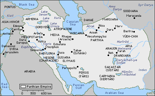
5.1. GENERAL OVERWIEV OF THE ARSACID MILITARY.

Any polity based in the Iranian plateau had to defend a country that stood in an exposed central position, and which can be attacked from almost all sides. Fortunately for the Arsacids and Sasanians, nature had lend them a hand in this in the form of natural barriers, especially in the west and north-west, although these natural barriers left unprotected and exposed to invasion some of the richest territories of the empire (Mesopotamia and Elymais).

Still, the Iranian empires found themselves in the hardly enviable position of having to defend themselves on west and east against empires must vaster and richer in manpower and economic resources than themselves, plus the occasional nomadic invasion from the Caucasus or Central Asia. And then there was the added complication of the quarrels between the magnates about strategic priorities.

This situation, together with the traditions inherited from both the Parni and the ones that already existed in the Iranian plateau and which dated back to Achaemenid times, gave form to the Arsacid military.

The Arsacid and Sasanian armies were cavalry-based armies, with infantry playing a secondary role (although there were sources of good quality infantry in Iran, especially among the mountain tribes), which were essential in order to be assembled and move quickly to the threatened areas, as well as to be shifted from one border to another. Then there was also the manpower question: Iran had small demographic resources, but it needed to mobilize large armies; this was achieved by a thorough militarization of society, centered around the great warlike Parthian clans, capable of rising massive levies among their subjects, as well as by the temporary resource to foreign mercenaries or allies (often they were one and the same).

For the following evaluation of the strength of the Arsacid armies (which would be essentially the same as those available to the early Sasanians), I will follow the article manpower Resources and Army Organization in the Arsakid Empire by Professor Marek Jan Olbrycht from the University of Rzeszów, published in Ancient Society, No.46 (2016).

In the Abstract, Olbrycht states his conclusions: that the total military potential available to the Arsacid kings amounted to about 300,000 soldiers, with the maximum number of soldier available in a single army in any given time amounting to 120,000 – 150,000 men.

Those are huge numbers. For a comparison, the whole Roman army under Augustus is estimated to have amounted to 250,000 men, rising to 360,000-380,000 under Trajan and reaching a peak of 450,000 under Septimius Severus. It’s possible that later in the III century it reached even higher numbers nearing 500,000 men. And all this considering that at its peak, before the Antonine Plague, Belloch estimated the total population of the Roman empire at 61,4 million people (other scholars give somewhat higher estimates, but the usual consensus seems to oscillate between Belloch’s number and 75 million). The comparison (soldiers / inhabitants) between both empires is staggering.

Where does Olbrycht obtain these numbers from? Basically, through two methods: ancient sources and comparison with the (better documented) Achaemenid and Sasanian militaries.

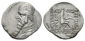
The Roman historian Justin (II c. CE) stated that Frahād IV opposed Mark Antony’s invasion with an army of 50,000 cavalrymen. While the Greek historian Plutarch (II c. CE) when dealing about the same campaign states that a Parthian corps of 40,000 men annihilated Statianus’ supply train while another army totaling at least 40,000 men defended Phraaspa and other strongholds in Atropatene against Mark Antony’s main army. According to Tacitus, Walaxš I offered Vespasian an army of 40,000 men to help him in his fight against Vitellius.

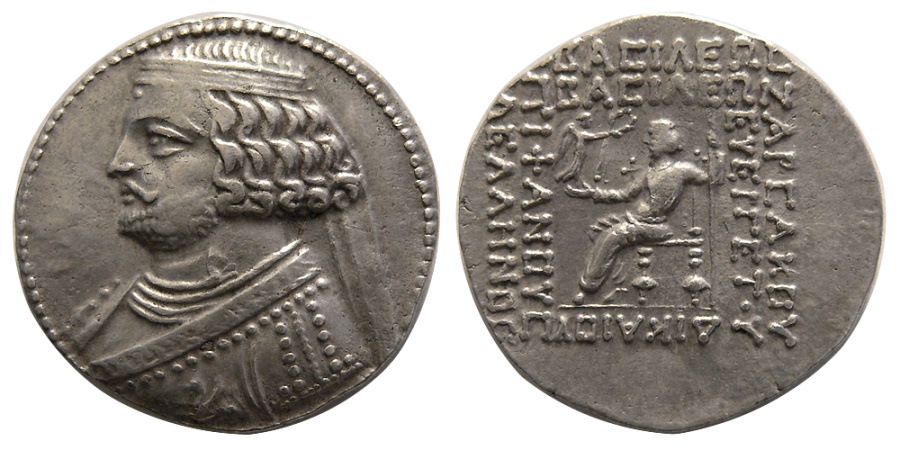
Porphyrios of Tyre (III c. CE) stated that Frahād I (132-127 BC) opposed the invasion of the Seleucid king Antiochos VII Sidetes with and army of 120,000 men. In Sima Qian’s Shiji, we’re informed that when Han envoys reached the eastern Parthian border around 110 BCE, they were escorted to Mihrdad II’s residence at Hekatompylos by a force of 20,000 cavalrymen. In the Syriac Chronicle of Arbela (a not too reliable source, though) it’s again stated that Walaxš IV (192-207 CE) campaigned against his rebellious Medes and Persian subjects with an army of 120,000 men. Thus, several ancient sources seem to agree about the huge numbers of soldiers available to the Arsacid kings.

The most reliable source for the organization of Arsacid armies of this era is the Armenian historian Moses of Khoren (V c. CE), who wrote about the organization of Armenian armies under the reign of Walaxš I of Armenia (51-79 CE); as Armenian armies were fairly identical in organization to Iranian ones, it’s quite safe to assume that the same organization applies to both cases. Arsacid armies were organized following a decimal system, that already existed under the Achaemenids and was kept under the Sasanians. The basic fighting unit was a “battalion” of 1,000 men, organized around a standard in the form of a dragon; drafš in Parthian, which gave its name to the unit. 10 drafš formed a corps, called gund.

If we look at army sizes under the Sasanians, we get that most usual armies oscillated between 20,000 and 40,000 soldiers, but that exceptionally they could be much larger. In 530 CE, two Sasanian armies operated separately in Mesopotamia totaling 80,000 men (according to Procopius). And in 579 CE, Hormozd IV mustered two armies against the Turks in Central Asia amounting to 82,000 men (according to Tabarī). Sebeos gives a number of 80,000 Sasanian soldiers at Qādisiyyah (636 CE), and numbers oscillating between 50,000 and 150,000 are given for the Sasanian army at Nehāvand in 642 CE (the highest number is given by Tabarī).

In light of these numbers, Olbrycht considers that the usual size for an Arsacid royal army (when led by the king in person) must’ve been around 50,000 men.

Olbrycht proposes the following composition for Arsacid armies:
  • A permanent army, formed by the royal guard units, the garrisons in major cities and fortresses and governors’ troops in the provinces.
  • The royal levy, levied from all the lands under direct rule of the Arsacid Šahanšah, including troops from the royal domains and the armies raised by the magnates. Olbrycht calls these forces (the quotation marks are his) a “Parthian national army”, levied amongst the mass of the Iranian population.
  • The armies of the vassal kingdoms (Pārs, Armenia, Adiabene, Hatra, etc.).
  • Mercenaries.
  • Allies, often indistinguishable from mercenaries.
Of these forces, the largest and most important part was the royal levy. The permanent army must have been much smaller. And the difference with the Roman army is striking, because the Romans maintained at all times a massive permanent professional army paid by the state’s treasury. For the permanent royal army, Olbrycht estimates a number of 20,000 men, which compared to Rome’s permanent army is insignificant.

Tacitus’ description of the Arsacid army under Walaxš I mostly agrees with Olbrycht’s structure: a royal guard which was formed mostly by cavalry, auxiliaries from allied or vassal kings, and the royal levy, which Tacitus calls moles. Tacitus and Plutarch also speak of a royal guard for the cases of Frahād IV and Ardawān II. According to Achaemenid precedents and Sasanian later practices, Olbrycht estimates that of the 20,000 men of the permanent army, between 6,000 and 10,000 must have belonged to the royal guard.

As for mercenaries, the Arsacid kings had several sources available to them: Sakas from the east, other nomads from Central Asia, Alans from the Caucasian steppe, and the many mountain peoples within the empire (Cadusians, Daylamites, Mardians, Kyrtians …) or allies (Iberians, Albanians, etc). A practice employed by the Arsacids (and by the Romans) was to recruit into their armies vanquished foes as mercenaries. This is specifically stated for the Greek/Macedonian soldiers of the defeated army of Antiochos VII Sidetes, and Olbrycht raises the possibility that a similar deal was offered to Roman prisoners like the ones taken at Carrhae.

As for the royal levy, it was raised among the āzādān, the “free men” or warrior estate of the Iranian plateau. Of them, those who could afford a horse (magnates and lesser nobles) formed the “equestrian estate” (Parthian asbārān). Freemen who were townsmen or peasants could also be recruited, and the nobility could also take their “serfs” with them.

Military service was compulsive for the nobility and part of the commoners. In particular among the nobility, war training began at a very early age, and carried onto until the boy reached manhood, leading to high standards of military prowess. Olbrycht provides some quotes from Justin, Herodian, Cassius Dio and Ammianus Marcellinus in this respect.

When dealing with the mobilization strengths available to the several parts of the empire, Olbrycht uses the accounts of Polybius, Strabo and Plutarch. Neither of them though gives numbers, so he supports his estimates by drawing a direct comparison with the forces raised from the Achaemenid satrapies, as listed by the Roman historian Quintus Curtius Rufus (I c. CE). The estimates by Olbrycht are as follows:

Lands under direct Arsacid royal rule:
  • Greater Media: 30,000 infantry and 20,000 cavalry.
  • Parthia: 40,000 cavalry and 10,000 infantry.
  • Hyrcania, Areia and Margiana: at least 30,000 men, between infantry and cavalry.
  • Sakastan: “at least” 15,000 cavalrymen.
  • Carmania: 15,000 men, mostly infantry.
  • Susiana (part of Xuzestān, under direct royal rule): 10,000 men, mostly infantry.
  • Babylonia and Mesopotamia (urban militias and Jewish contingents under their own commanders): 10,000 men, almost all of them infantry.
This adds up to 180,000 men, half of whom were cavalry. To it Olbrycht adds the permanent royal army of 20,000 (mostly cavalry), and the forces of Media Atropatene (40,000 infantry and 10,000 cavalry) that from Ardawān II onwards were part of the royal domain. So, Olbrycht reaches a number of 250,000 available soldiers.

When it comes to an estimate of the forces provided by the vassal kingdoms and allies Olbrycht gives the following numbers:
  • Armenia: 46,000 men, 16,000 of whom were cavalry.
  • Elymais: 10,000 infantry.
  • Iberia: 30,000 infantry, 10,000 cavalry.
  • Albania: 30,000 infantry, 10,000 cavalry.
  • (NOTE: Iberia and Albania were allied kingdoms under Arsacid influence, but not vassals)
  • Adiabene: 6,000 cavalry and 4,000 infantry.
  • Pārs: 50,000 men (Olbrycht does not break this number down into cavalry and infantry).
Olbrycht though makes clear that these totals were just available totals, and that the largest number ever mentioned for a single Arsacid army by ancient authors is 120,000, which was also the number quoted by Xenophon in his Cyropaedia for the “Persian army”, and is also given by Arrian in his Anabasis of Alexander.

The royal domains were divided into military provinces, each of which was led by a strategos (Greek term used in several Greek inscriptions across Iran) or marzbān (Parthian word that appears in the texts of Old Nisa). This latter term is also attested during all the Sasanian era.

It’s worth noticing that after Crassus’ defeat at Carrhae (in which he’d invaded with an army of 50,000 men), in all the subsequent Roman full-on assaults against Parthians, the size of their armies increased considerably; 16 legions and 10,000 cavalry for Julius Caesar’s planned expedition, more than 100,000 men for Mark Antony’s expedition, 80,000 men for Trajan’s invasion (according to Bennet’s biography of Trajan), 200,000 men Lucius Verus (according to Yann Le Bohec) and 150,000 for Septimius Severus (according again to Le Bohec).
 
  • 1Like
Reactions:
5.2. WEAPONS AND TACTICS.

It’s clear, judging from ancient sources, that Arsacid armies wee mainly cavalry armies, although they also wielded infantry. Infantry though seems to have been charged mostly with static defensive roles; field armies and especially offensive armies seem to have been entirely formed by cavalry.

According to ancient to ancient sources, this cavalry was divided into lancers and archers. And here we find a somewhat controversial point. At the battle of Carrhae, Surena’s army is described as being formed by 9,000 light cavalry archers and 1,000 heavy cataphracts. This has been usually taken as a rule of thumb for all Arsacid armies, but some scholars disagree, based on ancient texts. One of them is Ilkka Syvänne, from University of Haifa (Note: I’m somewhat sceptic about some of his most “revisionist” assertions in this and other subjects, so I want to make myself clear that here I’m just exposing his conclusions, with which I do not necessarily agree; but he’s a scholar and I’m not). He deals with this subject in an article titled Parthian Cataphract vs. the Roman Army 53 BC-AD 224, published in the magazine Historia I Świat, nr 6 (2017, available for download in pdf format at academia.edu).

Among other ancient sources, he uses Justin and Plutarch's accounts about Mark Antony’s Parthian campaign, where both texts state clearly that Frahād IV’s royal army (50,000 strong) was entirely by cavalrymen that would alternate between fighting at a distance with bow and arrow or charge with the long contus/kontos spear if the occasion arose (if the Romans became disorganized). Syvänne guesses from this that the whole Parthian cavalry could perform both roles, but that given that ancient sources only ever talk about cataphracts engaging the Romans at close quarters, all the cavalrymen were cataphracted.

(There’s an obvious possible second reading of this, different from Syvänne’s: that the Parthian force was a mixed one, and that its parts would alternate in their attacks, but neither Justin nor Plutarch provide enough details.)

Another piece of evidence that could support Syvänne’s reading is the surviving representations of Parthian and early Sasanian cataphracts: they are sometimes shown bearing not only the kontos, but also a quiver with a bow and arrows. In any case, Syvänne supports that the Arsacid kings could have had as many as 50,000 cataphracts (already a dizzying number, given how expensive their equipment was), with the rest of the cavalry being equipped with a lighter gear. He also believes that cataphracts (but not the lighter cavalry) could fight both with bow or spear.

img-36-small480.jpg

(5a and 5b) A couple graffiti of Arsacid / Sasanian cavalrymen from Dura Europus; in these rough sketches both lancers and archers are shown equally armored, both rider and horse.

Tang-e_sarvak_plate_iii.jpg

A rock-carved relief found at Tang-e Sarvak (Islamic Republic of Iran, province of Khuzestan, ancient Elymais), dated between 75 – 200 CE, showing a cataphract bearing both a kontos and a quiver.

1-3.jpg

Drawing of the great rock relief depicting the victory of Ardaxšir I over the last Arsacid king Ardawān V at the battle of Hormozdgan, carved in rock near Firuzabad in Fārs. Both Arsacid and Sasanian riders bear long lances and quivers.

Syvänne describes the basic fighting unit of the Arsacid cavalry a rhomboid of 128 men (with 10 rhomboids forming a drafš). The rhomboid, a formation used by many steppe peoples and which later also adopted by the armies of the Muslim Caliphate, was a formation that allowed it to face attacks from all directions (essential in highly mobile cavalry battles) and would also allow its members to keep shooting when retreating, a favorite Parthian tactic according to ancient texts. In other words, he does no consider the separate employ of archers and lancers by Surena at Carrhae to have been a standard Parthian tactic. As described in Greek military manuals (Asclepiodotus, Aelian and Arrian), this maneuverability was enhanced by carrying leaders on each vertex of the rhombus, which allowed it to turn immediately into any direction without losing its cohesion as a fighting unit.

Ancient authors also state clearly that it was the Parthian’s custom to carry with them droves of replacement horses to the battlefield, so they could change mounts when the horses became exhausted, and according to what happened at Carrhae, in their baggage trains they also carried large reserves of arrows.

Iranian cataphracts would have been properly classified as clibanarii in the Graeco-Roman world, because most surviving representations of them show both horse and rider fully armored. Cataphracts also carried, apart from the long kontos and the quiver, swords, heavy iron maces and pickaxes for close fighting.

According to Graeco-Roman and later Islamic authors the Arsacids and later the Sasanians employed four main variants for the cavalry array:
  • A vanguard of mounted archers (these could be so-called cataphracts that did not wear their entire panoply of equipment when deployed in this manner) behind which was the main force consisting of both mounted archers and cataphracted lancers.
  • A vanguard of mounted archers, behind which stood the cataphracts.
  • A vanguard of mounted archers, behind which stood the mounted archers in the first line and the cataphracts in the second line.
  • A vanguard of mounted archers behind which stood two lines of cataphracts.
In all cases, the mounted archers could consist of cataphracts. Behind the army would stand the baggage train, with the spare horse and the baggage animals loaded with extra spears and arrows. Usually, the commander and its bodyguards stood between the battle array and the baggage train, but he cold also choose to lead from the front (like prince Pakōr did against Ventidius Bassus in 38 BCE, with fatal results).

The Parthians usually employed their cavalry in two different ways. The typical way was to use the advance guard to harass the enemy so that it then feigned flight towards the main force. The main cavalry force consisted typically of cataphracts or of the cataphract center and light cavalry wings if it included subject peoples or allies. The Parthians always sought to encircle the pursuing enemy while their center engaged the enemy in frontal combat. If the enemy could not be defeated through this method, the Parthians tried to wear them down with hit and run tactics with mounted archery which could be employed by both light cavalry and cataphracts.

The Parthians shot with their bows just as well in attack as in retreat (the famous Parthian shot backwards). When the units had exhausted their supplies of arrows or had worn their horses out, they rode back to refill their supplies of arrows or to change their mounts. This meant that during a prolonged major pitched battle the Parthians could deliver huge amounts of arrows on the enemy. This was the way in which the mixed force of light and heavy cavalry under Surena engaged Crassus and the royal Arsacid army engaged Mark Antony. The second way in which the Parthians used their cavalry was to attack the enemy head on immediately as was done by Pakōr in 39-38 BC, but this was an atypical tactic for the Parthians, even if it is listed in later Islamic texts as a tactic employed by ancient Iranians.

The use of hit and run tactics, outflanking and the use of the frightening looking cataphracts with their shiny armor were not the only means the Parthians tried to produce fright in the enemy. They also tried to scare the enemy by means of a deafening cacophony of beaten kettle drums and through the use of surprises, like Plutarch describes vividly in his description of the battle of Carrhae.
 
Last edited:
  • 1Like
Reactions:
Very nice presentation!
 
5.3. THE ARSACID MILITARY. COMPARISON WITH THE ROMAN ARMY.

The first concept that comes to mind when comparing these two ancient militaries is that of asymmetrical warfare.

The Roman army embodied a tradition of infantry-based armies that had prevailed against all the enemies they’d found around the Mediterranean. And that included too cataphracts, that the Romans had met and defeated without much trouble at Magnesia and later in the Armenian campaigns of Lucullus and Pompey.

Thus, when Crassus decided to embark in his ill-fated eastern campaign, nobody had reason to doubt that the Romans would prevail with relative ease once again, as they’d done against all eastern enemies they’d found until then.

But what Crassus’ army found at Carrhae was a completely alien military tradition, a way of warfare that had been born and developed in the Eurasian steppe and that was totally different to the Roman one. The Arsacids had imported it into the Iranian plateau, and had used it with great success for two hundred years against the infantry-based armies of the Seleucids. At Carrhae, Surena knew what to expect, but Crassus and his officers were caught completely by surprise.

This initial surprise though began to wane quickly. During the civil war of the First Triumvirate, Ūrūd II took advantage and overran all the Roman east, including all the Levant and as far away as Lycia and Pisidia. To deal with this, Mark Antony sent one of his generals with a powerful army, Ventidius Bassus, who would be the first Roman general to develop countermeasures against the Arsacid cavalry-based armies, achieving the complete recovery of the Roman East in a brilliant campaign. But still the Romans had difficulties with the “Parthian way of war”, and Mark Antony’s invasion of Media Atropatene ended in a costly defeat and nearly avoided a complete disaster at the hands of Frahād IV’s armies.

The main tactical advantage of Iranian armies lay in the greater tactical and strategic mobility of their cavalry armies. They also enjoyed quantitative and qualitative superiority in cavalry and archery against the Romans. This enabled them to conduct hit and run attacks against Roman armies with total impunity. The only way that the Romans had to force the Arsacid cavalry into close combat (in which Roman legionaries had the advantage) was by either pining the Iranians against a terrain obstacle that obstructed their retreat (like a river or a deep ravine), or by pining the (much superior) Iranian cavalry with their own cavalry for as long as possible (usually a very risky mission) trying to buy time for the legionaries to catch up with them and force the Arsacid horsemen into close combat.

The descriptions of Carrhae, Mark Antony’s Parthian expedition and Corbulo’s Armenian campaigns left to us by ancient authors seem to suggest that whenever the Arsacid cavalry found a solid infantry formation, the Iranian cavalry simply scattered around into loose rhombus formations (or wedge) formations and then proceeded to surround the enemy and shower it with arrows from all directions.

This turned the legionaries into sitting ducks, as their weapons were totally unsuited to return fire against the Parthian bows (which were long composite bows with a much greater range than the bows used by Roman archers: ironically, the only missile weapon that initially worked against Iranian archery were slingers). If the legionaries were battle-hardened veterans, were well disciplined and had confidence in their leaders, they could withstand the attack for a long time (the disaster at Carrhae was mostly due to Crassus’ incompetent leadership and also to the fact that his legions were all formed by “green” recruits), but this situation would slowly erode the morale of even the most warlike soldier in the long way.

At Carrhae, Crassus tried to use his small cavalry detachment of 1,000 Gallic cavalrymen reinforced by a “shock squad” of legionaries on foot (presumably chosen for their fighting abilities and perhaps leaving aside part of their heavy equipment) in order to try to pin down Surena’s mounted archers. This detachment was led by Publius, Crassus’ son. And what happened was that Surenas’s force simply managed to ambush Publius. They retreated in front of Publius’ cavalry while shooting backwards, luring him to follow them. Publius bit the bait and lost contact with the main body, and the “fleeing” Iranian cavalry led him to Surenas’ main cataphract force. Once the Roman detachment was where Surena wanted it, the light cavalry dispersed to the flanks and rear of Publius’ force, enveloping it, while the cataphracts stood immobile in front of him. Probably desperate by this point, Publius charged with his Gallic cavalry against the cataphracts, with predictable consequences. The Iranian heavy cavalrymen were fully armored, men and horse, and were armed with a formidable panoply of long kontos, bow and arrows, sword and mace. While the Gaulish cavalrymen were unarmored and fought only with shield, a short spear and a sword. The cataphracts simply pointed their long, 3,74 meter long kontoi to the breasts of the charging horses and dismounted most of Publius’ cavalry before they even managed to land a single blow (by Arrian’s time in the II century CE, Roman horses in the east wore all chamfrons precisely to avoid this).

This was not the end of Publius’ ordeal though. The surviving Gauls and the legionaries retreated to a nearby hill, while being showered with arrows from all directions; the Iranian horse archers were herding the remnants of the small Roman detachment into a compact group, which would be an ideal target for the cataphracts’ charges. This charge could be formidable. According to Plutarch, the kontos of a charging cataphract was able to transfix the two first legionaries in a file, through shield, armor and flesh.

Perhaps the most remarkable aspect of Plutarch’s account is the complete control that Surena retained at all times over his army. This was not a disorganized “barbarian” force, but a highly disciplined army in which commanders apparently followed Surena’s order very quickly, even quicker than the Romans did. Considering that this was a highly mobile cavalry army that fought widely dispersed over a large area and divided in many small formations, this was an impressive feat.

1437638890043

The plain of Carrhae.

Still at Nisibis (the last battle between Arsacids and Romans, fought in 217 CE), the initial Roman cavalry attack, which was probably meant to try to fix the Arsacid cavalry while Macrinus’ legions advanced, failed miserably because Iranian archers decimated the Roman cavalry (probably by just shooting down their unarmored horses) before they even reached the main Arsacid front line.

Iranian armies did not fight at night (the lack of visibility made their long range archery useless) and did not build fortified encampments. This made them very vulnerable to nocturnal surprise attacks (like the one that Galerius led against the Sasanian šahanšah Narseh in 298 CE). According to ancient authors, they also avoided fighting under rain or in damp weather, because humidity ruined their bows.

The most effective defense of a Roman army in a clash with an Arsacid cavalry army was to form all its infantry in a large hollow square, with the legionaries arrayed in a testudo formation in all directions, with the baggage and camp followers inside. Slingers and archers should be distributed also on all sides, either between the legionaries or immediately behind them, to dissuade the mounted Iranian archers to get too close, and with the available cavalry launching short sallies against the enemy, but returning to the safety of the square if the Iranians retreated, without trying to pursue them.

In these first encounters, all depended on inspired leadership, terrain and numbers (with both sides having considerable reserves at hand on the strategical level).

Over time, the Romans adopted a series of countermeasures against the Arsacids and their tactics, which Syvänne (in same the article I quoted in my previous post) classifies in two great groups, strategical countermeasures and tactical countermeasures.

Strategical countermeasures:
  • The exploitation of one of the endemic civil wars within the Arsacid empire, even provoking or encouraging it if necessary (this proved to be a very successful measure).
  • The use of ruses and stratagems to force the Arsacid defenders to split their forces more thinly along the entire theater (Trajan, Verus, Severus, Caracalla, Severus Alexander, all of them employed this measure).
  • The signing of alliances with the enemies of the Arsacids (the only Arsacid western vassal that never sided with the Romans was Hatra, all the rest changed sides as they saw fit). There are also records of Iranian grandees allying themselves with Rome against their šahanšah, and of diplomatic contacts between Rome and the Kushans.
  • The use of field fortifications in defense to lengthen the campaign, forcing the Arsacid “feudal” armies to outlast their supplies and their willingness to stay away from their homelands (a variation of this measure was used by Macrinus after the battle of Nisibis).
Tactical countermeasures:
  • The use of the hollow square/oblong formation by Roman infantry to negate the mobility advantage of Iranian cavalry.
  • Increasing the numbers of their own auxiliary cavalry (especially units equipped with the long kontos, and from the reign of Hadrian onwards, even units of cataphracts), and also by recruiting more mercenary cavalry and making more use of allied cavalry forces (Osrhoenians, Arabs, Goths, Sarmatians, Alans, Armenians, etc).
  • Changing the equipment and tactics to better counter the Iranian cavalry. Most of these changes seem to have taken place during the II century CE, when Rome fought three large scale and successful wars against the Arsacids. These changes include the introduction of the flat oval shield, which allowed legionaries to fight in tighter formations with overlapping shields (thus increasing the protection) while also allowing the infantrymen to use their pila or spears under the arm or over the shoulder. There was also the introduction of long pikes for the first lines of legionaries, and the recovery of the old Hellenistic model of a 16-ranks depth phalanx, like described in Arrian’s treatise Ektaxis peri Alanon (Deployment against the Alans): the first ranks stood firm and pointed their long pikes against the charging enemy cavalry while the soldiers of the back ranks launched missiles over the heads of their companions against the cavalrymen stopped in front of the pike wall. Probably due to this, pila were progressively abandoned in Rome’s eastern armies in favor of the lighter lancea, which was a light javelin that was easier to hurl over such dense formations, and of which the legionary could carry several units. It’s also possible, but far from proved, that some legionaries received training as bowmen. The short gladius was also replaced by the long spatha, which had a longer reach and was thus more useful against mounted enemies, and which could be used effectively with the oval shield. The Parthian large composite bow was also copied.
  • The use of rough terrain (or land obstacles) whenever possible to negate the mobility advantages of cavalry.
The Romans had never been shy or slow at adapting new weapons and tactics from their foes if they showed themselves effective, and this case was no different from many other previous ones. Already Ventidius Bassus managed to use the “feigned retreat” tactic against an Arsacid force that was blocking the Cilician gates, using his cavalry to lure them into an ambush where his legionaries suddenly attacked them. Still Aurelian would use a similar ruse when fighting against Palmyrene cavalry.

857-c.jpg

The Cilician Gates.
 
Last edited: