

Hey there,
The following maps list a number of oddities that probably need some fixing. The province-density of the upcoming update is really good, so I won't necessarily suggest new provinces, nor will I talk too much about the addition of other tags. This suggestion is really more about geography and the correct naming of cities/provinces. Some of the maps have been posted in other threads, but most of it is new. The descriptions are quite important, as some of them explain certain drawings I made (so, for context). As always, the red dots indicate proper city-locations.
Without further addo:
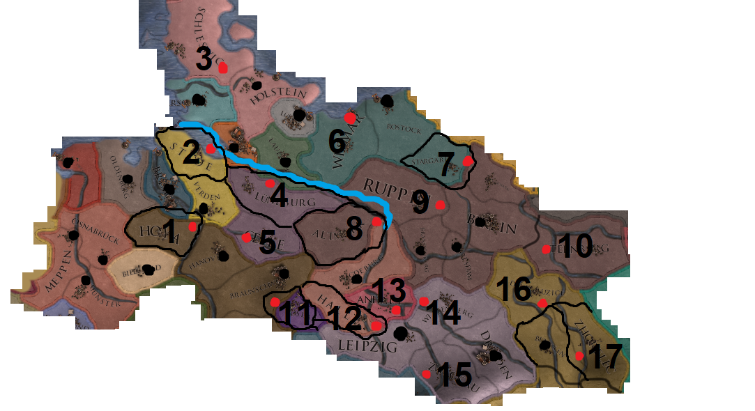
1: Hoya's location should be moved and its borders slightly tweaked.
2: The Elbe-estuary is quite broad, broader than it should be. It seems as if the sea starts at Hamburg, which isn't the case. A minor thing, but still.
3: Schleswig was a part of the HRE, that's why I counted it for this region. Its city-location is way off.
4: Lüneburg should be closer to the river and its borders slightly tweaked.
5: Celle should be beneath the Aller-river and more to the west.
6: Wismar is a coastal city.
7: Neubrandenburg (as I've noticed you guys changed the name from Stargard, which is a very welcome change) should be on the border of the province, so a slight tweak might be necessary.
8: Altmark's borders should be changed so that its capital, Stendal, can be tweaked.
9: Ruppin should be moved slightly.
10: Sternberg's current capital is its namesake; Sternberg. This was a very small administrative village during most of EU4's timeframe, an actual city of economic and bureaucratic importance was Frankfurt an der Oder. I suggest changing the capital to this town. The province-name itself is fine; as Sternberg was a county.
11: Goslar's location isn't within the province itself.
12: Halle should be on the other side of the river.
13: Dessau should be moved to the river-junction. This is not of huge importance.
14: Wittenberg should be at the border; it was quite close to Dessau.
15: Zwickau should be moved to the other side of the river. Its borders should preferably
16: Cottbus should be more to the south.
17: Görlitz should be on the other side of the river.
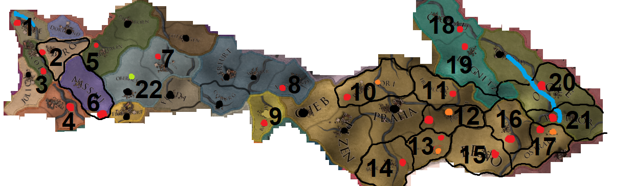
1: Kleves/Kleef should be closer to the Dutch border and more to the north-west.
2: Düsseldorf should be at the river, this might mean that the province needs a slight border-fix.
3: Köln should be moved to the south, beneath Düsseldorf.
4: Koblenz should be between the two rivers.
5: Arnsberg should be slightly moved, this is of minor importance, though.
6: I've noticed that Nassau's capital (Wiesbaden) has already been placed around the border to the south in recent developer-diaries, but it should be even further south; (almost) at the river. This means a slight border tweak which will make the Mainz-province slightly smaller in the north.
7: Slight tweak to Kessel's location. Is of minor importance, though.
8: Slightly tweaked Plauen's location.
9: Slightly tweaked Bayreuth's location.
10: Litomerice, the orange dot, shouldn't be the capital of this province. Zatec (red dot) should be it; it was far more important during most of EU4. This also means that the province-name needs to change (to Zatecko).
11: Minor tweak, but Hradec Králové should be at the river.
12: Pardubice (orange dot) wasn't all that important during most of EU4, it only rose up during the industrial age. I suggest changing the province name to Caslavsko and city-name to Kutná Horá (red dot). While Kutná Horá wasn't the provincial capital of this administrative entity (Caslav was), Kutná Horá was much more important. Prague wasn't a capital of an administrative unit, either. If this is not acceptable, then I suggest naming both the city and the province Kutná Horá. Either way, Pardubice is quite wrong for EU4. It was basically a small village.
13: I'd suggest changing the province-name to Jihlava (red dot) or deleting the province altogether, as it would be quite small. Jindrichuv Hradec (orange dot) was like Ostrava and Pardubice; small and not noteworthy enough until the end of the 18th century.
14: Budejovice should be around the other side of the river.
15: Slightly tweaked Brno's location; this is of very, very minor importance though.
16: Slightly tweaked Olmütz's location.
17: Opava (red dot) should be the province-name, not Ostrava (orange dot). Ostrava only grew during the industrial age.
18: Moved Glogau's location to the east.
19: Slightly moved Liegnitz's location, quite minor, though.
20: Moved Opole a bit, as well as the river (the blue line is just a draft, but the river is quite flawed).
21: Ratibor should be moved quite a bit and be on the other side of the river.
22: The current capital of the province is Marburg, but Marburg is located at the green dot. The black dot actually indicates Gießen, which is also a good option. I would personally keep Marburg and move the city to the green dot.
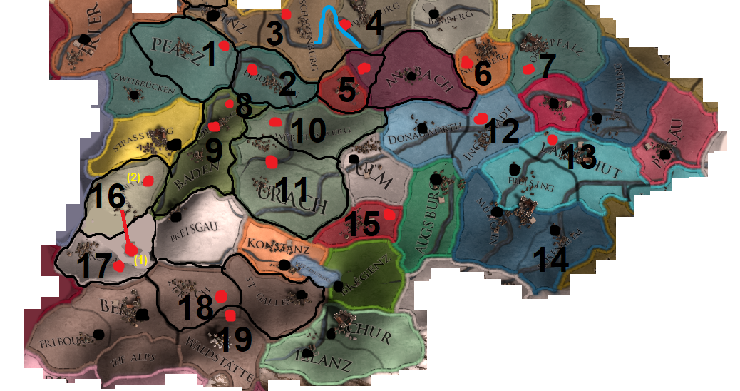
1: The town of Worms should be moved to the river.
2: The town of Heidelberg should be much closer to the riverjunction.
3: Aschaffenburg's city should be moved to the north-west.
4: Minor change to Wurzburg and the river there.
5: Rothenburg should be moved and its border extended. EDIT: This has been fixed.
6: Nürnberg should be moved a little to the south-west.
7: Amberg should be moved alittle to the south.
8 and 9: Baden is actually located in the new Durlach province (around contemporary Karlsruhe). Fixing the borders and city-locations would result in such a small Durlach-province that I'd just merge the two like before: Baden with the capital of Baden.
10: Stuttgart should be moved a little, not sure if this was done already, but I did see that the province-name was changed from Wurttemberg to Stuttgart, which is good.
11: Reutlingen should be moved to the river, thus needing a border-change for the Urach-province. Also, I think the Urach-province should be renamed to Reutlingen, as Reutlingen wasn't a part of the Uracher Teil. 'We can also make Urach the capital!' Nope, Urach only had 1800 or so inhabitants in the 15th century, while Reutlingen had around 5000. Reutlingen should still be the capital, in my opinion. But also the province-name.
12: Ingolstadt should be above the river. EDIT: This has been fixed, thanks!
13: Landshuit should be above the river.
14: Already has been fixed! It's now called Wasserburg and under control of the correct Bavarian duchy.
1̶5̶:̶ ̶M̶e̶m̶m̶i̶n̶g̶e̶n̶ ̶s̶h̶o̶u̶l̶d̶ ̶b̶e̶ ̶m̶o̶v̶e̶d̶.̶ (edit: after a quick check, this one seems to be quite fine)
16: Mülhausen (1) is not within the province, but located in the Sundgau-province. Changing the borders doesn't need to happen, though. Why not? Well, Mülhausen was one of the smaller cities comprising the Dekapolis; it had around 1800 inhabitants during the 15th century and joined the Swiss Confederacy later on. A good alternative would be (2): Schletstadt; it had 5000 to 6000 inhabitants and it was also the place where the meetings between the members of the Dekapolis were held. So, I suggest renaming the province as well as the city to Schletstadt.
17: Altkirch isn't located to the west, but to the east. Its borders should be adjusted to make them more historical.
18: Zürich should be moved a little.
19: Schwyz's location should be moved to the north and its borders slightly adjusted.
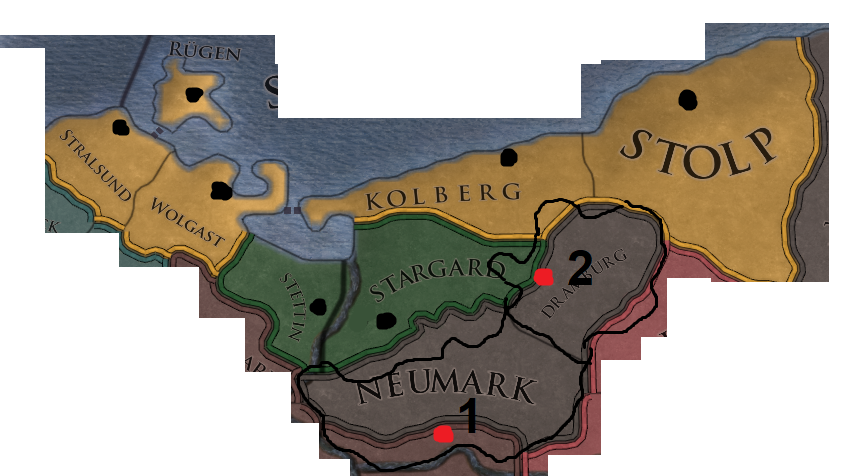
We haven't seen the cities on the map yet for the new Pomeranian setup, so the black dots indicate the rough location of where the towns should be. Stolp was a bit harder to place, but it needs to be very close to that dot if I haven't placed it correctly. The Neumark still has some flaws, though.
1: Landsberg should be really close to the river there. Seeing as Dramburg was a part of the Neumark as well, I don't think Neumark, as province-name, is still necessary. Landsberg would be better. The area of Neumark is simply bigger than just the province. The border-changes would also make Stargard a bit bulkier, which is historically correct.
2: Dramburg should be moved a bit and its borders adjusted.
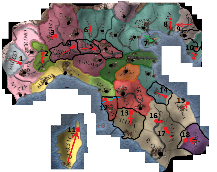
1: Moved the town/stronghold of Saluzzo to its correct location (might not be possible because of the mountains, but still listed).
2: The town of Montferrat (Casale Monferrato) should be moved to its correct location.
3: Very minor, but Novara could be moved a bit, isn't really that necessary though.
4: Pavia is not the same as Alessandria. It should be moved it to its correct location, but that's currently in the Cremona-province. Provinces need a different shape to accomodate this change.
5: Cremona is actually located in the Mantova-province, so it should be moved. Both provinces need to get an overhaul in terms of shape.
6: Slightly moved Bergamo, might not be possible because of the mountains, though.
7: Venice has been fixed in the latest ddiaries, its shape as well. Thank you!
8: Udine (capital of Friuli) was far more inland, it should be moved to its correct location.
9: Görz/Gorizia is way off; will mention this in more detail in the Austria-section.
10: I guess Pula/Pola is the new capital for Istria; so I moved it to its correct location. Triëst should also have a very different shape, but I will go into more detail about this in the Austria-section.
11: The current capital of Bastia (Corsica) is way off, on the other side of the island, even.
12: Pisa is not located within its province. The river should be changed a little, as it runs to the south of Pisa. Quite a necessary fix; I don't think it's acceptable to have cities in whole different provinces.
13: Siena wasn't a coastal town, but far more inland. This really needs fixing.
14: Urbino (the town) could use a slight relocation, it was kind of hard to pinpoint its location exactly, but it should be slightly beneath Firenze and more to the east.
15: Ancona was a coastal town; it definitely needs to move. The only province left in Italy that could really use a split, though. But alas.
16: Perugia needs to be placed on the other side of the river, then it's also on the correct side of Rome. There being a Perugia-tag now as a vassal for the Papal States is also a very welcome change and slightly makes up for the decision to make Bologna independent.
17: Spoleto is way off; it's barely within its own province. I suggest taking a small piece from Perugia, just in case.
18: The capital of Abruzzi (L'Aquila) is in the correct location in the current version of EU4, but this map-update places it way too far to the east. A small bit of Spoleto should be chipped away for a more aesthetically/historically pleasing Abruzzi and the capital moved to the correct location. The name of L'Aquila should also be Aquila, as L'Aquila came into existence because of Mussolini and thus is anachronistic.
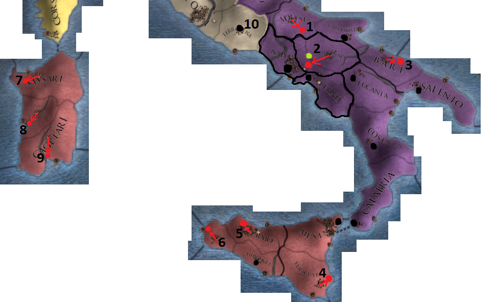
1: Campobasso (the presumed capital for Molise) should be moved a little bit.
2: The new province of Avellino is like the Lleida of this new Italy-update; the town is not within the confines of the province. The green dot indicates the location of Benevento, but I understand why it wasn't chosen. The borders of this province need to change, though, if Avellino is to be fully included.
3: Bari's a coastal town and should be more to the east.
4: Slightly moved the city of Syracuse, minor change.
5: Slightly moved the city of Palermo, minor change.
6: Trapani is a coastal town and more to the north than shownn at the moment.
7: Moved Sassari to its correct location near the coast.
8: Oristano (the presumed capital for Arborea) is located in the wrong location, I moved its position more to the coast.
9: Cagliari is a coastal town, so moved it to its correct position.
10: Terracina is a wrong name for the province. The province seems to represent Campagna et Marittima, a province of the Papal states. With the capital of Ferentino and then Frosinone, the latter which seems to be the capital for the EU4-province (although they're geographically very close to each other). I suggest changing the name of the province to Campagna. Terracina itself was just a small fishing village on the coast and presumably not even the capital.
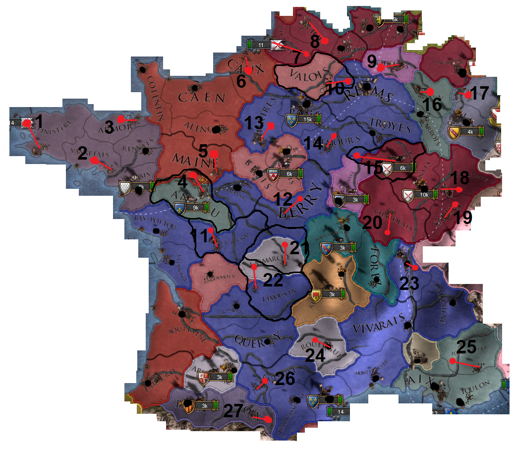
1: Its capital is currently Brest, but it's roughly in the location of Quimper. It can go either way; or change the capital- and province-name to Quimper or change the capital- and province-name to Brest and move it to the correct location. Finistere is anachronistic in any case.
2: Vannes should be moved to the correct location.
3: Armor is an anachronistic name, the capital is currently Saint-Malo; this name fits for the province, as well. The location of Saint-Malo (the town) needs to be adjusted, too.
4: The capital (Angers, which is in the Maine-province) should be moved to the correct bank of the river, as the current capital is in the location of Saumur. A different city altogether.
5: The capital of Le Mans should be moved more to the north.
6: The city of Rouen should be moved and the province should be renamed to Rouen, as well. The Pays de Caux was a geographical entity excluding a big part of the Caux-province and Rouen.
7: The capital should be moved way inland; Amiens is not coastal by any means.
8: The capital, Arras, should be way to the south-east.
9: The capital, Rethel, should be on the correct bank of the river.
10: Soisson should be in the correct position above the river and in the current Reims-province. The current capital is in the position of Compiegne, not Soissons.
11: The city of Poitiers should be moved more to the north, preferably cutting a small bit from Anjou.
12: Bourges should be moved quite a bit.
13: The capital of Chartres should be a little bit more to the north-east.
14: Nemours' city should be moved to the riverjunction.
15: Auxerrois currently has the fortress of Semur as capital, but it should have Auxerre as capital; the city it was named after in the first place and far more important (as well as its capital). This means some borders have to be adjusted.
16: Verdun should be to the east of Bar-le-Duc, this might also mean that the river has to be adjusted to make this possible, as Verdun was still on the west bank of the river.
17: Metz should be on the side of the river, the province should also be renamed from Trois-Evechés to just Metz, as two out of the three 'Evechés' (bishoprics), Verdun being one of them, weren't even located within the province.
18: Besancon should be moved a little to the east. Seeing as Franche-Comté has been split, this also means that the province-name needs a change, as Salins is just as much Franche-Comté as Besancon. I'd suggest to change it to the capital.
19: Salins should be quite a bit further to the north.
20: Charolais' capital, Charolles, should be way to the south.
21: Gueret, La Marche's capital, should be moved and the province reshaped; its general location is just off. Like Limoges.
22: The capital of Limoges should be above that river and the province reshaped, as mentioned above.
23: Lyon should be on the correct bank of the river, at the junction.
24: Rodez should be more to the west.
25: Forcalquier needs to move quite a bit; it's still in the position of Draguignan.
26: Moved the capital of Toulouse to the correct bank of the river.
27: Moved the capital of Foix to the bank of the river.
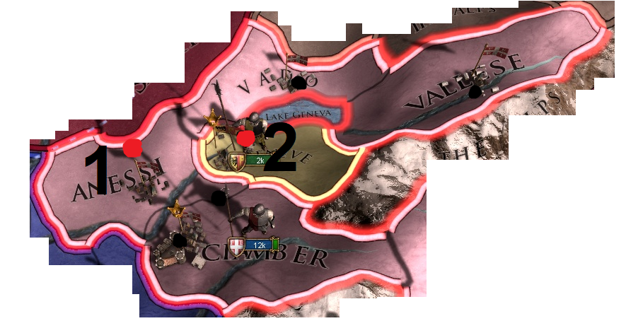
1: It seems Anessi is called Bresse now, which is good. The capital (which is presumably Bourg-en-Bresse then) should be moved to the red dot, thoug, as it's currently in the position of Belley.
2: Geneva is quite fine at the moment, I guess it borders the lake somewhat. Minor detail.
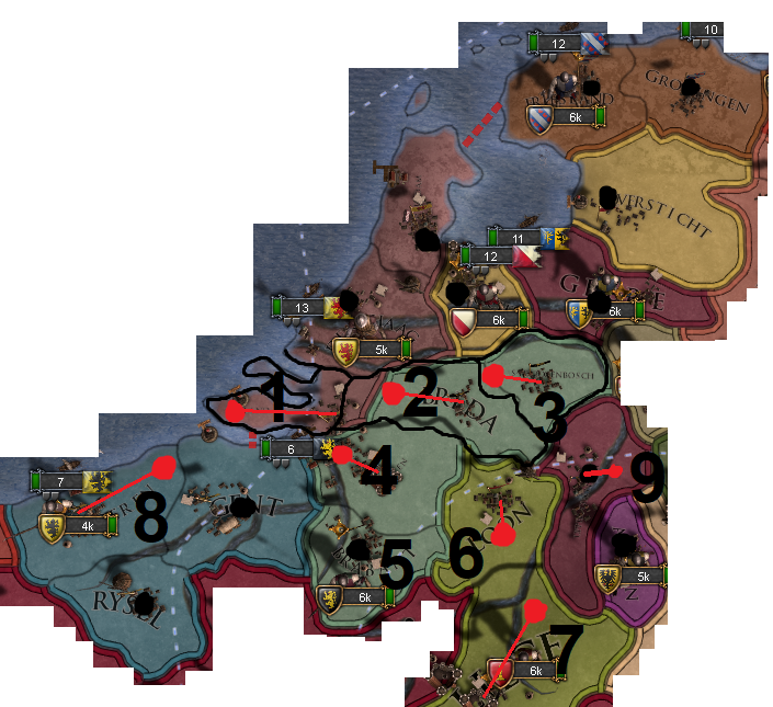
1: Zeeland's capital, Middelburg, should be moved and the province itself should honestly be a couple of islands (like Naxos) with the mainland part (county of Bergen op Zoom) being given to Breda, like it was in history.
2: The capital of Breda should be moved to its correct location on the border between Breda and Zeeland. So, some border-adjustments need to be made.
3: 's Hertogenbosch's city should be moved to the correct location within the province of Breda and its borders adjusted.
4: Antwerpen should be closer to the mouth of the river Schelde.
5: Brabant should be renamed to Brussel, as Breda, 's Hertogenbosch, Antwerpen and Brussels were all part of the entity called Brabant.
6: Loon's capital should be slightly moved and it should be renamed to Hasselt; its economic capital.
7: The capital of Luik/Liege should be moved to the correct position at the riverjunction.
8: The capital of Vlaanderen (Brugge) should be moved and the province should be renamed to Brugge, as Vlaanderen was bigger than just that province and also included Gent and Rysel.
9: Roermond should be moved to the correct location on the river Maas.
1: Silistre(Tur.)/Silistra(Bul.) should be moved, the borders have to be adjusted as well. The current location of the town is in the location of Constanta (which luckily didn't get added as a separate province).
2: Kirkkilise isn't located there, but in the Edirne province. Burgas is seemingly still the capital, which is wrong. If you guys don't mind a Byzantine-province, call it Mesembria and give it #1 as capital (Nesebar/Mesembria) or call it Sozopol and give it #2 as capital, no border-changes needed. If you guys want it to stay Ottoman, then move the capital to either #3 (Islimiye, border-changes needed to the west) or to #4 (Varna, border-changes needed to the north). I'd personally go for Varna. But, again, the province needs to be edited as it's very flawed.
3: Filibe/Plovdiv should be moved a bit and be beneath the river. It's roughly above the island of Thasos.
4: Sofya should be a bit more to the south-east.
5: Trikala/Tirhala should be the capital of its namesake province; It wasn't a coastal town.
6: Glarentza is currently the capital, but in the wrong location. Funfact: It doesn't exist anymore nowadays.
7: Mystras should be the capital of Morea, not Nafplio. The latter was a Venetian city. Also, both Achaea and Morea could use a namechange, as Achaea and Morea refer to the same peninsula.
8: Vidin should be at a different riverbend. Also; riverbends are kind of wonky, but that's minor at best. The city-location of Vidin is a bigger issue in this case.
9 and 10: Kostendil should be Köstendil and Gumulcine should be Gümülcine.
I've spoken quite a bit with @otaats and we both worked on some Balkan-suggestions, some of his work is shown in this suggestion and other parts (especially city-locations) are things I looked up myself. I hope this is a satisfying list of feedback for your region, my friend!
1: Zadar is a coastal city; it should be moved a little. A very minor issue, though.
2: Bosnia/Bosna refers to the river that flows through some of the Bosnian provinces, there are better alternatives. The best one is calling the province Usora. CK2 did the same thing, as well. Doboj, the capital, is in roughly in the middle of the historical region of Usora.
3: Visoki was the name of the fortress that quickly got abandoned a few decades after EU4's beginning, the town beneath was called Visoko and stayed important, also during Ottoman rule. I suggest changing the province-name to Visoko, instead of Visoki.
4: The capital of the 'Herceg' and of Hercegovina ('Land of the Herceg (=duke)') was located at the coast; Herceg Novi (the red dot). Also, it's Hercegovina in Serbian, not Herzegovina. So, the province-name needs a small adjustment as well. The port was quite important and even the Spanish controlled it for a little while.
5: The fortress of Bács should be moved close to the river. This part of the Hungarian kingdom had a lot of Serbian influences, that's why I encompassed it within this suggestion.
6: Mitrovica should be more to the west.
7: Smederevo should be the capital of Serbia; Brankovic just moved in here.
8: Branicevo's capital (Krusevac) isn't located in the current province. Its borders and city-location need to be adjusted.
9: All three of Zeta's capital-choices are (nearly) outside the province. Its current capital is Zabljak, not the big modern city to the north of Montenegro, but Zabljak Crnojevica, a fortress-town. This was fortress was only the capital until 1482, though. #2 indicates the correct location of this town. The bishopric of Cetinje (#1) became the capital of the Prince-Bishopric of Montenegro after the Ottomans had conquered parts of Zeta, they were a thorn in the sides of the Ottomans and de-facto independent most of the times. Zabljak was under steady Ottoman control, that's why Cetinje might be a better alternative. The last option is #3 Podgorica, the most important city and the capital nowadays, but probably a bit too contemporary for the game. This makes Cetinje a really good candidate. It doesn't matter which option is chosen, the borders need to change.
10: Krujë is currently located within the Durazzo province, its borders to the north and the location of its capital need to be adjusted.
11: I hope Srebrenica is the capital of the new Podrinje-province, it was economically very important and regularly changed hands before and a little while after EU4's start because of its silver-mines. The location of the town on the map is already correct, as well. Visegrad could also be its capital, but it should be moved to the south then.
1: If possible, the capital of Meran needs to move a little bit as it was to the east of Innsbruck.
2: Lienz should be closer to the border and the river Drau should be reworked quite a bit. The blue line is just a concept, of course.
3: Salzburg should be more to the south, as it's currently at the same level as Munich.
4: Braunau am Inn should be at the riverjunction and roughly to the north of Salzburg.
5: Oberkärnten's capital (Villach) is way off, the province-borders need to be adjusted and the river Drau (as mentioned earlier) reworked so that it runs to the north of Villach instead of the south. The Drau should also run beneath Klagenfurt instead of above it.
6: As mentioned earlier in the Italy-part; Görz is way off. It wasn't that far inland nor was it coastal, as the current version seems to imply. The province-borders need to look a bit more like the ones in the current version, though. Also, the Soca river needs some changes; it should at least be to the west of Görz.
7: Laibach needs to be more to the south. The Sava river needs to edited, too, and run above Laibach.
8: Graz should be more to the south. Its borders with Celje, Varazdin and Sopron need to be changes, as well.
9: Celje is located too far north, its borders need to be adjusted and the rivers running through it, as well.
10: Triëst's province-shape doesn't cover the Habsburg territories to the south, at all. It needs to merge with the new Rijeka province or there should be two Free-City-sized provinces in that location. Both under Habsburg control, as Rijeka was held by the Lords of Walsee (Habsburg vassals), which had acquired it from the Frankopan's of Croatia a hundred years or so earlier. Direct control by the Habsburgs happened when it was bought from the Lords of Walsee around 1466.
 Also, Triëst should be reachable though Krain, as both parts were only seperated from each other by a small strip of Gorizian land. The Kleinstaaterei-thread gives a good indication on how to draw the borders in and around Istria correctly: https://forum.paradoxplaza.com/foru...staaterei-the-great-hre-map-revision.1156003/
11: Oberenns, which is a correct name, by the way, also covered the new Traungau province. I suggest renaming it to Linz, the capital.
12: Ostmark was a name used by the nazis for a new administrative region of Austria after the Anschluss had happened. The Ostmark was actually a combination of both Viertel ob dem Manhartsberg and Viertel unter dem Manhartsberg (two administrative entities from the era which EU4 covers, named after mountains). I suggest changing the province-name to either Manhartsberg or to its capital; Krems. Manhartsberg has my preference.
13: Graz was the capital of the Steiermark, having Steiermark as its own province is still kind of odd because of that. I suggest changing the name to Judenburg; its capital.
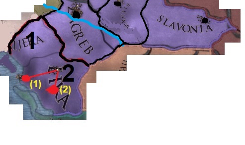
1: As mentioned in the Austria-part; Rijeka either needs to be a mini-province (a bit of the white part shown on the map here above, under Habsburg control) or be merged with Lika. Either way, the island of Krk should be Croatian.
2: Lika should have either Senj (#1) or Gospic (#2) as capital.
@Caligula Caesar Please take a very good look at this; I hope you guys are able to work with it.
The following maps list a number of oddities that probably need some fixing. The province-density of the upcoming update is really good, so I won't necessarily suggest new provinces, nor will I talk too much about the addition of other tags. This suggestion is really more about geography and the correct naming of cities/provinces. Some of the maps have been posted in other threads, but most of it is new. The descriptions are quite important, as some of them explain certain drawings I made (so, for context). As always, the red dots indicate proper city-locations.
Without further addo:
1: Hoya's location should be moved and its borders slightly tweaked.
2: The Elbe-estuary is quite broad, broader than it should be. It seems as if the sea starts at Hamburg, which isn't the case. A minor thing, but still.
3: Schleswig was a part of the HRE, that's why I counted it for this region. Its city-location is way off.
4: Lüneburg should be closer to the river and its borders slightly tweaked.
5: Celle should be beneath the Aller-river and more to the west.
6: Wismar is a coastal city.
7: Neubrandenburg (as I've noticed you guys changed the name from Stargard, which is a very welcome change) should be on the border of the province, so a slight tweak might be necessary.
8: Altmark's borders should be changed so that its capital, Stendal, can be tweaked.
9: Ruppin should be moved slightly.
10: Sternberg's current capital is its namesake; Sternberg. This was a very small administrative village during most of EU4's timeframe, an actual city of economic and bureaucratic importance was Frankfurt an der Oder. I suggest changing the capital to this town. The province-name itself is fine; as Sternberg was a county.
11: Goslar's location isn't within the province itself.
12: Halle should be on the other side of the river.
13: Dessau should be moved to the river-junction. This is not of huge importance.
14: Wittenberg should be at the border; it was quite close to Dessau.
15: Zwickau should be moved to the other side of the river. Its borders should preferably
16: Cottbus should be more to the south.
17: Görlitz should be on the other side of the river.
1: Kleves/Kleef should be closer to the Dutch border and more to the north-west.
2: Düsseldorf should be at the river, this might mean that the province needs a slight border-fix.
3: Köln should be moved to the south, beneath Düsseldorf.
4: Koblenz should be between the two rivers.
5: Arnsberg should be slightly moved, this is of minor importance, though.
6: I've noticed that Nassau's capital (Wiesbaden) has already been placed around the border to the south in recent developer-diaries, but it should be even further south; (almost) at the river. This means a slight border tweak which will make the Mainz-province slightly smaller in the north.
7: Slight tweak to Kessel's location. Is of minor importance, though.
8: Slightly tweaked Plauen's location.
9: Slightly tweaked Bayreuth's location.
Disclaimer: Bohemia's map (and that of Silesia as well) is quite distorted because of the rivers and the borders, which aren't very correct. For example, parts of Hungary and Austria should actuall be parts of southern Bohemia. This results in the locations being a bit close to each other, which is understandable and I won't touch upon this in this thread. The Kleinstaaterei-thread actually uses correct locations for Bohemia. https://forum.paradoxplaza.com/foru...staaterei-the-great-hre-map-revision.1156003/ The new provinces added in Bohemia aren't proper historical options, as well. I will discuss this here below and the thread linked here above talks about it, as well.
11: Minor tweak, but Hradec Králové should be at the river.
12: Pardubice (orange dot) wasn't all that important during most of EU4, it only rose up during the industrial age. I suggest changing the province name to Caslavsko and city-name to Kutná Horá (red dot). While Kutná Horá wasn't the provincial capital of this administrative entity (Caslav was), Kutná Horá was much more important. Prague wasn't a capital of an administrative unit, either. If this is not acceptable, then I suggest naming both the city and the province Kutná Horá. Either way, Pardubice is quite wrong for EU4. It was basically a small village.
13: I'd suggest changing the province-name to Jihlava (red dot) or deleting the province altogether, as it would be quite small. Jindrichuv Hradec (orange dot) was like Ostrava and Pardubice; small and not noteworthy enough until the end of the 18th century.
14: Budejovice should be around the other side of the river.
15: Slightly tweaked Brno's location; this is of very, very minor importance though.
16: Slightly tweaked Olmütz's location.
17: Opava (red dot) should be the province-name, not Ostrava (orange dot). Ostrava only grew during the industrial age.
18: Moved Glogau's location to the east.
19: Slightly moved Liegnitz's location, quite minor, though.
20: Moved Opole a bit, as well as the river (the blue line is just a draft, but the river is quite flawed).
21: Ratibor should be moved quite a bit and be on the other side of the river.
22: The current capital of the province is Marburg, but Marburg is located at the green dot. The black dot actually indicates Gießen, which is also a good option. I would personally keep Marburg and move the city to the green dot.
1: The town of Worms should be moved to the river.
2: The town of Heidelberg should be much closer to the riverjunction.
3: Aschaffenburg's city should be moved to the north-west.
4: Minor change to Wurzburg and the river there.
5: Rothenburg should be moved and its border extended. EDIT: This has been fixed.
6: Nürnberg should be moved a little to the south-west.
7: Amberg should be moved alittle to the south.
8 and 9: Baden is actually located in the new Durlach province (around contemporary Karlsruhe). Fixing the borders and city-locations would result in such a small Durlach-province that I'd just merge the two like before: Baden with the capital of Baden.
10: Stuttgart should be moved a little, not sure if this was done already, but I did see that the province-name was changed from Wurttemberg to Stuttgart, which is good.
11: Reutlingen should be moved to the river, thus needing a border-change for the Urach-province. Also, I think the Urach-province should be renamed to Reutlingen, as Reutlingen wasn't a part of the Uracher Teil. 'We can also make Urach the capital!' Nope, Urach only had 1800 or so inhabitants in the 15th century, while Reutlingen had around 5000. Reutlingen should still be the capital, in my opinion. But also the province-name.
12: Ingolstadt should be above the river. EDIT: This has been fixed, thanks!
13: Landshuit should be above the river.
14: Already has been fixed! It's now called Wasserburg and under control of the correct Bavarian duchy.
1̶5̶:̶ ̶M̶e̶m̶m̶i̶n̶g̶e̶n̶ ̶s̶h̶o̶u̶l̶d̶ ̶b̶e̶ ̶m̶o̶v̶e̶d̶.̶ (edit: after a quick check, this one seems to be quite fine)
16: Mülhausen (1) is not within the province, but located in the Sundgau-province. Changing the borders doesn't need to happen, though. Why not? Well, Mülhausen was one of the smaller cities comprising the Dekapolis; it had around 1800 inhabitants during the 15th century and joined the Swiss Confederacy later on. A good alternative would be (2): Schletstadt; it had 5000 to 6000 inhabitants and it was also the place where the meetings between the members of the Dekapolis were held. So, I suggest renaming the province as well as the city to Schletstadt.
17: Altkirch isn't located to the west, but to the east. Its borders should be adjusted to make them more historical.
18: Zürich should be moved a little.
19: Schwyz's location should be moved to the north and its borders slightly adjusted.
We haven't seen the cities on the map yet for the new Pomeranian setup, so the black dots indicate the rough location of where the towns should be. Stolp was a bit harder to place, but it needs to be very close to that dot if I haven't placed it correctly. The Neumark still has some flaws, though.
1: Landsberg should be really close to the river there. Seeing as Dramburg was a part of the Neumark as well, I don't think Neumark, as province-name, is still necessary. Landsberg would be better. The area of Neumark is simply bigger than just the province. The border-changes would also make Stargard a bit bulkier, which is historically correct.
2: Dramburg should be moved a bit and its borders adjusted.
1: Moved the town/stronghold of Saluzzo to its correct location (might not be possible because of the mountains, but still listed).
2: The town of Montferrat (Casale Monferrato) should be moved to its correct location.
3: Very minor, but Novara could be moved a bit, isn't really that necessary though.
4: Pavia is not the same as Alessandria. It should be moved it to its correct location, but that's currently in the Cremona-province. Provinces need a different shape to accomodate this change.
5: Cremona is actually located in the Mantova-province, so it should be moved. Both provinces need to get an overhaul in terms of shape.
6: Slightly moved Bergamo, might not be possible because of the mountains, though.
7: Venice has been fixed in the latest ddiaries, its shape as well. Thank you!
8: Udine (capital of Friuli) was far more inland, it should be moved to its correct location.
9: Görz/Gorizia is way off; will mention this in more detail in the Austria-section.
10: I guess Pula/Pola is the new capital for Istria; so I moved it to its correct location. Triëst should also have a very different shape, but I will go into more detail about this in the Austria-section.
11: The current capital of Bastia (Corsica) is way off, on the other side of the island, even.
12: Pisa is not located within its province. The river should be changed a little, as it runs to the south of Pisa. Quite a necessary fix; I don't think it's acceptable to have cities in whole different provinces.
13: Siena wasn't a coastal town, but far more inland. This really needs fixing.
14: Urbino (the town) could use a slight relocation, it was kind of hard to pinpoint its location exactly, but it should be slightly beneath Firenze and more to the east.
15: Ancona was a coastal town; it definitely needs to move. The only province left in Italy that could really use a split, though. But alas.
16: Perugia needs to be placed on the other side of the river, then it's also on the correct side of Rome. There being a Perugia-tag now as a vassal for the Papal States is also a very welcome change and slightly makes up for the decision to make Bologna independent.
17: Spoleto is way off; it's barely within its own province. I suggest taking a small piece from Perugia, just in case.
18: The capital of Abruzzi (L'Aquila) is in the correct location in the current version of EU4, but this map-update places it way too far to the east. A small bit of Spoleto should be chipped away for a more aesthetically/historically pleasing Abruzzi and the capital moved to the correct location. The name of L'Aquila should also be Aquila, as L'Aquila came into existence because of Mussolini and thus is anachronistic.
1: Campobasso (the presumed capital for Molise) should be moved a little bit.
2: The new province of Avellino is like the Lleida of this new Italy-update; the town is not within the confines of the province. The green dot indicates the location of Benevento, but I understand why it wasn't chosen. The borders of this province need to change, though, if Avellino is to be fully included.
3: Bari's a coastal town and should be more to the east.
4: Slightly moved the city of Syracuse, minor change.
5: Slightly moved the city of Palermo, minor change.
6: Trapani is a coastal town and more to the north than shownn at the moment.
7: Moved Sassari to its correct location near the coast.
8: Oristano (the presumed capital for Arborea) is located in the wrong location, I moved its position more to the coast.
9: Cagliari is a coastal town, so moved it to its correct position.
10: Terracina is a wrong name for the province. The province seems to represent Campagna et Marittima, a province of the Papal states. With the capital of Ferentino and then Frosinone, the latter which seems to be the capital for the EU4-province (although they're geographically very close to each other). I suggest changing the name of the province to Campagna. Terracina itself was just a small fishing village on the coast and presumably not even the capital.
1: Its capital is currently Brest, but it's roughly in the location of Quimper. It can go either way; or change the capital- and province-name to Quimper or change the capital- and province-name to Brest and move it to the correct location. Finistere is anachronistic in any case.
2: Vannes should be moved to the correct location.
3: Armor is an anachronistic name, the capital is currently Saint-Malo; this name fits for the province, as well. The location of Saint-Malo (the town) needs to be adjusted, too.
4: The capital (Angers, which is in the Maine-province) should be moved to the correct bank of the river, as the current capital is in the location of Saumur. A different city altogether.
5: The capital of Le Mans should be moved more to the north.
6: The city of Rouen should be moved and the province should be renamed to Rouen, as well. The Pays de Caux was a geographical entity excluding a big part of the Caux-province and Rouen.
7: The capital should be moved way inland; Amiens is not coastal by any means.
8: The capital, Arras, should be way to the south-east.
9: The capital, Rethel, should be on the correct bank of the river.
10: Soisson should be in the correct position above the river and in the current Reims-province. The current capital is in the position of Compiegne, not Soissons.
11: The city of Poitiers should be moved more to the north, preferably cutting a small bit from Anjou.
12: Bourges should be moved quite a bit.
13: The capital of Chartres should be a little bit more to the north-east.
14: Nemours' city should be moved to the riverjunction.
15: Auxerrois currently has the fortress of Semur as capital, but it should have Auxerre as capital; the city it was named after in the first place and far more important (as well as its capital). This means some borders have to be adjusted.
16: Verdun should be to the east of Bar-le-Duc, this might also mean that the river has to be adjusted to make this possible, as Verdun was still on the west bank of the river.
17: Metz should be on the side of the river, the province should also be renamed from Trois-Evechés to just Metz, as two out of the three 'Evechés' (bishoprics), Verdun being one of them, weren't even located within the province.
18: Besancon should be moved a little to the east. Seeing as Franche-Comté has been split, this also means that the province-name needs a change, as Salins is just as much Franche-Comté as Besancon. I'd suggest to change it to the capital.
19: Salins should be quite a bit further to the north.
20: Charolais' capital, Charolles, should be way to the south.
21: Gueret, La Marche's capital, should be moved and the province reshaped; its general location is just off. Like Limoges.
22: The capital of Limoges should be above that river and the province reshaped, as mentioned above.
23: Lyon should be on the correct bank of the river, at the junction.
24: Rodez should be more to the west.
25: Forcalquier needs to move quite a bit; it's still in the position of Draguignan.
26: Moved the capital of Toulouse to the correct bank of the river.
27: Moved the capital of Foix to the bank of the river.
1: It seems Anessi is called Bresse now, which is good. The capital (which is presumably Bourg-en-Bresse then) should be moved to the red dot, thoug, as it's currently in the position of Belley.
2: Geneva is quite fine at the moment, I guess it borders the lake somewhat. Minor detail.
1: Zeeland's capital, Middelburg, should be moved and the province itself should honestly be a couple of islands (like Naxos) with the mainland part (county of Bergen op Zoom) being given to Breda, like it was in history.
2: The capital of Breda should be moved to its correct location on the border between Breda and Zeeland. So, some border-adjustments need to be made.
3: 's Hertogenbosch's city should be moved to the correct location within the province of Breda and its borders adjusted.
4: Antwerpen should be closer to the mouth of the river Schelde.
5: Brabant should be renamed to Brussel, as Breda, 's Hertogenbosch, Antwerpen and Brussels were all part of the entity called Brabant.
6: Loon's capital should be slightly moved and it should be renamed to Hasselt; its economic capital.
7: The capital of Luik/Liege should be moved to the correct position at the riverjunction.
8: The capital of Vlaanderen (Brugge) should be moved and the province should be renamed to Brugge, as Vlaanderen was bigger than just that province and also included Gent and Rysel.
9: Roermond should be moved to the correct location on the river Maas.
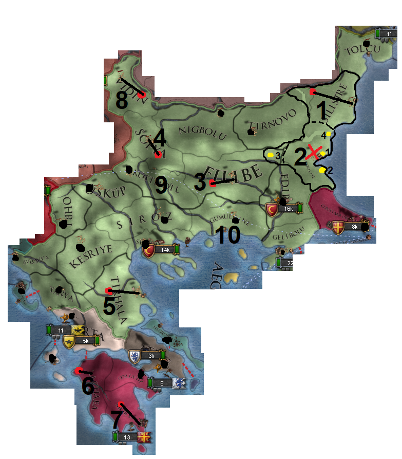
1: Silistre(Tur.)/Silistra(Bul.) should be moved, the borders have to be adjusted as well. The current location of the town is in the location of Constanta (which luckily didn't get added as a separate province).
2: Kirkkilise isn't located there, but in the Edirne province. Burgas is seemingly still the capital, which is wrong. If you guys don't mind a Byzantine-province, call it Mesembria and give it #1 as capital (Nesebar/Mesembria) or call it Sozopol and give it #2 as capital, no border-changes needed. If you guys want it to stay Ottoman, then move the capital to either #3 (Islimiye, border-changes needed to the west) or to #4 (Varna, border-changes needed to the north). I'd personally go for Varna. But, again, the province needs to be edited as it's very flawed.
3: Filibe/Plovdiv should be moved a bit and be beneath the river. It's roughly above the island of Thasos.
4: Sofya should be a bit more to the south-east.
5: Trikala/Tirhala should be the capital of its namesake province; It wasn't a coastal town.
6: Glarentza is currently the capital, but in the wrong location. Funfact: It doesn't exist anymore nowadays.
7: Mystras should be the capital of Morea, not Nafplio. The latter was a Venetian city. Also, both Achaea and Morea could use a namechange, as Achaea and Morea refer to the same peninsula.
8: Vidin should be at a different riverbend. Also; riverbends are kind of wonky, but that's minor at best. The city-location of Vidin is a bigger issue in this case.
9 and 10: Kostendil should be Köstendil and Gumulcine should be Gümülcine.
I've spoken quite a bit with @otaats and we both worked on some Balkan-suggestions, some of his work is shown in this suggestion and other parts (especially city-locations) are things I looked up myself. I hope this is a satisfying list of feedback for your region, my friend!
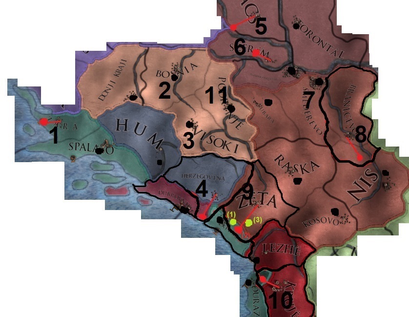
1: Zadar is a coastal city; it should be moved a little. A very minor issue, though.
2: Bosnia/Bosna refers to the river that flows through some of the Bosnian provinces, there are better alternatives. The best one is calling the province Usora. CK2 did the same thing, as well. Doboj, the capital, is in roughly in the middle of the historical region of Usora.
3: Visoki was the name of the fortress that quickly got abandoned a few decades after EU4's beginning, the town beneath was called Visoko and stayed important, also during Ottoman rule. I suggest changing the province-name to Visoko, instead of Visoki.
4: The capital of the 'Herceg' and of Hercegovina ('Land of the Herceg (=duke)') was located at the coast; Herceg Novi (the red dot). Also, it's Hercegovina in Serbian, not Herzegovina. So, the province-name needs a small adjustment as well. The port was quite important and even the Spanish controlled it for a little while.
5: The fortress of Bács should be moved close to the river. This part of the Hungarian kingdom had a lot of Serbian influences, that's why I encompassed it within this suggestion.
6: Mitrovica should be more to the west.
7: Smederevo should be the capital of Serbia; Brankovic just moved in here.
8: Branicevo's capital (Krusevac) isn't located in the current province. Its borders and city-location need to be adjusted.
9: All three of Zeta's capital-choices are (nearly) outside the province. Its current capital is Zabljak, not the big modern city to the north of Montenegro, but Zabljak Crnojevica, a fortress-town. This was fortress was only the capital until 1482, though. #2 indicates the correct location of this town. The bishopric of Cetinje (#1) became the capital of the Prince-Bishopric of Montenegro after the Ottomans had conquered parts of Zeta, they were a thorn in the sides of the Ottomans and de-facto independent most of the times. Zabljak was under steady Ottoman control, that's why Cetinje might be a better alternative. The last option is #3 Podgorica, the most important city and the capital nowadays, but probably a bit too contemporary for the game. This makes Cetinje a really good candidate. It doesn't matter which option is chosen, the borders need to change.
10: Krujë is currently located within the Durazzo province, its borders to the north and the location of its capital need to be adjusted.
11: I hope Srebrenica is the capital of the new Podrinje-province, it was economically very important and regularly changed hands before and a little while after EU4's start because of its silver-mines. The location of the town on the map is already correct, as well. Visegrad could also be its capital, but it should be moved to the south then.
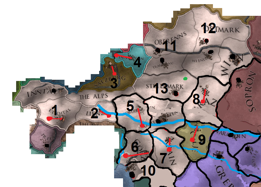
1: If possible, the capital of Meran needs to move a little bit as it was to the east of Innsbruck.
2: Lienz should be closer to the border and the river Drau should be reworked quite a bit. The blue line is just a concept, of course.
3: Salzburg should be more to the south, as it's currently at the same level as Munich.
4: Braunau am Inn should be at the riverjunction and roughly to the north of Salzburg.
5: Oberkärnten's capital (Villach) is way off, the province-borders need to be adjusted and the river Drau (as mentioned earlier) reworked so that it runs to the north of Villach instead of the south. The Drau should also run beneath Klagenfurt instead of above it.
6: As mentioned earlier in the Italy-part; Görz is way off. It wasn't that far inland nor was it coastal, as the current version seems to imply. The province-borders need to look a bit more like the ones in the current version, though. Also, the Soca river needs some changes; it should at least be to the west of Görz.
7: Laibach needs to be more to the south. The Sava river needs to edited, too, and run above Laibach.
8: Graz should be more to the south. Its borders with Celje, Varazdin and Sopron need to be changes, as well.
9: Celje is located too far north, its borders need to be adjusted and the rivers running through it, as well.
10: Triëst's province-shape doesn't cover the Habsburg territories to the south, at all. It needs to merge with the new Rijeka province or there should be two Free-City-sized provinces in that location. Both under Habsburg control, as Rijeka was held by the Lords of Walsee (Habsburg vassals), which had acquired it from the Frankopan's of Croatia a hundred years or so earlier. Direct control by the Habsburgs happened when it was bought from the Lords of Walsee around 1466.
11: Oberenns, which is a correct name, by the way, also covered the new Traungau province. I suggest renaming it to Linz, the capital.
12: Ostmark was a name used by the nazis for a new administrative region of Austria after the Anschluss had happened. The Ostmark was actually a combination of both Viertel ob dem Manhartsberg and Viertel unter dem Manhartsberg (two administrative entities from the era which EU4 covers, named after mountains). I suggest changing the province-name to either Manhartsberg or to its capital; Krems. Manhartsberg has my preference.
13: Graz was the capital of the Steiermark, having Steiermark as its own province is still kind of odd because of that. I suggest changing the name to Judenburg; its capital.
1: As mentioned in the Austria-part; Rijeka either needs to be a mini-province (a bit of the white part shown on the map here above, under Habsburg control) or be merged with Lika. Either way, the island of Krk should be Croatian.
2: Lika should have either Senj (#1) or Gospic (#2) as capital.
@Caligula Caesar Please take a very good look at this; I hope you guys are able to work with it.
Attachments
-
.png) Feedback for Northern Germany (1.29).png592,8 KB · Views: 1.741
Feedback for Northern Germany (1.29).png592,8 KB · Views: 1.741 -
.png) Feedback for Pomerania and the Neumark (1.29).png442 KB · Views: 1.726
Feedback for Pomerania and the Neumark (1.29).png442 KB · Views: 1.726 -
.png) Feedback for Central Germany and Bohemia (1.29).png495,6 KB · Views: 1.708
Feedback for Central Germany and Bohemia (1.29).png495,6 KB · Views: 1.708 -
.png) Feedback for Northern Italy (1.29).png650,2 KB · Views: 1.713
Feedback for Northern Italy (1.29).png650,2 KB · Views: 1.713 -
.png) Feedback for Southern Italy (1.29).png487,7 KB · Views: 1.718
Feedback for Southern Italy (1.29).png487,7 KB · Views: 1.718 -
.png) Feedback for France (1.29).png1,2 MB · Views: 1.742
Feedback for France (1.29).png1,2 MB · Views: 1.742 -
.png) Feedback for Savoy (1.29).png522,5 KB · Views: 1.721
Feedback for Savoy (1.29).png522,5 KB · Views: 1.721 -
.png) Feedback for the Low Countries (1.29).png582,2 KB · Views: 1.723
Feedback for the Low Countries (1.29).png582,2 KB · Views: 1.723 -
.png) Feedback for Southern Germany (1.29).png821,8 KB · Views: 1.709
Feedback for Southern Germany (1.29).png821,8 KB · Views: 1.709 -
.png) Feedback for Rumelia (1.29).png682,8 KB · Views: 1.735
Feedback for Rumelia (1.29).png682,8 KB · Views: 1.735 -
.jpg) Feedback for Serbia and Bosnia (1.29).jpg147,6 KB · Views: 23
Feedback for Serbia and Bosnia (1.29).jpg147,6 KB · Views: 23 -
.png) Feedback for Austria (1.29).png601,2 KB · Views: 1.726
Feedback for Austria (1.29).png601,2 KB · Views: 1.726 -
.jpg) Feedback for Croatia (1.29).jpg37,2 KB · Views: 1.702
Feedback for Croatia (1.29).jpg37,2 KB · Views: 1.702 -
.jpg) Feedback for Serbia and Bosnia (1.29).jpg147,7 KB · Views: 1.726
Feedback for Serbia and Bosnia (1.29).jpg147,7 KB · Views: 1.726
Last edited:
- 4

- 1