• We have updated our Community Code of Conduct. Please read through the new rules for the forum that are an integral part of Paradox Interactive’s User Agreement.
The blue is the monarchs journey thing.

As you have replaced the files in the map folder it's impossible for the vanilla map to be loading if your mod was actually active. So you .mod file is probably pointing to the wrong location.

OH. Well, you're completely right— I just double checked the .mod and I had a duplicate of it that was messing it up. Thank you so much, I don't know how I missed something that obvious.
 
And onto a new issue! So, I've been scouring the web for mentions of people having trouble with the rivers.bmp map file (which is what I assume is causing the problem) to no avail.

Code:
[pdxmapgeneration.cpp:224]: Too small river found at 2, 2048
[pdxmapgeneration.cpp:224]: Too small river found at 3, 2048

My graphics.log has over 4 million lines dedicated to saying that "too small [of a] river found" at X, Y. I'm also CTDing at loading graphics. Oh! and it also says that there are circular rivers.

So far I've tried removing the river map file, redoing it and copying over the vanilla river file, editing the default.map file and made sure that I have the file using the proper format and indexed colors. In addition, the validation tool is not spotting any errors that would point to this, so I'm at a standstill. Any ideas what might be going on? My rivers.bmp is attached should anyone wish to take a look.

EDIT: [FIXED] For anyone else that comes across this error make sure that you have a "positions.txt" and it is properly named.
 

Attachments

  • Annotation 2020-02-04 003832.png
    Annotation 2020-02-04 003832.png
    138,3 KB · Views: 11
Last edited:
What is probably causing this? Its not my colormaps or topology as far as I can tell.

There is water everywhere on the land portion of the map, even if it is not underwater.
 

Attachments

  • Annotation 2020-02-04 003832.png
    Annotation 2020-02-04 003832.png
    2,4 MB · Views: 19
What is probably causing this? Its not my colormaps or topology as far as I can tell.

There is water everywhere on the land portion of the map, even if it is not underwater.
A bunch of rivers flowing east to west like that generally means that there is something wrong with the color index of rivers.bmp.
 
A bunch of rivers flowing east to west like that generally means that there is something wrong with the color index of rivers.bmp.

Seems like you were spot on about rivers.bmp being off. I noticed a few sneaky green pixels on closer look so, I fixed that up and then it caused a CTD. I then copied over the vanilla rivers.bmp and it still had the issue with the rivers flowing east to west; redid the map completely and then it CTDs; manually added the colors to the color table for the index and then it started up! but the rivers are still flowing from east to west.
 

Attachments

  • rivers.7z
    46,8 KB · Views: 4
Seems like you were spot on about rivers.bmp being off. I noticed a few sneaky green pixels on closer look so, I fixed that up and then it caused a CTD. I then copied over the vanilla rivers.bmp and it still had the issue with the rivers flowing east to west; redid the map completely and then it CTDs; manually added the colors to the color table for the index and then it started up! but the rivers are still flowing from east to west.
It might have to do something with that weird line of "River Sources" ending in a "Minor River source from Major River" in the southwest island.
 
It might have to do something with that weird line of "River Sources" ending in a "Minor River source from Major River" in the southwest island.
Oh that must've happened when I edited the color table. Hmm, fixed and still has the east to west flow tho. I'll keep looking around in rivers for other things I've missed— thanks for spotting that.
 
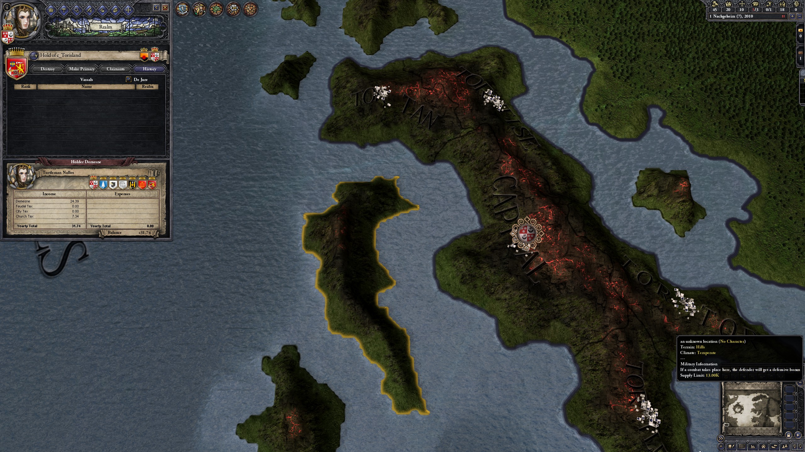
So I've been trying to add some provinces to the Warhammer mod, and I've run into some issues. Currently, my problem is this:
20200208231347_1.jpg
20200208231614_1.jpg


This province, the last in the list of ones added, does not seem to want to work. Before, when one of the other provinces didn't work, this one appear as the place but didn't have any holdings. Then, after I fixed the other province, it decided to just recognize as PROV2509, then now that I changed its name and colour, it seemingly recognizes that the title of c_Torisland is at that location, but sees that province as "an unknown location"

Any help? This is seriously confusing
 
A bunch of rivers flowing east to west like that generally means that there is something wrong with the color index of rivers.bmp.

Hello, sorry to be a bother. I've tried recreating the rivers.bmp from scratch and I made sure there were no more random sources of green pixels like you found last time but, the wtaer is still flowing across the map. I've also tried redoing the terrain.bmp and the colormaps but it hasn't changed much and certainly it hasn't fixed the issue I'm having with the water. Can you— or anyone else really, please take a quick look? I've been at a standstill since last Wednesday with this.
 

Attachments

  • Annotation 2020-02-04 003832.png
    Annotation 2020-02-04 003832.png
    2,4 MB · Views: 8
  • tdp.7z
    4,6 MB · Views: 5
Hello, sorry to be a bother. I've tried recreating the rivers.bmp from scratch and I made sure there were no more random sources of green pixels like you found last time but, the wtaer is still flowing across the map. I've also tried redoing the terrain.bmp and the colormaps but it hasn't changed much and certainly it hasn't fixed the issue I'm having with the water. Can you— or anyone else really, please take a quick look? I've been at a standstill since last Wednesday with this.
What program are you using to draw that map? Is it paint.net? That one automatically screws up the colour index as soon as you save.
 
Hello, sorry to be a bother. I've tried recreating the rivers.bmp from scratch and I made sure there were no more random sources of green pixels like you found last time but, the wtaer is still flowing across the map. I've also tried redoing the terrain.bmp and the colormaps but it hasn't changed much and certainly it hasn't fixed the issue I'm having with the water. Can you— or anyone else really, please take a quick look? I've been at a standstill since last Wednesday with this.
The way that I handle the rivers map is probably dumb.
Instead of exporting it directly form an image editing software. I open rivers.bmp using Visual Studio and copy over the rivers layer into Visual Studio.
 
No luck with your method
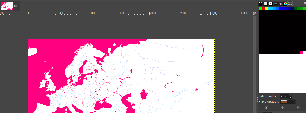
Your colour indexing is messed up. Here's what the vanilla map's colourmap looks like in Gimp:
upload_2020-2-11_18-7-54.png

And here's yours:
upload_2020-2-11_18-8-25.png

So you're using at least some of the same colours, but in the metadata they are indexed in the wrong order.

I attached the fixed version (I changed the extension to txt because of silly Paradox forum upload format restrictions, just change it back to bmp on your end). Try to google for colourmap indexing solutions for Photoshop, or use Gimp for the rivermap which I know for a fact preserves the colour indexing well.
 

Attachments

  • rivers.txt
    6 MB · Views: 5
Your colour indexing is messed up. Here's what the vanilla map's colourmap looks like in Gimp:
View attachment 544542
And here's yours:
View attachment 544543
So you're using at least some of the same colours, but in the metadata they are indexed in the wrong order.

I attached the fixed version (I changed the extension to txt because of silly Paradox forum upload format restrictions, just change it back to bmp on your end). Try to google for colourmap indexing solutions for Photoshop, or use Gimp for the rivermap which I know for a fact preserves the colour indexing well.
It was still the Index, really? Thats insane. I was using the vanilla ck2 rivers.bmp too because of that.

I'm sorry for bothering you with this then since it was like you originally said— the index. Still, thank you. I'll be sure to look for indexing solution for Photoshop. And I'll update the wiki in-case anyone else has this problem.
No problem. I had the same issue before and it turned out to be the index, but I was using Paint.net which is a bit simple and just doesn't preserve those indices. For Photoshop to have the same issue, I wouldn't have expected that either.
 
It seems the colormap.dds is limited to 8192x8192 (or at least my video card is limiting it to that). Is there anyway to mod the game to take multiple files as texture for the map? Like a colormapNE.dds,colormapSE.dds, colormapSW.dds, colormapNW.dds? Or is there a way to get the game to take a scaled version of colormap.dds kind of like how trees.bmp is ~1/8th the size of province.bmp? I'm trying to make a bigger map but seems like the single texture for colormap/colormap_water limits it to 8192x8192.
 
It seems the colormap.dds is limited to 8192x8192 (or at least my video card is limiting it to that). Is there anyway to mod the game to take multiple files as texture for the map? Like a colormapNE.dds,colormapSE.dds, colormapSW.dds, colormapNW.dds? Or is there a way to get the game to take a scaled version of colormap.dds kind of like how trees.bmp is ~1/8th the size of province.bmp? I'm trying to make a bigger map but seems like the single texture for colormap/colormap_water limits it to 8192x8192.
AFAIK colour maps are scaled automatically. You could have one that's four by four pixels.