I had a slight little hope that Hungary will see some love in this European Update, but only the croatian part had been touched. Since, with the past patches every neighbour of Hungary have been updated (Poland, romanian duchies, and now Austria, Bohemia, and the south slavic region), and I was disappointed with the 'Hungarian Patch' from a few years ago, and @neondt recently said:
I just can't disagree more. So I created this thread.
How could a yaers old patch, which was mitigated to match all it's still pre-updated neighbours' strength, leave it in a good place in terms of performance and province density? The Kingdom of Hungary, with Croatia included had like 4 million inhabitants around the start of the game, when England, (with Wales and half Ireland), had like 2,75 million, yet has 31 provinces.
With the detachment of Croatia, Hungary will have 24 provinces, I'd like to see that around 30. We've got development to represent the advancement of regions, I feel like such a sharp difference in province density between Austria and Hungary is rather wrong for the time:

With the correct redrawing of the river Drava, it can clearly be seen how enormous Somogy and Sopron are. Not to mention whole Dunántúl/Transdanubia (west of the river Danube) is just 3 province. The richest and traditionally most popolous region of the country, bigger than Tuscany, yet just 3 provinces. Upper Hungary, later Slovakia, could also be broken up into 2 states, and Transylvania's borders are not even close to the historical ones, as Hunayad, Bihar and Maramaros were not part of it.
There's my version:
1. Overwiev

I don't think it would be too crowded, compared to the new Balkans and Austria.
Now Maros, Torda, Királyföld and Hunyad, with two new provinces, form Transylvania. It's already split in two: Upper (Torda, Maros, and the new Beszterce), and Lower (Hunyad, Királyföld, and the new Fehér).
Next I'd make Slovakia/Upper Hungary a five province state with the old Pozsony, Szepes, Trencsén and Hont, and with the new Zólyom. Zemplén and Máramaros, with Bereg "squeezed" between them form the new 'Kárpátalja/Zakarpattia' state. Dunántúl/Transdanubia needs a new province desperately, I choose Zala between Sopron and Somogy. The Alföld also got some love, Szatmár/Sathmar detached from the seriously oversized Bihar. The former is plains, the latter hills. Arad also got squeezed between Békés, Temes and Bihar. It was an important town and Temes (together with Torontál) now match the Banat of Temes.
Note, how besides splitting the huge wasteland of the Carpathian Range, I added a few more wastelands. First, the Tatra in Upper Hungary-Slovakia, and the Southern Carpathian Range north of Severin. These are definately worthy of being wastelands, with 2000 meters tall peaks.

2. The new provinces

I tried to add really only the most necessary ones, and if we count with some reshuffling of development, let's say 8 times 6 development will be added, that's 48.
Currently Hungary has 210 development at the start of the game, of which is 182 Hungary and 28 by the current meta will be Croatia. So the great power rating will be 196.
Now that 182 with the the addition of 48 is 230. With the 50% of Croatia's 28 development, 244 gp rating.
Still 22 shorter to the Grand Duchy of Lithuania, the weakest great power, which actually had a population like half the size of Hungary, despite being huge.
If someone fears Hungary would be too strong (which I highly doubt, between the PLC, Ottomans and the HRE), Transylvania could be moved to be a lesser union partner or some subject type, similar to what France will get, probably. Or some other ways to represent the level of autonomy of the region.
3. Economics:
Medieval Hungary's economy depended on these goods above all: The hundreds of thousands of cattles, raised on the Alföld and imported to Germany, and the great amound of salt mined if Transylvania. So I'd like to represent those foremostly, besides some wine, grain and metal producing provinces. Metal producing was prevalent in the Upper Hungarian mining towns, while in the eastern carpathian, there were pastoral Vlach, Ruthenian and Hungarian communities.
Also, cities were relatively small at the time, compared to Western Europe, the capital had around 15 thousand inhabitants, other 'Free Royal Cities' around 5-10 thousand.
4. Areas
A possible setting of areas:
Orange: Upper Hungary (Felvidék)
Light Green: Subcarpathia (Kárpátalja)
Turquise: Northern Transylvania (Észak-Erdély)
Dark Green: Southern Transylvania (Dél-Erdély)
Red: Partium
Blue: Northern Alföld (Észak-Alföld)
Yellow: Southern Alföld (Dél-Alföld)
Pink: Transdanubia (Dunántúl)
With these provinces it's possible to represent all the major divisions of the timeline, most importantly the Three Hungary: Habsburg Upper, independent Transylvania, and Ottoman-occupied central-Alföld.
5. Cultures
I'd disintegrate the Transylvanian culture, and represent Hungarian, Romanian and Saxon populations.
Saxons obviously should be in Királyföld, and the new Beszterce, and I'd make Temes, Hunyad, Arad and Bihar Romanian culture.
I'm fine with Slovak and South Slavic cultures, and I think the new Bereg province should rather be Hungarian, than one more Ruthenian.

Green: Slovak, Orange: Ruthenian, Blue: Saxon, Yellow: Romanian. I would leave south slavic as it is currently.
Alternatively, as Eu4 has a tendency to represent the ruling class, all non-Saxon province in Transylvania could start as Hungarian, and the mentioned ones turn Romanian with that event around 1650. But I think it should just start somehow like the maps show.
@neondt, @Caligula Caesar, @Ofaloaf I hope you guys are willing to give the Hungarian Kingdom's map a decent rework, don't leave it in such a condition as it is now. Some events can't compensate for an awfully uncorrect and undetailed map. With the detachment of Croatia there must be room for some (not too much, just the minimal necessary) development added")
We feel that the Hungary patch left the Hungarian province setup in a good place in terms of performance and province density. We see no need to fix what isn't broken. Though we'll certainly be looking at other kinds of content for Hungary.
I just can't disagree more. So I created this thread.
How could a yaers old patch, which was mitigated to match all it's still pre-updated neighbours' strength, leave it in a good place in terms of performance and province density? The Kingdom of Hungary, with Croatia included had like 4 million inhabitants around the start of the game, when England, (with Wales and half Ireland), had like 2,75 million, yet has 31 provinces.
With the detachment of Croatia, Hungary will have 24 provinces, I'd like to see that around 30. We've got development to represent the advancement of regions, I feel like such a sharp difference in province density between Austria and Hungary is rather wrong for the time:
With the correct redrawing of the river Drava, it can clearly be seen how enormous Somogy and Sopron are. Not to mention whole Dunántúl/Transdanubia (west of the river Danube) is just 3 province. The richest and traditionally most popolous region of the country, bigger than Tuscany, yet just 3 provinces. Upper Hungary, later Slovakia, could also be broken up into 2 states, and Transylvania's borders are not even close to the historical ones, as Hunayad, Bihar and Maramaros were not part of it.
There's my version:
1. Overwiev
I don't think it would be too crowded, compared to the new Balkans and Austria.
Now Maros, Torda, Királyföld and Hunyad, with two new provinces, form Transylvania. It's already split in two: Upper (Torda, Maros, and the new Beszterce), and Lower (Hunyad, Királyföld, and the new Fehér).
Next I'd make Slovakia/Upper Hungary a five province state with the old Pozsony, Szepes, Trencsén and Hont, and with the new Zólyom. Zemplén and Máramaros, with Bereg "squeezed" between them form the new 'Kárpátalja/Zakarpattia' state. Dunántúl/Transdanubia needs a new province desperately, I choose Zala between Sopron and Somogy. The Alföld also got some love, Szatmár/Sathmar detached from the seriously oversized Bihar. The former is plains, the latter hills. Arad also got squeezed between Békés, Temes and Bihar. It was an important town and Temes (together with Torontál) now match the Banat of Temes.
Note, how besides splitting the huge wasteland of the Carpathian Range, I added a few more wastelands. First, the Tatra in Upper Hungary-Slovakia, and the Southern Carpathian Range north of Severin. These are definately worthy of being wastelands, with 2000 meters tall peaks.
2. The new provinces
Corrected capitals in grey, new provinces' capital in yellow:
(province-city-terrain: notes)
1. Zólyom - Zólyom - Mountains: The most important mining region of the country, rich in silver, gold, copper and iron aswell. There were important gold mines, I'd pick that, and move gold from Hont to this province.
2. Bereg - Beregszász - Hills: Culture could be Ruthenian also, but I think Maramaros is enough, leave it Hungarian.
3. Szatmár - Szatmárnémeti - Plains: There was an important salt mine, alternatives are livestock, wine and grain.
4. Beszterce - Beszterce - Mountains: Important ironworking town with German population and a new pass on the Carpatian Range: Borgói/Tihuta-pass https://en.wikipedia.org/wiki/Tihuța_Pass
5. Fehér/Torda - Gyulafehérvár - Highlands: there were also salt mines, was capital of Transylvania. Existing Torda renamed to Kolozs.
6. Arad - Arad - plains: Heavily fought over during the Ottomand wars. Romanian or Hungarian culture.
7. Kunság - Szolnok - Plains: Lands of the Jassic and Cuman people, who migrated there fleeing the marauding mongols in the 13th century. Their integration was a slow process. https://en.wikipedia.org/wiki/Kunság
8. Zala - Zalaegerszeg - Woodland: Became part of Habsburg-controlled Upper Hungary, also important wine region.
I still left out a lot of possible nice provinces: Esztergom, the seat of the bishop, Kassa, the most important city in Upper Hungary after Pozsony, Baranya, the eastern half of current Somogy, with Pécs, where the first hungarian university was, or splitting Bács, so contemporary Serbian-Hungarian border can be achieved, etc.. So it's quite the conservative solution.
With red hexagon, correctly placed capitals, with green hexagon, corrected/new capitals.
(province-city-terrain: notes
9. Nyitra-Érsekújvár/Nyitra-farmlands: culture Hungarian or Slovakian
10. Pozsony-Pozsony-farmlands: the city had an overwhelmingly german population until the 18th century.
11. Trencsén-Trencsén-Hills: wrong side of the river
12. Szepes-Lőcse-Hills: Lot of germans lived there
13. Zemplén-Kassa-Hills: Culture Hungarian or Slovakian
14. Szabolcs-Debrecen-Plains: Debrecen was historically in the western tip of Bihar county, before it became the capital of the new Hajdu County in 1876.
15. Bihar-Nagyvárad-Hills: Culture probably Romanian
16. Kolozs-Kolozsvár-Highlands: Culture probably Hungarian. Current Center of Trade.
17. Máramaros-Máramarossziget-Mountains: Rahó is a less difficult capital candidate. Ruthenian
18. Maros-Marosvásárhely-Mountains: Culture Hungarian.
19. Királyföld-Brassó-Highlands: Culture (Transylvanian) Saxon. Potential Center of Trade.
20. Hunyad-Vajdahunyad-Hills: Culture Romanian or Hungarian.
21. Temes-Temesvár-Farmlands: Culture Romanian or Hungarian.
22. Torontál-Nagybecskerek-Farmlands: Culture Hungarian.
23. Csanád-Szeged-Farmlands: Potential Center of Trade.
24. Bács-Szabadka-Farmlands: Culture Hungarian.
25. Fejér-Fehérvár-Farmlands.
26. Pest-Buda-Farmlands: Curremt Center of Trade.
27. Heves-Eger-Hills/Plains: Wine region.
28. Somogy-Kaposvár-Woodland:
29. Sopron-Sopron-Farmlands.
I tried to add really only the most necessary ones, and if we count with some reshuffling of development, let's say 8 times 6 development will be added, that's 48.
Currently Hungary has 210 development at the start of the game, of which is 182 Hungary and 28 by the current meta will be Croatia. So the great power rating will be 196.
Now that 182 with the the addition of 48 is 230. With the 50% of Croatia's 28 development, 244 gp rating.
Still 22 shorter to the Grand Duchy of Lithuania, the weakest great power, which actually had a population like half the size of Hungary, despite being huge.
If someone fears Hungary would be too strong (which I highly doubt, between the PLC, Ottomans and the HRE), Transylvania could be moved to be a lesser union partner or some subject type, similar to what France will get, probably. Or some other ways to represent the level of autonomy of the region.
3. Economics:
Medieval Hungary's economy depended on these goods above all: The hundreds of thousands of cattles, raised on the Alföld and imported to Germany, and the great amound of salt mined if Transylvania. So I'd like to represent those foremostly, besides some wine, grain and metal producing provinces. Metal producing was prevalent in the Upper Hungarian mining towns, while in the eastern carpathian, there were pastoral Vlach, Ruthenian and Hungarian communities.
Also, cities were relatively small at the time, compared to Western Europe, the capital had around 15 thousand inhabitants, other 'Free Royal Cities' around 5-10 thousand.
Yellow squares represent trade centers. All of them lvl1 on the picture except maybe Wien.
Besides Pest and Kolozs, there should be at least one more trade center, my pick would be Szeged (in current Békés) and/or Brassó (in current Királyföld). The former was important salt trading port at the confluence of the Maros and the Tisza rivers, the second was a Transylvanian town, which had a role in trade towards Constantinople. I think both deserves it (not like Pozsony/Pressburg, which became important later), but if I had to choose I'd pick Szeged for it's central position.
I also added a center to Nicopolis in Bulgaria.
So overall I added 54 development to Hungary for now, mostly by 8 new provinces, and reshuffled existing development to mirror regional differences better.
If someone is concerned 54 is too much, it could be decreased somewhat, but not without creating unhistorically undeveloped areas. It's already very lame how in Russia there are 10+ development provinces, but basically none in Hungary.
Province name: development (dev. change)
If someone is concerned 54 is too much, it could be decreased somewhat, but not without creating unhistorically undeveloped areas. It's already very lame how in Russia there are 10+ development provinces, but basically none in Hungary.
Province name: development (dev. change)
A quite rich part of the country, with many important mining towns in Zólyom, so it worthy of having at least 10 development. Pozsony/Pressburg/Bratislava on the other hand wasn't so important or rich.
Pozsony: 9 (-4)
Trencsén: 6 (0)
Hont: 9 (0)
Zólyom: 10 (new, +10)
Szepes: 7 (-2)
Pozsony: 9 (-4)
Trencsén: 6 (0)
Hont: 9 (0)
Zólyom: 10 (new, +10)
Szepes: 7 (-2)
Probably the least developed part of the country.
Zemplén: 6 (-1)
Bereg: 5 (new, +5)
Máramaros: 4 (-1)
Zemplén: 6 (-1)
Bereg: 5 (new, +5)
Máramaros: 4 (-1)
Kolozs (old Torda province) is the center of Transylvania, should have lvl1 trade center& at least 9 development.
Kolozs: 9 (+3)
Beszterce: 6 (new, +6)
Maros: 6 (-2)
Kolozs: 9 (+3)
Beszterce: 6 (new, +6)
Maros: 6 (-2)
Királyföld, with large Saxon population, was one of the richest region.
Királyföld: 9 (+1)
Fehér: 7 (new, +7)
Hunyad: 6 (-2)
Királyföld: 9 (+1)
Fehér: 7 (new, +7)
Hunyad: 6 (-2)
Bihar, a hilly region with dense forests has a low development for a reason, the rest not much higher either. Temesvár rose to importance later.
Szatmár: 6 (new, +6)
Bihar: 5 (0)
Arad: 7 (new, +7)
Temes: 7 (-1)
Szatmár: 6 (new, +6)
Bihar: 5 (0)
Arad: 7 (new, +7)
Temes: 7 (-1)
Pest, the capital was quite developed, or at least developed than Pozsony/Pressburg/Bratislava back then, which rose to prominence in the 18th century. The new Szolnok province is inhabited by the Cumans, not so developed, so only 6 dev.
Pest: 13 (+2)
Eger: 7 (-1)
Szabolcs: 7 (-1)
Szolnok: 6 (new, +6)
Pest: 13 (+2)
Eger: 7 (-1)
Szabolcs: 7 (-1)
Szolnok: 6 (new, +6)
With very good quality soil, this region should have at least 6-7 development, not 5, as currently.
Bács: 7 (+2)
Torontál: 7 (-1)
Békés: 9 (+3)
Bács: 7 (+2)
Torontál: 7 (-1)
Békés: 9 (+3)
The richest region of the country, at least 3/3/3 for them, except Zala, where 3/3/2 is enough. Zala 3/3/4, it had a high population density. So 9 dev on average.
Sopron: 9 (+1)
Fejér: 9 (+1)
Somogy: 10 (+2)
Zala: 8 (new, +8)
Sopron: 9 (+1)
Fejér: 9 (+1)
Somogy: 10 (+2)
Zala: 8 (new, +8)
Slavonia state: (+2 development for Croatia)"
Slavonia: 6(+1) (to be renamed Kőrös/Pozsega)
Varasd: 6 (+1)
Belovár: 5 (+1)
Szerém: 5 (0)
Croatia: (+0 development)
Lika's 12 development divided between Lika (mountainous, low population) and the new Rijeka (important port). Aswell might be 8-4.
Zagreb: 7 (0)
Rijeka: 7 (0)
Lika: 5 (0)
Slavonia: 6(+1) (to be renamed Kőrös/Pozsega)
Varasd: 6 (+1)
Belovár: 5 (+1)
Szerém: 5 (0)
Croatia: (+0 development)
Lika's 12 development divided between Lika (mountainous, low population) and the new Rijeka (important port). Aswell might be 8-4.
Zagreb: 7 (0)
Rijeka: 7 (0)
Lika: 5 (0)
4. Areas
A possible setting of areas:
Orange: Upper Hungary (Felvidék)
Light Green: Subcarpathia (Kárpátalja)
Turquise: Northern Transylvania (Észak-Erdély)
Dark Green: Southern Transylvania (Dél-Erdély)
Red: Partium
Blue: Northern Alföld (Észak-Alföld)
Yellow: Southern Alföld (Dél-Alföld)
Pink: Transdanubia (Dunántúl)
With these provinces it's possible to represent all the major divisions of the timeline, most importantly the Three Hungary: Habsburg Upper, independent Transylvania, and Ottoman-occupied central-Alföld.
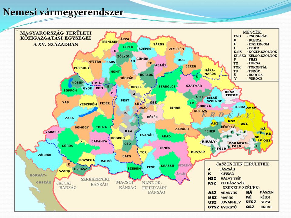
Golden Age of Hungary:

This map, besides most of Europe, also show's how was the administrative division of the Kingdom back then around 1490.
Divided Hungary:
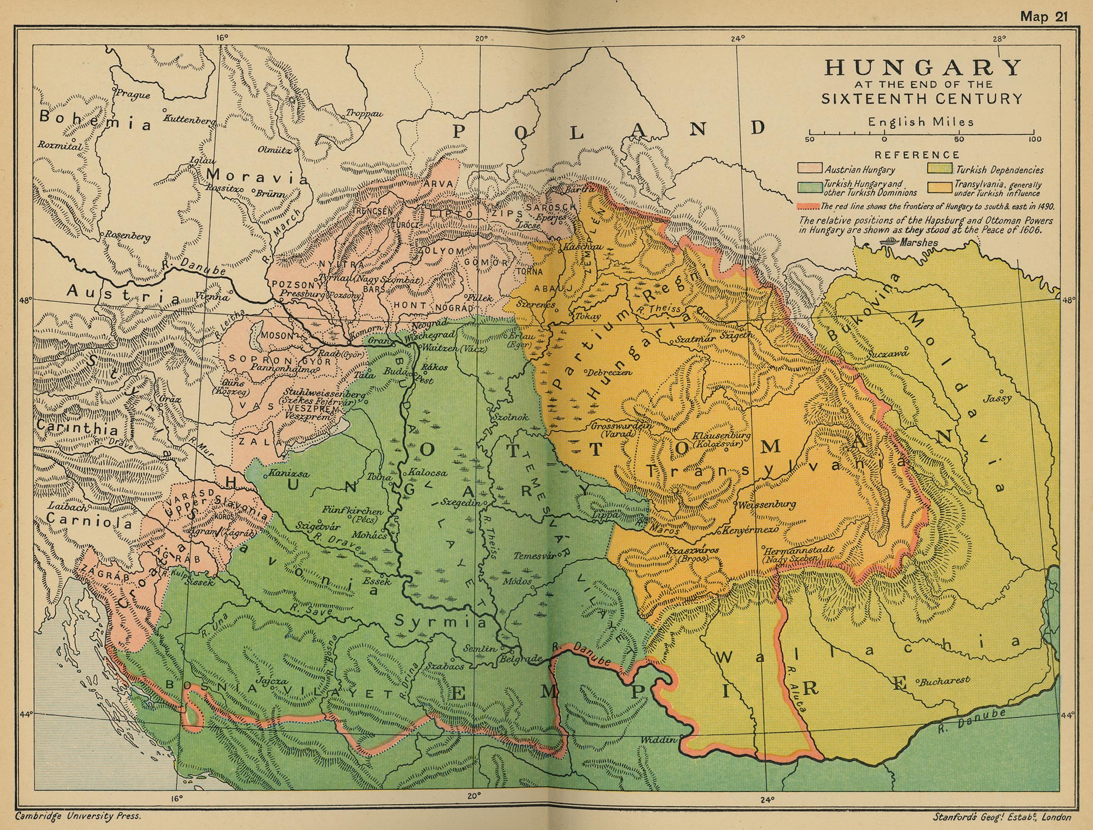
The three Hungary. The Ottomans conquered the plains, but couldn't get over the mountainous upper parts of the country, which accepted Habsburg control. Meanwhile, in the east, far from Wien's reach, Transylvania tried to maintain peace with the Ottomans, expanded northwest, benefiting from anti-Habsburg movements.
https://en.wikipedia.org/wiki/Kingdom_of_Hungary_(1526–1867)
https://en.wikipedia.org/wiki/History_of_Transylvania
https://en.wikipedia.org/wiki/Ottoman_Hungary
Banat, the last part of the country to be freed from the Ottomans, in 1716:

https://en.wikipedia.org/wiki/Banat
This map, besides most of Europe, also show's how was the administrative division of the Kingdom back then around 1490.
Divided Hungary:
The three Hungary. The Ottomans conquered the plains, but couldn't get over the mountainous upper parts of the country, which accepted Habsburg control. Meanwhile, in the east, far from Wien's reach, Transylvania tried to maintain peace with the Ottomans, expanded northwest, benefiting from anti-Habsburg movements.
https://en.wikipedia.org/wiki/Kingdom_of_Hungary_(1526–1867)
https://en.wikipedia.org/wiki/History_of_Transylvania
https://en.wikipedia.org/wiki/Ottoman_Hungary
Banat, the last part of the country to be freed from the Ottomans, in 1716:
https://en.wikipedia.org/wiki/Banat
5. Cultures
I'd disintegrate the Transylvanian culture, and represent Hungarian, Romanian and Saxon populations.
Saxons obviously should be in Királyföld, and the new Beszterce, and I'd make Temes, Hunyad, Arad and Bihar Romanian culture.
I'm fine with Slovak and South Slavic cultures, and I think the new Bereg province should rather be Hungarian, than one more Ruthenian.
Green: Slovak, Orange: Ruthenian, Blue: Saxon, Yellow: Romanian. I would leave south slavic as it is currently.
Alternatively, as Eu4 has a tendency to represent the ruling class, all non-Saxon province in Transylvania could start as Hungarian, and the mentioned ones turn Romanian with that event around 1650. But I think it should just start somehow like the maps show.
https://en.wikipedia.org/wiki/Principality_of_Transylvania_(1570–1711)

Transylvania had a lot of inhabitants throughout the timeline. Long story short: Even the Romans had outposts there, then in the Migration Period first the Visigothic Kingdom stood there, then it was part of the Hunnic Empire, then an other germanic tribe, the Gepids ruled it, after them, the Avars, who were probably a turkic tribe. They allowed slavic immigration, but then the Bulgarians defeated them and incorporated Transylvania to their Empire, just for the Moravians to rebel against them. Then around 900 Hungarians conquered the whole Carpathian Basin.
The Szeklers arrived in the 12th century to Transylvania as border guards, and the Saxons in the 12th and 13th centuries, the South Slavs and Vlachs started to settle in great numbers the southern and eastern parts of the country around the Ottoman wars.
https://en.wikipedia.org/wiki/History_of_Transylvania

Here: Red: Hungarian, Blue: Saxon, Yellow: Vlach, Orange: Slavic
Transylvania had a lot of inhabitants throughout the timeline. Long story short: Even the Romans had outposts there, then in the Migration Period first the Visigothic Kingdom stood there, then it was part of the Hunnic Empire, then an other germanic tribe, the Gepids ruled it, after them, the Avars, who were probably a turkic tribe. They allowed slavic immigration, but then the Bulgarians defeated them and incorporated Transylvania to their Empire, just for the Moravians to rebel against them. Then around 900 Hungarians conquered the whole Carpathian Basin.
The Szeklers arrived in the 12th century to Transylvania as border guards, and the Saxons in the 12th and 13th centuries, the South Slavs and Vlachs started to settle in great numbers the southern and eastern parts of the country around the Ottoman wars.
https://en.wikipedia.org/wiki/History_of_Transylvania
Here: Red: Hungarian, Blue: Saxon, Yellow: Vlach, Orange: Slavic
@neondt, @Caligula Caesar, @Ofaloaf I hope you guys are willing to give the Hungarian Kingdom's map a decent rework, don't leave it in such a condition as it is now. Some events can't compensate for an awfully uncorrect and undetailed map. With the detachment of Croatia there must be room for some (not too much, just the minimal necessary) development added
Last edited:
- 2
Upvote
0