

Wasn't the Second Triumvirate the alliance between Marc Antony, Octavian and Lepidus which rather expired somewhat before the Battle of Actium?
Map Changes Thread
- Thread starter Hardradi
- Start date
-
We have updated our Community Code of Conduct. Please read through the new rules for the forum that are an integral part of Paradox Interactive’s User Agreement.
You are using an out of date browser. It may not display this or other websites correctly.
You should upgrade or use an alternative browser.
You should upgrade or use an alternative browser.
amazing! *drools*...sorry i can't help you with that...
i noticed 2 things... Samarkand (Marakanda) was the capital of Sogdiana... what does the Sogdiana province represent?
Good question, I did a reshuffle a few nights ago and I think you are right. Sogdiana should be Samarkand with Marakanda as the capital. The other Sogidian province (in the extreme northeast) would have Alexandria Eschate as the capital. I just dont have a name for it yet - Jaxartes/Fergana/Kyreschata. I think I prefer Kyreschata, the name of the old Persian town of the area. The Jaxartes River also has to be moved further to the southwest.
Beyond the Jaxartes to the north is the Hunger Steppe. Would you agree?
Also are you sure that in 474 Drangiana and Aria were under Mauryan rule? I think most sources state Seleucus gave Chandragupta Arachosia, Gedrosia and Gandhara (and maybe Peropamisus) but i think he kept Drangiana and Aria...
Not sure though
There is lots of assertion around the place that he received Aria but no mention is made of Drangiana. On a lot of Mauryan empire maps, they are shown to control this area. Also they were jointly controlled by the satrap Stasander. You may be right.
For now I think I will leave it with the Mauryans, simply to boost their power and reduce Seleucid power. If you find anything to the contrary, I would like to know.as for indo-greek and greco-bactrian cultures, i think it's fair enough. It's true that Seleucids were deeply involved in creating greek colonies in the area (i.e. Antiochia Margiana), but it seems they always resorted to settle a part of greeks and a part of locals... this mixture could be represented as Greco-bactrians and indo-greek. However i would probably keep this 2 cultures in the greek culture group.
Agreed.
The map is still pretty ugly with regards to province positioning vs the terrain, but this can be improved later.
Thanks for the support and interest.
Wasn't the Second Triumvirate the alliance between Marc Antony, Octavian and Lepidus which rather expired somewhat before the Battle of Actium?
Yes. Mental slip up, I thought the second series finished before Actium. Now that hollow feeling you get when a good show finishes is not so hollow.
Have you seen "I, Claudius"?
The book is better but the series was excellent although now quite dated.
Good question, I did a reshuffle a few nights ago and I think you are right. Sogdiana should be Samarkand with Marakanda as the capital. The other Sogidian province (in the extreme northeast) would have Alexandria Eschate as the capital. I just dont have a name for it yet - Jaxartes/Fergana/Kyreschata. I think I prefer Kyreschata, the name of the old Persian town of the area. The Jaxartes River also has to be moved further to the southwest.
Beyond the Jaxartes to the north is the Hunger Steppe. Would you agree?
There is lots of assertion around the place that he received Aria but no mention is made of Drangiana. On a lot of Mauryan empire maps, they are shown to control this area. Also they were jointly controlled by the satrap Stasander. You may be right.
Agreed.
The map is still pretty ugly with regards to province positioning vs the terrain, but this can be improved later.
Thanks for the support and interest.
Yes. Mental slip up, I thought the second series finished before Actium. Now that hollow feeling you get when a good show finishes is not so hollow.
Have you seen "I, Claudius"?
The book is better but the series was excellent although now quite dated.
The region with Alexandria Eschate could be Kyreschata or just Eschata, something that means the ultimate boundary as it was. It's now Khojend, on the Syrdarya (Jaxartes) in Tagikistan. So yes the Jaxartes should be moved a little bit south... to the north east in what is now terra incognita it should be Fergana, the fertile valley which was not under Seleucid rule (at least permanently), but it was colonized by the Bactrians. To the north of Eschata it would be Chach (Tashkent), a very mountainous area, to the west Sogdiana as it is. To the north of Sogdiana is the Hunger Steppe, to the west of Sogdiana the Kyzylkum Desert... I don't know which cities were in the Hunger steppe and Kyzylkum, maybe the Sogdian Rock was somewhere there... You can have a look at Magna Terra for the area, it's pretty accurate i think.
About Aria and Drangiana, if one was somewhere the other followed i think, they look a bit isolated from the rest...
i've also seen in some cases they are put under Mauryan rule after at the start date so it should be ok.You're too good for the Rome community's best Hardradi, you might well be overwriting the developers' expansion plans now. Great job!
Great job!Thanks mate. They probably dont even know.
I am back at work now, so things are slowing down. A couple more dedicated weekends and I think it might be ready for release.
I am back at work now, so things are slowing down. A couple more dedicated weekends and I think it might be ready for release.
Been busy and taking a bit of a break to give the spouse some attention.
BUT I have added 10 more provinces into the original vanilla map, a few additional nations and Spartan reforms. Also I am continuting to refine the map expansion for population, adding regions, climates, vanilla map adjustments, etc.
Its on track and I will definately get it out before Xmas even if I am not entirely happy about it being finished.
This is my to do list:
1) Clear away Aral Sea terrain
2) Attempt to realign terrain map to topography
2) Fix Drangiana lakes
3) Add Tochari/Saka invasion events (ala beefed up version of old Parthia event)
4) Figure out what tribes invaded the Dahae/Parni lands after the Parni formed Parthia in the south and add them
4) Re-check population and cultures
5) Test
6) Figure out what vanilla files will be overwritten with the installation
7) Write installation instructions
8) Test installation
In case you haven't finished it already:
On who assumed control of the former Parni lands, from what I've read it seems as if the Dahae actually stayed behind, and some people called Apasiaca/Apasiacae ( http://en.wikipedia.org/wiki/Apasiacae ) moved in from the north, though they seemed to have lived in Alania as well. Apparently a Parthian king fled from Seleucus III to them during a war, anyway, so they should've been closer than on the opposite side of the Caspian Sea.
Then we have the Chorasmians, later Khwarezmians, who lived south of the Aral Sea, but (free) sources are very spare on them, just as with the Apasiaca. However, the Chorasmians seemed to have been quite prosperous despite their location.
So three possible factions, though at least two seem vaguely far-fetched (Chorasmians and Apasiaca, who both were mainly to the north) and the Dahae lack sources that suggest that they weren't more than small tribes without a collective leadership, nevermind if they even remained in that area following the Parni's departure. Maybe putting it as barbarian provinces with Dahae culture would be enough?
Been busy and taking a bit of a break to give the spouse some attention.
BUT I have added 10 more provinces into the original vanilla map, a few additional nations and Spartan reforms. Also I am continuting to refine the map expansion for population, adding regions, climates, vanilla map adjustments, etc.
Its on track and I will definately get it out before Xmas even if I am not entirely happy about it being finished.
This is my to do list:
1) Clear away Aral Sea terrain
2) Attempt to realign terrain map to topography
2) Fix Drangiana lakes
3) Add Tochari/Saka invasion events (ala beefed up version of old Parthia event)
4) Figure out what tribes invaded the Dahae/Parni lands after the Parni formed Parthia in the south and add them
4) Re-check population and cultures
5) Test
6) Figure out what vanilla files will be overwritten with the installation
7) Write installation instructions
8) Test installation
Thanks a lot for these news, praise the Gods!
In case you haven't finished it already:
On who assumed control of the former Parni lands, from what I've read it seems as if the Dahae actually stayed behind, and some people called Apasiaca/Apasiacae ( http://en.wikipedia.org/wiki/Apasiacae ) moved in from the north, though they seemed to have lived in Alania as well. Apparently a Parthian king fled from Seleucus III to them during a war, anyway, so they should've been closer than on the opposite side of the Caspian Sea.
Then we have the Chorasmians, later Khwarezmians, who lived south of the Aral Sea, but (free) sources are very spare on them, just as with the Apasiaca. However, the Chorasmians seemed to have been quite prosperous despite their location.
So three possible factions, though at least two seem vaguely far-fetched (Chorasmians and Apasiaca, who both were mainly to the north) and the Dahae lack sources that suggest that they weren't more than small tribes without a collective leadership, nevermind if they even remained in that area following the Parni's departure. Maybe putting it as barbarian provinces with Dahae culture would be enough?
Thanks for the info Vanin.
The Apasiacae are probably the best bet. I did read, a Chinese source somewhere which said that they crossed the river flowing out of the Aral and entered the lands to the east of the Caspian. This also fits in with the push (route) of the Tochari (Yeuzi) from the east.
The Chorasmian's are really interesting, I seem to have read the same info as you, about their prosperity, etc. They seem settled and not nomadic, they can wait until the next expansion.
The Dahae are definately another option but I think the last time they are mentioned in the sources is in conjunction with the Parni push to the south. Iranica.org mentions locations of the individual tribes in relation to each other but I dont know where this info came from.
I have even read somewhere recently that the Chinese conquered all the way to the Caspian.
I might put both the Dahae and the Apasiacae into that region. Then I can only be partially wrong.
Thanks a lot for these news, praise the Gods!
Cheers mate. I might do a count down to keep it moving.
Completed:
2) Fix Drangiana lakes
4) Figure out what tribes invaded the Dahae/Parni lands after the Parni formed Parthia in the south and add them
6) Figure out what vanilla files will be overwritten with the installation
7) Write installation instructions
8) Test installation
This is my to do list:
1) Clear away Aral Sea terrain
2) Attempt to realign terrain map to topography
3) Add Tochari/Saka invasion events (ala beefed up version of old Parthia event)
4) Re-check population and cultures
5) Test
Current zipped mod size is 74MB
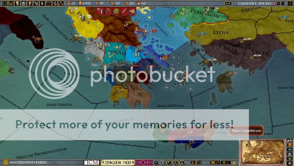
Screenshots of map changes in 1.32. Get it here: http://forum.paradoxplaza.com/forum/showthread.php?t=464453
All populations have been spread across their respective expanded provinces, to keep population in line with vanilla. This may weaken some of the one province minors, like Achaea and Aetolia, but these nations have been given a higher proportion compared to their neighbours.
Province history has also been updated, to show the ebbs and flows of the respective nations throught the time period of the game. Some tweaking may still be required but there shouldnt be any significant historical anomalies. Click foward in the time period and see the Achaen League dominating the Peloponnese or Rhodes at its peak spanning from Crete to Asia Minor.
Greece and Crete:
1)The Peloponnese has been split into the major regions of ancient times. After the defeats of Sparta by Thebes and Macedon throughout the 4th century BC, it is crippled without its control of Messenia. After being a battleground for the Diadochi, tyrants now abound throughout the Peloponnese and the fledgling Achaen League lies hidden along the Corinithian Gulf.
2)Crete has been broken down into four powers to try and represent the disjointed state of affairs on the island in the Hellenic era (and throughout ancient times).
3)Macedon suffers as Antigonus Gonates and Ptolemy Keranous battle it out for the throne. Gonates hanging onto the slim pickings left over from his grandfather and father, has control of the "Fetters of Greece", Demtrias, Etreria and Corinth.
4) The Aegean is dominated by the Ptolemiac Kingdom. They have control of the Dodacense Island chain and indirectly control the Cyclades through the Nesiotic League.
Sicily and Rhegium:
1) Former mercenaries of Agathocles, the tyrant king of Sicily, the Marmertimes massacred the males of Messene and set themsleves up as rulers under their leader Kion.
2) After being defeated by the Carthaginians, Hicetas the ruler of Syracuse is not under attack from within by his rival Theonon and without from Sosistratos the tyrant of Akragas (ruler of thirty towns). Sensing weakness the Cartahginians are on the warpath and attempting to crush the greeks once and for all.
3) At the toe of Italy, Decius a Campnain legionary commander, has rebelled from Rome and following the lead of the Marmertines across the straits, massacred the male population of Rhegium and set himself up as tyrant.

Norhern Greece, Thracia and Bosphorus:
1) After the ruthless and bloody takeover of Macedon by Ptolemy Keraunos, Apollodorus of Cassandria has declared himself tyrant in Chalcidace
2) A huge band of gauls have appeared in the north, poised to descend on greece and barbarians threaten Lysmachia in the Chersonesus.
3) After suffering under tyrants and kings for many years, the city of Hereclia Pontica in the Black Sea has become independent and united with Chalcedon. They have formed a "Northern Alliance" with the people of Byzantium.

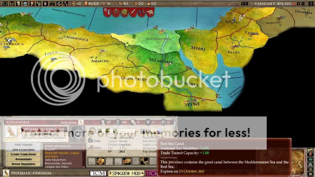
Red Sea and the Canal of Darius modifier:
1) Sorry my Suez Canal is no longer working. I developed it well over a year ago but something has changed in the game mechanics which is stopping it. So no "transferring" ships between the Red Sea and the Mediterranean Sea
474AUC country starting map:

is it possible to take provinces from this mod and put them directly into other mods and if so how?
I think if you take the relevant files (map, region codes, maybe cultures, ect.) a copy would be rather easy. Then, edit from there to what your needs are. This is all of course with the creators approval which I can't give you.
Then you have to add all of the history files, some of which won't work unless you copy over the culture files as well.I think if you take the relevant files (map, region codes, maybe cultures, ect.) a copy would be rather easy. Then, edit from there to what your needs are. This is all of course with the creators approval which I can't give you.
By which point you may as well be playing Epigoni
is it possible to take provinces from this mod and put them directly into other mods and if so how?
As the other guys said, there is a bit of work involved in doing this. Have a look at Cheexsta's excellent thread on map modding in the main User Modifications area. Also if you are thinking of combining it with Magna Terra, you would have to shrink down the mapwork I have done. This would make lots of the provinces I have created to small to playable.
Sounds great, I'm looking forward to giving it a play
Thanks Woody
Great! I just bough the game, and i must say your mod is the best of them.
Cheers mate.
Dont discount the other mods, they are all good.Completed:
1) Clear away Aral Sea terrain
2) Attempt to realign terrain map to topography
3) Add Tochari/Saka invasion events (ala beefed up version of old Parthia event)
This is my to do list:
1) Re-check population and cultures
2) Fix Asian/Tochari culture
3) Test
4) Possibly "crack" the graphicalculture files for asian and indian
The Indus delta has been added and terrain alignment to topography improved. Also a preview of some possible future additions to the map (2565 x 1480):
Good news. I have the 2565 x 1480 map stable and fully operational. This included altering all of the y co-ordinates for every land and sea province in the game. A mammoth task which was made easier by using Excel.
Now the work begins on the part of India that fits into the map. I have put in 10 new test provinces and note the new minimap in the bottom right hand corner:

What does everyone think of connecting the Red Sea/Indian Ocean to the
Mediterranean Sea, via the Canal of Darius ?
I would make the Nile and the canal into three sea provinces. Every nation would be able to use the canal unhindered. This is an example of what it might look like but it can be made to look better:

I have the 2565 x 1480 map stable and fully operational. This included altering all of the y co-ordinates for every land and sea province in the game. A mammoth task which was made easier by using Excel.Now the work begins on the part of India that fits into the map. I have put in 10 new test provinces and note the new minimap in the bottom right hand corner:
What does everyone think of connecting the Red Sea/Indian Ocean to the
Mediterranean Sea, via the Canal of Darius ?
I would make the Nile and the canal into three sea provinces. Every nation would be able to use the canal unhindered. This is an example of what it might look like but it can be made to look better: