• We have updated our Community Code of Conduct. Please read through the new rules for the forum that are an integral part of Paradox Interactive’s User Agreement.

CK2 Dev Diary #78 - Polishing up the Map

Greetings!

We’re working away, and we’ve been working away for quite some time now - it’s just much too early to go into detail on what we’re doing yet, but rest assured that we have a lot of interesting stuff going on!

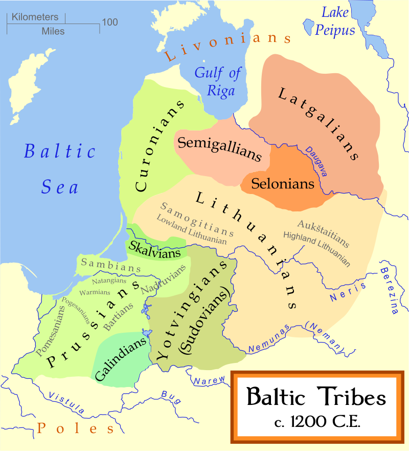
Without spoiling the theme of the upcoming expansion, we want to give you something to look at and discuss. In addition to all the theme-specific features we’re making, we’re also slowly working our way through some of the more neglected areas of the map, correcting mistakes and increasing the granularity of the playing field. Here’s one such area, Poland:
Poland_update.png

Code:
- Map Update to Poland
    - General overhaul to the De Jure territory of the Kingdom of Poland
    - Vistula (major) river tweaked to be more geographically accurate
    - (Minor) river Oder tweaked for more geographical accuracy
    - (Minor) rivers Warta and Bug added
    - 6 new provinces, mostly improving granularity in Mazovia and Lesser Poland
    - All old provinces moved and reshaped for more consistency
    - Some updated provincial Coats of Arms

Later this spring (date yet TBD) we’ll release a bug-fixing patch, so remember to head over to the bug forums and report any issues you find.

Please note that the time between Dev Diaries will be irregular, as we’re very early in the development cycle.
 
This:
But, you don't really need a historically accurate map to see that Hradec Králové is not a part of Moravia, or Znojmo is a part of Austria. Or the fact that the map looks terrible in its current state. @Arthur

Speaking of Znojmo, the town of Ivančice is twice there, once as Ivančice, and once as german eibenshitz, instead just using dynamic name system. The german name seems to misspelled too.
There is plenty of such cases in the whole slavic/WE region.
 
A bit harsh, don't you think?

No.

It takes few minutes to check such things. If somebody is not capable of checking it or too lazy to it, then such person shouldn't do it, and especially take money for it. This game pretends to be as much historically accurate as possible, yet has blatant mistakes and errors. For such price of game and it's dlcs we can except much better quality and accuracy.
 
I found this if it helps you. This one is really detailed and from 11/12th century. I think Leitmeritz/Litomerice is too big, Prague small and Elbe/Labe too South so it makes Leitmeritz bigger.
@[Arthur-PDX]

Cool, thanks ! Saved that map, and I'll see if I can do some quick readjustments to the zone at some point


Arthur
 
The biggest issue with the Bavaria-Austria region atm is that quite a few names are really misplaced. Carinthia (province) and Klagenfurt (barony) definitely were never located in Celje for example. I will try to find some maps and references for that area @Arthur
 
I found this if it helps you. This one is really detailed and from 11/12th century. I think Leitmeritz/Litomerice is too big, Prague small and Elbe/Labe too South so it makes Leitmeritz bigger.
@[Arthur-PDX]
Well, I made this one. It's actually a worse of my old two maps of Bohemia and Poland based on 11/12th century castellanies: http://rome.webz.cz/bohemia_poland.htm

I think this one is much better:
Pol-Boh_jm2.GIF

It's actually hard to get the division of Medieval Bohemia and Moravia into smaller pieces right, since all available sources show only the administrative centers (castellanies) and not the borders themselves. This map tries to do what academic sources don't and can't since they need to be precise, while this is just a projection which takes the forests and other hardcore features like terrain and rivers into account.

That's why Litoměřice is smaller than one would expect, beause it is in the middle of densely populated area with plenty castellanies around.
@Arthur-PDS you can always contact me. I have plenty maps. Unfortunately not all of them in digital form.
 
Last edited:
Cool, thanks ! Saved that map, and I'll see if I can do some quick readjustments to the zone at some point


Arthur
Is there perhaps any chance, you'll share the result with us? (I mean before the release of the patch)
 
@rageair

Nice Poland. :)

France and Germany in particular could do with some tidying up and new provinces; a number of important counties are missing, including several that have families already in-game but currently unlanded.

In our own personal mod, myself and @Prinz Wilhelm have so far added Dreux, Meaux, Ponthieu, Courtenay and Rethel in France, and minimal character additions were required for those.

I think that Wales is really in need of expansion as well, but of course it's a small area to work with. Again, a lot of the families who are missing their counties are already in-game.

If you're interested, throw me a PM and I'll send you what we have. It's not too much to add.
 
@[Arthur-PDX] Could you split Kexholm into Vyborg and Kexholm? In 1323 Sweden and Novgorod set their borders in Finland. Here's what it looks like:
sw1323.gif

c5fce80f3b5ec092ded77850ec1aecc1.jpg

250px-Border_changes_in_Finland_1595.jpg

imatran-yleisesittely-11-638.jpg

Perhaps you could add the province of Oulu/Northern Ostrobothnia as Swedes didn't own that are yet in CK2 time-frame. The province would remain Pagan for the entire timeframe and also have a Sami majority until the end of the game. Technically you could redraw all the Finnish provinces based on this border, IDK :p.
 
I would consider renaming Czersk to Rawa, as "ziemia czerska" was on both sides of the Vistula river, and "ziemia rawska" was only on the west side. Also, later on (1462+) Rawa was a capital of a voivodship, and Czersk was just a part of Masovian voivodship.

Mazowsze1313.png
 
Also Estonia could do some rework, pretty much every province on the map below was an independent nation until the Livonian order ate them all up, except IIRC Vaiga was dependent on Ugandi and Läänemaa might have been under the rule of Saaremaa.
2000px-Ancient_Estonian_counties.svg.png

Selonia could be added on the map with the count tier tribe of Selonia. And the Livonian Coast too with under the rule of Livonians:
800px-Baltic_Tribes_c_1200.svg.png

livciltis.jpg

image005.jpg

So there's that. Ps. If anyone is bothered by the sizes of these images on the thread, I can replace them with links. Now, Slime away!

(...I think I can hear es333 somewhere...)
 
Just because they rework poland doesn't mean they make slaves DLC or something related to the region.

When they reworked Hungary they made M&M (I think) and there was no special relation to that region.
 
I'm particularly happy about changing the old misplaced Upper/Lower Silesia provinces. The new map looks great!

Edit: I can't decipher this in the screenshot: what is the name of westernmost Silesian province?
 
You guys are the best. Specially if u would put some more attention please to Livonia. It definitely should be separate kingdom with more provinces since that area is very rich and good land. Just look trough out history.