• We have updated our Community Code of Conduct. Please read through the new rules for the forum that are an integral part of Paradox Interactive’s User Agreement.
Earl Uhtred said:
Meh. Good for Tweeddale maybe but you still have to cross the Pentlands. Oh well, your tickle your rules.

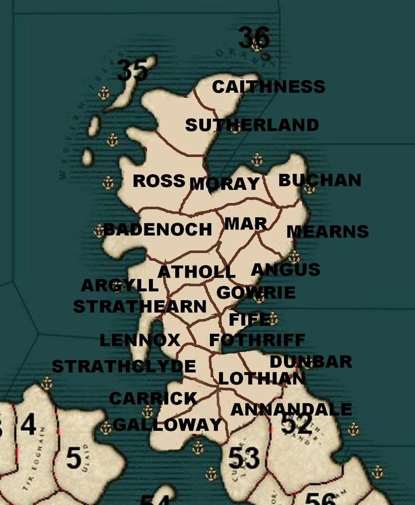
That's no biggie. We're not talking the Himalayas here, Dere Street goes right through the hills. There are hills likes that everywhere in Scotland. Dunbar has the same issue (the route through Cockburnspath being its Dere Street), as do most Scottish provinces however you do 'em. Anyways, I don't understand, the area is mostly hills except for the royal burghs of Edinburgh (far north) and Roxburgh (far south), is all royal demesne, so is functionally unimportant in this game in terms of titles, performing the function of being between Scotland-proper and England-proper. There are two major lordships in the south-east area, the king's and the earl's, the former in the west (Teviot/Tweedale and West/Central Lothian-proper) and the east (the rump of the Bernician earldom). So, what can I say. But, listen man, this is no big deal to me ... any improvement to the Scotland map he makes will be appreciated by me ... anything being better than nothing. ;)
 
scotmap02.jpg


I think we need to trust in Kurek instincts in map making. With respect Calgacus, I tend to agree with Earl Uhtred regarding Lothian. But for me it is more based on an aesthetical point of view. Dispite the road, it seems to me that Dunbar and Annandale should share a common border too.

Also, for me, the point where Strathclyde, Carrick, Galloway, Annandale, and Lothian connect at a single point seems glaringly artificial. Prehaps they did meet here, but it looks very odd to me.

I think we need to let Kurek look at a map and make his own judgement, and trust in this. He did a FANTASTIC job on Wales, which could have been the most difficult, and a great job in Ireland. Let us give him input, but trust in his aesthetic sensability. If there is something that needs to be tweeked, he will gladly do this, as he did with Wales on a minor border tweek that had made a HUGE difference for Gwynedd.
 
Last edited:
Drachenfire said:
Also, for me, the point where Strathclyde, Carrick, Galloway, Annandale, and Lothian connect at a single point seems glaringly artificial. Prehaps they did meet here, but it looks very odd to me.

Drachen, I didn't post that map intending him to copy it, more to show how the provinces I thought best could fit into the map. Regarding the meeting point of Strathclyde et al., yes. Annandale should, as it does, run into Strathclyde, with Galloway-Carrick to the West. The problem I had when doing it was however that the area south of the Forth is made smaller than it really is by the game skewed map. Galloway itself is more than a third of this area, but can never be so on this map. I would probably doubt that Kurek would include Annandale anyway, as he'll see the same problem.

Drachenfire said:
I think we need to trust in Kurek instincts in map making. With respect Calgacus, I tend to agree with Earl Uhtred regarding Lothian. But for me it is more based on an aesthetical point of view. Dispite the road, it seems to me that Dunbar and Annandale should share a common border too.

Well, for me inaccuracy is ugly and accuracy beautiful. :D I posted those maps above to make the historical basis of the map I drew transparent and for Kurek to be better informed when using his own judgment. But you'll see here, from this map, that the one I posted is accurate ... i.e. the "Lothian" royal demesne lands cut a huge path between Dunbar earldom and Annandale lordship, a path larger than those two lordships combined (though the Dunbar earldom is admittedly originally larger than that depicted).

mormaer03.jpg
 
I prefer accuracy as well, but usually most borders in Europe follow geographic features is what I was getting at before, which look more natural then the meeting point I mentined above.

If the white in the Scottish map above represents the Royal Demise, then prehaps Lothian could still be split somehow? What was the region between Dunbar and Annandale known as? If it could be broken up. Kurek can possibly enlarge the map within reason. Was there any other important barony in this region?

For the Perfeddwald in 1337, there was no single overlord to assign as Earl/Count. So instead I assigned the powerful barony Grey de Ruthyn based in Rhuddlan Castle as the rulers of Perfeddwald, as Count of Prefeddwald for the game. Prehaps a simular accomindation can be found to assign a ruler to that region to break Lothian up.

Edit:

Prehaps it would be best to simply let the region represent Annandale, shift Annandale to the region in Question and let Galloway remain the size that it is currently.
 
Last edited:
Drachenfire said:
I prefer accuracy as well, but usually most borders in Europe follow geographic features is what I was getting at before, which look more natural then the meeting point I mentined above.

The map I did corresponds with physical boundaries quite well, the hills Uhtred mentioned are effectively by-passed by the "Via Regia", i.e. Dere Street, and are just one block of hills in an area dominated by them. This is sheep-raising country after all.

See for yourself:

http://maps.google.co.uk/maps?q=Goo...35748,-2.705383&spn=0.742592,2.732849&t=h&z=9

Drachenfire said:
If the white in the Scottish map above represents the Royal Demise, then prehaps Lothian could still be split somehow? What was the region between Dunbar and Annandale known as? If it could be broken up. Kurek can possibly enlarge the map within reason. Was there any other important barony in this region?

The closest thing would be Teviotdale, only because the archdeaconry of Teviotdale (a sub-unit of the bishopric of Glasgow) covers much of the area, though Teviotdale itself is just one of many straths/dales in the area, Upper Tweeddale being another. Most of the land that wasn't a giant forest, was pasture country essentially granted out to monasteries by the king, who collected the fruits from his cities at Roxburgh, Berwick and Edinburgh, as Flemings carted them off to Europe.

Drachenfire said:
For the Perfeddwald in 1337, there was no single overlord to assign as Earl/Count. So instead I assigned the powerful barony Grey de Ruthyn based in Rhuddlan Castle as the rulers of Perfeddwald, as Count of Prefeddwald for the game. Prehaps a simular accomindation can be found to assign a ruler to that region to break Lothian up.

Edit:

Prehaps it would be best to simply let the region represent Annandale, shift Annandale to the region in Question and let Galloway remain the size that it is currently.

I'm all for more provinces, but I fear the number of new provinces for Scotland will be limited. That area is really small, esp. as depicted in the CK map.

But just to repeat, this is no big deal to me. If Kurek wants to follow Uhtred's succession, then it's not biggie ... not gonna keep me up. Just pointing out its historical faults. Honestly, I care more about the area north of the Forth.
 
A small issue with movement from the British Isles to the Middel East

When you now move an army from Ireland to say Antioch, you take a trip over the Atlantic ocean. Since that is now the shortest route

seatrip.jpg
 
Them Irish monks sure like to sail around. Probably off to settle the new world and whatnot.

I guess I should play around a lot with the seazone ID's or something to make it make more sense sailing wise. I've not touched anything with maps for a while now, been mostly drinking away all my money but alas that has dried up so boredom will settle in and I might have another bash at the mapping and see about Scotland. (might not though, depends if I get enough money soon to resume my semi alcoholism and break through my spell of severe procrastination
rar.png
)

Oh and also in my version of the files I set up a new dynasty and character to be count of An Cabhan but the dynasty name is not showing up in game. Just shows his first name and when he has a child the game crashes. Anyone know why? Here's the relevant lines in the code:

Code:
character = {
	id = { type = 10 id = 50000 }
	name = "Olchobar"
	gender = male
	dynasty = { type 12 id = 200100 }
	country = c871
	religion = catholic
	culture = irish
	score = { gold = 25 prestige = 100 piety = 100 }
	birthdate = { year = 1036 month = may day = 1 }
	dna = "04060410020313"
	attributes = {
		martial = 5
		diplomacy = 6
		intrigue = 6
		stewardship = 6
		health = 5
		fertility = 8
	}
	traits = {				
    charismatic_negotiator = yes
	}
}

And in Dynasties.txt

Code:
dynasty = {
  id  = { type 12 id = 200100 }
  name = "Ó Raghallaigh"
  province = { }
}

Probably some stupid minor newb mistake but I'm terrible at this sort of stuff. :eek:o

Thanks to the person who will immediately point out my mistake thus shaming me for newbosity and whatnot.
 
This

Code:
character = {
	id = { type = 10 id = 50000 }
	name = "Olchobar"
	gender = male
	dynasty = { type 12 id = 200100 }
	country = c871
	religion = catholic
	culture = irish

And this

Code:
dynasty = {
  id  = { type 12 id = 200100 }
  name = "Ó Raghallaigh"
  province = { }
}


should be this

Code:
character = {
	id = { type = 10 id = 50000 }
	name = "Olchobar"
	gender = male
	dynasty = { type [COLOR=Lime][B]= 12 [/B][/COLOR]id = 200100 }
	country = c871
	religion = catholic
	culture = irish

and this

Code:
dynasty = {
  id  = { type [COLOR=Lime][B]= 12[/B][/COLOR] id = 200100 }
  name = "Ó Raghallaigh"
  province = { }
}

You forgot the = after 'type' :)

BTW, I have used this character to rule An Cabhan, he is the (arch)bishop of Armagh. And Armagh seems to be in that province

Code:
character = {
	id = { type = 10 id = 926 }
	name = "Mael-Isu"
	gender = male
	dynasty = { type = 12 id =553 }
	country = C871
	religion = catholic
	culture = Irish
	score = { gold = 50 prestige = 100 piety = 100 }
	birthdate = { year = 1031 month = january day = 1 }
	deathdate = { year = 1078 month = january day = 1 }
	dna = "05630566631131"
	attributes = {
		martial = 5
		diplomacy = 5
		intrigue = 5
		stewardship = 5
		health = 5
		fertility = 7
	}
	traits = {
		scholarly_theologian = yes
	}
}
 
Veldmaarschalk said:
BTW, I have used this character to rule An Cabhan, he is the (arch)bishop of Armagh. And Armagh seems to be in that province

That would be historically odd, Armagh being more important and not in Cavan. CK-geographically though, An Cabhan province is occupying more important lordships like Oriel/Airgíalla and Armagh, as well as most of co. Cavan. (Probably inaccurate) ruler-lists for Oriel are floating about the web ...

BTW, not that it's a big-deal, but a name like Olchobar Ó Raghallaigh is orthographically inconsistent. Basically, Ó is modern Irish for Ua, and if you have Ó Raghallaigh then the spirantization in Olchobar should be indicated, as Olchobhar.

Likewise Mael Isu would be something like Maol Iosa (ae - > ao).
 
Last edited:
Calgacus said:
That would be historically odd, Armagh being more important and not in Cavan. CK-geographically though, An Cabhan province is occupying more important lordships like Oriel/Airgíalla and Armagh, as well as most of co. Cavan. (Probably inaccurate) ruler-lists for Oriel are floating about the web ...

BTW, not that it's a big-deal, but a name like Olchobar Ó Raghallaigh is orthographically inconsistent. Basically, Ó is modern Irish for Ua, and if you have Ó Raghallaigh then the spirantization in Olchobar should be indicated, as Olchobhar.

Likewise Mael Isu would be something like Maol Iosa (ae - > ao).

The name itself was mainly confined to Munster, some outside had it (I think at least one O'Brien chief of the Aran islands had the name). In Munster, there was an Olchobar mac Cinaeda. An abbot is also known of by the name Olchobar or Olchobhor, depending on the source. I would use Olchobhor, but I just prefer how it looks. There are many spellings of the name though.
 
Barón Rojo said:
I can't download it!

Filefront removes files when they haven't been downloaded for a while and when the owner doesn't confirm that he wants to keep it

There are two mods out that use this map

DVIP Wales, which AFAIK only has the Welsh provinces added

Before the conquest, which has the extra Welsh and Irish provinces
 
Rob de Hard said:
Won't adding so many provinces to the British region give the monarchs a massive boost in troops and income?

Depends on the income of those provinces. If the total income stays (almost) the same then there is no real problem.
 
Here's a crazy thought. How about ditching the rest of the world and just blowing up the British Isles, maybe with northern France? That was the first thing I thought of when I opened this thread. :)
 
Barahir said:
Here's a crazy thought. How about ditching the rest of the world and just blowing up the British Isles, maybe with northern France? That was the first thing I thought of when I opened this thread. :)

This is possible and has been discussed between myself and Kurek. A viking-period map would be fun, with Norwegians and Danes appearing similar to Mongols at certain times. Then the Norman invasions, done similarly, that'd be fun. The ability to create the numerous petty kingdoms in the area, and the further ability to gain traits like 'High King of Ireland' or 'High King of Alba' and so on, that'd be present, and cool. But, it'd be plenty of work, and would require a lot of help probably in getting provinces right.
 
Bumping this thread. Curious if Kurek is about, and if he isn't, or isn't willing to continue, understandable, maybe some one else who's technically apt could pick up and continue work here? Seems sad to have stopped before Scotland got sorted, let alone England, and touch ups on Ireland and Wales.
 
Bumping this thread. Curious if Kurek is about, and if he isn't, or isn't willing to continue, understandable, maybe some one else who's technically apt could pick up and continue work here? Seems sad to have stopped before Scotland got sorted, let alone England, and touch ups on Ireland and Wales.

I hope someone does, I'd love to see this expanded for the whole British Isles. I have a few ideas for improving England, but lack the ability to make any kind of functioning map.
 
What'd be really great is if the map was totally redrawn to include only the British Isles. Hundreds of provinces could mean provinces of hundreds! I guess playing the king of England might get a little tedious though, having to put down rebellions every two seconds. :eek: