
New Map - Europa Imperialis (WIP)
- Thread starter Cheexsta
- Start date

-
We have updated our Community Code of Conduct. Please read through the new rules for the forum that are an integral part of Paradox Interactive’s User Agreement.
You are using an out of date browser. It may not display this or other websites correctly.
You should upgrade or use an alternative browser.
You should upgrade or use an alternative browser.
Slowly. Today has been the first day since about a week before Christmas that I've actually been able to chill out at home. The festive season has been very busy, between work and family commitments. However, with the usual post-Christmas slump starting now, I'll have a lot more days off work to get back into it ")
Expect some updates over the next couple of weeks
Expect some updates over the next couple of weeks
I can't wait to hear about the updates! I'm really excited to give this a try when the time comes.
Update time! Who said this project was dead?
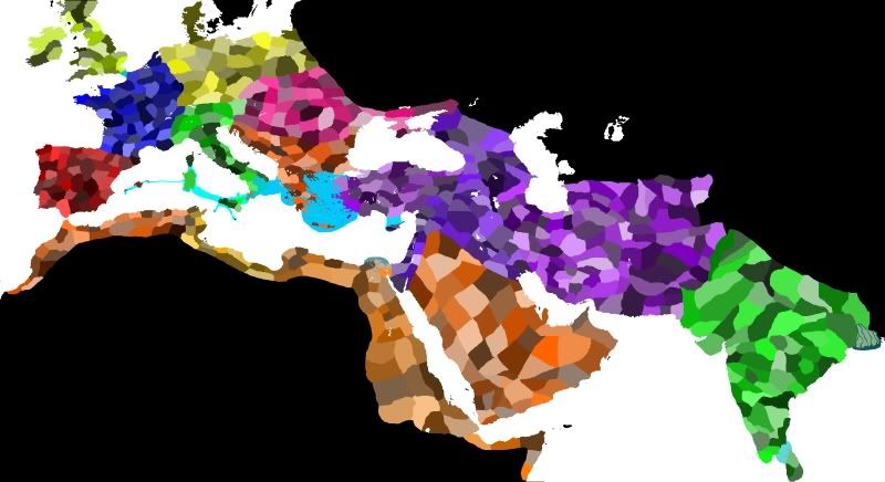
Most of the land provinces are now implemented, and we're currently sitting on 688 land provinces - I haven't even started on sea provinces yet (but those should be relatively easy, as they'd be spaced out according to game balance rather than historical positions).
I still need to go back and fix up some messy borders and make some mock-up historical empires to make sure the borders work more or less universally, so if anyone has any suggestions then I am all ears!
Still to do before the first alpha version is released:
1. Fix province borders (as above) and names.
2. Add sea provinces.
3. Finalise region groupings.
4. Add tradegoods.
5. Add basic history files.
Still a fair bit to do, but I've got the whole week to do this so I should have another update or two within the next week.
Excellent work. I just remembered that I found some brilliant maps of the eastern Persia and western India on the net a while back.
I will see if I can find them for you. They are the best I have seen of this region.
I will see if I can find them for you. They are the best I have seen of this region.
Suggestion: Head a bit north of Transoxania/Bactria and add a few provinces there. Afaik Sogdiana/Ferganha are located there unless I read the map wrong, which would put Alexanria Echate on there as well.
And obviously great work, looking extremely good
And obviously great work, looking extremely good
Marakanda (the Greek name for Samarkhand, the "capital" (for want of a better term) of the Sogdians) is already included in the map. I went as far as I could find cities, but if anyone is able to find better maps of the region then it would be greatly appreciated!Suggestion: Head a bit north of Transoxania/Bactria and add a few provinces there. Afaik Sogdiana/Ferganha are located there unless I read the map wrong, which would put Alexanria Echate on there as well.
And obviously great work, looking extremely good
Thanks everyone
This week is proving a little busy, but I'll try to get an update going by Monday.http://en.wikipedia.org/wiki/Alexandria_EschateMarakanda (the Greek name for Samarkhand, the "capital" (for want of a better term) of the Sogdians) is already included in the map. I went as far as I could find cities, but if anyone is able to find better maps of the region then it would be greatly appreciated!
Thanks everyone
That's the city I am refering to, but it's very hard to see where your map ends without rivers/cities for localisation. Does the map reach the Jaxartes river? If it does you will most like already have incorporated the Ferganha province and there's no more to say on the matter
Also, another suggestion: What about having uncolonizable (say that events forbid these provinces to ever drop below 2 Barbarian Pops/nearby provinces never cross 50 Civ rating) provinces on the fringes to the steppes of Asia? These provinces could, when the time is right, be transfered to tribes that invaded during those times, such as the Sakae, Yuezhi and Pahlavi/Parni/Parthians (or whatever they were actually called). Just an idea, name sfor those provinces could probably use the same principle as the central European provinces in vanilla are done, by the names of the tribes that lived there.
Ah, yes, I've included Alexandria Eschate on the map alreadyhttp://en.wikipedia.org/wiki/Alexandria_Eschate
That's the city I am refering to, but it's very hard to see where your map ends without rivers/cities for localisation. Does the map reach the Jaxartes river? If it does you will most like already have incorporated the Ferganha province and there's no more to say on the matter
It's the province on the furthest northeastern tip of the map! That's assuming I got the positions of the rivers correct; I know I've made a few mistakes with the Oxus and Ochus, for example.I actually had the thought of including uncolonisable provinces on the fringes of the map, purely for aesthetic reasons, but it's an interesting idea to tie it into tribal invasions. Definite food for thought.Also, another suggestion: What about having uncolonizable (say that events forbid these provinces to ever drop below 2 Barbarian Pops/nearby provinces never cross 50 Civ rating) provinces on the fringes to the steppes of Asia? These provinces could, when the time is right, be transfered to tribes that invaded during those times, such as the Sakae, Yuezhi and Pahlavi/Parni/Parthians (or whatever they were actually called). Just an idea, name sfor those provinces could probably use the same principle as the central European provinces in vanilla are done, by the names of the tribes that lived there.
This is the map I was referring to: http://beroma.users.photofile.ru/photo/beroma/96077139/115861498.jpg. Based on the description, I think it refers to Alexander's conquests. A different/similar version of this map was used as the background of the the EUR PDF manual. I purchased a copy of "The Landmark Arrian - The Campaigns of Alexander" about six months ago and on the jacket was a similar map. From this I was able to track it down. :laugh:
It comes from this website which has many other maps which I havent examined yet: http://oko-planet.su/history/historydiscussions/page,6,62625-starinnye-karty.html
I hope it helps, map material on this area is rare.
It comes from this website which has many other maps which I havent examined yet: http://oko-planet.su/history/historydiscussions/page,6,62625-starinnye-karty.html
I hope it helps, map material on this area is rare.
wow amazing map! I think the only really debatable issue is the position of "Oxia" ( I assume Alexandria Oxiana)? Which is now commonly identified with Ai Khanoum in Afghanistan (that would be east of Aornos on the Oxus (in what the map calls "Bubacene"), rather than in Sogdiana.
From the same site Hardradi gave, this map is also very good, it gives the position of Oxiana in Ai Khanoum, the bactrian city of Drapsaca and other things (It doesn't have the Aral sea though, it is still debated weather the Aral sea existed at the time though)
http://beroma.users.photofile.ru/photo/beroma/96077139/115861527.jpg
Last edited:
Salvete! Sorry it has been so long since I have updated this project; rest assured that it is still being worked on! I've unfortunately had less time than I had anticipated, and my computer has been commandeered a number of times by my better half for purposes of Skyrim...
I'm currently hammering out some CTDs I've been experiencing, and will be revisiting the Oxus region. There's still a ways to go before this is in a releasable state, but I promise to keep more on top of it
Thanks to everyone for the feedback!
I'm currently hammering out some CTDs I've been experiencing, and will be revisiting the Oxus region. There's still a ways to go before this is in a releasable state, but I promise to keep more on top of it
Thanks to everyone for the feedback!
Great to see this one still alive!
Have you populated the map more than the one province at all or is it just blank at the moment?
Have you populated the map more than the one province at all or is it just blank at the moment?
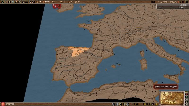
The provinces are still empty at the moment. I'm working on improving the Central Asia zone before getting to that
Now, onto the Oxian issue. It looks like in making this map, I misplaced a couple of rivers and so will be revisiting the whole region. The first task is to actually place the rivers properly, which leads to the first problem: the position of the Oxus. It currently flows into the Aral sea, just to the east of the Caspian, but this was not always the case. I haven't been able to read the book yet, but according to that page, Herzfeld concludes that the Oxus flowed into the Caspian Sea at start of our period. This is consistent with the map Hardradi found (VERY nice find, by the way!).
The main problem so far has been in finding consistent and reliable maps of the area prior to the major Soviet works in redirecting the rivers in the area for local irrigation in the '60s, but the best lead I have so far is this map from a scientific paper, which gives a nice outline of where the rivers used to run.
Using that map as a guide, I've worked out the following:
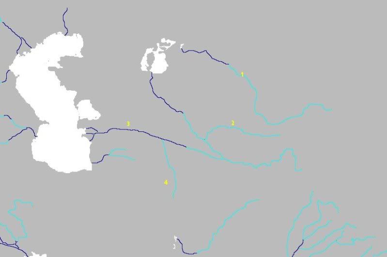
1 - Iaxartes River (modern Syr Darya). Alexandria Eschate will be placed near the south of the river.
2 - Polytimetos River (modern Zeravshan River). Samarkand/Marakanda will be placed near it.
3 - Oxus River (modern Amu Darya). You'll see that it flows both into the Caspian and the Aral (in game terms there will be a tiny gap, simply because of engine limitations); it apparently managed to change its flow several times over history, and at some point drained into both seas simultaneously. I figure it's safest to represent both possibilities, since sources don't seem to be consistent about it.
Ignore (4), it was meant to represent the Ochus but I'm not completely sold on its location.
Edit: it's also worth noting that the Aral Sea at the time would have been much larger, but I don't intend on changing it as the map probably won't extend quite that far.
Next step: to clean up the provinces in the area
Now, onto the Oxian issue. It looks like in making this map, I misplaced a couple of rivers and so will be revisiting the whole region. The first task is to actually place the rivers properly, which leads to the first problem: the position of the Oxus. It currently flows into the Aral sea, just to the east of the Caspian, but this was not always the case. I haven't been able to read the book yet, but according to that page, Herzfeld concludes that the Oxus flowed into the Caspian Sea at start of our period. This is consistent with the map Hardradi found (VERY nice find, by the way!).
The main problem so far has been in finding consistent and reliable maps of the area prior to the major Soviet works in redirecting the rivers in the area for local irrigation in the '60s, but the best lead I have so far is this map from a scientific paper, which gives a nice outline of where the rivers used to run.
Using that map as a guide, I've worked out the following:
1 - Iaxartes River (modern Syr Darya). Alexandria Eschate will be placed near the south of the river.
2 - Polytimetos River (modern Zeravshan River). Samarkand/Marakanda will be placed near it.
3 - Oxus River (modern Amu Darya). You'll see that it flows both into the Caspian and the Aral (in game terms there will be a tiny gap, simply because of engine limitations); it apparently managed to change its flow several times over history, and at some point drained into both seas simultaneously. I figure it's safest to represent both possibilities, since sources don't seem to be consistent about it.
Ignore (4), it was meant to represent the Ochus but I'm not completely sold on its location.
Edit: it's also worth noting that the Aral Sea at the time would have been much larger, but I don't intend on changing it as the map probably won't extend quite that far.
Next step: to clean up the provinces in the area
The more I look at it, the less I like it. Almost every map I see has the Oxus in a different position from the one before it, so it really looks like there's no consensus about the layout of this region. Plus, the one map I based my rendition on is the only one I could find to support it.
I'm thinking of simply removing the western section of "my" Oxus - it would have barely stood within the boundaries of the map's provinces, anyway. The other rivers, the Iaxartes and Polymetos, are more important in defining the boundaries of the edge of the map.
Any input in this matter will be greatly appreciated
The more I look at it, the less I like it. Almost every map I see has the Oxus in a different position from the one before it, so it really looks like there's no consensus about the layout of this region. Plus, the one map I based my rendition on is the only one I could find to support it.
I'm thinking of simply removing the western section of "my" Oxus - it would have barely stood within the boundaries of the map's provinces, anyway. The other rivers, the Iaxartes and Polymetos, are more important in defining the boundaries of the edge of the map.
Any input in this matter will be greatly appreciated
very nice rivers
I think you should choose one of the two options for the Oxus, whether it flows into the Aral or the Caspian seas, both choices are valid I believe. However I think the Oxus flowing into the Caspian would still reach Chorasmia, and from there it would go west through the Ustyurt Plateu. That at least was the position of the Oxus when it was flowing through Konya Urgench without the Oxus probably a civilization in Chorasmia never existed?
As for the Ochus, i think the position is right? The Ochus should flow through Antiochia Margiana if I am not mistaken.
Could I urge you to take a look at the map used by the Europa Barbarorum modders for Rome Total War? As far as I am aware they have access to some of the most extensive libraries of information on the period, being a group of researchers, proffessors and archaelogists and so on. If someone got the rivers right it would be them.
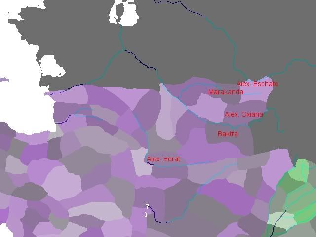
Thanks for the feedback, guys I've looked into the EB map, looks like they've also decided to go for the "split Oxus" route but the river passes through further north. I think I'll go with that idea, as I've now seen it repeated on a few maps. Here is what I have now, with the river map overlaid and some key provinces labelled. I'm MUCH more satisfied with this one, now I'm just considering adding more steppe provinces to provide some barbarian harassment to the Seleucids' northern border.
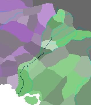
And, while I was at it, I decided to revisit the Indus region and added a few cities that are mentioned in Alexander's campaigns. Still some work to do, but the India zone is more or less ready.
I've looked into the EB map, looks like they've also decided to go for the "split Oxus" route but the river passes through further north. I think I'll go with that idea, as I've now seen it repeated on a few maps. Here is what I have now, with the river map overlaid and some key provinces labelled. I'm MUCH more satisfied with this one, now I'm just considering adding more steppe provinces to provide some barbarian harassment to the Seleucids' northern border.
And, while I was at it, I decided to revisit the Indus region and added a few cities that are mentioned in Alexander's campaigns. Still some work to do, but the India zone is more or less ready.
Another minor update, I've started nutting out a basic idea for the terrain view. At the moment, I'm leaning towards this antiquated map style:
The finished product would have much more textural detail, of course. I'm also thinking of making the map different colours for different "zones" (Iberia, Gallia, Italia, etc.) and adding labels for them.
Also, I'm still having the problem where most of my provinces aren't displaying their positions.txt changes at all. Does anyone know why this is happening?
Edit: found it! Turns out the problem was twofold: firstly, the game doesn't like the trade entry, so deleting that fixed half the problem; the other issue was that the game seems to prefer everything in positions.txt in a specific order. If anyone else has a problem with the Positions Editor, make sure you edit position_types.txt (in the same folder as the editor) so the Rome section reads like this:
Code:
rome = {
	display = "Rome"
	map_inverted = no
	has_sea_list = no
	land = {
		city=xy
		city_nudge=nudge
		unit=xy
		port=xy
		port_rotation=rotation
		siege=xy
		siege_nudge=nudge
		manufactory=xy
		text_position=xy
		text_rotation=rotation
		text_scale=scale
	}
	sea = {
		unit = xy
		siege = xy
		siege_nudge = nudge
		text_position = xy
		text_rotation = rotation
		text_scale = scale
	}
}
Last edited: