
Mexbuild's Worldmap - Info & Updates
- Thread starter Mexbuild
- Start date

-
We have updated our Community Code of Conduct. Please read through the new rules for the forum that are an integral part of Paradox Interactive’s User Agreement.
You are using an out of date browser. It may not display this or other websites correctly.
You should upgrade or use an alternative browser.
You should upgrade or use an alternative browser.
You can still vote for your favorite font but now another question.
How I should handle large rivers like the Amazonas?
Do you only want a river layer like in vanilla or do you want a single "sea province" so you get penalities for amphibious attacks?
How I should handle large rivers like the Amazonas?
Do you only want a river layer like in vanilla or do you want a single "sea province" so you get penalities for amphibious attacks?
You can still vote for your favorite font but now another question.
How I should handle large rivers like the Amazonas?
Do you only want a river layer like in vanilla or do you want a single "sea province" so you get penalities for amphibious attacks?
the Sea Province Idea sounds better
")
You can still vote for your favorite font but now another question.
How I should handle large rivers like the Amazonas?
Do you only want a river layer like in vanilla or do you want a single "sea province" so you get penalities for amphibious attacks?
The Amazon and some others large rivers is more like a long lake than a actual river, so I vote for the latter.
Here you cann see some of South America. Now I am working on Ahmadinedschadistan and Binladistan. :rofl:


Now you are pleased to comment: Is that okay how I make the borders? Or do you have another map or better ideas?

Nice one, when ca. are you planning on releasing this?
Won't this mod require much more computer performance? Im affraid my comp couldnt run this amazing mod
And one more thing, have you finished the map of Iceland? If so can you post a screen of that please?
Won't this mod require much more computer performance? Im affraid my comp couldnt run this amazing mod
And one more thing, have you finished the map of Iceland? If so can you post a screen of that please?

Won't this mod require much more computer performance? Im affraid my comp couldnt run this amazing mod
Wjy should it? It is just a different 2D background.
This is outstanding work! Very high praises are in order.
A few nitpicks for the map of Estonia.
The prewar and current map have changed somewhat and in a way that this cannot be transformed into HOI or AoD scale. However I suggest that you split thet big province in estonia horisontally.
Here is my two cents to help you (sorry for my lousy paint skills).
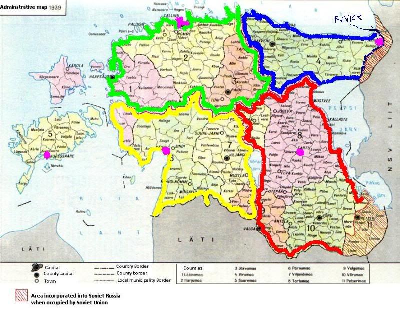
The Green area should be province called "Tallinn" in game terms (the location of the city spot is purple).
The Blue area should be province called "Virumaa" or "Narva" and if it has a city centre it should be "Narva".
The Red area be province called "Tartu", city of Tartu is again designated by purple color.
The Yellow area be province called "Pärnu" (or Parnu), city of Pärnu is again designated by purple color.
I would suggest the islands to constitute a fift province, but if this is not a great idea)) then give the northern one to "Tallinn" and the Southern one to "Pärnu".
If they are a separate province they could be called "Saaremaa" or "Kuressaare" the location of the town of Kuressaare is purple. If the islans form a separate province they should have a land connection (like sicily to the boot of Italy) to both Tallinn and Pärnu.
Also I used red striping for territories lost to Soviet Russia (and nowadays to Russian Federation after WW2 and the occupation). Just as a piece of information to you. If the map is supposed to be mostly for WW2 time period you could make the map reflect them to be a part of Estonia.
A few nitpicks for the map of Estonia.
The prewar and current map have changed somewhat and in a way that this cannot be transformed into HOI or AoD scale. However I suggest that you split thet big province in estonia horisontally.
Here is my two cents to help you (sorry for my lousy paint skills).
The Green area should be province called "Tallinn" in game terms (the location of the city spot is purple).
The Blue area should be province called "Virumaa" or "Narva" and if it has a city centre it should be "Narva".
The Red area be province called "Tartu", city of Tartu is again designated by purple color.
The Yellow area be province called "Pärnu" (or Parnu), city of Pärnu is again designated by purple color.
I would suggest the islands to constitute a fift province, but if this is not a great idea
)) then give the northern one to "Tallinn" and the Southern one to "Pärnu".If they are a separate province they could be called "Saaremaa" or "Kuressaare" the location of the town of Kuressaare is purple. If the islans form a separate province they should have a land connection (like sicily to the boot of Italy) to both Tallinn and Pärnu.
Also I used red striping for territories lost to Soviet Russia (and nowadays to Russian Federation after WW2 and the occupation). Just as a piece of information to you. If the map is supposed to be mostly for WW2 time period you could make the map reflect them to be a part of Estonia.
Thanks for the ideas Deus. I will pay attention to them.
Now I have started work one one of the most difficult things: China.

Now I have started work one one of the most difficult things: China.

Wjy should it? It is just a different 2D background.
With more provinces, and more for the game to calculate.
Not the initial map as that's just a nicer looking one with the same amount of provinces. Max it's probably going to be double the provinces as more is not needed when it's at the division level.
The Europa engine can handle a lot so I wouldn't worry about too much lag. Hopefully
The Europa engine can handle a lot so I wouldn't worry about too much lag. Hopefully
With more provinces, and more for the game to calculate.
Doesn't anybody read Mex' post?
First: standard map with better looks.
Second: improved map with more provinces
Doesn't anybody read Mex' post?
First: standard map with better looks.
Second: improved map with more provinces
Yes, I have read those. That guy asked if this map project will make the game run slower. When the mod is ready, Mexbuild has done the second part, making the game run slower.
Yes, I have read those. That guy asked if this map project will make the game run slower. When the mod is ready, Mexbuild has done the second part, making the game run slower.
Sorry, got that one wrong.
Doesn't anybody read Mex' post?
First: standard map with better looks.
Second: improved map with more provinces
With some exceptions. In regions with many claims and/or with a complicated mix of nature and administrative borders will be more provinces than in Vanilla.
If the map runs slower is dependant by the amount of provinces.