
Mexbuild's Worldmap - Info & Updates
- Thread starter Mexbuild
- Start date

-
We have updated our Community Code of Conduct. Please read through the new rules for the forum that are an integral part of Paradox Interactive’s User Agreement.
You are using an out of date browser. It may not display this or other websites correctly.
You should upgrade or use an alternative browser.
You should upgrade or use an alternative browser.
Oh I just noticed a typo on a French Province.
It's Besançon (between Genève and Dijon) not Besacon.
It's Besançon (between Genève and Dijon) not Besacon.
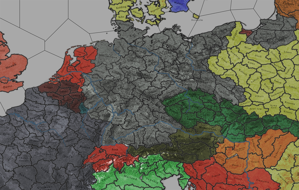
Not a big fan of mini provinces like Bremen and Liechtenstein. It needs to be clickable. Cuxhaven could be Bremen and Liechtenstein should not even be on the map.
This http://www.abload.de/img/screensave17qe31.jpg is it how the maps on the first page look like in-game. Because I would rather see something like your mock-ups in-game. Give AoD a more updated look. Especially the rivers look bad in vanilla. On the mock-ups the rivers look great. Anyway of incorporating that look. And make the borders of provinces (you know where the main color becomes darker) less wide. Would make it look more crisp.
Do you know what the Victoria terrain map looks like? Instead of solid colors representing terrain a more natural look is used.
http://img.gamespot.com/gamespot/images/2003/reviews/914835_20031202_screen001.jpg
Would something like that be possible with AoD?
Looks pretty impressive. Just wondering though how it will work with rivers - it looks like they flow through some provinces, as opposed to the 'only province border' system with the current map. How would that affect movement and combat modifiers?
Not a big fan of mini provinces like Bremen and Liechtenstein. It needs to be clickable. Cuxhaven could be Bremen and Liechtenstein should not even be on the map.
This http://www.abload.de/img/screensave17qe31.jpg is it how the maps on the first page look like in-game...
Do you know what the Victoria terrain map looks like? Instead of solid colors representing terrain a more natural look is used.
http://img.gamespot.com/gamespot/images/2003/reviews/914835_20031202_screen001.jpg
Would something like that be possible with AoD?
No, the screens in the last post are from the former "project new europe" and the pics are more than one year old.
To the Victoria map: Do you mean something like this?

if you could manage to make the seaprovinces as awesome as the landprovinces....
That´s really really good work and you got me hooked with it
That´s really really good work and you got me hooked with it
that looks really frickin' awesome imoTo the Victoria map: Do you mean something like this?
No, the screens in the last post are from the former "project new europe" and the pics are more than one year old.
To the Victoria map: Do you mean something like this?
Mapgasm!
No seriously that is beautiful. If you could pull that off... Can you?
I love how people are criticizing the most minor "errors" on his projection photos that have little relation to the final project. God Bless Mexbuild because it's gonna be a long journey, especially when it comes to the Balkans and we got a 500 page flame war between all the South Slavs over what goes where and what is named what.
I'm from the US and frankly I don't give a damn what a province is called as long as the map has more provinces than Vanilla. I'm from Grand Rapids and we all know how HoI2 treated us.... (We're GREAT!)
I'm from the US and frankly I don't give a damn what a province is called as long as the map has more provinces than Vanilla. I'm from Grand Rapids and we all know how HoI2 treated us.... (We're GREAT!)
Its quite easy, to make effect like that. But deleting vic's province names and borders may take some time. Of course you can look for the more universal textures in the internet, and add layer to existing ones, in this case NASA Satellite Map can be useful.
The project is not bad but it has two major flaws: first the very big discrepancy between sizes of provinces in the same region which will lead to serious balance/gameplay problems; second the overall too low number of provinces. I don't think as much provinces as in HoI3 are necessary but a good number would be 5.000 I think, halfway between HoI2 and HoI3.
But Ama~, there is one major difference betwen these two games. Hoi 3 has brigade/regiment system, while hoi 2 has only divisions.