• We have updated our Community Code of Conduct. Please read through the new rules for the forum that are an integral part of Paradox Interactive’s User Agreement.
looking good Did you try to play on just to see what happens?

Thanks. No, because for now only Europe is fully playable as all the new provinces produce grain and have the same population and population split as Persepolis :rolleyes: I haven't done that part yet, I have to figure out the resources and population (oh the population :wacko:). I think resources and population would be sort of... random (excluding big cities like Maurya capital that I know it must be BIG).

Anyway I can see the Maurya Empire and the Seleucid Empire having a HUGE clash.

Looks great!

Thanks!

Hmm, don't forget the Parthians, this map will fix having them have to appear by event.

Isn't there an event to create the Parthians? I don't understant what you mean. It it because the Parthians came from the East of the Caspian Sea?

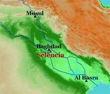
Edit: By the way, is there any chance you could fix the Tigris and Euphrates rivers an the provinces in that area. The city of Seleucia was a stones throw away from Babylon, not way out in the desert.

I'll correct the Tigris and Euphrates when I draw the rivers, I haven't done that yet. I don't know what to correct in provinces, show me and I'll correct it.


So, what do I have to do? Here is the list:

- Topology (hard)
- Terrain (very hard)
- Province resources (easy via random)
- Province population (easy via random)
- Province population split (easy via random)
- Country history/set up (easy or hard, depending on the country, but easy anyway via random)
- Indian names (easy via searching the net)
- Chinese names (easy via searching the net)
- Create kings and other existing characters (easy if I know they existed)
- Rivers (easy)
- Add after 280 BC history (new countries and all of that stuff) (easy or hard, depending on flags and history available for those countries)
- Add regions (easy)
- Add decisions, events, etc (easy if I know what to do and know how to do)
- Indian and chinese sprites for untis (very hard, have no idea how to do)
- Indian and chinese faces for characters (very hard)
- Add more provinces, we have lots of space to add what we want (Indochina, Korea, Japan, eurasian steppes, Nubia, Arabian coast are the most obvious ones) (easy to add, hard to name as I have no idea what to call them)

The very hard ones is where I think I will have lots of problems or simply can't do it. Topology is tricky, but I think I can sort of do it.

If you can help in any of these (even if they're "easy"), please go ahead :D

Many thanks for the support
 
Last edited:
You shouldn't worry too much about topology. After all, with your map scale, the Himalayas shouldn't protrude more than half a river's size above the map. ;)
The portraits shouldn't be that hard to do for someone who has some experience in PS/GIMP. I might give it a go, later on. :)
 
Is that... China I see! If you need any help with that (flags and such), let me know. I have started on a Chinese name file some time ago, so if you want I can complete and contribute that :)
 
Isn't there an event to create the Parthians? I don't understant what you mean. It it because the Parthians came from the East of the Caspian Sea?

I'll correct the Tigris and Euphrates when I draw the rivers, I haven't done that yet. I don't know what to correct in provinces, show me and I'll correct it.
The Parthians emerge by event in Vanilla EU:Rome because they had a major importance in the later start dates, yet the area they start in at the earliest date of the game isn't on the map. They were a nomadic group which lived between the Caspian and Aral Sea, just north of Seleucid Iranian possessions, who exploited Seleucid decline and seized virtually all of the Seleucid eastern domains.

Below is a more accurate representation of the region, with some modern cities for reference. The purple square marks the approximate location of Babylon, though I admit it might have been on the other side of the river. Point is, the EU: Rome representation is utterly farcical.
Seleucia.jpg

Yes Parthians were actually Parni, a tribe who lived north of Parthia, in the region called Dahae (between Parthia and Aral Sea). The lower river Oxus probably flowed trough there (it used to reach the Caspian sea). Maybe they can be made a very powerful tribe so that they can move into Parthia at some point? Even though they might be in danger of being conquered right away by the Seleucid player/AI...
 
It was suggested to change Hinduism into Brahmanism, add Jainism and change Vietnamese culture to Lac Viet. I did these changes.

I finally "finished" the large scale map, as I added Arabia, Africa and the east corners of the map.

africao.png

africa2.png


Of course this will be mostly eye candy as I have no plans to add provinces in most of Africa.

@lucaluca, I added your corrections:

corr1.png

corr2.png

corr3.png


I plan to do rivers next.

BTW, what do you think of this correction to the Babylonian rivers?

tigreeufrates.png


And what do you think of this Indus?

indus.png


I made a back-up of the mod up to now, it is here. If you want to, for example, add indian and chinese names, change the files and then send them to me.
 
Last edited:
Nice work, do you plan to add the arabian kingdoms on the peninsula, such as Saba, Hadramaut and Ma'in?

Arabia is there, so they're also targets to add. But unfortunately I don't know much about them.
 
Rivers done, criticism needed.

I added Aral Sea and moved the central asia lake a little east.

aralriver.png


Ganges and other indian rivers

ganges.png


Chinese madness of rivers

chineserivers.png


What do you think?
 
Very awesome.
I second that.

I was expecting comments like "Bastard, even my school kid that doesn't know what India is can draw a better Ganges" or "WTF, you call that an accurate chinese fluvial network? I call that a painting made by a drunk bunch of spaghetti" :D Thanks

I'll be constantly changing the files, so I'll create a link in the first page for everybody keep track of what's done and see the most current version of this "pre-mod". I'll include the date and hour of the most recent update and include a log with the changes from the previous version.

I plan to regions next, here is what I'm planning. Please comment.

regionsplan.png
 
Last edited:
I was expecting comments like "Bastard, even my school kid that doesn't know what India is can draw a better Ganges" or "WTF, you call that an accurate chinese fluvial network? I call that a painting made by a drunk bunch of spaghetti" :D Thanks
It does look a bit like spaghetti! :p
Seriously, I think you're doing a great job. Making authentic-looking rivers is hard, especially with your map scale.

I'll be constantly changing the files, so I'll create a link in the first page for everybody keep track of what's done and see the most current version of this "pre-mod". I'll include the date and hour of the most recent update and include a log with the changes from the previous version.
Sounds professional. ;)
 
ehi Camara you are so fast!:rofl:

I'll post my informations in the weekend. I was thinking to add more regions to Persia... aren't those regions a bit too big? Remember that regions are governed by governors, Maurya would have like 2-3 governors for the whole India. I'll give you my suggestion for the Seleucid regions with the other informations.
Also i have some corrections to suggest for the rivers Indus, Oxus and Ixartes, as well as suggestion for adding the rivers Margus and Ochus. These 2 rivers were flowing directly into the Karakum desert creating large oasis; the Margiana oasis especially was very important and rich.
 
When it comes to the regions, I'd say they're a bit large. The region names remind me of our anatomy classes (superior, inferior and media), but I guess it's hard to find suitable names in latin. What about using colonial divisions for India and China, with regions such as Rajputana and Gujurat? Personally, I don't think the Indians referred to the different parts of their country as "middle India", "upper India", "Ganges" and "Dravidia". They probably named them after the peoples living there, right?
 
I'll post my informations in the weekend. I was thinking to add more regions to Persia... aren't those regions a bit too big? Remember that regions are governed by governors, Maurya would have like 2-3 governors for the whole India. I'll give you my suggestion for the Seleucid regions with the other informations.
Also i have some corrections to suggest for the rivers Indus, Oxus and Ixartes, as well as suggestion for adding the rivers Margus and Ochus. These 2 rivers were flowing directly into the Karakum desert creating large oasis; the Margiana oasis especially was very important and rich.

Bring them! I also think regions are too big, the only problem I have with more regions is that I need to name them and need to make flags for them. Something a little research can do (for the flags, well, imagination only I think).
Don't forget to bring the rivers too :D

When it comes to the regions, I'd say they're a bit large. The region names remind me of our anatomy classes (superior, inferior and media), but I guess it's hard to find suitable names in latin. What about using colonial divisions for India and China, with regions such as Rajputana and Gujurat? Personally, I don't think the Indians referred to the different parts of their country as "middle India", "upper India", "Ganges" and "Dravidia". They probably named them after the peoples living there, right?

Yeah, they're too big. I think superior, inferior and media were used to refer to regions, but I didn't want to do that as... they're not supposed to be named after latin. The names are a problem, although they're not that important... (did I mention the flags yet? :D)

ehi Camara you are so fast!

I can't stop :eek: When I finish something I always start to think what to do next and end start doing it.
 
Which flags are you missing, specifically?

By the way, I'm honestly impressed by the amazing work you did on the map. Is the colormap_hires not needed?
 
I think superior, inferior and media were used to refer to regions
Sure, I didn't object to that! :D
Btw, if you're going to stick to Latin, you could start using cis- and trans-, as well as citerior and ulterior. It would be so awesome with a region called India Transhimalayana. :p

The names are a problem, although they're not that important... (did I mention the flags yet? :D)
True. But you're getting on quite nicely with the flags, aren't you? ;)
 
Which flags are you missing, specifically?

I mean the flags for the regions, not only countries need flags. I think it is a mechanism to allow them to declare independence (I haven't played much Rome since I bought it, so I'm not sure - but they indeed need it).

For now I have the flags for the countries presented (some with just their name [chinese ones], others with coins symbols, etc), I see I'll have a nightmare to create flags for the post-Maurya indian countries, they're so many! I mean, I can create "Lybia-like" flags, but I prefer do something that resembles at least vaguely the country.

By the way, I'm honestly impressed by the amazing work you did on the map.

Many thanks! The main problem I faced was to see if the vanilla map worked with 1/4 of its size. It did. After that, it was just add things. Thanks, but actually it was easy to deal with the map. Paint was enough and I was very confortable using it to do the map.

Is the colormap_hires not needed?

*FEAR* It is, and it will be a nightmare. Just try downloading the mod (available in the first post) and see for yourself what happens without the work in colormap_hires in the terrain view. Horrible, a true nightmare, as the new provinces will need that beatiful terrain otherwise they'll continue to be horrendous. I don't know if I can do it, I'm hoping someone with photoshop skills or something can tackle that problem. Fortunately there's the political map...

Sure, I didn't object to that!
Btw, if you're going to stick to Latin, you could start using cis- and trans-, as well as citerior and ulterior. It would be so awesome with a region called India Transhimalayana.

I said they were used, but I don't really want to use them in India and China, as latin there was just not used.

But you're getting on quite nicely with the flags, aren't you?

It's time to show the flags I have up to now! Just wait some minutes.
 
I mean the flags for the regions, not only countries need flags. I think it is a mechanism to allow them to declare independence (I haven't played much Rome since I bought it, so I'm not sure - but they indeed need it).
Yep. Don't forget region = <region name> in their country files, that's what makes them regional countries.