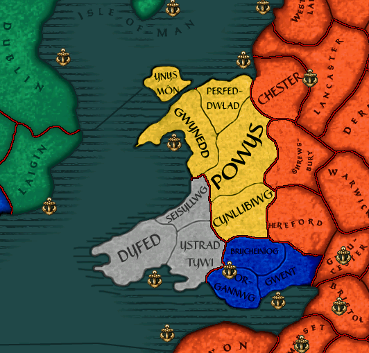
• We have updated our Community Code of Conduct. Please read through the new rules for the forum that are an integral part of Paradox Interactive’s User Agreement.
Veldmaarschalk said:
And now you want to 8 add more or an increase of almost 1/3

Yes, the raw number is not the point, it is balance between the added provinces verses England. The same revisions will have to go into place for Ireland and Scotland when we go there.

EVERY TIME there is a 1 income province England will claim it, war it, and win. All of them will be gone within a generation, unacceptably ahistorical. The increase in income is to balance England, which should not be able to steam-roll the other nations.

The arguments had always been that England was always overly strong, but the English camp did not want to reduce their incomes, so the Celtic Cressent was to be increased.

Had I not spoken up for Wales.... Wales would have remained an 11 without further consideration.

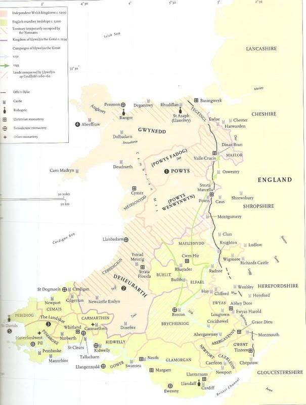
Reading through the thread you will see my initial request was for a higher number, between 20 and 26, for Wales, because I had then divided Wales basically into these provinces we have here and assigned numbers based off of Davies and other research.

This number is well within keeping of that research, does not effect England except cause them to wait a few generations longer before conquest, and we would have to revise Ireland and Scotland anyway!

EDIT: Wow, those conversations were 4 years ago and still valid today!
 
Last edited:
KK, in light of that committment, hehe, then I shall pull together my resources, find dynasties for those new provinces, and recommend geography. There is some fine tuning with the map of Wales still to do....

From the outset I can see that Kurek was influenced somewhat by a map appropriate for the Early Middle Ages rather then the High Middle Ages.

Outset Recommendations:

1. Seisyllwg (Seisyll's, or Cecil's, Country) should indeed be named Ceredigion ('Land of Ceredig') for the High Middle Ages.

2. Perfeddwald (Perfedd = 'middle', and (g)wald = 'country'), also known as Lower Gwynedd, should be hyphoned after the double d, so Perfedd-wald. The double d is one letter in Welsh and pronounced as th. And of corse a single f is pronounced as a v A double f (ff) makes the f sound as in English. So Ffranc for France, and Fenis for Venice.

3. Morgannwg (Morgan's Country) should be hyphoned after the first n, so Morgan-nwg.

4. Ynys Môn, for space restrictions, Môn would be appropriate as a stand alone name, dropping Ynys (Island). The name looks too squashed together otherwise.

5. Unsure at keeping Cynllibiwg (Cynllib's country), aka Rhwng Gwy a Hafren , meaning between Wye and Severn. This region was essentially to Powys what the Perfeddwald was to Gwynedd. Its origion is circumspect and ambigious. I will make some suggestions on this later.

6. Other map suggestions to follow.

7. I am uncertin if Dyfed or Pembroke should be the name of the region of Dyfed, given it must stand for 400 years and several scenarios. Likewise with Ystrad Tywi / Carmarthen.

Jord/Veld: Guidence here? Pembroke was established with the first invasions of Wales between 1067-1100, while Ystrad Tywi continued on as a province of an independent Principality of Wales (based on Gwynedd) until the 1282 Edwardian Conquest.


Gwynedd mountains
Môn should be plains
Perfeddwald should be hills

Powys should be hills
Cynllibiwg (if kept) should be hills

Ceredigion should be hills
Dyfed / Pembroke should be plains
Ystrad Tywi / Carmarthen should be hills or forest

Morgannwg should be hills
Breacons should be hills
Gwent should be forest
 
Cheers for the input! Changing names in the map is pretty easy seeing how I have in my master .pdf file the province names in separate layers from the other ones, so it's just a matter of changing some text in photoshop, copying and pasting a few different layers into the appropriate files, running the map compiler and bobs your uncle!

As to point 7, I could change to the town names, but in Welsh naturally so to fit in with the rest of the map ;) ie. Penfro and Caerfyrddin. I quite like Penfro actually, land's end and all that.

I did have Cynllibiwg originally as Rhwng Gwy a Hafren but that was a right bastard to write up on the map, so Cynllibiwg it shall be.

Thanks for the advice on terrain as well, I'll implement that along with the name changes for the next version. As for the whole income argument, I'll let you fellows wrangle out the details for that and just leave it how I have it for now, it's easy to modify the values yourself though.

And for an update report on Ireland, I've done hardly anything and for that I shall like to blame alcohol and laziness. ;) Think I'll get about working on that today though (being sober and bored helps). I need to free up four provinces, so I'll probably merge a bunch of sea provinces in the Atlantic as there are plenty of pointless small provinces on the borders of the map which can be done away with. And after that I can rape away all the rivers from the map as they don't really serve much point and come out looking ugly in the political map mode after I've compiled the map. If people really miss rivers I could always draw a bunch in on the colour tiles (terrain map view), they won't have any in game effects at all, just look nice. And along those lines I was looking at putting actual topographic maps over the terrain tiles, looked quite out of place but it is an interesting experiment.
 
Great!

I do have some suggestions on the way the map is drawn... but am trying to find a source for you.

As to S. Powys. i am thinking it may be more appropriate for our time frame to name it Powys Fadog for ther north, and Powys Wynwynwyn.... lemme think on it while I find you an on-line map.
 
Drachenfire said:
Great!

I do have some suggestions on the way the map is drawn... but am trying to find a source for you.

As to S. Powys. i am thinking it may be more appropriate for our time frame to name it Powys Fadog for ther north, and Powys Wynwynwyn.... lemme think on it while I find you an on-line map.

Here is map of medieval Wales

medwales.jpg
 
Apart from looking hilarious what does Wenwynwyn mean? According to wiki another name could be Powys Cyfeiliog. Could also rename Cynllibiwg to Maelienydd or something. The way I have the map drawn the two Powys' actually seem to fit inside my Powys one, so I could add in an extra province in the south of the main Powys if that's necessary.
 
Veldmaarschalk said:
Here is map of medieval Wales

medwales.jpg


Powys was divided following Llywelyn the Great's compleat subjection of Powys, and divided between the sons Madog and Gwenwynwyn. Thus Powys Fadog and Powys Wynwynwyn.

Powys Fadog was loyal to Llywelyn the Great... in point of fact his mother supposedly was the daughter of Madog Mathrafal of Powys Fadog.

I have no comment as yet. The text is very small for me on the map.
 
They don't have any effect. You're thinking of the EU series ;)
In theory they can be set to increase movement time, but that was not done. Even if this is done they will not have an effect on battles.
They serve no purpose in tech spreading either.
 
I hate to sound so very greedy, but the overall proportion of income could be maintained by maybe adjusting the provinces of England/Ireland/Scotland as well.

Therefore, it's something that could be figured out later after the historial (or not) map is settled first.
 
Curious, and have a point of note for the Ireland map, but, how easy is it to add the connections for techspread such? Specifically, on the vanilla map, with Desmumu, and for this one, with Corcaigh, there are a few places that Cork traded heavily with. Namely Galicia, in Spain, the Basque of Labourd, Leon in Brittany, Lisbon, and probably Wales and Cornwall. Cork was, even prior to the Cambro-Norman invasion, probably the most cosmopolitan Irish city, and was one of the places from which many ideas were transferred in and out of Ireland. Dublin's prominence shouldn't be understated, but it was neither as rich nor as well-positioned for trade with the continent, and instead traded more with Britain, and, via the north, in Scandinavia, and used some Scottish routes for Baltic trade as well. Not that, for Cork, I'd use all potential connections, just a few to give it a bit more clout as Ireland's southern cultural hub. As Desmumu, I'd just give it a few, so as to prevent all of Ireland's foreign developments coming from the east via Britain.
 
Yes, I didn't want to give too many, just kind of listing the main areas they were dealing in, and kind of pick the most appropriate over a long period from them.

And it's that easy? That's pretty nice, considering how much a pain a lot of other things are.
 
Somairle said:
Curious, and have a point of note for the Ireland map, but, how easy is it to add the connections for techspread such? Specifically, on the vanilla map, with Desmumu, and for this one, with Corcaigh, there are a few places that Cork traded heavily with. Namely Galicia, in Spain, the Basque of Labourd, Leon in Brittany, Lisbon, and probably Wales and Cornwall. Cork was, even prior to the Cambro-Norman invasion, probably the most cosmopolitan Irish city, and was one of the places from which many ideas were transferred in and out of Ireland. Dublin's prominence shouldn't be understated, but it was neither as rich nor as well-positioned for trade with the continent, and instead traded more with Britain, and, via the north, in Scandinavia, and used some Scottish routes for Baltic trade as well. Not that, for Cork, I'd use all potential connections, just a few to give it a bit more clout as Ireland's southern cultural hub. As Desmumu, I'd just give it a few, so as to prevent all of Ireland's foreign developments coming from the east via Britain.

For Wales the major trade routes came in from the south... Morgannwg and Dyfed... trade routes with Northern Spain and Brittany. In North Wales, Gwynedd and Mon should be connected with Ireland and Man.
 

Walesmapmod.png


KK, after refiew, this is my suggestion for the map.

1. The eastern border of Gwynedd should be moved eastward to match the Conwy river. For a reference on the map... the border would go between the P and he e in Perfedd, and also between the d and the w in 'dwald'. Then it would vere to the south east to the border of Powys. At first this would seem to make the Perfeddwald smaller, and it would... but I suggest also redrawing the eastern border to be more correct and have it closer to Chester. Currently, it appears the map gives a good fourth of the Perfeddwald to Chester.


2. I am certin now that the area now comprising Powys and Cynllibwg should be remapped. The northern third should be shaped more like Powys Fadog, while the southern half should be Powys Wenwynwyn. For Powys, the map should be shifted downward somewhat, so that Powys Wenwynwyn is also inhabiting Buillt and Maelienydd, both traditionally client commotes anyway.

3. I also think we should take special care to redraw the border with England to reflect more correctly Tegeingle and Maelor (where modern Wrecsam/Wrexham) is. But also redraw it to be more faithful to the historic borders of Wales.

4. I am having second thoughts on Dyfed and Ystrad Tywi. I think we should *keep* them Dyfed and Ystrad Tywi... your thoughts?

5. I think the provance for Dyfed should be cut in half, with Ceredigion enlarged, expanding more to the south along the cost, and also giving some to Ystrad Tywi.
 
Last edited:
Thanks a lot for these recommendations, I should be able to implement most of them without too much hassle. As to point 4. I'm happy with keeping the two names as they are, they just look cooler. ;)

If you could maybe drag that screen-shot into paint or whatever and draw on some borders yourself to give me a general rough plan for the more specific border modifications that would be great and make my job a little easier!

I probably won't be touching any map files for a couple of days, I spent most of yesterday wrestling with the Irish map and getting a bit stressed out when I couldn't get the bastard working in game. It's all completed apart from that, just that something going wrong somewhere it seems (probably something saved in the wrong format or a wrong colour being used somewhere or something tedious like that.)

Anyway, so I'll probably leave Ireland alone for the rest of the week and focus on re-doing Wales in a couple of days.

And a final note; at some point, as the mod title suggests, this will hopefully be a new map for the entirety of the British Isles, after I finally get a crude version of Ireland working in the game I would like to start working on Scotland but there's a problem, namely I do not know much about medieval Scotland, and almost nothing about the political situation, so if anyone has any suggestions or resources or ideas then feel free to chime in and argue now about what should go where and all that. I did find a map of Lordship's in medieval Scotland on Wiki but no doubt someone out there will have other ideas.

Anyway, here's a prov ID map for what I got assigned for Ireland, just need the blasted map working that's all ;)

ireprovid-1.png
 
For Kurek and Drachenfire, maybe a connection tween Dyfed and Urmumu? That is where the Deisi Mumu set out from centuries earlier to fight in Demetia (funny, long, odd story behind that whole event). And it was from where the Munstermen got their first longbow regiment (2000 longbows for the fortress of Cashel, in Desmumu on the CK map, was guarded by a permanent, retained regiment of 2000 longbows, imported from Wales at first, and then reinforced later with local bows; they came in through 'East Munster', Urmumu). edit: Heh, a note on that. Those are from the 1080s. They were, in one theory, imitating Welsh mercenaries. The Munstermen and Leinstermen used them a lot to bolster their numbers. In the 1080s, Munster decided to import Welsh longbows, and train their own longbowmen. Just to give some context for the thought given here beyond the 'dark age' (hate that term) connections.